
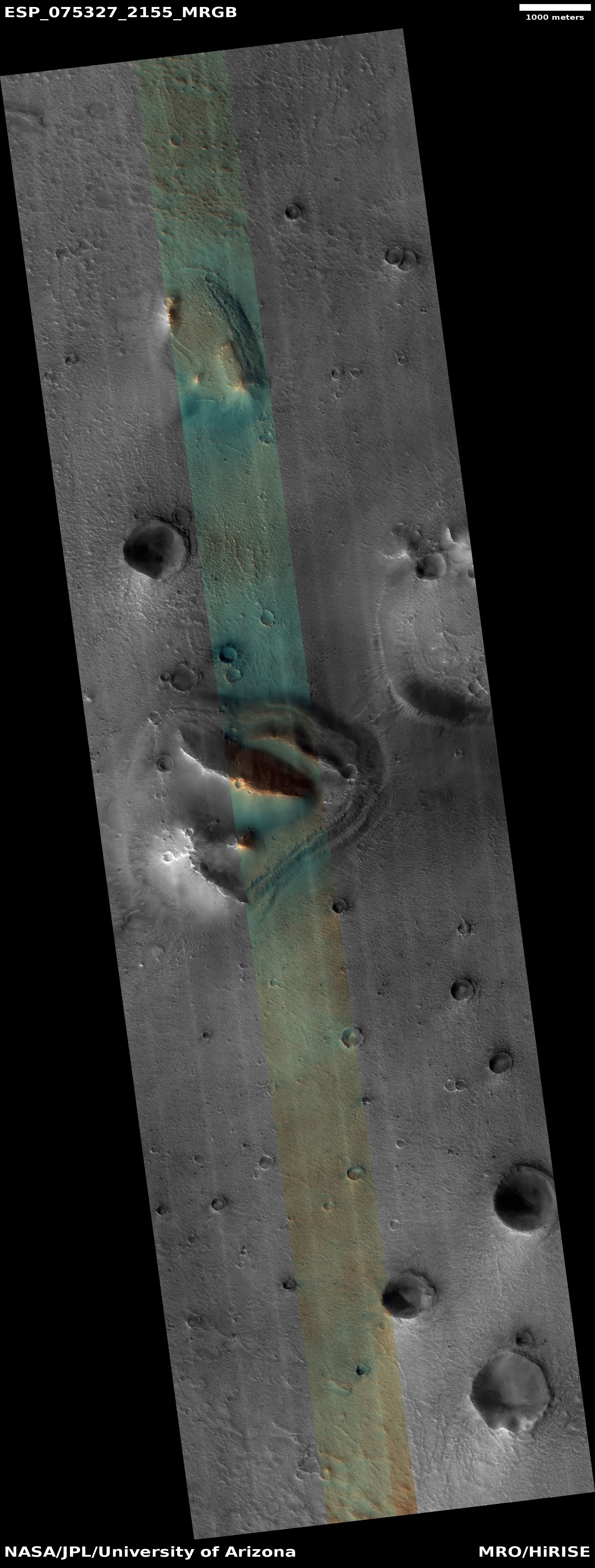
A Martian knife mesa with terraces
Click for full image.
Cool image time! The photo to the right, rotated, cropped, reduced, and sharpened to post here, was taken on August 21, 2022 by the high resolution camera on Mars Reconnaissance Orbiter (MRO). It shows what the scientists label as a “layered mound.” It also shows a plethora of geological mysteries, all of which relate to the as yet not quite understood geological history of Mars.
First, note the different colors north and south of the ridgeline. According to the science team’s understanding of what these colors mean [pdf], the orange-red to the north suggests dust, while the bluish-green to the south suggests coarser materials, such as rocks and sand. Though frost and ice are generally bluer, such things are generally found on the pole-facing slopes where there is less sunlight. Thus the bluish-green material to the south is unlikely to be ice or frost, though this is not impossible, as the picture was taken in the winter and the latitude is 35 degrees north.
Why however is there such a dichotomy of rocks, sand, and dust between the north and south slopes? And if frost and ice, why is it more prominent to the south, when it should instead be more prominent to the north?
Other mysteries: Is the circular depression on the ridgetop an impact crater or a caldera? If the latter, this suggests the mound is some kind of volcano, likely mud, though lava is not excluded. If so, however, why is there no caldera on top of the ridge to the south?
The location, as shown in the overview map below, reveals other puzzles.
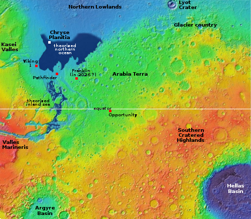
The white dot marks the location of this terraced mound, inside an area that some scientists think might have once held an intermittent ocean. If so, did this mound form before, during, or after the existence of that ocean? A first guess would say, assuming this is a mud volcano, that it formed either during or after, as part of the drying-out process, but that is not certain. If a lava volcano it could have formed before, and survived the ocean with little change.
This conclusion of course assumes the ocean itself once existed, which is also uncertain and only theorized based on simulations and the known topography.
Though this location is far enough north, at 35 degrees latitude, for it to have near surface ice present, all the features in the full image appear very dry. Apparently, at this location any ice is underground, and is deep enough that it is not making its presence evident in surface features.
All guesses. This mound is gives us just enough information to allow us to guess, but not know.

On Christmas Eve 1968 three Americans became the first humans to visit another world. What they did to celebrate was unexpected and profound, and will be remembered throughout all human history. Genesis: the Story of Apollo 8, Robert Zimmerman's classic history of humanity's first journey to another world, tells that story, and it is now available as both an ebook and an audiobook, both with a foreword by Valerie Anders and a new introduction by Robert Zimmerman.
The print edition can be purchased at Amazon or from any other book seller. If you want an autographed copy the price is $60 for the hardback and $45 for the paperback, plus $8 shipping for each. Go here for purchasing details. The ebook is available everywhere for $5.99 (before discount) at amazon, or direct from my ebook publisher, ebookit. If you buy it from ebookit you don't support the big tech companies and the author gets a bigger cut much sooner.
The audiobook is also available at all these vendors, and is also free with a 30-day trial membership to Audible.
"Not simply about one mission, [Genesis] is also the history of America's quest for the moon... Zimmerman has done a masterful job of tying disparate events together into a solid account of one of America's greatest human triumphs."--San Antonio Express-News
I’ve listened to you for years on John Batchelor. This is great stuff. Thanks.