
The alien landscape of Mars’ north polar ice cap
Click for original image.
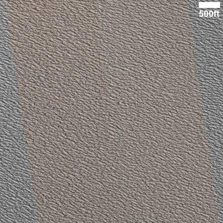
Cool image time! The picture to the right, cropped to post here, was taken on August 24, 2025 by the high resolution camera on Mars Reconnaissance Orbiter (MRO).
The camera team labels this simply as a “terrain sample,” which usually means it was not taken as part of any specific research request, but to fill a gap in the camera’s schedule in order to maintain its proper temperature. When they need to do this, they try to find interesting things to photograph, and mostly succeed.
At first glance the picture to the right does not appear that interesting. If anything it shows an endless expanse of mottled terrain, with no features of any interest at all. This sameness however is what makes this picture and landscape intriguing. What caused it to look this way?
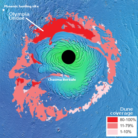
The white dot on the overview map to the right marks the location, approximately a hundred miles from Mars’ north pole and on top of the red planet’s ice cap. As I noted in a June 2019 article,
The polar cap … is 600 miles across and a little less than 7,000 feet deep. It is made up of many seasonal layers, like the icecaps on Earth, with the bulk a mixture of water ice and cemented dust and sand. The very top layers, dubbed the residual icecap, is about three to six feet thick made up of frozen water having a volume about half of Greenland’s icecap. While this water could sublimate away, data suggests it is, like the icecaps on Earth, in a steady state, neither gaining or losing volume with each Martian year.
Above the residual icecap of water is the seasonal icecap made up of carbon dioxide. Unlike the other layers, this seasonal cap of dry ice, also less than six feet thick, comes and goes with the seasons. During the Martian summer it is gone, the carbon dioxide having sublimated away into the atmosphere. As the weather chills however that carbon dioxide begins to freeze again, falling as CO2 snow on the surface at the poles to create a thin cap of dry ice extending down to about 60 degrees latitude and covering practically everything seen [on the map above].
The terrain here is the result of that dry ice snow falling and sublimating away each year. As it does so, it apparently causes the top layer of water ice to corrode, producing this endless landscape of scallops. Nor is this terrain unusual. See for example an earlier post from 2021, showing similar terrain further south but still on the ice cap. In that case the endless scalloped landscape had been brokent by two recent small impacts.

On Christmas Eve 1968 three Americans became the first humans to visit another world. What they did to celebrate was unexpected and profound, and will be remembered throughout all human history. Genesis: the Story of Apollo 8, Robert Zimmerman's classic history of humanity's first journey to another world, tells that story, and it is now available as both an ebook and an audiobook, both with a foreword by Valerie Anders and a new introduction by Robert Zimmerman.
The print edition can be purchased at Amazon or from any other book seller. If you want an autographed copy the price is $60 for the hardback and $45 for the paperback, plus $8 shipping for each. Go here for purchasing details. The ebook is available everywhere for $5.99 (before discount) at amazon, or direct from my ebook publisher, ebookit. If you buy it from ebookit you don't support the big tech companies and the author gets a bigger cut much sooner.
The audiobook is also available at all these vendors, and is also free with a 30-day trial membership to Audible.
"Not simply about one mission, [Genesis] is also the history of America's quest for the moon... Zimmerman has done a masterful job of tying disparate events together into a solid account of one of America's greatest human triumphs."--San Antonio Express-News
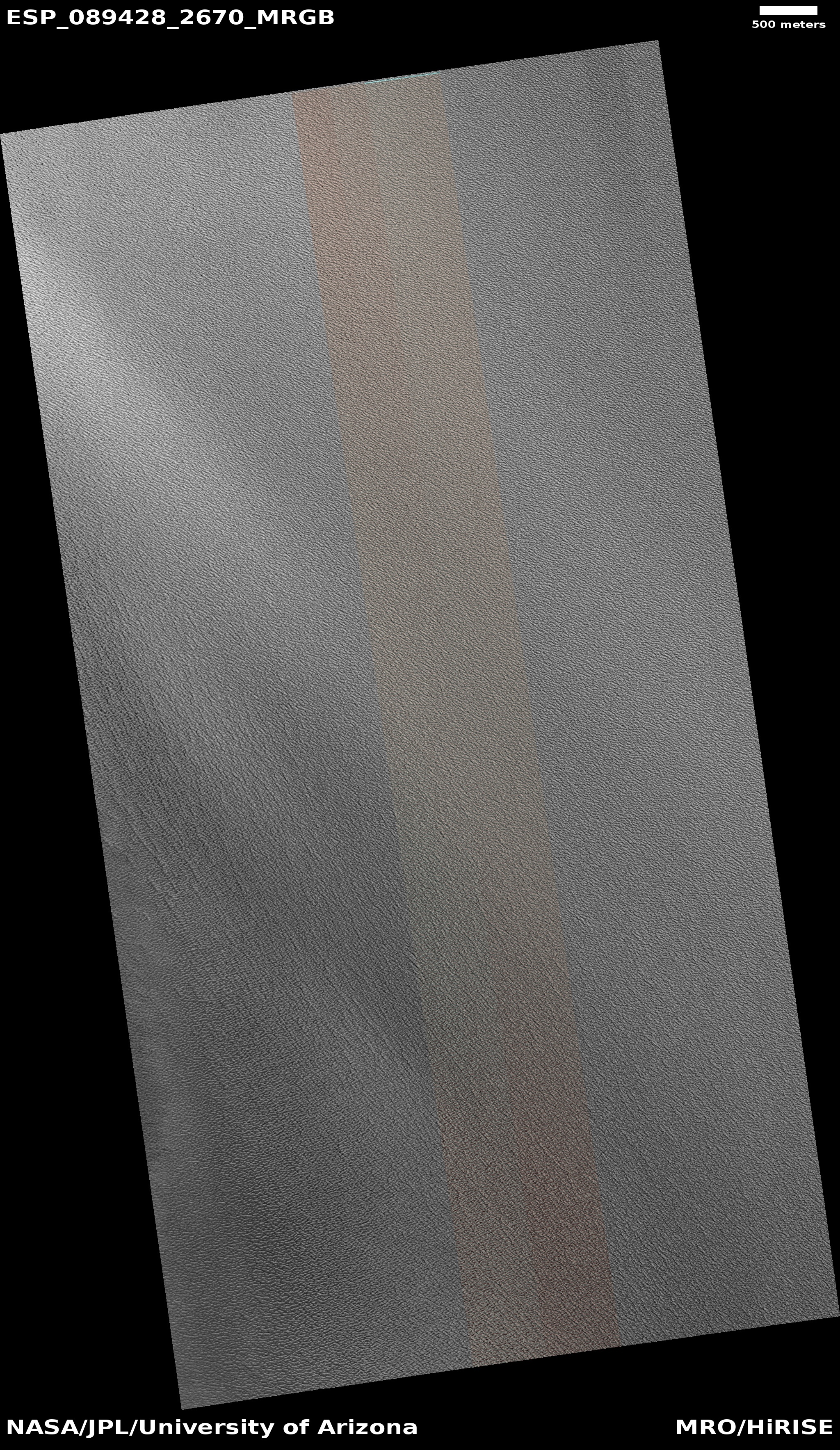
Click for original image.
Cool image time! The picture to the right, cropped to post here, was taken on August 24, 2025 by the high resolution camera on Mars Reconnaissance Orbiter (MRO).
The camera team labels this simply as a “terrain sample,” which usually means it was not taken as part of any specific research request, but to fill a gap in the camera’s schedule in order to maintain its proper temperature. When they need to do this, they try to find interesting things to photograph, and mostly succeed.
At first glance the picture to the right does not appear that interesting. If anything it shows an endless expanse of mottled terrain, with no features of any interest at all. This sameness however is what makes this picture and landscape intriguing. What caused it to look this way?
The white dot on the overview map to the right marks the location, approximately a hundred miles from Mars’ north pole and on top of the red planet’s ice cap. As I noted in a June 2019 article,
The polar cap … is 600 miles across and a little less than 7,000 feet deep. It is made up of many seasonal layers, like the icecaps on Earth, with the bulk a mixture of water ice and cemented dust and sand. The very top layers, dubbed the residual icecap, is about three to six feet thick made up of frozen water having a volume about half of Greenland’s icecap. While this water could sublimate away, data suggests it is, like the icecaps on Earth, in a steady state, neither gaining or losing volume with each Martian year.
Above the residual icecap of water is the seasonal icecap made up of carbon dioxide. Unlike the other layers, this seasonal cap of dry ice, also less than six feet thick, comes and goes with the seasons. During the Martian summer it is gone, the carbon dioxide having sublimated away into the atmosphere. As the weather chills however that carbon dioxide begins to freeze again, falling as CO2 snow on the surface at the poles to create a thin cap of dry ice extending down to about 60 degrees latitude and covering practically everything seen [on the map above].
The terrain here is the result of that dry ice snow falling and sublimating away each year. As it does so, it apparently causes the top layer of water ice to corrode, producing this endless landscape of scallops. Nor is this terrain unusual. See for example an earlier post from 2021, showing similar terrain further south but still on the ice cap. In that case the endless scalloped landscape had been brokent by two recent small impacts.
On Christmas Eve 1968 three Americans became the first humans to visit another world. What they did to celebrate was unexpected and profound, and will be remembered throughout all human history. Genesis: the Story of Apollo 8, Robert Zimmerman's classic history of humanity's first journey to another world, tells that story, and it is now available as both an ebook and an audiobook, both with a foreword by Valerie Anders and a new introduction by Robert Zimmerman.
The print edition can be purchased at Amazon or from any other book seller. If you want an autographed copy the price is $60 for the hardback and $45 for the paperback, plus $8 shipping for each. Go here for purchasing details. The ebook is available everywhere for $5.99 (before discount) at amazon, or direct from my ebook publisher, ebookit. If you buy it from ebookit you don't support the big tech companies and the author gets a bigger cut much sooner.
The audiobook is also available at all these vendors, and is also free with a 30-day trial membership to Audible.
"Not simply about one mission, [Genesis] is also the history of America's quest for the moon... Zimmerman has done a masterful job of tying disparate events together into a solid account of one of America's greatest human triumphs."--San Antonio Express-News
Looks like nothing quite so much as a stuccoed wall. As our host is doubtless well aware, there is an area of elevated flatlands in the American Southwest known by the Spanish name Llano Estacado – the “staked plains.” Perhaps we could dub this Martian polar landscape in Spanglish as Llano Estuccodo – the “stuccoed plains.”
No crisscrossing. All streaks in one direction. Prevailing wind?
The polar cap … is 600 miles across and a little less than 7,000 feet deep. It is made up of many seasonal layers, like the icecaps on Earth, with the bulk a mixture of water ice and cemented dust and sand. The very top layers, dubbed the residual icecap, is about three to six feet thick made up of frozen water having a volume about half of Greenland’s icecap.
The foregoing, quoted above from the previous article (which I haven’t checked), is worded perhaps imprecisely—because the top 3-6′ (“residual ice cap”) of the martian north polar ice cap, can’t possibly contain ~1/2 of Greenland’s mile-deep ice sheet. Instead, it’s the entirety of the water-ice in the (up to 3.7 km deep) “layered deposits” lying below the residual ice cap that add up to (perhaps a bit more than) half of Greenland’s ice.