
First visual detection of another star’s heliosphere
Click for full image.
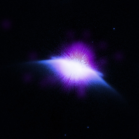
Using both the Hubble Space Telescope and the Chandra X-ray Observatory, astronomers have made the first visual detection of another star’s heliosphere, in both X-rays and in the infrared.
The image to the right, cropped to post here.
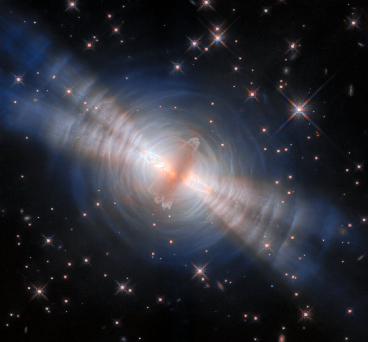
Astronomers have nicknamed the HD 61005 star system the “Moth” because it is surrounded by large amounts of dust patterned similarly to the shape of a moth’s wings when viewed through infrared telescopes. The wings are formed from material left behind after the formation of the star, similar to the Kuiper Belt in our own solar system. Observations of these wings with NASA’s Hubble Space Telescope showed that the interstellar matter surrounding HD 61005 is about a thousand times denser than that around the Sun.
The wings are the points to the left and right. The star’s young heliosphere, which they dub an “astrosphere,” is the purple glow above and below. From the caption:
In this composite image of HD 61005 in the inset, X-rays from Chandra (purple and white) have been combined with infrared data from Hubble (blue and white). Chandra reveals a bright source of X-rays in the center of the image, which is the star itself surrounded by the star’s astrosphere. The wing-like structure sweeping away from the star in the infrared image is dusty material that remained behind after the formation of the star. These wings have been swept backwards as they fly through space.
As this star and its solar system are very young, what we have is a very dusty accretion disk interacting with a very temperamental baby star.

Click for full image.
Using both the Hubble Space Telescope and the Chandra X-ray Observatory, astronomers have made the first visual detection of another star’s heliosphere, in both X-rays and in the infrared.
The image to the right, cropped to post here.
Astronomers have nicknamed the HD 61005 star system the “Moth” because it is surrounded by large amounts of dust patterned similarly to the shape of a moth’s wings when viewed through infrared telescopes. The wings are formed from material left behind after the formation of the star, similar to the Kuiper Belt in our own solar system. Observations of these wings with NASA’s Hubble Space Telescope showed that the interstellar matter surrounding HD 61005 is about a thousand times denser than that around the Sun.
The wings are the points to the left and right. The star’s young heliosphere, which they dub an “astrosphere,” is the purple glow above and below. From the caption:
In this composite image of HD 61005 in the inset, X-rays from Chandra (purple and white) have been combined with infrared data from Hubble (blue and white). Chandra reveals a bright source of X-rays in the center of the image, which is the star itself surrounded by the star’s astrosphere. The wing-like structure sweeping away from the star in the infrared image is dusty material that remained behind after the formation of the star. These wings have been swept backwards as they fly through space.
As this star and its solar system are very young, what we have is a very dusty accretion disk interacting with a very temperamental baby star.


