Sinkholes galore!

Sinkholes galore south of Olympus Mons
Click for full image.

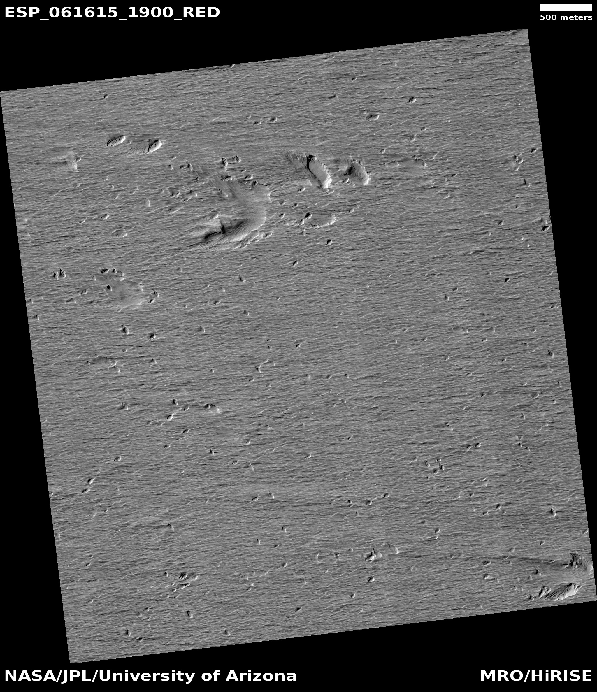
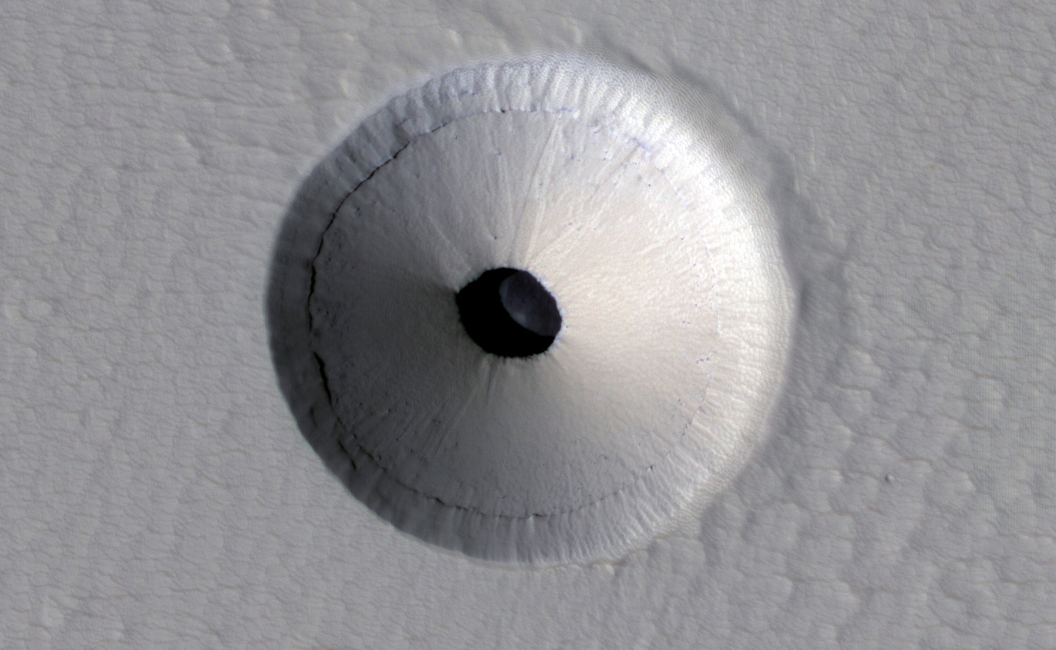
Cool image time! The photograph to the left, cropped to post here, was part of the November image dump from the high resolution camera on Mars Reconnaissance Orbiter (MRO). It shows a wind-swept dusty plain trending downhill to the west that is filled with more than a hundred depressions or sinkholes.

Unlike other pit images I have posted previously, this one is not focused on one particular pit or a string of pits. Instead, what makes it interesting is the large number of pits, scattered across the terrain in a random pattern. Their random distribution suggests that they are unrelated to any specific underground feature, such as a lava tube. Instead, some aspect of the underground geology here is causing the ground to sink at random points.

Below is an overview map showing where this dusty pit-strewn plain is located, indicated by the blue cross.
» Read more

Active sinkholes found on Comet 67P/C-G

pits on Comet 67P/C-G

Cool image time! Using Rosetta’s high resolution camera scientists have located a number of active pits similar to sinkholes on Earth on Comet 67P/C-G.

Based on the Rosetta observations, the team has proposed a model for the formation of these sinkholes. A source of heat beneath the comet’s surface causes ices (primarily water, carbon monoxide and carbon dioxide) to sublimate. The voids created by the loss of these ice chunks eventually grow large enough that their ceilings collapse under their own weight, giving rise to the deep, steep-sided circular pits seen on the surface of comet 67P/Churyumov-Gerasimenko.

The collapse exposes comet ices to sunlight for the first time, which causes the ice chunks to begin sublimating immediately. These deeper pits are therefore thought to be relatively young. Their shallower counterparts, on the other hand, are most likely older sinkholes with more thoroughly eroded sidewalls and bottoms that have been filled in by dust and ice chunks.

Essentially, they have found that decay of the comet’s nucleus has been mostly gentle and steady, rather than explosive, punctuated with sudden abrupt events.

The caves of Copernicus
and the Ocean of Storms

The discovery of new caves on the Moon keep coming. Today I have two new stories. The first is a discovery by professional scientists of a giant lava tube cave in the Oceanus Procellarum or Ocean of Storms. The second is the detection of a plethora of caves and sinks on the floor of the crater Copernicus, found by a NASA engineer who likes to explore the gobs of data being accumulated by Lunar Reconnaissance Orbiter and made available to all on the web.

The image below of the Moon’s near side, taken by India’s Cartosat-2A satellite and taken from the science paper, shows the location of lava tube in Oceanus Procellarum (indicated by the red dot) and the crater Copernicus.

The Moon's near side, annotated

First the professional discovery. Yesterday, the Times of India reported the discovery of lava tube more than a mile long on the Moon. I did not post a link to the article because I didn’t think the news story provided enough information to make it worth passing along. Today however, fellow caver Mark Minton emailed me the link where the actual research paper could be downloaded [pdf]. This I find definitely worth describing.
» Read more

Sinkholes on Mars

Caver alert! Releases this week from both the Mars Express orbiter and the Mars Reconnaissance Orbiter show a variety of sinkholes and collapse features on Mars, which in turn suggest the possibility of underground passages.

First, there is this picture from Mars Express, showing the area called Phoenicis Lacus (Latin for Phoenix Lake).

Phoenicis Lacus

The large and long canyon in box 1 is actually a collapse feature, almost two miles deep and formed as this region was stretched, warped, and cracked by the powerful volcanic activity of the nearby giant volcanoes of the Tharsis plateau, including Olympus Mons, the solar system’s largest volcano. You can also see how this activity causes several sinkholes and craters in all three boxes to become elongated and distorted.

In places where the surface is deformed in this way on Earth, you often find tectonic caves, underground cracks produced as the ground is pulled apart. The large collapse feature suggests the possibility that there are voids below it.

Then there is this subimage from this release of Mars Reconnaissance Orbiter, showing the central peak and southern slope of an old crater in the Terra Sirenum region of the Martian southern hemisphere.

central crater peak

Down that south slope can be seen what look like fluvial-like flows. In the center of these flows as well as near the top of the peak are what appear to be a string of collapse features. Below is the close-up as indicated by the box above:

inset closeup of sinkholes

From the caption: “It is possible that these pits are evidence of subsurface piping or hydrothermal activity. Piping occurs when subsurface water flows through soil, takes some soil with it, and causes the overlying ground to collapse. These fluvial-like features and the connected pits may have formed during a late stage of crater formation when temperatures were suitable for liquid water.”

On Earth, this is one of the geological processes that forms sinkholes on the surface as well as caves underground. When cavers go out to look or dig for new caves, we often head for just this kind of string of sinkholes, as they are excellent evidence that an unentered cave lies hidden below, ripe for exploration.