A Mars mesa carved by floods and lava?

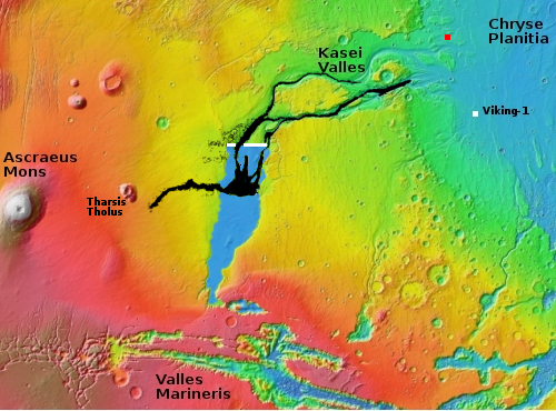
With today’s cool image we once again start our journey from afar, and zoom in. The overview map to the right focuses in on the thousand-mile-long Kasei Valley on Mars.
The blue area is where scientists postulate a lake once existed, held there by an ice dam (indicated by the white line). At some point that ice dam burst, releasing the water in a catastrophic flood that created the braided flow features that continue down Kasei Valles to the northern lowland plain of Chryse Planitia.
The black area marks a giant lava flow that scientists believe came later, following the already carved stream channels for a distance of 1,000 miles, traveling at speeds of 10 to 45 miles per hour.
The red dot near the Kasei Valles resurgence is today’s cool image.
The first picture to the right, cropped, reduced, and enhanced to post here, was taken in December 2012 by the wide angle context camera on Mars Reconnaissance Orbiter (MRO). It shows the floor of Kasei Valles at this outlet point.
Note the flow features on the valley floor, pushing through the large gap between the large mesa to the north and the small mesas to the south. Though we know that material is dust, sand, and debris, partly shaped by wind over the eons, if you let your imagination run a bit you can almost see these features as rapidly flowing water, pushing like river rapids through a narrow gap.
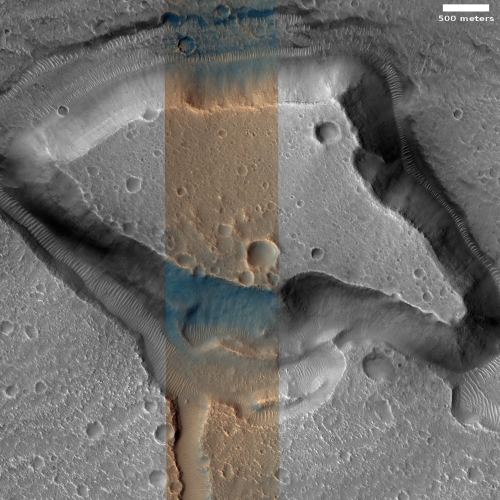
The black cross marks the mesa shown in the second picture to the right, rotated, cropped, and reduced to post here. Taken on May 22, 2021 by MRO’s high resolution camera, it not only gives us a close-up of that mesa and its features, the color strip down the center tells us that there are some fundamental differences between the mesa’s south cliff face and the surrounding terrain. That cliff is even different than the north cliff, which though it has blue areas near its base, its bulk is tan-colored.
What do the colors mean? Let me quote the explanation [pdf] provided by the MRO science team:
Dust (or indurated dust) is generally the reddest material present and looks reddish. … Coarser-grained materials (sand and rocks) are generally bluer … but also relatively dark, except where coated by dust. Frost and ice are also relatively blue, but bright, and often concentrated at the poles or on pole-facing slopes. Some bedrock is also relatively bright and blue, but not as much as frost or ice, and it has distinctive morphologies.
Since the blue cliff is south-facing, it is not likely that the blue color is from ice or frost, even though the location is at 31 degrees north latitude and it is spring, when frost might still exist at this location. More likely the blue indicates we are looking at either bedrock or coarser-grained materials like sand and rocks. That the north cliff is more tan probably means it is more covered with dust, which makes sense if you look at the south-pointing wind streaks around craters in the context camera photo. The prevailing wind is to the south, which means more dust will be blown against the north-facing cliff.
There is also the depression surrounding the mesa. The higher surrounding ground appears solid like bedrock, with many craters, suggesting to me that it is a lava flow. The crater count on the top of the mesa appears about the same, which suggests they formed at about the same time. If so, why is the mesa uplifted, or why did the surrounding terrain drop?
It is also possible that the surrounding terrain once pressed against the cliff. With time erosion — possibly caused by those catastrophic floods — caused that cliff face to retreat, leaving that moat at its base.
All guesses of course. The evidence suggests that this terrain’s formation was influenced by both volcanic and hydrological processes, then later shaped by climate and wind. How those factors fit together precisely remains unclear.
On Christmas Eve 1968 three Americans became the first humans to visit another world. What they did to celebrate was unexpected and profound, and will be remembered throughout all human history. Genesis: the Story of Apollo 8, Robert Zimmerman's classic history of humanity's first journey to another world, tells that story, and it is now available as both an ebook and an audiobook, both with a foreword by Valerie Anders and a new introduction by Robert Zimmerman.
The print edition can be purchased at Amazon or from any other book seller. If you want an autographed copy the price is $60 for the hardback and $45 for the paperback, plus $8 shipping for each. Go here for purchasing details. The ebook is available everywhere for $5.99 (before discount) at amazon, or direct from my ebook publisher, ebookit. If you buy it from ebookit you don't support the big tech companies and the author gets a bigger cut much sooner.
The audiobook is also available at all these vendors, and is also free with a 30-day trial membership to Audible.
"Not simply about one mission, [Genesis] is also the history of America's quest for the moon... Zimmerman has done a masterful job of tying disparate events together into a solid account of one of America's greatest human triumphs."--San Antonio Express-News


“A Princess of Mars”
Edgar Rice Burroughs (1912)
https://youtu.be/OgCR6OVh-ec
7:19:26