
Another “What the heck?” photo from Mars
Click for full image.
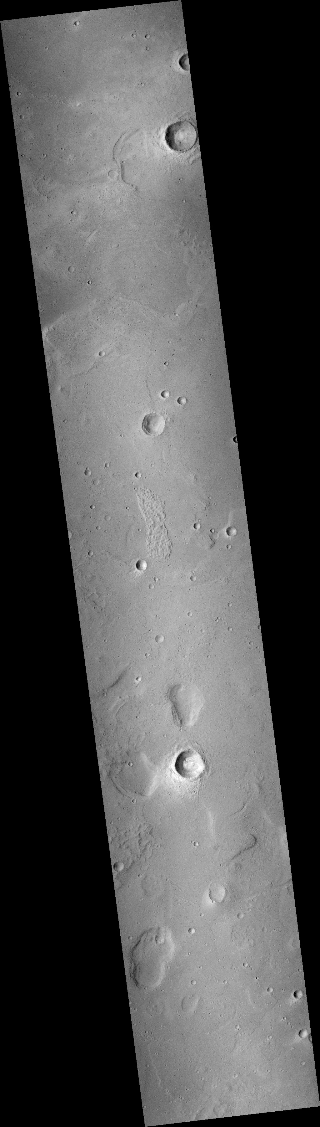
The cool image to the right, cropped and reduced to post here, was taken a decade ago, on August 25, 2011, by the context camera on Mars Reconnaissance Orbiter (MRO), It shows a flat plain with a sudden clump of mounds or hills at the center.
This is one of those pictures from Mars which I like to call a “What the heck?” image. What caused the mounds, and why are they found only in this concentrated clump, with the rest of the terrain around them generally flat?
Though the context image was taken a decade ago, no follow-up high resolution images were taken of this area until very recently.
Below is the one recent high resolution image taken by MRO on May 12, 2021, cropped and reduced to show the bottom half of the mound clump as shown by the white box. It makes the mystery even more puzzling.
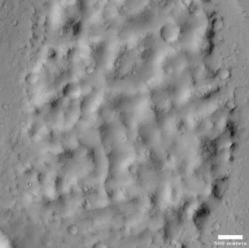
For example, note that there are a lot of craters on the mound clump. Though I haven’t done a proper crater count, it appears at first glance that the rate of impacts on the clump is somewhat comparable to the rate of impacts on the surrounding plains. This suggests that if the clump is showing us the peaks of mountains that a flood lava mostly buried, both are very very old.
The age of this feature is reinforced by its look. The edge of the clump does not look like the edge of a lava flow, as seen seen elsewhere on Mars. The ground, while smooth, does not show a distinct “sea level” that abruptly ends at the mounds. Instead, it continues right up to and even into the clump, transitioning seamlessly onto the mounds. Either the surrounding plains are not flood lava, or the flood happened so long ago that erosion has smoothed everything out. The rounded look of the mounds adds weight to this theory.
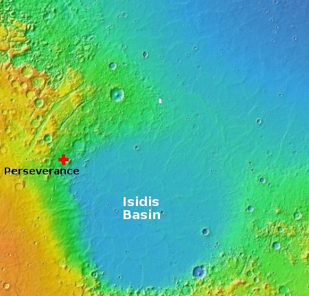
The location, as shown by the white dot in the overview map to the right, doesn’t help either. This clump is just on the border between the northern lowland plains and the transition zone up to the cratered highlands. It is also very near Isidis Basin, one of the largest basins on Mars and believed created by an impact 4 billion years ago. That impact left behind many lava flood and impact melt features, but is this clump one of them?
That the clump is on the margin of both the lowland plains and the transition zone means that the processes that formed either could have also formed it. That it is located at 25 degrees north latitude means that if ice had ever been involved it was a long time ago, when the rotational tilt of Mars was different than it is now.
The location is about 800 miles northeast of Perseverance, and about 2,000 miles west of China’s Zhurong rover (which is just east off the edge of this overview map). In fact, the clump sits at almost the same latitude as Zhurong. If that rover finds evidence of an underground ice layer there, than it will suggest such a thing might exist here, and help explain this strange clump of hills.

On Christmas Eve 1968 three Americans became the first humans to visit another world. What they did to celebrate was unexpected and profound, and will be remembered throughout all human history. Genesis: the Story of Apollo 8, Robert Zimmerman's classic history of humanity's first journey to another world, tells that story, and it is now available as both an ebook and an audiobook, both with a foreword by Valerie Anders and a new introduction by Robert Zimmerman.
The print edition can be purchased at Amazon or from any other book seller. If you want an autographed copy the price is $60 for the hardback and $45 for the paperback, plus $8 shipping for each. Go here for purchasing details. The ebook is available everywhere for $5.99 (before discount) at amazon, or direct from my ebook publisher, ebookit. If you buy it from ebookit you don't support the big tech companies and the author gets a bigger cut much sooner.
The audiobook is also available at all these vendors, and is also free with a 30-day trial membership to Audible.
"Not simply about one mission, [Genesis] is also the history of America's quest for the moon... Zimmerman has done a masterful job of tying disparate events together into a solid account of one of America's greatest human triumphs."--San Antonio Express-News
I have heard of “Chariots of the Gods”, but “Drywall of the Gods”? Also kind of looks like a peanut.
Seriously, looks about 5 to 7km wide and 30km long. Any heights on the hills? Ceratinly not moraine. I thought at first it was a lava flow. Probably just an eroded mountain.
I found the feature south of the formation more interesting: a crater and two depressions. Perhaps you have covered this, Robert? Would appreciate the link, if so.
Blair K Ivey: Nope, I haven’t covered these features, as this is a very recent image, and there have been no other high resolution images by MRO taken of this area before this.
And yes, that crater and those two depressions are equally puzzling.
This is where you really need a stereopair . . .