
Ingenuity completes 34th flight using new hazard avoidance software
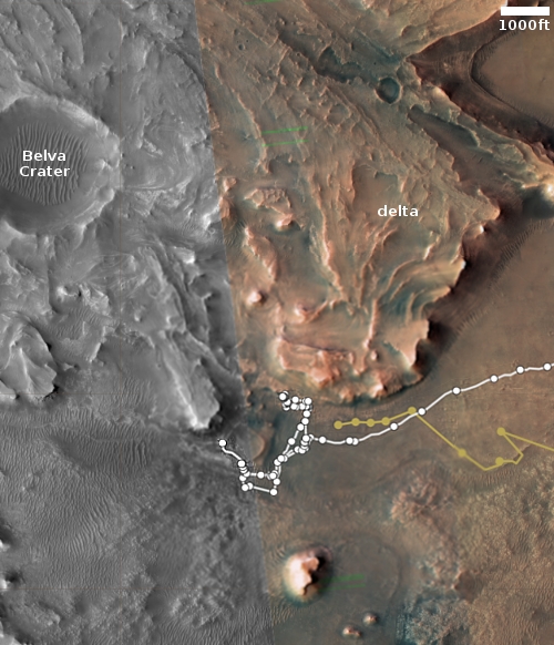
Click for interactive map.
Ingenuity yesterday completed its 34th flight on Mars, a short vertical up-and-down flight lasting only eighteen seconds in order to test just installed new hazard avoidance software.
The tan dotted line on the map to the right shows Ingenuity’s recent flights and ends where it sits today. The white dotted line marks Perseverance’s travels.
Ingenuity’s navigation software was designed to assume the vehicle was flying over flat terrain. When the helicopter is flying over terrain like hills, this flat-ground assumption causes Ingenuity’s navigation software to think the vehicle is veering, causing Ingenuity to start actually veering in an attempt to counter the error. Over long flights, navigation errors caused by rough terrain must be accounted for, requiring the team to select large airfields. This new software update corrects this flat-ground assumption by using digital elevation maps of Jezero Crater to help the navigation software distinguish between changes in terrain and vehicle movement. This increases Ingenuity’s accuracy, allowing the pilots to target smaller airfields going forward.
The new software is part of an effort to use Ingenuity to test helicopter flying in Jezero Crater in preparation for the two sample return helicopters which will eventually land here to grab Perservance’s core samples and bring them to the ascent vehicle for return to Earth.

On Christmas Eve 1968 three Americans became the first humans to visit another world. What they did to celebrate was unexpected and profound, and will be remembered throughout all human history. Genesis: the Story of Apollo 8, Robert Zimmerman's classic history of humanity's first journey to another world, tells that story, and it is now available as both an ebook and an audiobook, both with a foreword by Valerie Anders and a new introduction by Robert Zimmerman.
The print edition can be purchased at Amazon or from any other book seller. If you want an autographed copy the price is $60 for the hardback and $45 for the paperback, plus $8 shipping for each. Go here for purchasing details. The ebook is available everywhere for $5.99 (before discount) at amazon, or direct from my ebook publisher, ebookit. If you buy it from ebookit you don't support the big tech companies and the author gets a bigger cut much sooner.
The audiobook is also available at all these vendors, and is also free with a 30-day trial membership to Audible.
"Not simply about one mission, [Genesis] is also the history of America's quest for the moon... Zimmerman has done a masterful job of tying disparate events together into a solid account of one of America's greatest human triumphs."--San Antonio Express-News
“Ingenuity’s navigation software was designed to assume the vehicle was flying over flat terrain. When the helicopter is flying over terrain like hills, this flat-ground assumption causes Ingenuity’s navigation software to think the vehicle is veering, causing Ingenuity to start actually veering in an attempt to counter the error. Over long flights, navigation errors caused by rough terrain must be accounted for, requiring the team to select large airfields.”
Though I admittedly never developed off-planet flight software, I’ve done enough dev to make me wonder why an initial production release of software would incorporate such a restrictive and potentially dangerous assumption?
In a related light, I have not yet heard of any plans for a Mars-based GPS-type navigation network. Sounds like something whose time may have come.
Ray Van Dune wondered: “Though I admittedly never developed off-planet flight software, I’ve done enough dev to make me wonder why an initial production release of software would incorporate such a restrictive and potentially dangerous assumption?”
Perhaps the assumption came from the Perseverance landing zone, combined with the plan for use of Ingenuity. In fact, Ingenuity has operated for a year beyond its expected life before this test unit reached a point where the software should be modified for better performance. The software team probably didn’t receive any indication that they would need to program for uneven terrain when they wrote the original version. I’m sure that the software engineers used the experiences that the operators gained from previous flights over uneven, hilly, or hazardous terrain; they may not have known, without this experience, the extent of the modifications needed or the factors necessary for correction over uneven terrain.
Undoubtedly, there are other improvements that could be made for conditions that Ingenuity or future flyers will eventually encounter.
We must remember Ingenuity’s initial primary goal to understand why the initial software was so restrictive. Ingenuity was first and foremost intended to simply find out if it was even possible to fly a helicopter on Mars. Thus, simply going up and down was an unknown, and to minimize risk to achieve this primary goal they designed the software for the safest flattest terrain.
They have proven that primary goal now many times over. It is now time to step up the engineering tests. Upgrading now, after 33 flights of experience, is quite smart, to my mind.
Ingenuity has transitioned from proving the concept to exploring capabilities and possible functions for future Martian flyers.