
The most valuable real estate on the Moon
Click for full image.
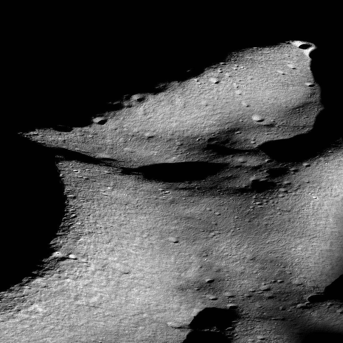
Cool image time! The photo to the right, reduced and annotated to post here, is an oblique view of the terrain near Shackelton Crater and the Moon’s south pole, taken by Lunar Reconnaissance Orbiter (LRO) and released today.
Shackleton-de Gerlache ridge, about 9 miles long, is considered one of the prime landing sites for both a manned Artemis mission as well as the unmanned Nova-C lander from the commercial company Intuitive Machines. To facilitate planning, scientists have created a very detailed geomorphic map [pdf] of this region. As explained at the first link above,
Going back to time-proven traditions of the Apollo missions, geomorphic maps at a very large scale are needed to effectively guide and inform landing site selection, traverse planning, and in-situ landscape interpretation by rovers and astronauts. We assembled a geomorphic map covering a candidate landing site on the Shackleton-de Gerlache-ridge and the adjacent rim of Shackleton crater. The map was derived from one meter per pixel NAC image mosaics and five meters per pixel digital elevation models (DEM) from Lunar Orbiter Laser Altimeter (LOLA) ranging measurements.
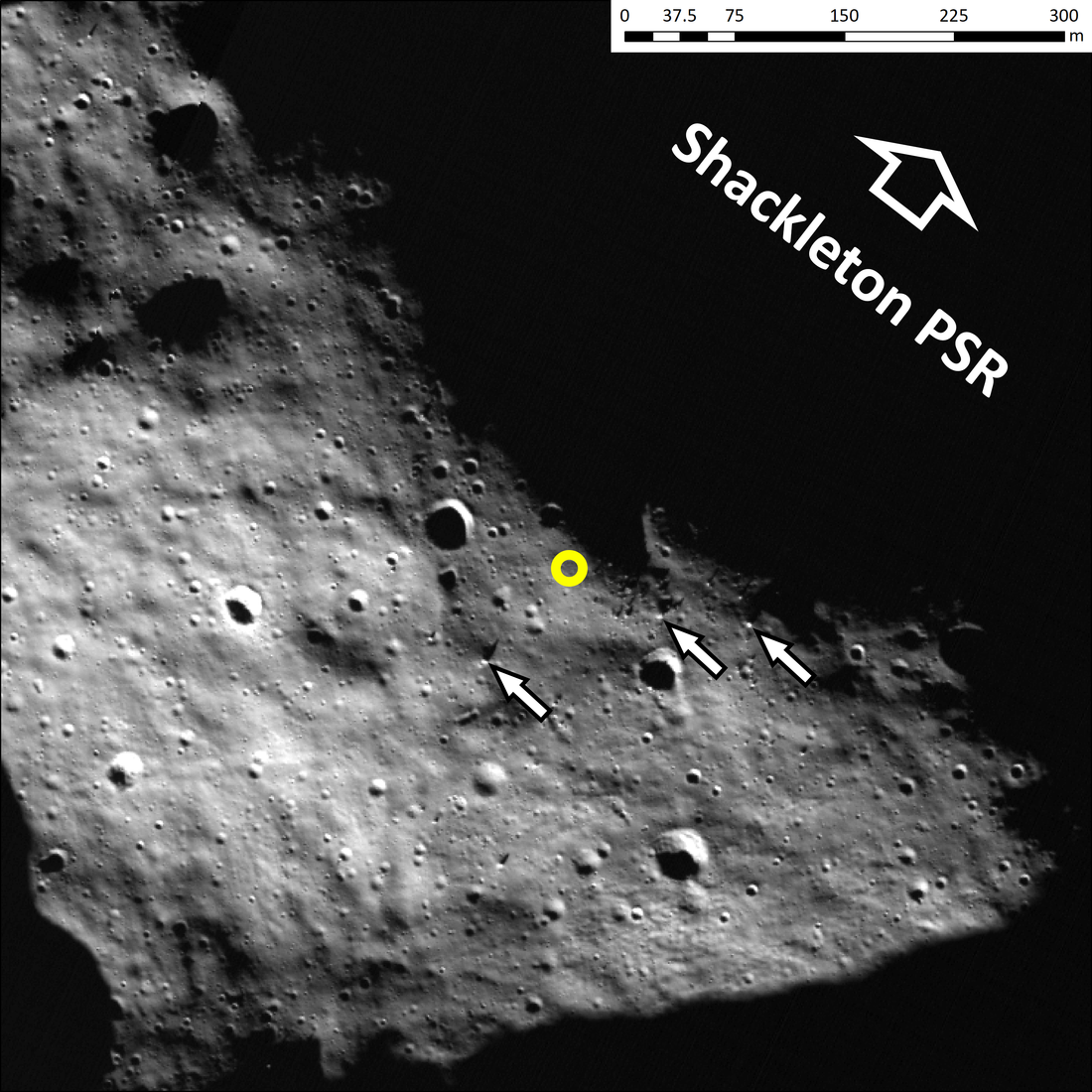
Such geology maps guide planning and exploration, but actual images tell us what the first explorers will see. Below is a close-up overhead view of small area at the intersection of the ridge and the rim of Shackleton.
Click for full image.
The white arrows point to boulders of geological interest. The yellow circle marks a very favored landing spot.
The white arrows point to larger (~8 m wide ) blocks that litter the surface and would be primary targets for geologic exploration. These blocks were likely ejected by the Shackleton impact event and might, thus, be pieces of lunar crust that could reveal the regional lithology, the age of Shackleton, and possibly also the age of the South Pole-Aitken basin. The yellow circle marks a relatively flat area that offers a direct line of sight onto the Shackleton crater floor. From this point, utilizing light reflected from the inner wall, a landed asset could conduct observations of the Shackleton PSR [permanently shadowed regions].
In other words, this flat spot is possibly at this time the most valuable piece of real estate on the Moon. From here a lander or human crew could make observations into Shackleton and determine in a number of ways whether there is ice in the crater’s permanent shadows.
Right now, the U.S. is probably in the lead to land here first, likely with Intuitive Machines’ Nova-C lander, tentatively scheduled for a launch late this year. The first manned mission, which NASA is likely planning for the third Artemis launch of SLS using Starship, will not happen any sooner than 2025, with a more likely launch in ’26 or later, or not at all. Another American option should SLS get delayed or fails would be to use SpaceX’s Starship/Superheavy entirely. The company is aiming to have this rocket/spaceship combo operational in the next two years.

On Christmas Eve 1968 three Americans became the first humans to visit another world. What they did to celebrate was unexpected and profound, and will be remembered throughout all human history. Genesis: the Story of Apollo 8, Robert Zimmerman's classic history of humanity's first journey to another world, tells that story, and it is now available as both an ebook and an audiobook, both with a foreword by Valerie Anders and a new introduction by Robert Zimmerman.
The print edition can be purchased at Amazon or from any other book seller. If you want an autographed copy the price is $60 for the hardback and $45 for the paperback, plus $8 shipping for each. Go here for purchasing details. The ebook is available everywhere for $5.99 (before discount) at amazon, or direct from my ebook publisher, ebookit. If you buy it from ebookit you don't support the big tech companies and the author gets a bigger cut much sooner.
The audiobook is also available at all these vendors, and is also free with a 30-day trial membership to Audible.
"Not simply about one mission, [Genesis] is also the history of America's quest for the moon... Zimmerman has done a masterful job of tying disparate events together into a solid account of one of America's greatest human triumphs."--San Antonio Express-News
First spot visited should be where Ed, Molly and the Seahawk landed.
We OWN the moon.
We’ve been there and planted our flag.
If the godless Chicom commies want to go to OUR moon they’ll have to ask our permission. And pay us rent.
As to being a flat spot, it looks relatively flat. But they do not tell us the resolution of the image. So, it is likely 1 meter/pixel. This means you cannot see <1m diameter objects. Likely even 1m are hard to see. Usually you need .5m/pixel to see 1m objects. Might be an issue for landing.
Also, the landing ellipse seems small. Do you even want to land that close to boulders? In fact, do you really want to land that close to a vast PSR? These are certainly robotic landers with automatic systems.
As to a direct line of site of the crater from that vantage, its not so easy unless you have a high lander. Maybe you can see the opposite floor of the crater. Certainly not the entire floor.
I think for the first landings, they will want to land not on the Shackleton Crater rim.
Is there truly any safe places to land on the moon? Any claim made to real estate cannot be done from earth, we have to go there to plant your own flag. (then defend it)
The danger just makes it more exciting, especially if mistakes are made and a workaround is performed to overcome unknown variables. This makes it inspirational, legendary… And Mr. Zimmerman will be the first to write about it. Humans are so resilient.
We own the moon? Ha Ha
Claims of “owning something” have to be backed up by force and legal documentation.
The world is currently in flux, the biggest bully will claim to own everything.
If ruthless enough, with the fire power and the right alliances to back their claims… They will prove that “might makes right” and everyone else will bow to them.
Like all empires, it won’t last long unless it’s built upon individual trust and responsibility like the constitutional american experiment. (which currently does not exist)
We’ve tipped over into a technological dark age were billionaire corporations and their public/private Nazi empires are fighting for dominance.
Elon musk is a wild card and has yet to choose sides as entire countries are maneuvering for their correct posture. (those given a choice anyway) This gives me hope.
Millions of pictures of the moon into a movie.
https://www.thisiscolossal.com/2022/04/andrew-mccarthy-moon-libration/
There are safer places to land than others. Larger landing ellipses or more than one alternate nearby landing sites. We are limited based on existing imagery. Better to land in light than in the dark.
Thinking a little more about it, the claim they make the little boulders they point out are from the original Shackleton Crater formation seems a dubious idea. More likely they came from some other subsequent impact.
While we can’t claim real estate, it will be a problem if someone lands there before us. They could claim the area around their lander or rover or tracks as historically significant, like we did for Apollo sites.
But claiming that a site is the “most valuable” is a little hard to do. The best way to see if ice is in a crater is to go there (put a lander/rover there for in situ data sampling), not use remote instruments from a crater rim.