Twisted and tilted bedrock in Martian crater
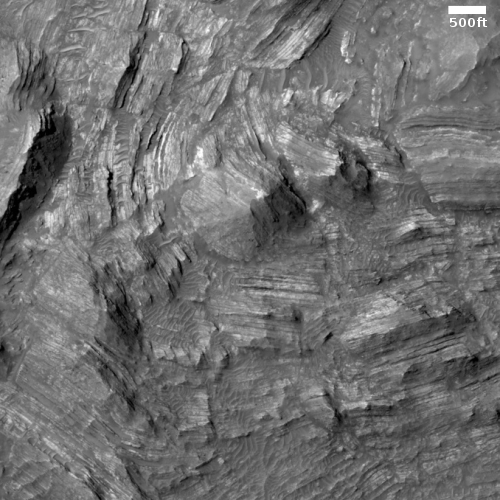
Cool image time! The photo to the right, rotated cropped, and reduced to post here, is only a small example of the strangely tilted and twisted strata in the central peak region of 38-mile-wide Martin Crater on Mars. The full image shows more.
The picture was taken on January 12, 2021 by the high resolution camera on Mars Reconnaissance Orbiter (MRO). The section I’ve cropped out shows a series of stratified strata that are are not only significantly tipped from the horizontal, but have also been bent and deformed.
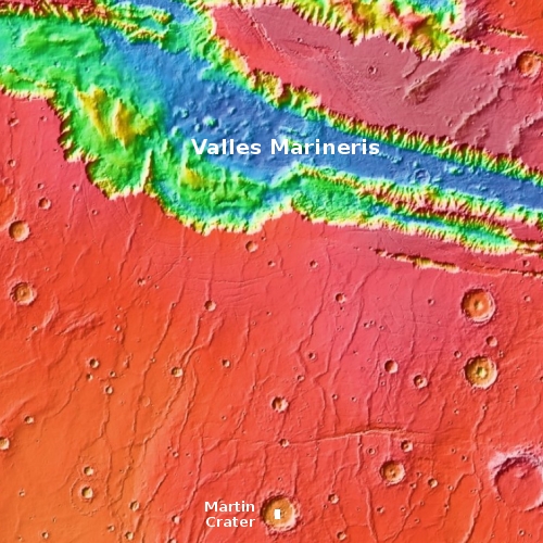
The crater itself is located about 260 miles south of Valles Marineris, as shown on the overview map below.

The white box in Martin Crater indicates the location of the above photo. It covers most of the central peak of this crater.
What caused these bedding planes to get tilted and twisted as we see them? And were they shaped this way before or after the impact that created the crater? The two features in the overview map that make me think these strata existed this way before the impact are the various north-south trending ridges and east-west cracks seen throughout this region. They suggest that this plateau south of Valles Marineris was at one point squeezed in an east-west direction, producing the ridges, as well as stretched in a north-south direction, producing the cracks. Such pushing and pulling could have also tilted and twisted the rock strata in Martin Crater.
Though this is a wild guess, it appears based on this paper on the geology of this region to be reasonable, though there remain many uncertainties and questions about that conclusion.
All we really know is that some big geological event in the far past reshaped this terrain, massively. The strata inside Martin Crater gives us an impressive peak at that event.
On Christmas Eve 1968 three Americans became the first humans to visit another world. What they did to celebrate was unexpected and profound, and will be remembered throughout all human history. Genesis: the Story of Apollo 8, Robert Zimmerman's classic history of humanity's first journey to another world, tells that story, and it is now available as both an ebook and an audiobook, both with a foreword by Valerie Anders and a new introduction by Robert Zimmerman.
The print edition can be purchased at Amazon or from any other book seller. If you want an autographed copy the price is $60 for the hardback and $45 for the paperback, plus $8 shipping for each. Go here for purchasing details. The ebook is available everywhere for $5.99 (before discount) at amazon, or direct from my ebook publisher, ebookit. If you buy it from ebookit you don't support the big tech companies and the author gets a bigger cut much sooner.
The audiobook is also available at all these vendors, and is also free with a 30-day trial membership to Audible.
"Not simply about one mission, [Genesis] is also the history of America's quest for the moon... Zimmerman has done a masterful job of tying disparate events together into a solid account of one of America's greatest human triumphs."--San Antonio Express-News
Cool image time! The photo to the right, rotated cropped, and reduced to post here, is only a small example of the strangely tilted and twisted strata in the central peak region of 38-mile-wide Martin Crater on Mars. The full image shows more.
The picture was taken on January 12, 2021 by the high resolution camera on Mars Reconnaissance Orbiter (MRO). The section I’ve cropped out shows a series of stratified strata that are are not only significantly tipped from the horizontal, but have also been bent and deformed.
The crater itself is located about 260 miles south of Valles Marineris, as shown on the overview map below.

The white box in Martin Crater indicates the location of the above photo. It covers most of the central peak of this crater.
What caused these bedding planes to get tilted and twisted as we see them? And were they shaped this way before or after the impact that created the crater? The two features in the overview map that make me think these strata existed this way before the impact are the various north-south trending ridges and east-west cracks seen throughout this region. They suggest that this plateau south of Valles Marineris was at one point squeezed in an east-west direction, producing the ridges, as well as stretched in a north-south direction, producing the cracks. Such pushing and pulling could have also tilted and twisted the rock strata in Martin Crater.
Though this is a wild guess, it appears based on this paper on the geology of this region to be reasonable, though there remain many uncertainties and questions about that conclusion.
All we really know is that some big geological event in the far past reshaped this terrain, massively. The strata inside Martin Crater gives us an impressive peak at that event.
On Christmas Eve 1968 three Americans became the first humans to visit another world. What they did to celebrate was unexpected and profound, and will be remembered throughout all human history. Genesis: the Story of Apollo 8, Robert Zimmerman's classic history of humanity's first journey to another world, tells that story, and it is now available as both an ebook and an audiobook, both with a foreword by Valerie Anders and a new introduction by Robert Zimmerman.
The print edition can be purchased at Amazon or from any other book seller. If you want an autographed copy the price is $60 for the hardback and $45 for the paperback, plus $8 shipping for each. Go here for purchasing details. The ebook is available everywhere for $5.99 (before discount) at amazon, or direct from my ebook publisher, ebookit. If you buy it from ebookit you don't support the big tech companies and the author gets a bigger cut much sooner.
The audiobook is also available at all these vendors, and is also free with a 30-day trial membership to Audible.
"Not simply about one mission, [Genesis] is also the history of America's quest for the moon... Zimmerman has done a masterful job of tying disparate events together into a solid account of one of America's greatest human triumphs."--San Antonio Express-News


This is certainly one of the best “cool images”, and surely a candidate for a “what the heck” image! I keep looking at the cliffs on the lower left of the full image, and then at the 90°inverted strata so close by…. And at so lower depth…. What the heck could cause such a massive distortion without destroying the strata? The distortions seem to have circular patterns, so probs crater related… But how? My only thought is perhaps relating to an ice and rock mix in the bedrock being more flexible than just pure rock? I can look at a sedimentary rock layer on earth and have a decent guess how it ended up that way…. Looking at this just makes me confused!!
Lee: Another explanation for this strata just occurred to me. If you look at the wider MRO context camera image (available here), it is clear that this feature is at the crater’s central peak, though that central peak appears to have been worn away.
Maybe we are seeing the base of that peak, the rest long gone because of wind and maybe even ice erosion. The vertical twisted strata we see would make sense for the central peak of an impact crater.