
Moon’s south pole permanently shadowed regions are younger than expected
Click for original image.
A new long range model of the Moon’s orbit and rotational tilt now suggests that the permanently shadowed regions (PSRs) in its south polar regions are much younger than previous predicted, which reduces the likely amount of ice that has been preserved there.
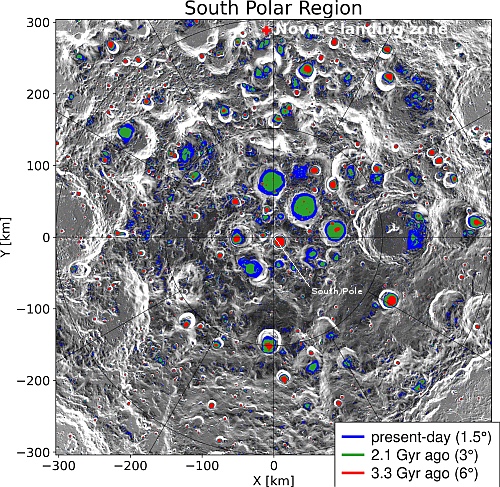
The map of the south pole region to the right, reduced, sharpened, and annotated to post here, shows the locations of those shadowed regions, with their predicted ages indicated by the colors (Gyr = billion years). Note that the Nova-C lander, planned for launch in mid-November, will land somewhat near some relatively young PSRs, as indicated by the red cross. From the press release:
“We calculated the lunar spin axis orientation and the extent of PSRs based on recent advances for the time evolution of the Earth-Moon distance,” he said. Early in its history, the Moon (which is 4.5 billion years old) was bombarded by comets and volcanism released water vapor from its interior, but continuously shadowed areas started to appear only 3.4 billion years ago. By that time these processes had started to die down, so most of the water that was delivered to the Moon or outgassed from its interior could not have been trapped in the polar regions. Any ice in the polar regions today must have a more recent origin.
“We have been able to quantify how young the lunar PSRs really are,” Schorghofer said. “The average age of PSRs is 1.8 billion years, at most. There are no ancient reservoirs of water ice on the Moon.”
Since other data suggests the presence of ice, it is possible that these reserves are regularly renewed by the arrival of impacts. It also suggests however that there might be less ice available than hoped. Above all, the red colored regions appear to be the most valuable real estate to explore first.
Note: The landing sites for both India’s Vikram lander and Russia’s Luna-25 lander were well beyond the map’s upper right edge, far outside the region where any permanently shadowed craters are located. The news outlets that talked about finding water or ice on either mission were simply illustrating their ignorance and sloppy reporting.

Click for original image.
A new long range model of the Moon’s orbit and rotational tilt now suggests that the permanently shadowed regions (PSRs) in its south polar regions are much younger than previous predicted, which reduces the likely amount of ice that has been preserved there.
The map of the south pole region to the right, reduced, sharpened, and annotated to post here, shows the locations of those shadowed regions, with their predicted ages indicated by the colors (Gyr = billion years). Note that the Nova-C lander, planned for launch in mid-November, will land somewhat near some relatively young PSRs, as indicated by the red cross. From the press release:
“We calculated the lunar spin axis orientation and the extent of PSRs based on recent advances for the time evolution of the Earth-Moon distance,” he said. Early in its history, the Moon (which is 4.5 billion years old) was bombarded by comets and volcanism released water vapor from its interior, but continuously shadowed areas started to appear only 3.4 billion years ago. By that time these processes had started to die down, so most of the water that was delivered to the Moon or outgassed from its interior could not have been trapped in the polar regions. Any ice in the polar regions today must have a more recent origin.
“We have been able to quantify how young the lunar PSRs really are,” Schorghofer said. “The average age of PSRs is 1.8 billion years, at most. There are no ancient reservoirs of water ice on the Moon.”
Since other data suggests the presence of ice, it is possible that these reserves are regularly renewed by the arrival of impacts. It also suggests however that there might be less ice available than hoped. Above all, the red colored regions appear to be the most valuable real estate to explore first.
Note: The landing sites for both India’s Vikram lander and Russia’s Luna-25 lander were well beyond the map’s upper right edge, far outside the region where any permanently shadowed craters are located. The news outlets that talked about finding water or ice on either mission were simply illustrating their ignorance and sloppy reporting.


