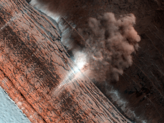
The touchdown that shook the Earth
The touchdown that shook the Earth.
The Krakatau volcano in Indonesia has become active, forcing the evacuation of tens of thousands residents.
Black gold! Three to four billion barrels of oil — 25 times more than previously predicted — are now thought to lie under certain geological formations in North Dakota and Montana.
In a paper published today in Geophysical Research Letters of the American Geophysical Union, scientists describe how they have been able to produce remarkably detailed images of the ground buried almost a mile under the ice sheet of Greenland. These radar techniques are the same used in the past by spacecraft to image the hidden surface of Venus, only far more sophisticated.
This image from the paper compares the radar image of the Greenland surface (on the left) to an photograph of a known surface feature in the Northwest Territories of Canada, produced thousands of years ago by the giant icesheets of the last Ice Age. Both are at the same scale, about a third of a mile across, and are looking at the surface at an oblique angle of about 45 degrees. With the radar-produced image on the left, sunlight is simulated as coming from the right, with the elevation increasing as the colors go from green (lowest) to yellow to brown to purple (highest).
The long grooves, generally 30 to 100 feet deep and extending sometimes several miles, are produced as the icesheet slides across the ground. In the radar image, however, these grooves are slowly being ground out now.
It is the resolution of this technique that is so exciting. That they can look through ice almost a mile thick and resolve objects that are only tens of feet across tells me that someday it will be possible for spacecraft to map the smallest features on the surface of Venus or Titan. More exciting, this suggests that the technology will one day exist to even map the unknown surface of gas giants like Jupiter or Saturn, and do it in breathtaking detail.
Yowza!
In its 14 mile multi-year trek to Endeavour Crater — now about half completed — the Mars rover Opportunity has stopped to take a short rest stop at a small crater.
The crater, dubbed “Santa Maria Crater” by the scientists who operater Opportunity, is about the size of a football field. What makes it especially interesting are the sharp rocks piled up on its rim, as they are probably debris ejected from the crater at impact. Since this material probably came from deep below the Martian surface, it is also likely to hold information about the Martian geological past, thereby making it a prime research site.
A scientist has made the first measurements of the strength at the Earth’s core of its magnetic field. What’s most fascinating is that he used the Moon and distant quasars to do it! First he used radio observations of the quasars to get very precise measurements of the Earth’s rotation axis and how the Moon was tugging at that axis and thus affecting its magnetic field. Then,
By calculating the effect of the moon on the spinning inner core, Buffett discovered that the precession makes the slightly out-of-round inner core generate shear waves in the liquid outer core. These waves of molten iron and nickel move within a tight cone only 30 to 40 meters thick, interacting with the magnetic field to produce an electric current that heats the liquid. This serves to damp the precession of the rotation axis. The damping causes the precession to lag behind the moon as it orbits the earth. A measurement of the lag allowed Buffett to calculate the magnitude of the damping and thus of the magnetic field inside the outer core.
Scientists have used data from Cassini to identify what they think are ice volcanoes on Titan. The two volcanoes, each about 3000 feet high, are located near the equator and appear to resemble the volcanoes on Earth, with a central crater on top of cone-like peak and finger-like flows coming down the sides from the crater. The lava here, however, is not molten rock, but water.
Why Arkansas? Since September 20, the small town of Guy, Arkansa, has experienced a swarm of 487 measurable earthquakes.
In a paper published today in Geophysical Research Letters of the American Geophysical Union, scientists note that the rise of giant volcanic caldara under Yellowstone National Park has slowed significantly since 2006 and since 2008 has actually subsided somewhat. Key quote from the paper:
Here we propose that as the caldera source continues inflating, the accumulated strain energy in the deformed crust could promote earthquakes with mechanisms such as hydrofracturing,, migration of magmatic fluids, and brittle fracturing of rocks. These events can subsequently depressurize the magmatic systems or release the accumulated strain energy, slowing the uplift or even influencing a change in motion to subsidence. In January 2010 the Yellowstone caldera experienced another large earthquake swarm at its northwestern boundary close to the location of the 1985 swarm. . . . In the following five months the caldera experienced the first overall subsidence since the inception of its uplift in 2004. This scenario is similar to that in 1985 where a reverse of caldera uplift to subsidence was temporally correlated with the largest observed Yellowstone earthquake swarm.
And damn, do I want to rappel into them!
This week’s release of images from the HiRISE camera on Mars Reconnaissance Orbiter included these spectacular photos of two deep pits, approximately 180 and 310 meters in diameter and located aligned with a series of depressions that suggest additional passages at their base.
The first image shows the pits in the context of the surrounding terrain. From the caption:
These pits are aligned with what appears to be larger, degraded depressions. The wispy deposit may consist of dark material that has been either blown out of the pits or from some other source and scattered about by the local winds.
The next two images are heavily processed close-ups of each pit in order to bring out the detail within. From the caption:
The eastern most and smaller of the two pits contains boulders and sediment along its walls and brighter aeolian dune sediments on its floor. The larger, western most pit contains sediment and boulders with faint dune-like patterns visible on the deepest part of the floor. Both pits have steep eastern walls and more gently sloped western walls that transition gradually into the pit floor. Steep resistant ledges containing boulders that overhang and obscure the pit floors form the eastern walls.
The eruption of Mount Merapi continues to build, with the death toll now over 150 and over 200,000 people displaced from their homes. Heavens, it might even cause President Obama to cancel his visit to Indonesia.
More on the continuing eruption of Mount Merapi in Indonesia. Key quote:
The Volcano Mitigation and Geological Disaster Agency warned of worse in store as magma pushed towards the surface from depths of 6-8km, compared with a maximum 2km deep when the mountain previously erupted in 2006. “This is the scenario I dislike the most, because the deepest magma is pushing up now,” said the agency’s chief, Surono. “The eruptions haven’t stopped, the tremors are getting stronger and one big explosion could be the result. I’ve never seen it act like this. We don’t know what to expect.”
The worst volcanic eruption of Mount Merapi in Indonesia in a century has gotten worse.
Another Iceland volcano eruption pending? Iceland’s largest glacier, which sits atop the island’s largest volcano, Grimsvotn, began releasing large amounts of melt water on Thursday, October 25, indicating the volcano underneath might be heating up.
Evidence of subsurface water has been found by the Mars rover Spirit at the location where the rover remains stuck.
Bad news from Indonesia: A tsunami killed 108 at the same time a volcano eruption has forced thousands to flee.
Scientists have detected Venusian lava flows possibly only decades old.
Two German radar mapping satellites, flying in orbital formation, are now about to produce the first three-dimensional radar imagery of Earth. Key quote:
The combined mission’s data will produce gridded maps with a spatial resolution of 12 meters, or 39 feet. The maps will show elevation with a precision of less than 2 meters, or 6 feet.
Mars Reconnaissance Orbiter has taken this image of what appears to be a recent landslide on Mars, located on the southeast wall of Zunil crater. When the landslide took place is not known, though the color suggests that it happened so recently that the debris has not yet been covered by wind-blown dust.
The discovery by scientists of carbonate rock deep below the Martian surface suggests the planet once had a rich carbon dioxide atmosphere. It also suggests that conditions might be more habitable for life deep underground.
The plumes that come out of the tiger stripe cracks on Saturn’s moon Enceladus may be carbonated!
More results from the press conference going on right now at the 42nd meeting of the AAS Division for Planetary Sciences:
Pluto’s surface ice is made up of 97% nitrogen, 3% methane, while the surface of the Kuiper Belt object Eris (which is larger than Pluto) is even more rich in methane, with a make up of 90% nitrogen and 10% methane. Both measurements go down to a depth of about 10 inches. To see the abstract for this result, go here.
From a session today at the 42nd meeting of the AAS Division for Planetary Sciences: After thirteen years of searching, scientists have concluded that Mars has no active volcanic activity, including geysers, anywhere on its surface.
The HiRise Camera on Mars Reconnaissance Orbiter has released some wonderful new pictures, showing what are called barchan dunes on Mars.
Barchans are crescent-shaped, with the horns of the crescents pointing downwind. One barchan is visible in the upper part of the image, with the Southeast (lower right) horns longer than the other. This trend, along with the position of the steep face of the dune on the South side, indicates that the predominant winds which formed the dunes came from the North.
There are a lot more great images on the websites above.
A very detailed update on the trapped Chilean miners, now expected to be rescured in early November. Two key quotes:
The miners are sleeping on cots that were sent down in pieces and reassembled, and each can look forward every weekend to eight minutes each of video chat time with his family using compact cameras and a phone that was disassembled to fit through the hole.
And:
Their routine starts with breakfast – hot coffee or tea with milk and a ham-and-cheese sandwich. Then lots of labor: Removing the loose rock that drops through the bore holes as they are being widened into escape tunnels; cleaning up their trash and emptying the toilet; and attending to the capsules known as “palomas” – Spanish for carrier pigeons – that are lowered to them with supplies.
The miners must quickly remove the contents – food, clean clothes, medicine, family letters and other supplies – and send back up material such as dirty clothes, rolled up like sausages to fit. Each trip down takes 12 to 15 minutes, then four minutes for unloading and five minutes to pull them back up. At least three miners are constantly stationed at the bore hole for this work.