
Ingenuity’s last flight: an accident investigation
Click for original image.
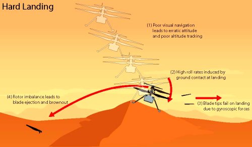
Using all the data available, engineers at JPL have done a more detailed accident investigation into Ingenuity’s last flight on Mars on January 18, 2024, and are about to publish their report. Their conclusions however were published today by NASA, with the graphic to the right the main conclusion.
One of the navigation system’s main requirements was to provide velocity estimates that would enable the helicopter to land within a small envelope of vertical and horizontal velocities. Data sent down during Flight 72 shows that, around 20 seconds after takeoff, the navigation system couldn’t find enough surface features to track.
Photographs taken after the flight indicate the navigation errors created high horizontal velocities at touchdown. In the most likely scenario, the hard impact on the sand ripple’s slope caused Ingenuity to pitch and roll. The rapid attitude change resulted in loads on the fast-rotating rotor blades beyond their design limits, snapping all four of them off at their weakest point — about a third of the way from the tip. The damaged blades caused excessive vibration in the rotor system, ripping the remainder of one blade from its root and generating an excessive power demand that resulted in loss of communications.
The reason Ingenuity’s system couldn’t find enough features to track was because it was flying over a dune field, the ground almost all smooth sand. The only features were the soft changes of topography caused by the dunes, which were not small.
Not surprisingly, these same engineers are working on a larger drone-type helicopter for a future mission, dubbed Mars Chopper, which based on an short animation released by NASA, is the mission targeting Valles Mariner that I first described in June 2022. The investigation into Ingenuity’s failure will inform the design of Chopper.

Click for original image.
Using all the data available, engineers at JPL have done a more detailed accident investigation into Ingenuity’s last flight on Mars on January 18, 2024, and are about to publish their report. Their conclusions however were published today by NASA, with the graphic to the right the main conclusion.
One of the navigation system’s main requirements was to provide velocity estimates that would enable the helicopter to land within a small envelope of vertical and horizontal velocities. Data sent down during Flight 72 shows that, around 20 seconds after takeoff, the navigation system couldn’t find enough surface features to track.
Photographs taken after the flight indicate the navigation errors created high horizontal velocities at touchdown. In the most likely scenario, the hard impact on the sand ripple’s slope caused Ingenuity to pitch and roll. The rapid attitude change resulted in loads on the fast-rotating rotor blades beyond their design limits, snapping all four of them off at their weakest point — about a third of the way from the tip. The damaged blades caused excessive vibration in the rotor system, ripping the remainder of one blade from its root and generating an excessive power demand that resulted in loss of communications.
The reason Ingenuity’s system couldn’t find enough features to track was because it was flying over a dune field, the ground almost all smooth sand. The only features were the soft changes of topography caused by the dunes, which were not small.
Not surprisingly, these same engineers are working on a larger drone-type helicopter for a future mission, dubbed Mars Chopper, which based on an short animation released by NASA, is the mission targeting Valles Mariner that I first described in June 2022. The investigation into Ingenuity’s failure will inform the design of Chopper.


