Martian ridge sticking up out of a lava flood plain

Martian ridge sticking up out of a lava flood plain
Click for full image.

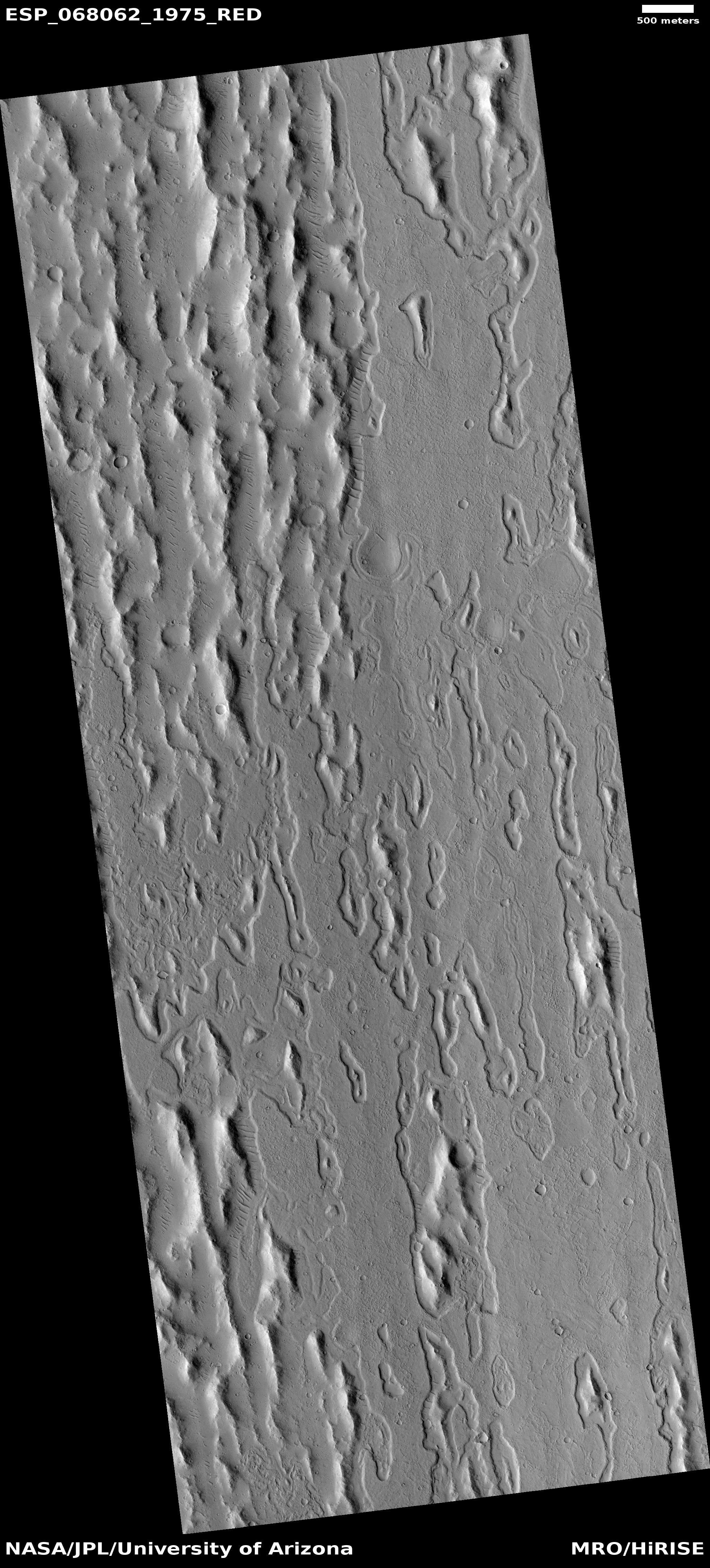
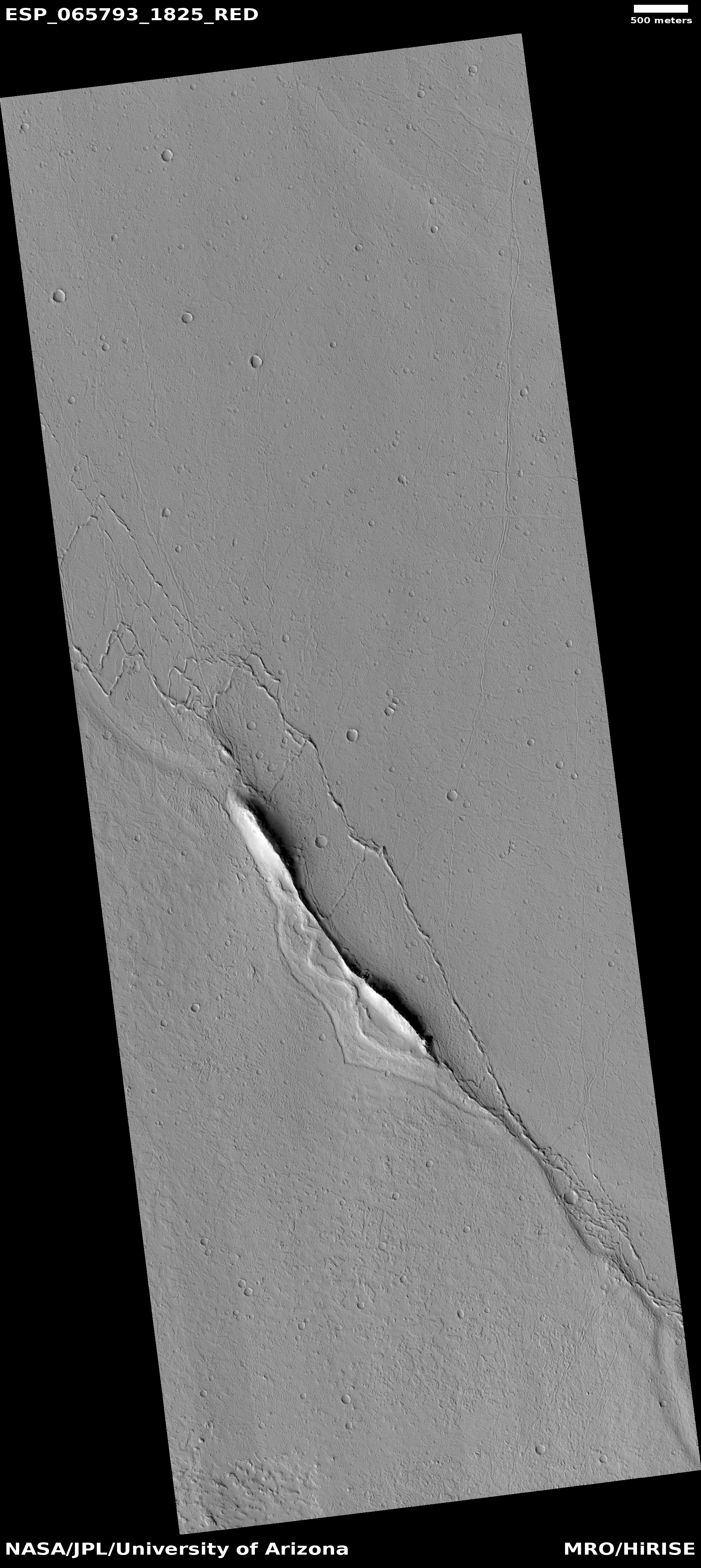
Cool image time! The photo to the right, rotated, cropped, and reduced to post here, was taken on August 9, 2020 by the high resolution camera on Mars Reconnaissance Orbiter (MRO) and was featured today as this camera’s picture of the day. As today’s caption notes:

This observation focuses a ridge that is standing above the old lava surface of the floor of Echus Chasma. What is this ridge doing here? Is it preexisting material surrounded by lava? Is it material pushed up at a restraining bend? If the ridge is not lava, it may have colorful flanks.

The overview map below shows that this location in Echus Chasma is even more interesting, as some scientists believe it once also held a large lake.
» Read more

A Mars mesa carved by floods and lava?

Overview map of Kasei Valles

With today’s cool image we once again start our journey from afar, and zoom in. The overview map to the right focuses in on the thousand-mile-long Kasei Valley on Mars.

The blue area is where scientists postulate a lake once existed, held there by an ice dam (indicated by the white line). At some point that ice dam burst, releasing the water in a catastrophic flood that created the braided flow features that continue down Kasei Valles to the northern lowland plain of Chryse Planitia.

The black area marks a giant lava flow that scientists believe came later, following the already carved stream channels for a distance of 1,000 miles, traveling at speeds of 10 to 45 miles per hour.

The red dot near the Kasei Valles resurgence is today’s cool image.
» Read more

A river of lava on Mars as long as the Columbia

Lava flow in Kasei Valles
Click for full image.

I’ve said it before and I’ll say it again. Mars is strange, Mars is wonderful, but above all, Mars is alien. Today’s cool image illustrates this saying quite nicely.

The photo to the right, cropped and reduced to post here, was taken on February 1, 2021 by the high resolution camera on Mars Reconnaissance Orbiter (MRO) and was simply labeled “Sacra Sulci Lava”. Sacra Sulci is a section of the Kasei Valles canyon that runs from the north rim of Valles Marineris north about 600 miles where it turns east for about 400 miles to drain out into the northern lowlands plains of Mars. Sacra Sulci is the region where that valley narrows and then turns east.

Apparently the flat smoother areas on the east and south on this image that rise about 60 feet above the surrounding terrain and that also seem to flow around mesas and into canyons are believed to be the edge of a massive lava flow that occurred about 150 to 200 million years ago and drained through Kasei Valles, just like water.

What makes this puzzling, however, is that everything I had read previously about Kasei Valles said that it was thought to have been formed from catastrophic floods of water on early Mars, when the planet was warmer and wetter. In fact, I had posted previously about this theory, and included the map below, taken from figure 8 of this paper [pdf], showing part of the process that some scientists believe occurred.
» Read more

Another “What the heck?!” image on Mars

A
Click for full image.

Today’s cool image, taken on September 2, 2020 by the high resolution camera on Mars Reconnaissance Orbiter (MRO) and cropped and reduced to post here, is one that I will make very little attempt to explain. It falls into a category I call “What the heck?!” The uncaptioned website labels this “Ringed Ridges in Kasei Valles”, which merely describes what we see.

This isn’t an impact crater. The rings don’t fit any morphology I’ve ever seen for such features.

Could we be looking at some type of glacial feature? The latitude, 29 degrees north, makes this unlikely but possible. Even so, it sure doesn’t look like it. The ripples in the center and between the ridges are sand dunes, not glacial features.

Might this be a volcanic vent, with the concentric ridges marking multiple eruptions? Maybe, but if so I’ve never seen any volcanic vent or caldera that looked quite like this.

The overview map below gives some context, but hardly explains anything.
» Read more

Was there a catastrophic flood in Kasei Valles on Mars?

Overview map of lower section of Kasei Valles

Figure from paper

In our on-going exploration of Mars using the amazing high resolutions being taken by Mars Reconnaissance Orbiter (MRO), we return today to Kasei Valles, the drainage valley coming down from Mars’ giant volcanoes that I featured only a few days ago. And like that post, we must begin from afar and zoom in to understand what we are seeing in the final cool image.

Kasei Valles is a canyon system is about 1,900 miles long, and would cover two-thirds of the continental United States if placed on Earth. Its north-trending upstream section to the west and south of the area shown on the overview map to the right is thought to have been formed by some combination of glacial and volcanic processes. The downstream west-east section shown in the map instead appears to have been formed by a sudden catastrophic flood, which some scientists have theorized [pdf] occurred when a three hundred long ice dam broke suddenly, releasing the flood quickly across this terrain to create its features. The second map to the right, from their paper, illustrates this hypothesized event.

The white box in 60-mile wide Sharonov Crater near the center of the first map above indicates the location of today’s cool image below. The 1976 landing site of VIking 1 about 420 miles to the east is also indicated.

If you look closely at the first overview map above you can see that the rim of Sharonov Crater appears breached in its southwest quadrant, just to the west of the white box. This breach is less a break and more an area of increased erosion. Regardless, it sure appears that a massive flow pushed through the rim here.
» Read more

The edge of Martian chaos

Overview map of end of Kasei Valles

For today’s cool image, we are going to start from afar and zoom in, because I think that might be the best way to gain at least a rudimentary understanding of the strange geology visible at this one particular Martian location.

The first image, to the right, is the overview map. The red cross indicates our target, a chaotic canyon that flows into the larger Kasai Valles, one of Mars’ largest and longest canyons and possibly only exceeded in size by Valles Marineris. This part of Kasai is near its end, where it drains out into the vast northern lowland plains of Mars.

The second image, below, comes from the wide angle camera on Mars Reconnaissance Orbiter (MRO).
» Read more

A great hike to do on Mars!

Knife Mesa at the exit from Kasei Valles
Click for full image.

Time to take a cool image and go sight-seeing. The photo to the right, cropped and reduced to post here, was taken by the high resolution camera on Mars Reconnaissance Orbiter (MRO) on May 25, 2020, and shows a spectacular knife-edge mesa, its cliffs more than 650 feet high on either side.

This knife mesa sits among a bunch of similar mesas, and appears to be in a region that could be called chaos terrain, formed by flowing water or ice along faults, cutting criss-crossing canyons with mesas between.

This mesa points east out from the Kasei Valley, the second largest canyon draining out from the Tharsis Bulge that contains Mars’ largest volcanoes. The overview map below provides some context, with the white cross indicating the location of today’s cool image.
» Read more

Enigmatic layering and chasms on Mars

Enigmatic layering and chasms
Click for full image.

Overview map

Cool image time! The photo to the right, rotated, cropped, and reduced to post here, was taken on April 28, 2020 by the high resolution camera on Mars Reconnaissance Orbiter. (MRO). The science team entitled it “Enigmatic Uplifts in Echus Montes,” indicating a sense of bafflement on their part about this geology.

The features here are certainly somewhat puzzling. At first glance the terrain is reminiscent of Martian chaos terrain, mesas cut by canyons in an almost random pattern. As I explained at the link,

Chaos terrain is typically a collection of mesas separated by straight-lined canyons. It is found in many places on Mars, most often in the transition zone between the southern highlands and the northern lowlands where an intermittent ocean might once have existed. It is believed to form by erosion, possibly caused by either flowing water or ice, moving along fault lines. As the erosion widened the faults, they turned into canyons separating closely packed mesas. With time, the canyons widened and the mesas turned into a collection of hills.

What makes this particular image puzzling however is that there seem to be multiple layers of mesas and canyons. Look at the top of the rectangular mesa in the upper middle of the image. It appears to have its own miniature chaos terrain on its plateau. Somehow that first layer of chaos was abandoned when the more prominent larger canyons started to form around it.

The location of this feature is indicated by the black cross on the overview map to the right. It is in the middle of the large and wide northward trending part of the giant valley dubbed Kasei Valles. And as usual, knowing the location helps explain what we are seeing.
» Read more