Cracked bedrock on Mars?

Cracked Martian landscape
Click for full image.

For today’s cool image we return to Mars. The picture to the right, cropped and brightened to post here, was taken on December 3, 2025 by the high resolution camera on Mars Reconnaissance Orbiter (MRO).

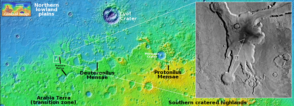
The focus of the picture was a strange crater in the floor of Mawrth Vallis, a channel that drains northward from Mars’ cratered southern highlands to its northern lowland plains. You can see the crater in the full image if you click on the picture. It is intriguing because its rim is strangely abrupt and flat on all sides, something that is not seen with impact craters, which have a raised rim of material plowed out by the impact.

In the picture to the right I have however focused on the two small 50-70-foot-high mesas and cracked ground that surrounds them. What struck me was the dry appearance of this landscape. Located at 23 degrees north latitude, it is in the dry tropics of Mars, where little near surface ice is found. The cracks emphasize this conclusion, as they so well resemble the cracks you see in dried mud on Earth.
» Read more

2 comments

Curiosity looks uphill at its upcoming travels

Panorama looking up Mount Sharp
Click for original.

Overview map
Click for interactive map.

Cool image time! Since May 2025 Curiosity has been exploring in great detail the boxwork formations located on the lower slopes of Mount Sharp. It is now about to complete those investigations, with the Curiosity science team beginning their planning for moving onward and upward.

The panorama above, enhanced to post here, was taken on March 2, 2026 by the rover’s right navigation camera. It looks uphill along the valley that Curiosity is in toward the mountainous region the rover is targeting. Note that the peak of Mount Sharp is not visible, being more than 25 miles away beyond the horizon and about 15,000 feet higher up.

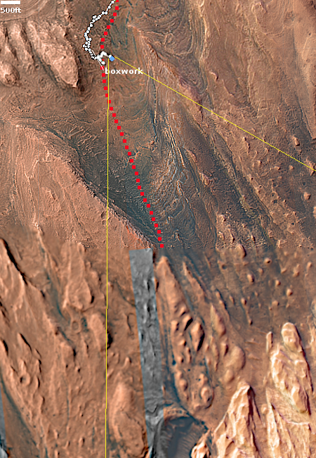
The blue dot on the overview map to the right mark Curiosity’s present position. The yellow lines indicate roughly the area this panorama covers. The red dotted line marks the rover’s approximate planned route, while the white dotted line indicates Curiosity’s actual travels.

Right now Curiosity is traveling through a geological layer the scientists have dubbed the sulfate unit. The lighter colored hills seen on the horizon have also been identified as sulfate, but believed to be much more pure. The geology there should be very different. Instead of rough and rocky it could be like traveling over soft porous sand. This however is merely a guess on my part, based on imagery of those light-colored hills.

The actual route through those hills however remains unknown. Either the science team has not yet released it, or is still trying to figure out the best way through.

2 comments

Mars’ fast moving gigantic lava floods

A Martian crater broken by flowing lava
Click for original image.

Cool image time! The picture to the right, rotated, cropped, and reduced to post here, was taken on December 12, 2025 by the high resolution camera on Mars Reconnaissance Orbiter (MRO).

The science team labels this a “crater interrupted by flow.” And what a flow! This unnamed 1.4-mile wide crater was not only filled and partly buried by the flow, that flow was so strong it cut through the crater’s rim at two points, refusing to let that rim block it in any way.

The flow in this case is lava, coming down from the Tharsis Bulge where four of Mars’ biggest volcanoes arose. And that flow was quite vast, as the nearest of those volcanoes, Arsia Mons, is almost 800 miles away. Because of Mars’ relative light gravity, about 39% that of Earth’s, lava on Mars can flow across large distances in a very short time. It might have only taken a few weeks for that flow to cover that 800 miles.
» Read more

7 comments

The weird landscape of Mars’ death valley

Taffy terrain
Click for original image.

Cool image time! The picture to the right, rotated, cropped, reduced, and enhanced to post here, was taken on October 28, 2025 by the high resolution camera on Mars Reconnaissance Orbiter (MRO).

The science team labels this “bands near mesa,” an apt description. What we are looking at is a geological feature unique to Mars, but also unique to only one particular place on Mars, the planet’s death valley, the place in Hellas Basin with the lowest relative elevation of any spot on Mars.

The feature is called taffy terrain. According to a 2014 paper, the scientists posit that this material must be some sort of “a viscous fluid,” naturally flowing downward into “localized depressions.” Those localized depressions however happen to also be at the very basement of Mars.

Note how in some spots the bands appear to have been stripped off, exposing small hollows in which dust has become trapped over time to form ripple dunes.
» Read more

1 comment

A sinuous Martian ridge of uncertain origin

A sinuous ridge of uncertain origin
Click for original image.

Cool image time! The picture to the right, rotated, cropped, reduced, and sharpened to post here, was taken on July 21, 2025 by the high resolution camera on Mars Reconnaissance Orbiter (MRO). It was posted today by the camera team as a captioned image, with the caption as follows:

The sinuous ridge is approximately 10 meters wide and several kilometers long. The floor surrounding this ridge has been eroding laterally, forming pits and circular features suggestive of removal (sublimation) of subsurface ice. However, landforms such as channels or moraines that might suggest the presence of water or ice are lacking, so the ridge itself does not appear to have formed by fluvial or glacial processes.

Perhaps this curious feature is an exhumed dike formed from magma emanating from Alba Mons in subsurface fractures.

Alba Mons is a gigantic shield volcano to the west.
» Read more

1 comment

A sculptured Martian landscape

Weird Martian landscape
Click for original.

Cool image time! The picture to the right, cropped and sharpened to post here, was taken on December 4, 2025 by the high resolution camera on Mars Reconnaissance Orbiter (MRO).

The science team labels this landscape “olivine-rich plains”, which is a magnesium iron silicate mineral of some industrial value that is quite common on Earth. Its presence here suggests there could be other valuable minerals in this region.

I post the image because the landscape is so weird and beautiful. The orange color suggests these ridges are covered with dust, if not made of dust entirely. The small areas with a greenish tint that appear to mostly appear on north-facing cliffs could be frost, except this is in the southern hemisphere where north-facing cliffs get more sunlight. As it was autumn when this picture was taken frost is an unlikely explanation.

More likely the green indicates exposures of bedrock or coarser boulders.
» Read more

3 comments

Windswept Martian volcanic ash?

Volcanic ash on Mars?
Click for original image.

Cool image time! The picture to the right, rotated, cropped, reduced, and sharpened to post here, was taken on November 30, 2025 by the high resolution camera on Mars Reconnaissance Orbiter (MRO).

The science team labels this simply as “Features,” the vagueness of which I can understand after digging in to get a better idea of the location and geography.

The location, as shown by the white dot on the overview map below, is inside the Medusa Fossae Formation, the largest volcanic ash field on Mars that is thought to be the source of much of the red planet’s dust. That ash field is large and very deep, and was put down more than a billion years ago when the giant volcanoes of Mars were active and erupting. Thus it is well layered, and many images of that ash field show that layering exposed by the eons of Martian wind scouring its surface.

In this case, that scouring appears to have produced this feathery surface, though the origin of those ridges might have instead come from volcanic flows that are now hardened. Or we could be looking at ancient channels produced by ice or water, though that would have to have been a very long time ago, as this image is located in the Martian dry tropics, where no near surface ice presently exists.
» Read more

0 comments

New gullies on Mars?

Fresh gullies on Mars?
Click for original image.

Cool image time! The picture to the right, cropped and reduced to post here, was taken on November 6, 2025 by the high resolution camera on Mars Reconnaissance Orbiter (MRO).

The science team labels this image “Fresh-Looking Gullies.” It was clearly taken to study the gullies flowing down the north interior crater wall of this 4.4 mile-wide unnamed crater, about 1,500 feet deep.

What causes these gullies remains an open question. They are found in many places in the Martian mid-latitudes. When first discovered scientists thought they might be related to the sublimation of underground ice. More recent research suggests they are formed by the seasonal dry ice frost cycle that in the high latitudes has carbon dioxide condense to fall as snow in autumn and then sublimate away in the spring.
» Read more

2 comments

Communications resume with Mars

First images back from Curiosity and Perseverance
Go here and here for the original images.

It appears the solar conjunction that has blocked all communications with the rovers and orbiters for the past three weeks around Mars has now fully ended, with the first new images appearing today from both Curiosity and Perseverance.

The two images to the right were downloaded today. The top image was taken on January 20, 2026 by Curiosity’s front hazard avoidance camera. It appears to be looking uphill in the direction the rover is soon to travel, climbing Mount Sharp. If you look closely you can see the mountain’s higher ranges on the horizon, just to the right of the rover itself.

The bottom picture was actually taken on January 15, 2026 by Perseverance, but was only downloaded today. Both science teams had programmed their rovers to take images throughout the conjunction, scheduled for download when communications resumed.

The picture was taken by Perseverance’s left high resolution camera located on top of the rover’s mast. It looks down at the ground near the rover at the pebbles and rocks that strewn the relatively smooth surface of the terrain west of Jezero crater.

Neither image is particularly ground-breaking. What is important however is that both images prove the rovers are functioning as expected. Expect a lot more data to arrive in the next few days, all gathered during three weeks of blackout.

4 comments

A 10-mile-long avalanche on Mars

Overview map

A ten mile long avalanche on Mars
Click for original image.

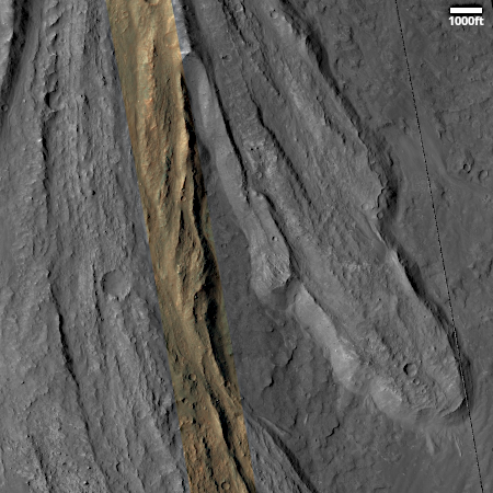
Cool image time! The picture to the right, cropped, reduced, and sharpened to post here, was taken on November 8, 2025 by the high resolution camera on Mars Reconnaissance Orbiter (MRO). It shows only three miles of a ten-mile-long avalanche inside the solar system’s largest canyon, Valles Marineris.

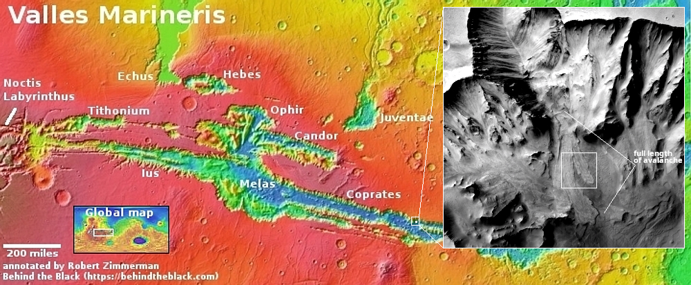
The white dot on the overview map above marks the location. In the inset the white rectangle indicates the area covered by the picture to the right. I have indicated the avalanche’s full extent beyond this.

Overall, the landslide fell about one mile along those ten miles. That there are about a dozen small craters on top of the slide tells us this happened quite a long time ago.

As always, the scale of Valles Marineris boggles the mind. Though this avalanche fell about 5,000 feet (the same depth of the south rim of the Grand Canyon), that drop only covered one fifth of Valles Marineris’s depth. At this point, from the rim to the floor the elevation difference is about 23,000 feet, which would place the rim among the 100 highest mountains on Earth. And of course, this is only one small spot in this gigantic canyon that runs 2,500 miles east-to-west, with its depth about the same that entire length.

1 comment

Mars Reconnaissance Orbiter’s high resolution camera is showing its age

More data drop-outs from MRO

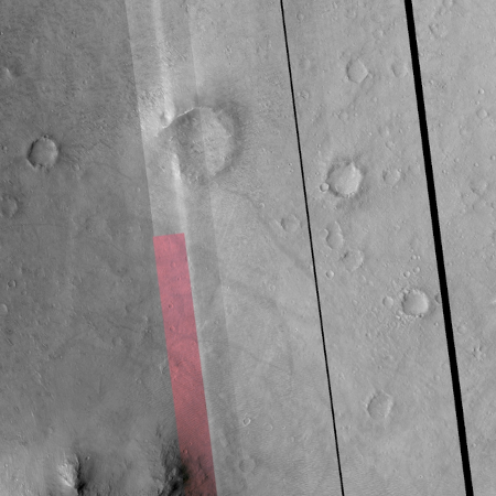
In a cool image earlier this week I noted that, in going through the archive of images most recently sent back from Mars Reconnaissance Orbiter’s (MRO) high resolution camera, it appeared the camera was exhibiting more anomalies, and that we must therefore “be prepared for the loss of this camera and orbiter in the somewhat near future.”

In reviewing the archive again yesterday I noticed even more evidence of deterioration, as illustrated by the picture to the left. Not only are there blank vertical strips of no data, but the color drops out of the color strip halfway down, something I had never seen before. Nor was this the only picture with these issues.

I decided to email Alfred McEwen of the Lunar & Planetary Laboratory in Arizona. who until recently had been the camera’s principal investigator, to find out what is really going on. His answer:

Yes, HiRISE is getting old, just like us. There are 2 issues:

  • 1. Sometimes RED4 fails, leaving a gap in the RED products and color.
  • 2. Bit flips create bad pixels (zeros) in RED1_1 and RED3_1. This can still be mitigated by raising electronics temperatures, and we were just approved for an increase, so this problem should soon be reduced for a year or two. One problem with these increased temperatures is that our calibration isn’t correct, leading to the stripe-ing and strange colors that you noted, although dusty air can also create such issues. The calibration will eventually get updated, but funding is extremely tight.

The first issue explains the drop-out in the color strip. This appears to be a relatively new problem.

The second issue explains the two additional black strips to the right of the color strip. (Bit flips are cases where the radiation of space causes a binary bit to flip randomly from 0 to 1, or visa versa.) Bit flips are something engineers expect in spacecraft, but it appears on MRO they are occurring with more and more frequency.

A third issue, the failure of the electronics unit for CCD RED4 that occurred in August 2023, causes a loss of data in the color strip (see the b&w version of the image above for an example), which the camera team has compensated for using other color filters in that area.

According to McEwen, while the team seems confident the increased temperatures, combined with re-calibration, will fix or reduce issue #2, it is less confident about its impact on the camera’s lifespan.

We wish we knew. We’ve raised temperatures many times and it still works, so we keep raising temperatures incrementally just in case.

All in all, however, McEwen says he expects the high resolution camera to be able to produce images for at as long as MRO operates (at least a decade more), though with time we might be finding the images become narrower and narrower strips.

1 comment

Martian glacier flowing past small peak

Overview map

Martian glacier flowing past small peak
Click for original image.

Cool image time! The picture to the right, rotated, reduced, and sharpened to post here, was taken on November 24, 2025 by the high resolution camera on Mars Reconnaissance Orbiter (MRO).

As is proper, the science team labels this vaguely as a “flow obstacle in lobate debris apron.” The obstacle is that small peak. The lobate debris apron is the material flowing past, resembling in almost all details what a glacier looks like on Earth. The scientists use vague terms because they don’t want to trap themselves into a conclusion before it is confirmed.

Nonetheless, based on all the data MRO and other Mars orbiters have been gathering for the past decade, we are almost certainly looking at near-surface ice flowing downhill and past that peak.

The white dot in the overview map above marks the location, on the western end of the 2,000-mile-long mid-latitude strip I label “glacier country,” because practically every image from this region shows features such as this.

The arrow in the inset shows the direction of the downhill grade, dropping from 2,000 to 3,000 feet from the surrounding plateau. The peak itself rises about 130 feet above the flow on the uphill side, but 650 feet above on the downhill side. Apparently the flow piled up somewhat as it hit the peak.

That flow however is likely inactive at this time. Though the researchers have repeatedly monitored the many glacial flows they have found on Mars in the decade since MRO arrived in Mars orbit, so far I have heard of no example showing any movement. And that covers about five Martian years.

These images do prove one thing: Mars is not dry. It has plenty of water near the surface, though locked in ice.

2 comments

Exposed weirdness on floor of Martian crater

Crazy shapes on floor of Martian crater
Click for original image.

Cool image time! The picture to the right, rotated, cropped, reduced, and sharpened to post here, was taken on November 27, 2025 by the high resolution camera on Mars Reconnaissance Orbiter (MRO).

The science team labels this “exposed crater floor materials”. While properly vague, that hardly suffices. This image could easily fall into my “What the heck?!” category of Martian geology that is difficult to understand, no less explain.

The color strip suggests that dust dominates near the top and bottom, though dust is also present in the middle. The patches with the bluish tint in the middle suggests these lighter swirls and patches are bedrock.

Of course, none of that explains the weird shapes of these patches, nor why they exist at all.

Before delving into those weird shapes, we must note the two vertical black strips to the right of the color strip, indicating a gap in data. Such gaps have been appearing more frequently of late, suggesting MRO’s age, almost a decade in orbit around Mars, is beginning to show itself. A failure in 2023 in one filter band of the high resolution camera already leaves blank the color swath in black and white images. These new blank strips indicate further issues, warning us that we must be prepared for the loss of this camera and orbiter in the somewhat near future.
» Read more

0 comments

New research supports theorized intermittent ocean exiting Mars’ giant Valles Marineris canyon

Theorized ocean from 2019 & 2022 papers

Scientists studying the deltas of debris that exist at the base of the cliffs inside Mars’ giant Valles Marineris canyon have concluded the deltas suggest the existence of an ocean there about three billion years ago.

The theorized ocean on the map to the right comes from research published in 2019, with additional support published in 2022. This new work supports those conclusions. From the press release:

At the lower end of the canyon system, so-called “scarp-fronted deposits” were discovered, which are interpreted as “fan deltas”. Fan deltas form where a fan-shaped cone of debris and sand grows directly into a standing body of water. The researchers found that the structures mapped on Mars are very similar to classic deltas on Earth.

…The results also show that the ocean found was at least as large as the Arctic Ocean on Earth. Schlunegger says: “We are not the first to postulate the existence and size of the ocean. However, earlier claims were based on less precise data and partly on indirect arguments. Our reconstruction of the sea level, on the other hand, is based on clear evidence for such a coastline, as we were able to use high-resolution images.”

You can read the new paper here [pdf]., which I strongly suggest as the press release at the link above is very poorly written. The 2019 and 2022 work focused on computer models and the geological features in the region of the theorized ocean, including evidence of possible past tsumanis. This new research focuses on the debris piles at the base of Valles Marineris’ cliffs, all of which appear to end at similar elevations. As this new paper notes:
» Read more

0 comments

The first preliminary research into landing a Mars helicopter in the Starship landing zone

Map of rotorcraft images in Starship landing zone

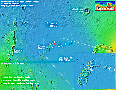
In early November 2025 I posted a cool image from Mars Reconnaissance Orbiter (MRO) that had the very provocative label “Characterize Possible Rotorcraft Landing Site”. While this was not the first such image taken by scientists using MRO to scout out potential landing zones for future Mars helicopter missions (see here and here), this particular image was one of several taken recently that were all within the candidate landing zone for SpaceX’s Starship spacecraft, focused specifically on the low Erebus mountain chain that sits within this part of Mars’ northern lowland plains.

In the January image download from MRO, I found another such image, taken on December 1, 2025. The map to the right shows that Starship candidate landing zone, with all the images taken for SpaceX indicated. The inset adds all the recent images taken for this “possible rotorcraft” mission, including the December image and the previous four (here, here, here, and here), with orange representing images already obtained and yellow those requested but pending.

I decided I needed to find out more, and tracked down the scientist who had requested the images, Eldar Dobrea of the Planetary Science Institute in Arizona. In response to my email, he explained:
» Read more

7 comments

Icy Mars

Overview map

Icy Mars

Today’s cool image once again illustrates the fact that most of Mars Mars is not a dry desert like the Sahara, as most news sources and the general public still believes, but a cold icy place similar to Antarctica, with plenty of near surface ice covering almost the whole planet, except for the dry equatorial regions (the one region we have sent almost all our landers and rovers).

The picture to the right, rotated, cropped, reduced, and sharpened to post here, was taken on November 26, 2025 by the high resolution camera on Mars Reconnaissance Orbiter (MRO). It shows one small section of the floor of an unnamed very old and eroded 82-mile-wide crater located in the northern mid-latitudes of Mars.

That location is indicated by the white dot on the overview map above. This part of the mid-latitudes is a region I dub “glacier country”, a 2,000-mile long strip where practically every image taken there shows very obvious glacial features.

Today’s image is no different. The 2-mile-wide crater in the upper left appears blobby, as if the impact had landed in mud. Its interior is filled with what the scientists believe is glacial debris. The surrounding landscape has a similar appearance, as if the ground was slushy and easily misshapen by seasonal temperature changes. To the southwest of the crater, within what appears to be a surrounding splash apron, there appears to be an eroded drainage channel, likely created by the flow of glacial ice downward.

So, when you read articles telling you Mars is dry and scientists are still hunting for water there, know that whomever wrote that article had no idea what he or she were talking about. The scientists studying Mars know that Mars has lots of water. Except for the tropics below 30 degrees latitude, there is near surface ice everywhere. Their questions revolve instead on figuring out how deep and extensive it is, and how it has shaped Mars’ overall geology.

1 comment

“Round Deposits” in Martian crater

Round deposits in a crater
Click for original image.

Today’s cool image could also be entered into my “What the heck?!” category of strange Martian geology. The picture to the right, cropped, reduced, and sharpened to post here, was taken on October 19, 2025 by the high resolution camera on Mars Reconnaissance Orbiter (MRO).

The science team labels this as “Round Deposits in Crater.” And yup, that’s what we have, round and flat small mesas inside an unnamed 3,500-foot-wide very shallow crater (no more than 10-20 feet deep) that also appears to be sitting higher than the surrounding landscape. Furthermore, several nearby craters are also raised, with one having its own oblong flat interior mesa. Moreover, the terrain around the crater appears stippled, as if it has been eroding or sublimating away.

The latitude, 37 degrees north, provides the first clue for explaining this weird landscape.
» Read more

0 comments

Many Martian mysteries in one spot

Many Martian mysteries in one spot
Click for original image.

Just because there are no new images coming back from Mars at this time because the Sun is in the way does not mean we can’t enjoy more cool Martian images. The picture to the right, cropped, reduced, and sharpened to post here, was taken on October 20, 2025 by the high resolution camera on Mars Reconnaissance Orbiter (MRO).

Labeled merely a “terrain sample,” this means it was taken not as part of any particular research project but to fill a gap in the camera’s schedule. The camera team needs to take regular photographs in order to maintain the camera’s proper temperature, and when there is a long gap they add a terrain sample image to the schedule. Usually they try to pick some target of interest.

In this case the target is this 2,500-foot-high cliff, in which we can see a whole range of Martian geological mysteries. First there are the slope streaks on the cliff, a feature unique to Mars but as yet unexplained. Resembling avalanches, these streaks leave no debris piles at their base, do not change the topography in any way, and can appear randomly throughout the year, fading with time. Though the streaks in this picture are dark, streaks can also be bright.

Both the parallel ridges at the base of the cliff, as well as the cliff itself, are remnants of other major geological events, at least based on present theories.
» Read more

5 comments

The three week communications blackout from Mars has begun

Last image before blackout from Curiosity
Click for original.

Last image before blackout from Perseverance
Click for original.

The two images to the right, both downloaded today (here and here) from the Mars rovers Curiosity (top) and Perseverance, illustrate quite clearly the beginning of the three-week-long communications blackout from Mars caused every two years when the orbits of Earth and Mars places the Sun in-between. As the Curiosity science team noted in a December 22, 2025 update:

This holiday season coincides with conjunction β€” every two years, because of their different orbits, Earth and Mars are obstructed from one another by the Sun; this one will last from Dec. 27 to Jan. 20. We do not like to send commands through the Sun in case they get scrambled, so we have been finishing up a few last scientific observations before preparing Curiosity for its quiet conjunction break.

Apparently engineers were able to squeeze data and images from Mars for a few extra days, but the incomplete nature of these two pictures — combined with the lack of any other new images today — tells us that the blackout has definitely begun. That they were able to get these additional images after conjunction began suggests the blackout might also end a bit earlier than expected.

Though there is always a concern that something could go wrong while communications are blocked, the risks are small. The science teams for all the Mars orbiters and rovers have dealt with this situation now almost a dozen times since operations became routine there more than a quarter century ago.

The only spacecraft at real risk this conjunction is Maven. Contact was lost from it in early December for unknown reasons, and all efforts to regain communications have so far failed. All engineers know from the little data they have gotten back is it appears to be tumbling. This three week blackout will make any chance of recovery extremely unlikely.

4 comments

The headwaters of an ancient Martian channel

glacial debris in canyon floor
Click for original image.

Cool image time! The picture to the right, rotated, cropped, reduced, and sharpened to post here, was taken on October 24, 2025 by the high resolution camera on Mars Reconnaissance Orbiter (MRO).

The science team labels this simply as “irregular terrain.” It is far more than that. We are looking at a three-mile-wide shallow canyon, with what appear to be eroding glacial features on the canyon floor.

The location is at 35 degrees north latitude, so finding glacial features here is entirely unsurprising, especially because this location is the southern edge of the 2,000-mile-long mid-latitude strip in Mar’ northern hemisphere I label glacier country, because almost every picture shows such glacial features.

In this case, the channel also suggests a much more complex geological history, that could involve flowing water though flowing glaciers are increasingly becoming an alternative explanation.
» Read more

0 comments
1 2 3 4 54