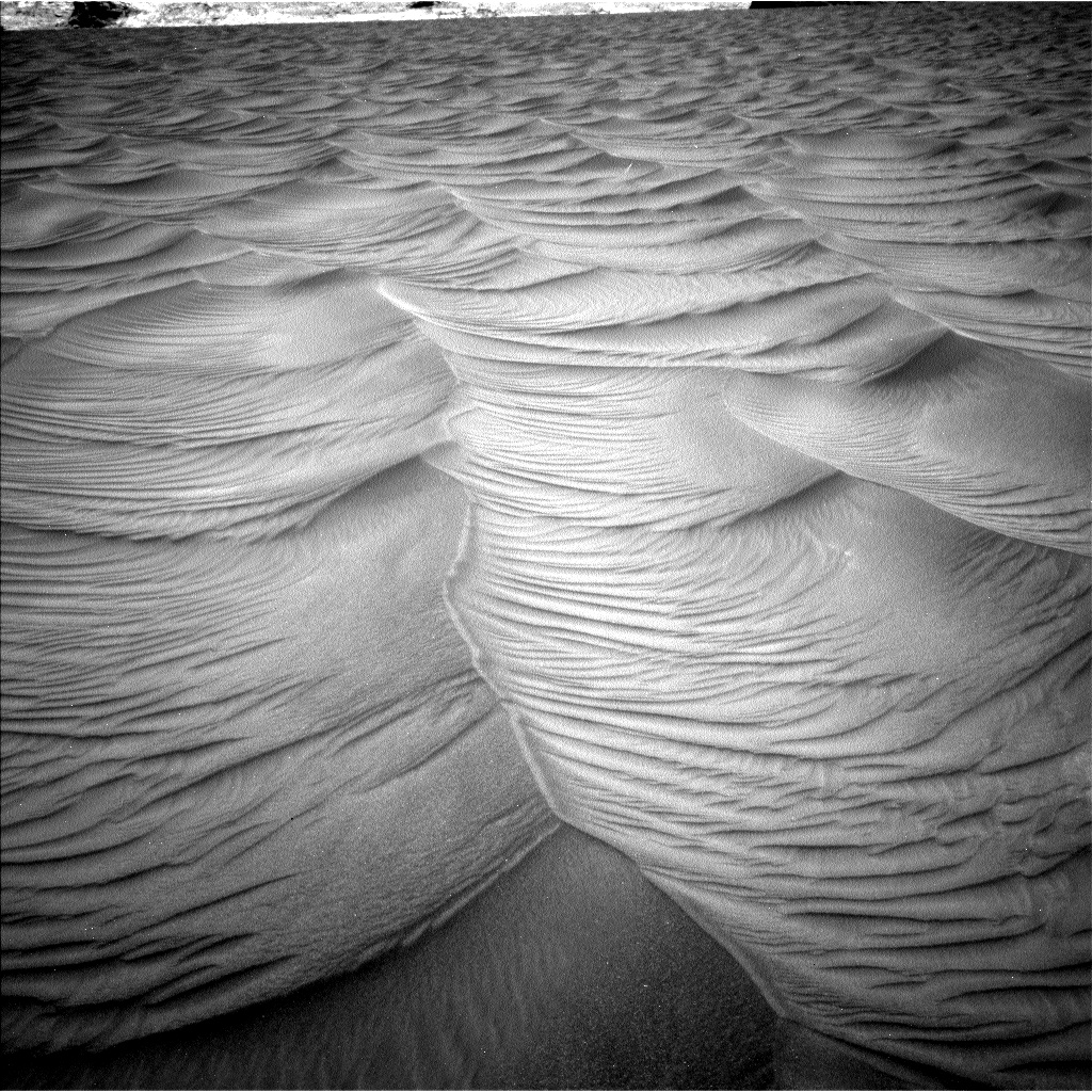
Cones on Mars!

Today’s cool image is actually a bunch, all found recently in the monthly image download from the high resolution camera on Mars Reconnaissance Orbiter (MRO).

All the photos I post below show pimple-like cones, all of which appear to be a type of small volcano. The cones are found in a wide range of locations, from the northern lowland plains to the cratered highlands to the mid-latitude transition zone between the two. They are also found at the bottom of deep canyons, in the floors of craters, and amidst mountains.

Let us begin.
» Read more

2 comments

Ancient and recent volcanoes on Mars

Volcanic vent on eastern flank of Olympus Mons
Click for full image.

Cool image time! The photo to the right, rotated, cropped, and reduced to post here, was taken by the high resolution camera on Mars Reconnaissance Orbiter (MRO) on October 25, 2020. It shows what it calls a “possible volcanic vent east of Olympus Mons”.

Is this active? If not, how old is it. Also, the elongated shape of the vent suggests the possibility of a lava tube, or at least some underground complexity to the release of its magma.

In order to get some clarity, I emailed Sarah Sutton of the Lunar and Planetary Laboratory of the University of Arizona, who requested this photograph. Her response:

The image is of a small shield volcano with an elongated vent at the summit. We don’t have complete stereo here yet, so we can’t tell exactly what the height is. This vent might have sourced tube-fed flows, but in this case, we can’t resolve such features in the image data. This and other small shield volcanoes in the vicinity are partially buried by plains-forming lava flows. The lava flows around the base overlap the flows that emanate radially from the summit vent. Therefore we infer that the shield is older than the surrounding lava flows.

The vent, which runs from the southwest to the northeast, sits on top of a sloping wide hill, which is that small shield volcano described by Sutton. The flat plains surrounding this hill are from later eruptions from other and possibly larger volcanoes. The wider overview map below might give us a clue as to the source.
» Read more

1 comment

Confirmed: Martian glacial features are ice

Lobate glacial flows on Mars
Click for full image.

Scientists using the radar instrument on Mars Reconnaissance Orbiter (MRO) have now confirmed that the Martian glacial features that most resemble the glaciers seen on Earth are made of substantial amounts of ice, and were possibly active and growing only a few million years ago.

“Our radar analysis shows that at least one of these features is about 500 meters thick and nearly 100 percent ice, with a debris covering at most ten meters thick,” said Berman, lead author of “Ice-rich landforms of the southern mid-latitudes of Mars: A case study in Nereidum Montes” published online in Icarus at https://doi.org/10.1016/j.icarus.2020.114170. PSI scientists Frank C. Chuang, Isaac B. Smith and David A. Crown are co-authors on the paper.

Global mapping of Viscous Flow Features (VFFs), a general grouping of ice-rich flow features in the southern hemisphere of Mars shows a dense concentration in Nereidum Montes, along the northern rim of Argyre basin. Located within a northwestern subregion of Nereidum Montes is a large number of well-preserved VFFs and ice-rich mantling deposits, the paper says, potentially the largest concentrations of any non-polar region in the southern hemisphere.

…Processed data from the Shallow Radar (SHARAD) instrument aboard NASA’s Mars Reconnaissance Orbiter spacecraft were used to search for basal reflections across VFFs within the region. For one in particular, these observations and analysis indicate that it is composed of nearly pure water ice. Model ages obtained from crater counts and their associated size-frequency distributions (SFDs) on both ice-rich mantling deposits and small lobate VFFs suggest that the deposits stabilized several to tens of millions of years ago in the Late Amazonian Epoch, and that small lobate VFFs likely formed due to the mobilization of mantling deposits.

This data here reinforces the impressions from many other places within the 30-60 degree latitude bands on Mars where many such features are found.

Mars might be a desert, but it is a desert like Antarctica, not the Sahara. Any settlement there must use the Earth’s south pole as its guide for construction and design.

6 comments

Strange crater in the basement of Mars

Strange crater in Hellas Basin
Click for full image.

Today’s cool image to the right, cropped and reduced to post here, is intriguing for a number of reasons. Taken on September 11, 2020 by the high resolution camera on Mars Reconnaissance Orbiter (MRO), it shows a partially buried crater found in the middle of Hellas Basin, the lowest point on Mars and what I like to call the red planet’s basement.

What makes this crater intriguing is the layered pile of material filling its interior. If I didn’t know any better, I would think some construction crew has used a bulldozer to push debris from the crater’s right half in order to smooth the ground in preparation for building a strip mall, office building, or housing development.

This of course is not what happened. Then what did create those layered piles in the crater’s left half?
» Read more

1 comment

Cryptic Terrain on Mars

Cryptic terrain near Mars' south polar ice cap
Click for full image.

Cool image time! The photo to the right, rotated and cropped to post here, was taken on September 27, 2020 by the high resolution camera on Mars Reconnaissance Orbiter (MRO). It shows what is likely a crater that is partly buried by ice and dust and sand near or on the edge of Mars’s south polar ice cap.

It also shows an example of what planetary scientists have dubbed “cryptic terrain,” found generally on the margins of that ice cap. In this case, the location is on a plateau adjacent to the ice cap dubbed Promethei Planum. Despite a lot of searching, I could not locate any research papers describing Promethei Planum, though data outlined in one Mars Express press release from 2008 suggested it was part of the polar ice cap more than two miles thick that is covered by a thin mantle of dry ice each winter.

The strange curlicue cliffs and plateaus seen here are thought to form as part of the arrival and then sublimation away of that seasonal dry ice mantle, but how that process exactly works to create these particular geological features remains I think a mystery. North is to the top. The general grade is also downhill away from the icecap to the north.

Moreover, the overview map below, with the location of this image indicated by the blue cross, illustrates more mysteries.
» Read more

1 comment

Landslides on the edge of Mars’ youngest lava field

Landslides on the edge of Mars' youngest lava field
Click for full image.

Cool image time! The photo to the right, cropped to post here, was taken by the high resolution camera on Mars Reconnaissance Orbiter (MRO) on September 28, 2020. It shows several indentations in a north-south cliff face, with debris apparently falling down into a flat plain to the east.

The scientific history of this picture is very interesting. The first photo of these landslides was taken in 2006 and was titled, “Landslides on Flat Topography in Elysium Planitia”. The second, taken a few months later in 2007 to produce a stereoscopic view, was labeled “Landslides Along Shoreline in Elysium Planitia.” This most recent 2020 image is merely labeled “Landslides in Elysium Planitia.”

Is the flat terrain to the west a seabed to an ancient ocean, as suggested by the title for the 2007 image, with these landslides erosion caused in the far past by water lapping up against these cliffs?
» Read more

2 comments

Terby Crater and its drainages into Mars’ basement

Channels in Terby Crater on Mars
Click for full image.

Cool image time! Over the past few years, in my endless rummaging through the archive of high resolution images from Mars Reconnaissance Orbiter (MRO) I have posted a lot of photos of meandering channels of all kinds, most of which evoke to Earth eyes canyons eroded by flowing water. (This September 2020 cool image is just one of the more recent examples.)

Today’s cool image is another example, but in this case it is only a very small part of a very large drainage basin that is more than a hundred miles across and extends at least that far southward into the basement of Mars, Hellas Basin, the place on Mars with the lowest elevation.

The photo to the right, rotated and reduced to post here, was taken on September 12, 2020 by the high resolution camera on MRO. I normally wouldn’t post the whole image, but to crop it would mean you wouldn’t get the sense of extensive nature of this drainage. Downhill is to the south. The channel apparently passes through three or four stages. First, its northernmost section is in a wide canyon, the floor of which resembles glacial debris (though with a latitude of 27 degrees south this is a bit too close to the equator for ice). More likely we are looking at wind-blown sand and dunes being pulled downhill in the floor of the canyon.

This first canyon is also actually a gap in the rim of a 13-mile-wide unnamed crater. See this MRO context camera image for a wider view.

Next, the drainage becomes a series of meandering small interweaving channels, resembling the channels often seen in beach mud as the tide goes out.

Finally, the channels head into a gap to fall over a sloping cliff into lower terrain.

Nor these stages entirely linked. The first glacial-like stage exiting the gap in the crater appears to drain to the southeast, while the second seems to emanate from what appears to be a very faint small crater now partly buried. Both head south toward the gap, but the path of the eastward drainage appears less obvious. Some of it flowed westward to join the meandering channels but some also appears to work its way south more to the east.

This one image shows a lot of channels, but it is only a very small slice of this whole drainage system. In fact, we are looking here at only one strip of the interior slope of the northern rim of 108-mile-wide Terby Crater.

The overview map below gives the larger context. Terby Crater sits on the northern border of Hellas Basin, which in itself extends another 1,500 miles to the south. From this point the drop in elevation into Hellas is almost four miles.
» Read more

0 comments

Ice-filled crater on Mars?

Crater in southern mid-latitudes
Click for full image.

Time for another of the many cool images from Mars that suggest the presence of buried glacial ice. The photo to the right, rotated, cropped, and reduced to post here, shows an unnamed crater in the cratered southern highlands of Mars at about 44 degrees south latitude. Taken on October 2, 2020 by the high resolution camera on Mars Reconnaissance Orbiter (MRO), the crater sits at the very southernmost point of the Tharsis Bulge where the Red Planet’s four more distinctive giant volcanoes are located.

The crater is also in the middle of the 30 to 60 degree mid-latitude bands where scientists have detected many features that suggest glaciers, including a large number of craters that appear to have ice filling their interior.

Does the material in this crater’s floor suggest eroding and sublimating ice to you? It does to me. The second image below zooms in at full resolution at the north-south trench and the strange patterned terrain to its east.
» Read more

0 comments

Aram Chaos: Illustrating the puzzle of Mars

Aram Chaos
Click for full image.

The geological history of Mars is incredibly complex, and we really don’t know much about it. What we do know right now is based on a limited number of tiny fragments of a much larger story, with those fragments allowing scientists to only make educated guesses on how they fit together.

Many of those guesses will certainly turn out right. Just as many will turn out wrong. At this moment in our exploration of the Red Planet we can only grasp at straws while always keeping an open mind, as later data is surely going to change any conclusions we presently have.

The photo to the right is a good illustration of this struggle. Rotated, cropped, and reduced to post here, it was taken on September 27, 2020 by the high resolution camera on Mars Reconnaissance Orbiter (MRO), and shows what at first glance looks like a stream of white frost or ice descending down a canyon to the south.

That first impression however is entirely wrong. When I asked Chris Okubo of the U.S. Geological Survey, who requested this image from MRO, what it was, he explained,

The white material is not frost. Instead, these are sedimentary rocks comprised primarily of sulfates. The texture to me suggests these are lithified dunes.

Lithified merely means that the dunes have hardened into rock. Sulfates are a salt formed from sulfuric acid, and are on Mars often linked to some complex mineralogy. If you stood there the colors would be white and red, quite beautiful. As Okubo explained,

The sulfates are white to tan in color, but there would also be a lot of red/brown Mars dust on top of it. It would be similar to walking around some of the playas in the desert southwest.

Though these white sulfate deposits have their root in sulfuric acid, Okubo added that they “are in the form of minerals similar to gypsum and so they would be safe to touch.”

What is going on here? As is usually the case, we need to first take a wider view to get some context.
» Read more

0 comments

Sagging cliffs on Mars

Sagging escarpment on Mars
Click for full image.

Cool image time! On Mars things change, but not like on Earth because the atmosphere is not as thick and there is no flowing water. The photo to the right, rotated, cropped, reduced, and annotated to post here, gives a good example of that slow change. The image was taken on August 29, 2020 by the high resolution camera on Mars Reconnaissance Orbiter (MRO), and shows the high escarpment that in this one place separates the planet’s southern cratered highlands from the transition zone down to northern lowland plains.

In this spot that escarpment, approximately 4,000 feet high, shows signs of avalanches and sagging. In the upper steep section, I point to what looks like a dust avalanche that wiped the slope clear of rough terrain as it rolled downhill. At the bottom of the cliff a large section has separated away. Since this cliff is located at 28 degrees north latitude and is in the midst of the chaos terrain regions I like to dub glacier country, it is very possible that this large section is actually buried glacial ice that in shifting down slope cracked, separating the lower section from the upper.

This particular location is east of an area dubbed Nilosyrtis Mensae (where there is a lot of evidence of glaciers and frozen ice), and about 650 miles north of Jezero Crater, where the rover Perseverance will land on February 18, 2021.

0 comments

A spray of Martian meteorites

A spray of small secondary impacts
Click for full image.

Cool image time! The photo to the right, cropped and reduced to post here, was taken on October 26, 2020 by the high resolution camera on Mars Reconnaissance Orbiter (MRO). It is what the camera team calls a “terrain sample,” meaning it was not specifically requested by a researcher but was instead chosen by the camera team because they need to regularly take images to maintain the camera’s temperature. When they do this, they try to pick a location that hasn’t been photographed in high resolution previously, and that might have some interesting features. Sometimes the photo is boring. Sometimes they hit pay dirt.

In this case, the photo captured an small impact crater, about 1,300 feet across, surrounded by a spray of secondary impacts. The color portion of the image shows what I suspect are dust devil tracks cutting across a surface that, because of its blue tint, is either rough or has frost or ice within it. At 48 degrees north latitude, the possibility of the latter is high, especially because this location is northwest of the Erebus mountains, where SpaceX has its prime Starship candidate landing zone and where scientists suspect ice is readily available very close to the surface. The overview map below shows this context.
» Read more

2 comments

A place on Mars where lakes, snowfall, and rivers once existed

Inverted channels near Juventae Chasma
Click for full image.

Cool image time! The photo to the right, cropped and enhanced to post here, attracted my immediate interest when I was going through the November image dump from Mars Reconnaissance Orbiter (MRO) because of its meandering sharp ridges, estimated to be about sixty feet high on average. While I have previously posted MRO images of inverted channels such as these, their particular sharpness, plus their large number in this localized single image, aroused my curiosity. What is their history? Does this illustrate an particularly interesting place on Mars?

The picture itself was taken was on September 29, 2020 by MRO’s high resolution camera. The blue areas in the color strip probably indicate coarser-grained surface. This makes sense, as these ridges are believed to have been initially carved as channels by flowing water or ice, which compressed their riverbed and thus made it resistant to erosion. Over time, the surrounding terrain eroded away, leaving that channel behind now as a upstanding ridge. The surrounding eroded terrain should thus be expected to be rougher.

Where did the water for these rivers come from, however? As always, the overview maps below give the context, and a possible explanation.
» Read more

2 comments

Eroded and possibly wet Lohse Crater

Gully flow near central peak of Lohse Crater on Mars
Click for full image.

Cool image time! Today we take a look at one particular 100-mile-wide crater, Lohse Crater, located in the southern cratered highlands on Mars. The photo to the right, cropped and reduced to post here, focuses in on one of the many eroding gullies found in the mountainous region surrounding the crater’s central peak. Taken on August 20, 2020 by the high resolution camera on Mars Reconnaissance Orbiter (MRO), the full image is centered on that central peak, just off the south edge of this cropped section. This new image is part of a long monitoring campaign, begun in 2007, of this central peak region. For more than six Martian years, scientists have been tracking the numerous gullies found throughout the central peak region to see if there have been any changes.

I focused on this specific gully because I think it illustrates well why planetary scientists are monitoring these gullies. Whatever flowed down from the cliff on the left hit the material on the right hard enough and fast enough to imprint a curve into the material on the crater floor. Moreover, it does not appear to have simply been a landslide, for several reasons. First, the cliff does not appear cut back at the flow’s head, as you would expect if a section had broken off. Second, the material in the flow does not look like debris from an avalanche. In fact, there does not appear to be very much debris in the gully at all.

Third, and most important, the flow appears to originate at the cliff base, kind of what you’d expect if there was seepage coming out of a layer in that cliff face. Kind of what you’d expect on Earth, at a spring!

Was that flow water? This is the big question. Lohse Crater is significant in that it was one of the first locations on Mars [pdf] spotted by Mars Global Surveyor in the late 1990s where gullies were found suggesting some form of regular erosion possibly caused by flowing water. As this 2005 paper then concluded,
» Read more

3 comments

Giant wind eddies in the sands of Mars

Wind eddies on Mars
Click for full image.

Cool image time! The image to the right, cropped and reduced to post here, was photographed by the high resolution camera on Mars Reconnaissance Orbiter (MRO) on August 5, 2020. It shows a cluster of the crescent-shaped gullies, apparently carved from desert sand by the prevailing winds.

Those prevailing winds here are from the southwest to the northeast. As the wind blows the sand to the east, it hits a more solid object, such as a mountain buried in the sand, which forces the wind and the blown sand to go around, much as water passes a boulder in river rapids. That solid object also causes an eddy to form at its face, the wind forced downward and then around and up, carving out the gullies by lifting the sand at the base of that solid object. The result are these crescent gullies, dubbed blow-outs.

The overview map helps explain why there is so much sand here, enough apparently to bury whole mountains.
» Read more

3 comments

Glacial eddies on Mars?

Glacial eddies on Mars?
Click for full image.

Cool image time! The photo to the right, cropped and reduced to post here, was taken on August 15, 2020 by the high resolution camera on Mars Reconnaissance Orbiter (MRO). It shows a truly strange bunch of blocks beside a clean flow neatly organized in almost straight parallel lines.

What is going on? This location is at 38 degrees south latitude, a latitude where scientists have found a lot of features that resemble water ice glaciers, generally protected from sublimating away by a thin layer of dust and debris.

A first guess is that the smooth glacial flow at the lower right is disturbing the glacial material next to it, causing it to rip apart and break up. At the same time, the hollowed look of these glacial blocks suggests that the ice below that protective debris layer is also slowly sublimating away, causing the surface to sink.

The wider shot below helps confirm this impression.
» Read more

0 comments

Curiosity data suggests the occurrence of mega floods in Gale Crater

The uncertainty of science: Using Curiosity data a team of scientists are now suggesting that some of the features the rover has seen were created during mega flood within Gale Crater, and this data also requires a rethinking of the present theories of the crater’s geological history.

This case includes the occurrence of giant wave-shaped features in sedimentary layers of Gale crater, often called “megaripples” or antidunes that are about 30-feet high and spaced about 450 feet apart, according to lead author Ezat Heydari, a professor of physics at Jackson State University.

The antidunes are indicative of flowing megafloods at the bottom of Mars’ Gale Crater about 4 billion years ago, which are identical to the features formed by melting ice on Earth about 2 million years ago, Heydari said.

The most likely cause of the Mars flooding was the melting of ice from heat generated by a large impact, which released carbon dioxide and methane from the planet’s frozen reservoirs. The water vapor and release of gases combined to produce a short period of warm and wet conditions on the red planet.

The press release above focuses on the catastrophic floods, but the research paper itself is really much more focused on the need to rethink present hypotheses for explaining the observed geology in Gale Crater. This report notes that they are finding patches of material that could not have been laid down as seen, based on those past theories, and proposes the catastrophic flood event as a possible solution.

In reading the paper however it is evident that even this new hypothesis is based on a limited amount of data, and thus can have holes punched in it as well. This is not to say that the paper is invalid, only that it must be taken with some skepticism. The data being obtained at Gale Crater simply incomplete. Curiosity is following only one path, and has not even left the foothills of Mount Sharp. In order to gain a wider and fuller understanding geologists need to study the entire crater floor, as well as the geology on the mountain.

1 comment

Frost on a Martian hillside

Frost on Martian hillside
Click for full image.

Cool image time! The image to the right, cropped to post here, was taken on August 27, 2020 by the high resolution camera on Mars Reconnaissance Orbiter (MRO). It shows a flat-topped mesa in an enclosed canyon dubbed Sisyphi Cavi in the high southern latitudes of Mars during the spring.

Notice the white spots in the gullies on the southern-facing slopes? From what I can gather from a bit of research, these indicate the presence of carbon dioxide frost. It was spring at this location when the photo was taken. At that time, the thin seasonal mantle of dry ice that covers Mars’ the polar regions south to 60 degrees latitude in the winter is sublimating away. This would explain why the frost is only present in the south-facing slopes. Since this is in the southern hemisphere, the south-facing slopes get much less sunlight, and would sublimate away later.

The photo was taken as part of a monitoring program to study this sublimation process. According to this abstract:

Superposition of channel features over and/or through the defrosting CO2 snowpack shows that the channels are active at the present day and probably have fluid flows every spring during the annual defrosting. In itself, this is a significant observation as active fluid flows of any nature have not yet been proven on Mars. However, the ambient temperature at the time of gully activity appears to require a role for CO2 in the formation of the channels, rather than water.

In other words, the coming and going of this dry ice frost each Martian year, in conjunction with the underground water ice also found here, appears to be causing erosion that then creates of the gullies themselves. More details from the abstract in this paper:
» Read more

0 comments

ESA completes new parachute test for its 2022 Mars rover

On November 9, 2020 the European Space Agency finally conducted the high altitude parachute test of the landing system for its 2022 Mars rover Rosalind Franklin that had been planned for March but had been delayed due to the Wuhan flu panic.

The timeline of the latest test, including extraction and deceleration, went exactly to plan. However, four tears in the canopy of the first main parachute and one in the second main parachute were found after recovery. The damage seemed to happen at the onset of the inflation, with the descent otherwise occurring nominally.

The team are now analysing the test data to determine further improvements for the next tests. Planning is underway for future tests in the first half of next year, to ‘qualify’ the complete parachute system ready for launch in September 2022.

Overall they consider the test a success, though the damage issues must be solved before the ’22 launch. Based on this test it also appears that the ESA made a very wise choice delaying the mission from launch this year, as its parachute system was clearly not ready.

0 comments

Buried mountain on Mars

Isolated buried mountain on Mars
Click for full image.

Cool image time! The photo to the right, rotated, cropped, and reduced to post here, was taken on August 8, 2020 by the high resolution camera on Mars Reconnaissance Orbiter (MRO). Labeled merely as a “terrain sample,” it is an example of an image taken more for engineering than scientific reasons. No research scientist specifically requested it. Instead, the scientists operating the camera took it because they need to use MRO regularly to maintain the camera’s proper temperature. To do this they periodically take almost random images, but never without trying to pick a location that might have some scientific value.

In this case we get what appears to be an isolated sloping hill. Located at about 15 degrees north latitude, this is not a place where one would expect visible evidence of water, though the gullies on the slopes are intriguing. They almost look like the kind of hillside erosion you see in places where rain falls on desert mountainsides.

Rain can’t be the cause, but nonetheless monitoring these gullies for changes over time would be worthwhile science research. Since it appears no one is presently focused on doing it, anyone interested out there?

This mountain is actually far more isolated than this high resolution image suggests.
» Read more

8 comments

A majestic terraced butte on Mars

Majestic butte on Mars
Click for full image.

Cool image time! The photo to the right, rotated, cropped, and reduced to post here, was taken on September 8, 2020 by the high resolution camera on Mars Reconnaissance Orbiter (MRO). It shows an outstanding terraced butte that would rival any of the similar buttes scattered throughout the Grand Canyon, and is reminiscent especially of Wotans Throne.

What makes this butte intriguing are its terraces, the obvious result of the repeated deposition of new layers across the surface over time, and now exposed by erosion. What caused them?

As always, location provides the clues. First, this butte is found at about 15 degrees north latitude in the vast Arabia Terra transition region between the Martian northern lowland plains and the southern cratered highlands. At that latitude, we are not looking at any recent glacial features. While there might have been ice here once, it hasn’t likely been present, either on the surface or underground, for a very long time.

This conclusion becomes important once we look at the wider photo below, taken by the high resolution camera on the European orbiter Mars Express. This image gives us the immediate context.
» Read more

0 comments
1 66 67 68 69 70 127