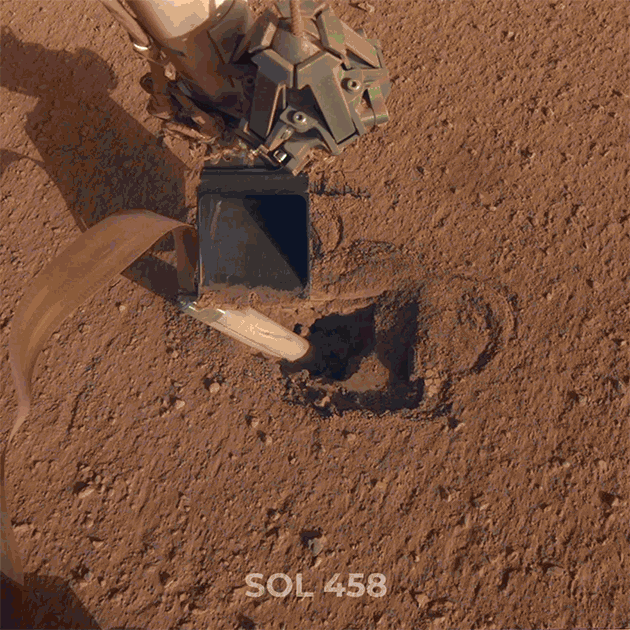
The blobby wettish flows of Mars

flow-like feature in Utopia Planitia
Click for full image.

Cool image time! Rather than talk about shut downs, lying politicians, and our tragically fear-filled society, let’s go exploring on Mars. The image to the right, rotated, cropped, and reduced to post here, was taken by the high resolution camera on Mars Reconnaissance Orbiter (MRO) on February 8, 2020. Dubbed a “Flow-Like Feature within the Adamas Labyrinthus”, it shows what appears to be a very distorted and eroded pedestal crater surrounded by strange triangular-shaped flow features.

It also shows, as does much other research, that the northern mid-latitudes of Mars have a lot of frozen water, much of it buried very close to the surface.

Assuming this is a pedestal crater (which it might not be), this feature has to be very old. Pedestal craters require age, as to stand out above the surrounding terrain a lot of time is needed to erode that terrain away. This age is confirmed by the bunch of newer craters on top.

At the same time, the partially filled small crater near its bottom, as well as the soft eroded depressions on top, suggest that much of this surface has been reshaped by more recent flows, changing its shape over time.

The surrounding triangular flows probably occurred at the original impact, and suggest that there is ice near the surface, making the material here act almost like wet mud when heated. Since this location is right in the middle of the mid-latitude bands where scientists have found lots of evidence of buried glaciers and ice near the surface, this supposition seems reasonable.

The overall location provides some further context.
» Read more

0 comments

The salty liquid water on Mars

Map of seasonal salty liquid water on Mars
Click for full unannotated image.

The map above, reduced and annotated by me, comes from a new science paper that has attempted to model where on Mars we might find liquid very salty water, based on the planet’s known temperature and make-up. From the press release:

The team of researchers used laboratory measurements of Mars-relevant salts along with Martian climate information from both planetary models and spacecraft measurements. They developed a model to predict where, when, and for how long brines are stable on the surface and shallow subsurface of Mars. They found that brine formation from some salts can lead to liquid water over 40% of the Martian surface but only seasonally, during 2% of the Martian year.

“In our work, we show that the highest temperature a stable brine will experience on Mars is -48°C (-55° F). This is well below the lowest temperature we know life can tolerate,” says Dr. Rivera-Valentín. “For many years we have worried about contaminating Mars with terrestrial life as we have sent spacecraft to explore its surface. These new results reduce some of the risk of exploring Mars,” noted Dr. Alejandro Soto at the Southwest Research Institute and co-author of the study. [emphasis mine]

I have added a red rectangle to the map, showing the candidate landing zone for SpaceX’s Starship. This paper illustrates again that this choice is a good one. We know from other research that there is a lot of ice very close to the surface here. This research indicates that for a little less than one percent of each year, some of that ice will turn to liquid brine.

Whether it will be easier to process the ice or the brine into drinkable water remains unknown. This location however will give future colonists that option.

That this model also suggests that there is little risk of contaminating Mars accidently with terrestrial life is really not a surprise. All the research of Mars for decades has found that it is inhospitable to terrestrial life. This data however is further confirmation, and tells us once again that worrying about contaminating the planet is a irrelevancy. For scientific reasons some precautions should be taken, but to spend a lot of time and money sterilizing the spacecraft we send there will be a fool’s errand. For humans to settle Mars will require a very very high level of engineering and adaptation, something we humans are very naturally good at, but something that shouldn’t be burdened with unnecessary tasks or restrictions.

3 comments

A relaxed crater on Mars

A relaxed crater on Mars
Click for full image.

Cool image time! The photo to the right, rotated, cropped, and reduced to post here, shows what the science team for the high resolution camera on Mars Reconnaissance Orbiter (MRO) call a “Relaxed Crater.” This particular image was taken in July 2014. A more recent photo was taken in March 2020 to create a stereo pair, but because this older image shows more of the crater I decided to highlight it.

The crater is considered relaxed because it is very shallow and appears as if, after impact, some process caused the interior to in-fill with material even as the rim became less pronounced and degraded (as explained in this paper [pdf]). The process could have involved either molten magma or melted ice. As this crater is located in the northern highlands to the southwest of Erebus Mountains, in a region that research has consistently suggested has a great deal of ice just below the surface, the latter seems likely. This assumption is further reinforced in that the crater is also located in the mid-latitudes where scientists have found a lot of craters they think are filled with buried glaciers. This certainly seems the case here.
» Read more

0 comments

UAE’s Mars probe arrives in Japan for launch in July

The new colonial movement: The United Arab Emirates’ (UAE) Mars orbiter, dubbed Hope, has arrived at its launch site in Japan in preparation for its July launch on a Mitsubishi H-2A rocket.

Previously I had thought the probe had been built in the UAE with help from engineers from India, but that was not the case. Instead, the probe was mostly built by Americans, in America.

Carrying three science instruments, the Hope mission will measure conditions in the Martian atmosphere from a unique semi-synchronous orbit high above the Red Planet. The mission is the first from the Arab world to travel to another planet.

About the size of Mini Cooper, the spacecraft was assembled at LASP’s facilities in Colorado [Laboratory for Atmospheric and Space Physics], with the help of Emirati engineers and scientists. The probe was delivered to Dubai in February for additional testing, and then was supposed to be transported to Japan in early May.

But the coronavirus pandemic forced officials to shuffle the schedule, and mission managers decided to send the probe to Japan early. [emphasis mine]

In other words, this probe might be financed by the UAE, and it might have UAE engineers and scientists involved, but essentially the UAE paid LASP to build it for them.

I am not criticizing the UAE for this effort, but to call it an Arab mission is somewhat dishonest. This is a joint American-UAE probe. If it results in producing qualified engineers in the UAE capability of building their own future planetary probe, fine. They are not doing it now, however.

0 comments

The eroding edge of Mars’ largest volcanic ash field

Eroding yardangs at the edge of Mars' largest volcanic ash field
Click for full image.

Cool image time! In the regions between the biggest volcanoes on Mars is the Medusae Fossae Formation, a immense deposit of volcanic ash that extends across as much surface area as the nation of India. As planetary scientist Kevin Lewis of Johns Hopkins University explained to me previously,

In general, much of the [formation] seems to be in net erosion now, retaining very few craters on the surface. …One hypothesis is that this long term erosion, since it’s so enormous, is the primary source of the dust we see covering the much of the planet’s surface.

The image above, cropped and reduced to post here, was taken by the high resolution camera on Mars Reconnaissance Orbiter (MRO) on January 25, 2020. It shows one very small area at the very edge of the Medusae ash deposit, in a region where that deposit is clearly being eroding away by the prevailing southeast-to-northwest winds. The mesas of this ash that remain are called yardangs, their ash more tightly pressed together so that it resists erosion a bit longer than the surrounding material.

In the context map below the location of these yardangs is indicated by the white cross, right on the edge of the Medusae ash field.
» Read more

0 comments

The edge of Mars’ north polar ice cap

The scarp face of the Martian north polar ice cap
Click for full image.

Cool image time! The photo to the right, cropped and reduced to post here, was taken on December 29, 2019 by the high resolution camera of Mars Reconnaissance Orbiter (MRO) and shows the many-layered scarp face of the Martian north polar ice cap. I have also rotated the image so that north is at the top. The overall height of this scarp is quite high, more than 3,500 feet.

There are a number of very cool features in this image. For example, note what at first look like puffs of clouds just below the contact between the bright and dark layers. I count almost two dozen, with the largest near the center. They are not cloud puffs, however, but areas scoured by past avalanches. According to Patricio Becerra at the University of Bern in Switzerland,

An image from a few years ago shows evidence for the same patches, so they likely happened a while back. When the avalanches or “block falls” occur, they scour the Basal Unit [the dark layer] and break up the exposed surface, causing a brighter/cloudier appearance of the ground than the undisturbed parts.

Avalanches on the scarps of the North Pole icecap occur in great numbers at the beginning of every Martian summer. As sunlight hits the scarp, it causes the carbon dioxide frost layer that settled on the cap during the winter to sublimate away as vapor, and like the freeze-melt cycle on Earth, this sublimation disturbs any unstable ice boulders on the scarp face.

During the early Martian summer, images from MRO routinely capture many such avalanches. Scientists think there could be hundreds to thousands every summer. In many ways, this is similar to the large pieces of ice that routinely calf off the foot of glaciers here on Earth, and that tourists take cruise ships to see in the inside passage of Alaska.

For context, the overview map below indicates with a gold cross where on the icecap’s edge this image is located. The red and pink areas indicate the vast dune fields that surround the icecap.
» Read more

0 comments

Scientists better constrain time frame of Mars’ active dynamo

Using data from the MAVEN orbiter, scientists have now constrained the time frame when Mars’ dynamo was active and producing a global magnetic field, between 3.7 and 4.5 billion years ago.

Magnetism in certain rocks on Mars’ surface indicate that the Martian dynamo was active between 4.3 and 4.2 billion years ago, but the absence of magnetism over three large basins – Hellas, Argyre, and Isidis – that formed 3.9 billion years ago has led most scientists to believe the dynamo was inactive by that time.

Mittelholz’s team analyzed new data from NASA’s Mars Atmosphere and Volatile Evolution (MAVEN) orbiter and found clear evidence of a magnetic field coming from the Lucus Planum lava flow that formed about 3.7 billion years ago – much later than at other areas studied.

There is of course a lot of uncertainty here.

0 comments

Curiosity and other Mars orbiters threatened by budget cuts

The proposed budget for NASA in the Trump administrations 2021 budget request to Congress includes significant budget cuts to both Curiosity and several Mars orbiters needed to act as relay communications satellites.

The White House’s 2021 federal budget request allocates just $40 million to the mission, a decrease of 20% from the rover’s current funding. And that current funding is 13% less than Curiosity got in the previous year, said Curiosity project scientist Ashwin Vasavada, of NASA’s Jet Propulsion Laboratory (JPL) in Pasadena, California.

If the 2021 request is passed by Congress as-is, Curiosity’s operations would have to be scaled back considerably. Running the mission with just $40 million in 2021 would leave unused about 40% of the science team’s capability and 40% of the rover’s power output, which comes from a radioisotope thermoelectric generator (RTG), Vasavada said.

In addition, the proposed budget will require a 50% reduction in imaging by Mars Reconnaissance Orbiter, the end to the Mars Odyssey orbiter, and a significant but unspecified reduction in the use of the MAVEN orbiter.

I reported these facts back in March but there is no harm in noting them again.

The question is not whether there should be cuts at NASA. Considering the overall federal debt and annual budget deficit, NASA’s budget should be cut. The question is what to cut. The planetary program, probably NASA’s most successful program, is certainly not the program to cut. Instead, the Trump administration should be cutting the waste and badly run programs, like SLS, that spend billions and accomplish nothing.

If Congress and Trump did this, they could cut NASA’s total budget and still have plenty left over for the commercial manned program — including going to the Moon — and also increase the budget to the planetary program. I’ve been saying this since 2011, and nothing has happened in the past decade to change that conclusion.

3 comments

Perseverance’s helicopter named Ingenuity

After sifting through the 28,000 name suggestions submitted by K through 12 American students for naming the Mars rover Perseverance, NASA has chosen to use a suggestion from an Alabama high school student to name the rover’s prototype test helicopter Ingenuity.

As a technology demonstration, Ingenuity is a high-risk, high-reward experiment. The helicopter will ride to Mars attached to the belly of the Perseverance rover, which is preparing for launch in July or August. For several months following the rover’s landing, Ingenuity will remain encapsulated in a protective cover to shield it from debris during entry, descent and landing. When the timing in the rover mission is right, Ingenuity will be deployed to stand and operate on its own on the surface of the Red Planet. If the 4-pound (2-kilogram), solar-powered craft – a combination of specially designed components and off-the-shelf parts – survives the cold Martian nights during its pre-flight checkout, the team will proceed with testing.

If successful during its 30-Martian-day (31-Earth-day) experimental flight test window, the small craft will prove that powered flight can be achieved at Mars, enabling future Mars missions to better utilize second-generation helicopters to add an aerial dimension to their explorations.

The student, Vaneeza Rupani, had proposed the name for the rover. She instead is honored for the helicopter.

1 comment

A Martian lava flood plain

A Martian lava flood plain?
Click for full image.

Cool image time! The photo to the right, cropped to post here, was taken by the high resolution camera on Mars Reconnaissance Orbiter (MRO) on March 2, 2020, and shows some inexplicable shallow pits and depressions in the middle of a relatively flat and featureless plain.

Make sure you click on the image to see the full photo. Though the plain looks remarkably smooth, a handful of dark splotches are scattered about, almost all of which occur on top of small craters.

What causes these depressions? The MRO team calls this “Landforms near Cerberus Tholi.” Cereberus Tholi is a a collection of several indistinct and relatively small humps that scientists think might be shield volcanoes.

More clues come from the overall context.
» Read more

1 comment

China names its 2020 Mars mission

China’s official state-run press today announced that their 2020 Mars mission will be called Tianwen-1, noting that this name will be applied to all further planetary missions.

The link goes to that government state-run press, which provides no further information on Tianwen-1, such as where on Mars its lander/rover will land, its exact launch date, the instruments on board, etc. So far very very few details have been released.

What this propaganda press announcement does do is spout a lot of blather about how wonderful China is, and how we should all be thankful the communists have been in charge there. Here are some snippets to lighten your day:

  • …signifying the Chinese nation’s perseverance in pursuing truth and science
  • …a window for the Chinese public and the world to get a better understanding of China’s aerospace progress.
  • Chinese space engineers and scientists have overcome various difficulties and achieved aerospace development through self-reliance and independent innovation.
  • …promoting human welfare on the basis of equality, mutual benefit, peaceful utilization and inclusive development.

While China’s achievements in space are real (though much of the engineering was stolen or borrowed from others), these propaganda claims are junk and lies. Chinese space engineers are “self-reliant” and have “independence”? Don’t make me laugh. Everything done in their space program is dictated and controlled from the top, by the Chinese government and the Communist Party. No one is free to do anything, without their permission.

As for China’s pursuit of “truth and science”, their behavior during the Wuhan flu epidemic, originating from their country and very possibly caused deliberately or incompetently by them, makes this claim ludicrous on its face. They have lied, arrested scientists, blocked research, and distorted the scope and magnitude of the epidemic from day one.

Even a tiny bit of truth from them, from the beginning, might have prevented the panic that has overtaken the world which in turn appears to have triggered the next great economic depression, what I like to now call the Great Wuhan Depression.

1 comment

Stucco on Mars

Stucco on Mars
Click for full image.

As a break from Wuhan flu madness I give you another cool image, cropped and reduced to post here, taken by the high resolution camera on Mars Reconnaissance Orbiter (MRO). I call this stucco on Mars because that is exactly what it looks like. It is as someone laid down a layer of damp concrete and then ran over it roughly with a trowel to raise the knobs scattered across the surface.

The uncaptioned MRO image calls this “Aligned Mounds with Broad Summit Pits”. Those aligned mounds run across the top of the image. I suspect they are pedestal craters, left over because the impact had packed and hardened the crater so that it resisted erosion as the surrounding terrain was worn away.

The two insets, posted below at full resolutoin, focus on one of those pedestal craters as well as the distinct mesa at the bottom of the photo.
» Read more

0 comments

Rock droplets hitting a Martian plain

Depressions in Amazonis Planitia
Click for full image.

Cool image time! The photo the right, rotated, cropped, and reduced to post here, is not only cool, it contains a punchline. It was taken by the high resolution camera on Mars Reconnaissance Orbiter (MRO) on February 11, 2020 and shows one small area between two regions in the northern lowlands of Mars, dubbed Amazonia Planitia (to the south) and Arcadia Planitia (to the north) respectively.

This region is thought to have a lot of water ice just below the surface., so much in fact that Donna Viola of the University of Arizona has said, “I think you could dig anywhere to get your water ice.”

I think this image illustrates this fact nicely. Assuming the numerous depressions seen here were caused by impacts, either primary or secondary, it appears that when they hit the ground the heat of that impact was able to immediately melt a wide circular area. My guess is that an underwater ice table immediately turned to gas so that the dusty material mantling the surface then sagged, creating these wider circular depressions.

Of course, this is merely an off-the-cuff theory, and not to be taken too seriously. Other processes having nothing to do with impacts could explain what we see. For example, vents at the center of these craters might have allowed the underground ice to sublimate away, thus allowing the surface to sag.

So what’s the punchline?
» Read more

1 comment

Strange terrain in the Martian lowlands

Strange terrain in northern lowlands
Click for full image.

Cool image time! The science team for the high resolution camera on Mars Reconnaissance Orbiter (MRO) yesterday released a new captioned image, entitled “Disrupted Sediments in Acidalia Planitia”, noting that the photo

…shows a pitted, blocky surface, but also more unusually, it has contorted, irregular features.

Although there are impact craters in this area, some of the features … are too irregular to be relic impact craters or river channels. One possibility is that sedimentary layers have been warped from below to create these patterns. The freezing and thawing of subsurface ice is a mechanism that could have caused this.

The image to the right, rotated, cropped, and reduced to post here, shows the lower quarter of the full image. While in some areas it does appear as if changes below the surface caused the surface to warp and collapse, as suggested by the caption, in other places it looks more like the top layers themselves sublimated away without disturbing what was below them.

Note for example the pits near the bottom of the photograph. They clearly show sedimentary layers on their cliff walls, including the tiny circular mesa in the middle of the rightmost pit.

If these pits were collapsing from below, their cliffs would be more disturbed, because it would have been those lower layers that sublimated first. Instead, it appears that the top layer disappeared first, followed by each lower layer, one by one.

This region of strange terrain is located in the middle of the northern lowland plains. The overview map below gives some context, with the small white box showing this photo’s location.
» Read more

0 comments

Rover update: Curiosity heads downhill

Curiosity's last look across the Greenheugh Pedimont
Click for higher resolution.

[For the overall context of Curiosity’s travels, see my March 2016 post, Pinpointing Curiosity’s location in Gale Crater. For the updates in 2018 go here. For a full list of updates before February 8, 2018, go here.]

After finally reaching the top of the Greenheugh Pedimont (see both the March 4 and March 8, 2020 rover updates) and spending more than a month there, drilling one hole, getting samples, and taking a lot of photos, the Curiosity science team in the past week has finally sent the rover retreating back downhill, following the same route it used to climb uphill.

The panorama above was taken on April 10, 2020, and shows the last view looking south across that pedimont towards Mount Sharp, before that descent. As you can see, trying to traverse that terrain would have been very difficult, and probably very damaging to Curiosity’s wheels.
» Read more

0 comments

Baby Martian volcanoes

Cratered cone near Noctis Fossae
Click for full image.

Cool image time! I came across this strange feature shown on the right in my normal rummaging through the archive of the high resolution camera on Mars Reconnaissance Orbiter (MRO). The photo, rotated, cropped, and reduced to post here, focuses on what they label a “cratered cone.”

The immediate thought is that this is a volcano cone, and the craters at its peak are not impact craters but calderas. In science however such a knee-jerk conclusion is always dangerous. For example, this might instead be a pedestal crater, where the surrounding terrain was worn away over eons, leaving the crater sitting high and dry.

It is therefore important to look deeper to determine what origin of this feature might be.

First, its location, as shown in the overview map below, provides us our first clue.
» Read more

1 comment

Seasonal avalanches in Martian dune gully

Seasonal changes in Martian dune gully
Click for full image.

The science team for the high resolution camera on Mars Reconnaissance Orbiter (MRO) today released a very cool pair of images, taken a Martian year apart, showing some significant changes that had occurred during that time in a large sand dune slope inside a crater. On the right is that pair, reduced and with the top image slightly lightened to bring out the features. As they wrote in the caption,

One large gully in particular has had major changes in every Martian winter since [MRO’s high resolution camera] began monitoring, triggered by the seasonal dry ice frost that accumulates each year.

This time there was an especially large change, depositing a huge mass of sand. The sand divided into many small toes near its end, or perhaps many individual flows descended near the same spot. Additionally, a long sinuous ridge of sand was deposited. This could be a “levee” that formed along one side of a flow, but there is not much sand past the end of the ridge, so it might also be the main body of a flow.

Nor is this dune gully the only active one in this crater, dubbed Matara Crater, located in the southern cratered highlands at about 50 degrees south latitude. If you look at the full image and compare it with an image from 2009 there are many changes across the entire slope field that extends a considerable distance to the north and south of the cropped section shown above.

At this latitude atmospheric carbon dioxide settles as frost during the winter, then sublimates away with the coming of spring. The freeze-sublimation process disturbs the sand each year, causing these avalanches.

4 comments

The icy Phlegra Mountains: Mars’ future second city

Icy glaciers in the Phlegra Mountains of Mars
Click for full image.

About a thousand miles to the west of the candidate landing site for SpaceX’s Starship spacecraft rises a massive mountain wall dubbed the Phlegra Mountains, rising as much as 11,000 feet above the adjacent lowland northern plains.

Phlegra Montes (its official name) is of special interest because of its apparent icy nature. Here practically every photograph taken by any orbiter appears to show immense glacial flows of some kind, with some glaciers coming down canyons and hollows [#1], some filling craters [#2], some forming wide aprons [#3] at the base of mountains and even at the mountains’ highest peaks [#4], and some filling the flats [#5] beyond the mountain foothills.

And then there are the images that show almost all these types of glaciers, plus others [#6]. Today’s cool image above is an example of this. In this one photo we can see filled craters, aprons below peaks, and flows moving down canyons. It is as if a thick layer of ice has partly buried everything up the highest elevations.

None of this has gone unnoticed by scientists. For the past decade they have repeatedly published papers noting these features and their icy appearance, concluding that the Phlegra Mountains are home to ample buried ice. SpaceX even had one image taken here [#3] as a candidate landing site for Starship, though this is clearly not their primary choice at this time.

The map below gives an overview of the mountains, their relationship to the Starship landing site, and the location by number of the images listed above.
» Read more

0 comments

A river canyon on Mars?

Cool image time! In the most recent download of new images from the high resolution camera of Mars Reconnaissance Orbiter (MRO) were two photos, found here and here, that struck me as very intriguing. Both were titled simply as a “Terrain Sample” image, which generally means the picture was taken not because of any specific request by another scientist doing specific research but because the camera team needs to take an image to maintain the camera’s proper temperature, and in doing so they try to time it so that they can do some random exploring as well.

As it turned out, the two images were more than simply random, as they both covered different parts of the same Martian feature, what looks like a branching dry dendritic river drainage. Below is a mosaic of those two images, fit together as one image, with a wider context image to the right, taken by Mars Odyssey, showing the entire drainage plus the surrounding landscape with the white arrow added to help indicate the drainage’s location.
» Read more

0 comments
1 73 74 75 76 77 127