
NASA admits that its Mars Sample Return project needs new ideas
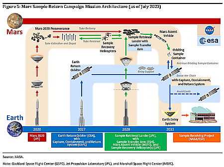
The present plan for Mars Sample Return
In issuing yesterday its reponse [pdf] to the February 28, 2024 audit [pdf] by NASA’s inspector general (IG) of its Mars Sample Return mission (MSR), NASA has admitted that its Mars Sample Return project needs new ideas and major changes. From the press release:
“The bottom line is, an $11 billion budget is too expensive, and a 2040 return date is too far away,” said [NASA administrator Bill] Nelson.
The agency will today issue a call for proposals from the private sector for alternative ideas for picking up the samples on Mars and getting them up into orbit.
This NASA response to the IG report however changes little else in overall project, and almost certainly will not succeed in either reducing cost or shortening the timeline in any way.
» Read more


