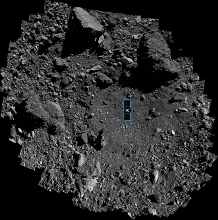
The sample site on Bennu, with OSIRIS-REx
superimposed for scale. Click for full image.
First, I hope my readers will notice that — unlike NASA and the entire press — I make no mention in my headline above of the discovery of a “mix of life’s ingredients” or “the key building blocks of life” from the samples brought back by the probe OSIRIS-REx from the asteroid Bennu.
This is the game NASA does all the time, to hint at the discovery of life when this is not the real discovery. NASA does it because it knows that if you hint at such a discovery, the press will go crazy and give you lots of press.
The real news from the two papers published this week, available here and here, however, is more fundamental. Before the samples from Bennu and Ryugu (brought back by the Japanese probe Hayabusa-2) had arrived, our understanding of the make-up and chemistry of the early solar system was very incomplete and badly biased. The only asteroid samples we had of carbonaceous chondrite asteroids, the most primitive and fragile carbon-rich asteroids in the solar system, had came from meteorites that had survived the journey through the Earth’s atmosphere. Thus, the only material that survived was robust enough to do so. The more fragile molecules however were always destroyed and thus missing from meteorites, even though it was very clear from spectroscopy of these asteroids in the solar system that such molecules did exist, and likely formed the majority of these asteroids’ make-up.
Thus, though carbonaceous chondrite asteroids represent the early solar system, our understanding of them was warped and very incomplete. The whole point of both missions to Bennu and Ryugu was to fill in this data, to get a more complete census of the real make-up of the early solar system.
The two papers published this week have given us that. That’s their real discovery.
» Read more