
Why I went to Belize
There are many reasons cavers decide to go to faraway places across the globe during their vacations. Some do it because they want to get out of the office. Some go because they like to see exotic sights and strange places well off the beaten path. Some go, like me, because they want the chance to see something new and unexplored. And we all do it because it is fun!
One doesn’t have to go to Belize to get these benefits. I could have traveled to England, Mexico, Hawaii, or any one of several dozen other countries to see the exotic, the new, and the unexplored. In fact, I have already done so in Russia, Ukraine, Germany, and Czechia (the new official name of the Czech Republic). Belize however was relatively close, the local population spoke English, I had never been there before, and most important, someone else was organizing things! When David and Eleanor Larson invited me to join their Belize project I decided this was a great opportunity to visit a strange and new place with a minimum of aggravation or planning. They had already done it, and I merely had to sign up and agree to do whatever their project needed doing. So, off I went.
Upon arrival, I soon discovered several very important additional reasons why this cave project exists. First there are the caves. They are grand and beautiful things, with very vast chambers filled with delicate and rare formations. The picture below, taken by fellow caver Laura Sangiala, shows one wall of the gigantic entrance room of one cave.
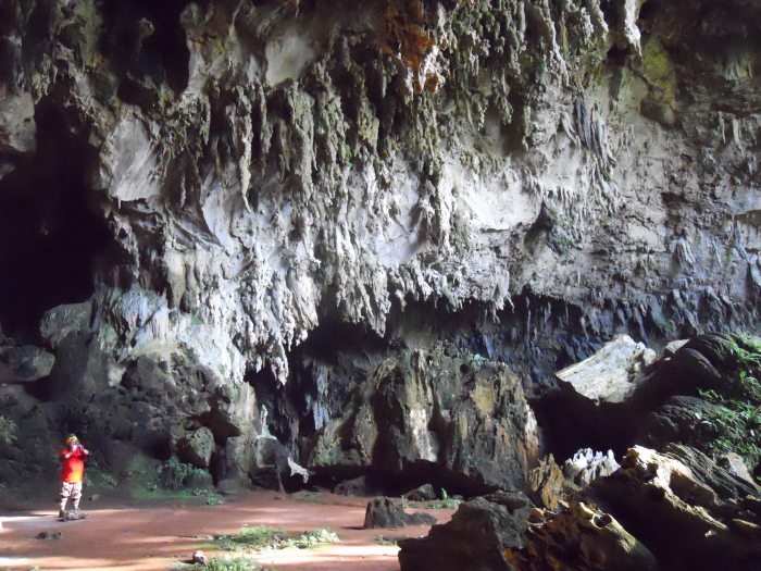
Caver Larry Zimmer can be seen on the left. The entrance itself, out of view on the right, is an opening up a 100 foot slope probably 200 feet across. To the left the cave disappears into darkness in a meandering passage about 100 feet wide with a 60-foot-wide river flowing through it
Mapping these caves makes it possible to know what is there, and thus easier to protect. The Larsons’ project has been doing this now for Belize’s Institute of Archaeology for more than a decade.
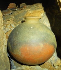
Then there are the things one finds in these caves. Belize as well as Guatemala next door were part of the great Mayan empire, and during its height a thousand years ago caves were an important part of that civilization’s religious beliefs. Thus, the caves routinely have many important archaeological artifacts that must be protected and preserved, such as the almost intact pot shown in the photo on the right, with pottery shards behind it (photo by Laura Sangiala), found in one of the caves I was surveying this past week. Mapping these artifacts provides scientists a detailed baseline of data for future research, while also providing the Institute the information it needs to better manage these resources.
Protecting and documenting the caves and their archaeology is the most obvious reason to doing this work, but there is another reason that is actually far more fundamental. Belize is a somewhat poor country whose most important resource is tourism. Without its interesting historical, geological, and archaeological sites, the people of Belize would lose a significant source of income, and so, it is in their own self-interest to protect these caves.
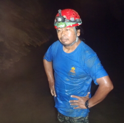
The photo on the right is of tour guide Marcus Cucul (photo by caver Don Smith), who accompanied us on almost every cave trip. Marcus, however, was not there to survey. Instead, he and several other tour guides came each time to lay down flagging tape and carefully mark trails so that travel by future tour guides would be better controlled, thereby better protecting each cave’s formations and archaeology. Marcus, like the other tour guides, runs a tour company, Maya Guide Adventures, and for that company to prosper he and his fellow guides have to manage the caves responsibly so that they will remain beautiful and interesting to see for many years into the future.
In fact, my experience in Belize once again reaffirmed my belief that private property and profit are the best ways to protect the environment. Because the caves have a financial value to these tour guides, there is a practical financial reason for the guides to protect them. If these guides were forbidden to lead cave tours, they would have no incentive to protect them, and the resulting random and uncontrolled visits would result in the caves’ destruction.
Because Belize’s law puts the ownership of all caves under the jurisdiction of the Institute of Archaeology, which generally lacks the resources to protect them all, this work by the tour guides is essential. For example, Barton Creek Cave is a major tourist river cave that requires a canoe to see. Though the property surrounding the entrance is privately owned, the landowner, Mike Bogart, cannot prevent access to the cave to others. He offers tours, using the canoes he provides, but others can do the same and access the cave by canoeing up the river past his property. They need only get a government permit.
Thus, under this socialized system, with no single owner responsible for each cave, the only way the caves can be protected is for the tour guides and operators to band together to protect the caves themselves. In fact, their effort to flag the trails these past few weeks was begun expressly because they all saw the damage that uncontrolled visitation was causing, and wanted to stop it
Hopefully, their effort will bear fruit, and the caves and their guides’ livelihoods will prosper for years to come. And if the cave maps we Americans produce can help contribute to that success, then my short trip to Belize will have accomplished a lot more than provide me a few days of vacation pleasure.

On Christmas Eve 1968 three Americans became the first humans to visit another world. What they did to celebrate was unexpected and profound, and will be remembered throughout all human history. Genesis: the Story of Apollo 8, Robert Zimmerman's classic history of humanity's first journey to another world, tells that story, and it is now available as both an ebook and an audiobook, both with a foreword by Valerie Anders and a new introduction by Robert Zimmerman.
The ebook is available everywhere for $5.99 (before discount) at amazon, or direct from my ebook publisher, ebookit. If you buy it from ebookit you don't support the big tech companies and the author gets a bigger cut much sooner.
The audiobook is also available at all these vendors, and is also free with a 30-day trial membership to Audible.
"Not simply about one mission, [Genesis] is also the history of America's quest for the moon... Zimmerman has done a masterful job of tying disparate events together into a solid account of one of America's greatest human triumphs."--San Antonio Express-News
Not to mention one’s life is a finite slice of time. Do what you enjoy as often as is feasible because all of our lives do eventually end.
Mr. Z.,
I’d be interested in any tidbits you might want to share about the actual mapping of these Caves. When you say you folks were surveying (and mapping) the caves, do you literally mean surveying, as in land-surveying?
Has anyone ever scanned the interior using LIDAR? –Modern digital surveying-equipment is absolutely amazing–with a LIDAR instrument, you can create ‘point-cloud’ maps that are practically photographic in visual quality & the raw data consists of the X,Y,Z, & distance, elevation, and angle-coordinates. (also allows you to accurately measure impossible to reach places.)
(Most familiar with terrestrial Land Surveying myself—Electronics, GPS, and Drones have revolutionized the entire Surveying Profession—less familiar with how that has impacted underground surveying.)
Cave surveying normally involves a three person team, one to sketch (me) and two to do instruments. We use a compass, clinometer, and tape, and actually measure from point to point. The sketcher than draws the cave around those points, using a variety of mapping symbols that have been developed since the 1960s to indicate cave features.
There are a number of people playing with using lidar, but it is generally impractical and much slower. It also produces files that no one else can generally use. It also forgets the fundamental reason one maps a cave, which is to produce a useful document edited to indicate the caves most important features. Lidar records everything, which might sound good but in the end includes a lot of useless information.
In Belize instead of compass, clinometer, and tape we used an instrument called a Disto-X, which gives you distance, azimuth, and inclination with a single press of a button. Unfortunately, it requires a lot of calibration, and upon returning home and looking at the data I discovered that one Disto-X was not calibrated correctly. About a dozen survey shots must be redone.
Cool! (thank you)