Martian badlands
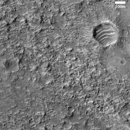
The photo to the right is a small section cropped from an image taken by the high resolution camera on Mars Reconnaissance Orbiter (MRO) on January 2, 2020. It shows the rough, cratered southern highlands dubbed Tyrrhena Terra that lie between the low Isidis Basin to the north and Mars’ deepest basin, Hellas, to the south.
The image was taken not because any specific scientific request, but because MRO was doing spectroscopy over this area and it made sense to also take a photograph. Comparing the photograph with the spectroscopic data allows scientists to better understand that spectroscopy.
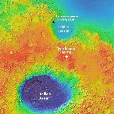
The white cross in the map below shows the location of this image. The map itself covers latitudes from 40 degrees north to 55 degrees south.

The cratered roughness of this region means that there is a lot of variety in the surface minerals, including the presence of what scientists called hydrated minerals, formed in the presence of water and therefore having the elements of water (hydrogen and oxygen) locked within their molecular structure. Data has so far found these hydrated materials on the inner rims of craters, which suggest they come from ancient terrains that were exposed by the impacts.
The numerous craters are also traps for sand, as can be seen by the dunes in the crater in the upper right.
To me, the roughness of this terrain is its most significant feature. Located in the equatorial regions, the data has so far found little obvious evidence of ice or water, making it less appealing as a site for settlement. The roughness is an even bigger strike against this territory. Even if we did eventually find ice here, getting to and from this region will discourage exploration. There are many other places on Mars where water is well documented, near the surface, and where landing and moving about is far less difficult.
So, let me predict the far future, when humans have built many colonies on Mars. While the big cities will be in the wet northern plains, preferably at spots closest to the equator, this region will remain a rural backwater, where few people live or work.
On Christmas Eve 1968 three Americans became the first humans to visit another world. What they did to celebrate was unexpected and profound, and will be remembered throughout all human history. Genesis: the Story of Apollo 8, Robert Zimmerman's classic history of humanity's first journey to another world, tells that story, and it is now available as both an ebook and an audiobook, both with a foreword by Valerie Anders and a new introduction by Robert Zimmerman.
The print edition can be purchased at Amazon or from any other book seller. If you want an autographed copy the price is $60 for the hardback and $45 for the paperback, plus $8 shipping for each. Go here for purchasing details. The ebook is available everywhere for $5.99 (before discount) at amazon, or direct from my ebook publisher, ebookit. If you buy it from ebookit you don't support the big tech companies and the author gets a bigger cut much sooner.
The audiobook is also available at all these vendors, and is also free with a 30-day trial membership to Audible.
"Not simply about one mission, [Genesis] is also the history of America's quest for the moon... Zimmerman has done a masterful job of tying disparate events together into a solid account of one of America's greatest human triumphs."--San Antonio Express-News
The photo to the right is a small section cropped from an image taken by the high resolution camera on Mars Reconnaissance Orbiter (MRO) on January 2, 2020. It shows the rough, cratered southern highlands dubbed Tyrrhena Terra that lie between the low Isidis Basin to the north and Mars’ deepest basin, Hellas, to the south.
The image was taken not because any specific scientific request, but because MRO was doing spectroscopy over this area and it made sense to also take a photograph. Comparing the photograph with the spectroscopic data allows scientists to better understand that spectroscopy.
The white cross in the map below shows the location of this image. The map itself covers latitudes from 40 degrees north to 55 degrees south.

The cratered roughness of this region means that there is a lot of variety in the surface minerals, including the presence of what scientists called hydrated minerals, formed in the presence of water and therefore having the elements of water (hydrogen and oxygen) locked within their molecular structure. Data has so far found these hydrated materials on the inner rims of craters, which suggest they come from ancient terrains that were exposed by the impacts.
The numerous craters are also traps for sand, as can be seen by the dunes in the crater in the upper right.
To me, the roughness of this terrain is its most significant feature. Located in the equatorial regions, the data has so far found little obvious evidence of ice or water, making it less appealing as a site for settlement. The roughness is an even bigger strike against this territory. Even if we did eventually find ice here, getting to and from this region will discourage exploration. There are many other places on Mars where water is well documented, near the surface, and where landing and moving about is far less difficult.
So, let me predict the far future, when humans have built many colonies on Mars. While the big cities will be in the wet northern plains, preferably at spots closest to the equator, this region will remain a rural backwater, where few people live or work.
On Christmas Eve 1968 three Americans became the first humans to visit another world. What they did to celebrate was unexpected and profound, and will be remembered throughout all human history. Genesis: the Story of Apollo 8, Robert Zimmerman's classic history of humanity's first journey to another world, tells that story, and it is now available as both an ebook and an audiobook, both with a foreword by Valerie Anders and a new introduction by Robert Zimmerman.
The print edition can be purchased at Amazon or from any other book seller. If you want an autographed copy the price is $60 for the hardback and $45 for the paperback, plus $8 shipping for each. Go here for purchasing details. The ebook is available everywhere for $5.99 (before discount) at amazon, or direct from my ebook publisher, ebookit. If you buy it from ebookit you don't support the big tech companies and the author gets a bigger cut much sooner.
The audiobook is also available at all these vendors, and is also free with a 30-day trial membership to Audible.
"Not simply about one mission, [Genesis] is also the history of America's quest for the moon... Zimmerman has done a masterful job of tying disparate events together into a solid account of one of America's greatest human triumphs."--San Antonio Express-News


Are there Orbiter images of “the face on Mars” site?
Edward_2,
Yes. You can see it and other images at https://en.m.wikipedia.org/wiki/Cydonia_(Mars)
Edward, yes, the “face on Mars” site was checked first thing some years ago. There was nothing there but some hills. The “face” was a combination of using (by today’s standards) a relatively low resolution camera and suggestive shadow effects.
All the brouhaha about the face is perhaps not so surprising. I remember seeing, back in the early 1970s, prior to the Viking probes being launched to Mars, a documentary given by none other than Carl Sagan, where he showed imagery taken by some of the earlier Mariner probes that seemed to show what looked like pyramids on Mars and other “suggestive” looking artifacts on the surface of that planet. Needless to say, after Viking you didn’t hear much about pyramids on Mars.
Nothing would have made me happier than if some unambiguous evidence of intelligence on Mars had been found. But sadly, especially with the advanced high resolution cameras we have orbiting Mars now, nothing has been found.
The Expanse
Bobbie Arrives on Earth
“Earth’s Gravity is Difficult on the Martian Physique…”
https://youtu.be/xD8i3vGY4Uw
3:50
If Martian settlement works out, I can foresee, a few decades hence, the Martians sending heavy equipment out to Cydonia to turn the “not a face” into an actual face – Elon Musk’s.