
More evidence of ample shallow ice in Martian mid-latitudes
In a new paper released this week, scientists using instruments on both Mars Odyssey and Mars Reconnaissance Orbiter have found more evidence that there is a large amount of widespread ice close to the surface in the Martian mid-latitudes. As the scientists note in their abstract:
We show that water ice is present sometimes just a few centimeters below the surface, at locations where future landing is realistic, under mobile material that could easily be moved around. This ice could be exploited on‐site for drinking water, breathable oxygen, etc., at a much lower cost than if brought from Earth.
They deduced this by looking at how that ice would change the seasonal temperatures in the atmosphere directly above. Cooler regions suggested more ice close to the surface, while warmer regions suggested either no ice or ice deep below the surface. While this approach is indirect and did not directly detect ice, their conclusions match perfectly with all previous research. Below is a global map of Mars taken from the paper’s the supplementary material [docx file], reduced and annotated by me, showing the regions that seem to have ample shallow ice. Regular readers of Behind the Black will instantly recognize these locations.
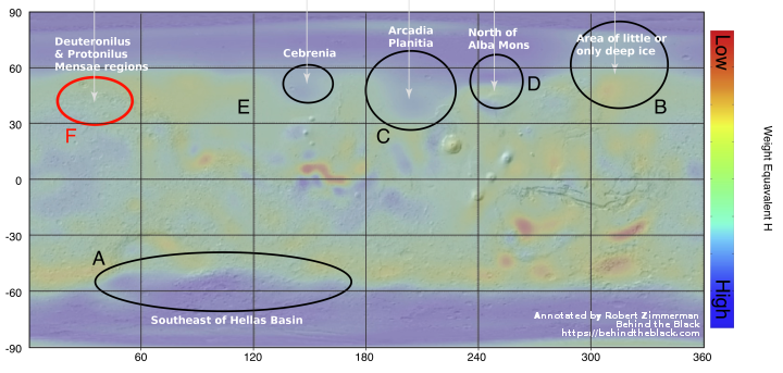
Five regions are named where shallow ice is suspected. Four have previously been subjects of news stories here about possible water.
A. Southeast of Hellas Basin. This is the same region where other scientists have found numerous exposed scarps of ice.
C. Arcadia Planitia. This is SpaceX’s first choice as its candidate landing site, first with Red Dragon and now with Starship.
E. Cebrenia. Though I am unfamiliar with this named region, the map indicates that it corresponds closely with Utopia Basin, a place where ample evidence of ice has been found repeatedly. See here and here for only two examples.
F. Deuteronilus and Protonilus Mensae These regions of chaos terrain are places where evidence has been found of numerous buried inactive glaciers.
The last region, north of Alba Mons, is also near where Phoenix landed and found ice just below the surface.
If this paper was the only evidence of shallow ice at these locations I would consider the conclusion very uncertain, considering the indirect methods used. Combined however with all the other research that aligns so well, it would seem this paper confirms the rest of the research. These are places where we will find water ice on Mars, close to the surface and easily accessible.

On Christmas Eve 1968 three Americans became the first humans to visit another world. What they did to celebrate was unexpected and profound, and will be remembered throughout all human history. Genesis: the Story of Apollo 8, Robert Zimmerman's classic history of humanity's first journey to another world, tells that story, and it is now available as both an ebook and an audiobook, both with a foreword by Valerie Anders and a new introduction by Robert Zimmerman.
The print edition can be purchased at Amazon or from any other book seller. If you want an autographed copy the price is $60 for the hardback and $45 for the paperback, plus $8 shipping for each. Go here for purchasing details. The ebook is available everywhere for $5.99 (before discount) at amazon, or direct from my ebook publisher, ebookit. If you buy it from ebookit you don't support the big tech companies and the author gets a bigger cut much sooner.
The audiobook is also available at all these vendors, and is also free with a 30-day trial membership to Audible.
"Not simply about one mission, [Genesis] is also the history of America's quest for the moon... Zimmerman has done a masterful job of tying disparate events together into a solid account of one of America's greatest human triumphs."--San Antonio Express-News
Erratum: the map says (A) Southwest of Hellas Basin while the text says (A) Southeast of Hellas Basin.
Error fixed in the text. Thanks.
This was a 2020 post. It appears you are going through all my older Mars posts. I am sure the goal is NOT to find errors, but for real research. Can you give details?
Yes, happy to go into it. I’m not reviewing all of your Mars postings, mind you, interesting as those are (I generally read those as they come in), but specifically I’m looking at the Hellas Basin region, for which I’m drawing a detailed gis (Qgis) map, mostly based in the Mars 200m blended DEM (digital elevation model).
While my Hellas map’s main purpose is to illustrate what an interesting sea filling it with (probably southern polar cap) water to a particular level (-6625m w.r.t. the martian datum) would produce, I’m also including select HiRISE pics of particular features in the region—to find which in part I’m referencing your postings, thank you very much, searching for (e.g.) “glacier” or “Hellas”.
The HiRISE pics are very interesting, as you know, especially I’m finding when seen in the topographic context of their wider locality as well as overlaid with contour lines. It’s an adventure of exploration, which I thank you for inspiring.
One thing I’ve noticed about the HiRISE archive (available at uahirise.org) is the highly detailed .JP2 files linked to there—since around 2021—load automatically in gis (or at least Qgis), no georeferencing (laying out their coordinate extents) required. But for files posted prior to that, annoyingly laborious manual georeferencing has been necessary (at least in Qgis). But in this regard I just finished putting together a Python routine which automatically georeferences those earlier .JP2’s (based on the coordinate limits in the .LBL file), which ought to now save some effort in this regard in the future.
Thanks—hugely—again!