
Strange unexplained polarization shifts in M87’s supermassive black hole
Click for original image.
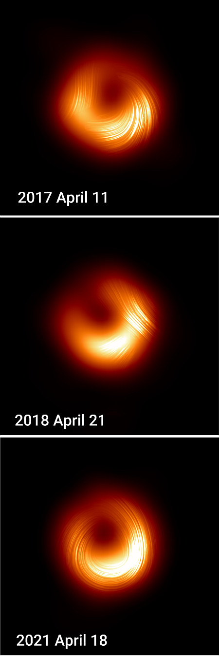
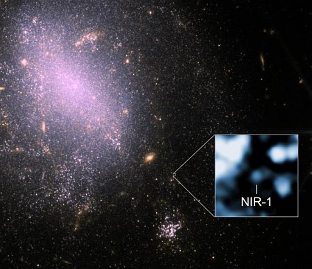
Using the Event Horizon Telescope (EHT), astronomers have detected unexpected and so far unexplained polarization shifts in the supermassive black hole that resides at the center of the galaxy M87, located 55 million light years away.
That black hole is estimated to have a mass six billion times that of our Sun, and was the first ever imaged by EHT. By using observations made in 2017, 2018, and 2021, as shown in the images to the right, found its magnetic field changing in unexpected ways.
Between 2017 and 2021, the polarization pattern flipped direction. In 2017, the magnetic fields appeared to spiral one way; by 2018, they settled; and in 2021, they reversed, spiraling the opposite direction. Some of these apparent changes in the polarization’s rotational direction may be influenced by a combination of internal magnetic structure and external effects, such as a Faraday screen. The cumulative effects of how this polarization changes over time suggests an evolving, turbulent environment where magnetic fields play a vital role in governing how matter falls into the black hole and how energy is launched outward.
The changes were more puzzling in that the size of the black hole’s event horizon, the ring surrounding it, did not change. According to the scientists, this suggests “magnetized plasma swirling near the event horizon is far from static; it’s dynamic and complex, pushing our theoretical models to the limit.”
That the magnetic field flipped polarity however should not be surprising to scientists. Consider the same polarity flips we see in our own Sun every eleven years. It should be expected that the magnetic field around a super massive black hole would be equally variable, if not more so.
The problem is that there remains no understanding about why such changes happen. We know the magnetic field exists. We know it flips polarity. With the Sun we know it does so regularly every eleven years. Why it does so however remains unknown, though there are theories. With M87 the data is far less certain.
Tracking the changes at M87 however should help us build our knowledge base so that someday we might finally grasp those fundamentals.

Click for original image.
Using the Event Horizon Telescope (EHT), astronomers have detected unexpected and so far unexplained polarization shifts in the supermassive black hole that resides at the center of the galaxy M87, located 55 million light years away.
That black hole is estimated to have a mass six billion times that of our Sun, and was the first ever imaged by EHT. By using observations made in 2017, 2018, and 2021, as shown in the images to the right, found its magnetic field changing in unexpected ways.
Between 2017 and 2021, the polarization pattern flipped direction. In 2017, the magnetic fields appeared to spiral one way; by 2018, they settled; and in 2021, they reversed, spiraling the opposite direction. Some of these apparent changes in the polarization’s rotational direction may be influenced by a combination of internal magnetic structure and external effects, such as a Faraday screen. The cumulative effects of how this polarization changes over time suggests an evolving, turbulent environment where magnetic fields play a vital role in governing how matter falls into the black hole and how energy is launched outward.
The changes were more puzzling in that the size of the black hole’s event horizon, the ring surrounding it, did not change. According to the scientists, this suggests “magnetized plasma swirling near the event horizon is far from static; it’s dynamic and complex, pushing our theoretical models to the limit.”
That the magnetic field flipped polarity however should not be surprising to scientists. Consider the same polarity flips we see in our own Sun every eleven years. It should be expected that the magnetic field around a super massive black hole would be equally variable, if not more so.
The problem is that there remains no understanding about why such changes happen. We know the magnetic field exists. We know it flips polarity. With the Sun we know it does so regularly every eleven years. Why it does so however remains unknown, though there are theories. With M87 the data is far less certain.
Tracking the changes at M87 however should help us build our knowledge base so that someday we might finally grasp those fundamentals.


