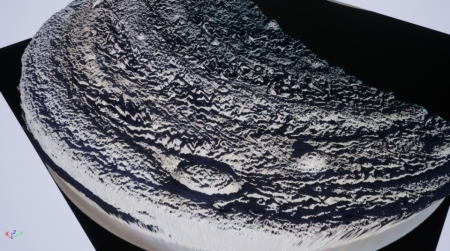
Io volcano erupts like Ol’ Faithful
Having determined that Io’s largest volcano appears to erupt on a regularly schedule, scientists have predicted that a new eruption should occur sometime in the next week or so.
The volcano Loki is expected to erupt in mid-September, 2019, according to a poster by Planetary Science Institute Senior Scientist Julie Rathbun presented today.
“Loki is the largest and most powerful volcano on Io, so bright in the infrared that we can detect it using telescopes on the Earth,” Rathbun said. Based on more than 20 years of observations, Loki undergoes periodic brightenings when it erupts on a relatively regular schedule. In the 1990s, that schedule was approximately every 540 days. It currently appears to be approximately every 475 days. Rathbun discovered the 540-day periodicity, described in her 2002 paper “L. Loki, Io: A periodic volcano” that appeared in Geophysical Research Letters.
These same scientists successfully predicted Loki’s last eruption based on this data, but also warn that there is no guarantee the volcano will do what they say. As stock brokers are required to say, past performance is no guarantee of future results.