Some new “What the heck?” geology on Mars

What the heck is going on here?
Click for original image.

Cool image time! The picture to the right, rotated, cropped, reduced, and enhanced to post here, was taken on April 21, 2024 by the high resolution camera on Mars Reconnaissance Orbiter (MRO).

My first reaction on seeing this picture was to scratch my head? What am I looking at? Are those fluted dark features going downhill to the south, or uphill to the north? What are they? Are they slope streaks? Avalanches? How do they relate to the flat-topped ground in the middle of the picture?

I have made it easier for my readers to interpret the picture by adding the “low” and “high” markers. We are looking at two parallel thin mesas about 1,400 feet high, with the saddle between them only dropping about 350 feet.

But what about the dark fluted features? To understand what these are requires more information.
» Read more

2 comments

Perservance looks back from on high

Perservance's view looking back down Neretva Vallis
Click for original image.

Cool image time! The picture above, cropped to post here, was taken on September 9, 2024 by the left navigation camera on the Mars rover Perseverance, looking east and back along the route from which the rover had come.

The view is somewhat more spectacular than most Perseverance images because the rover took it during its on-going climb up unto the rim of Jezero Crater, as shown by the overview map below. The blue dot marks Perseverance’s present position, while the yellow lines indicate the area covered by the picture above, taken several days earlier.

The haze in the picture also suggests that the local dust storm first noted in late August might be clearing somewhat. This isn’t certain, however, as the previous picture was using the rover’s high resolution camera to look at distant hills (thus more obscured), while the picture above was taken by the left navigation camera looking more widely and at nearer objects.

Overview map
Click for interactive map.

1 comment

New gravity map of Mars released

New global map of Mars gravity field
Click for original image.
Using both seismological data compiled over four years by the InSight Mars lander as well tiny changes in the orbits of Martian satellites, scientists have now created a global gravity map of the red planet, indicating the regions below the surface that are either low or high density.

That map is above, annotated by me to indicate some of Mars’ major surface features.

The density map shows that the northern polar features are approximately 300-400 kg/m3 denser than their surroundings. However, the study also revealed new insights into the structures underlying the huge volcanic region of Tharsis Rise, which includes the colossal volcano, Olympus Mons.

Although volcanoes are very dense, the Tharsis area is much higher than the average surface of Mars, and is ringed by a region of comparatively weak gravity. This gravity anomaly is hard to explain by looking at differences in the martian crust and upper mantle alone. The study by Dr Root and his team suggests that a light mass around 1750 kilometres across and at a depth of 1100 kilometres is giving the entire Tharsis region a boost upwards. This could be explained by huge plume of lava, deep within the martian interior, travelling up towards the surface.

I once again note that the largest impact basin on Mars, Hellas Basin, sits almost exactly on the planet’s far side from Tharsis, and appears to have a light density. This contrast once again makes me wonder if the origin of that impact and the Tharsis Bulge are linked.

13 comments

A fluted mesa on Mars

A fluted mesa on Mars
Click for original image.

Cool image time! The picture to the right, cropped, reduced, and sharpened to post here, was taken on July 9, 2024 by the high resolution camera on Mars Reconnaissance Orbiter (MRO). It shows what the science team labels a “silica-rich mound”, as indicated by the bright streaks on all the high ridge points.

The flat-topped mesa on the right drops about 200 feet to the valley floor. The rims of that depression to the west rise about 50+ feet higher, while mesa nose in the upper left rising another 50+ feet more.

Was the depression caused by an impact? If so, the landscape has changed radically since that impact occurred, with most of the surrounding terrain eroded away. The two flat-topped mesas hint at the ancient surface when that impact occurred.

A wider view however raises questions about this impact theory.
» Read more

1 comment

Scientists re-create on Earth the sublimation of Mars’s winter mantle of dry ice

Spiders created on Earth
Click for original image.

Scientists have successfully re-created on Earth the process on Mars that creates the unique “spider” formations seen in the the Martian south pole region, produced when the winter mantle of dry ice begins to sublimate away into a gas.

The study confirms several formation processes described by whatโ€™s called the Kieffer model: Sunlight heats the soil when it shines through transparent slabs of carbon dioxide ice that built up on the Martian surface each winter. Being darker than the ice above it, the soil absorbs the heat and causes the ice closest to it to turn directly into carbon dioxide gas โ€” without turning to liquid first โ€” in a process called sublimation (the same process that sends clouds of โ€œsmokeโ€ billowing up from dry ice). As the gas builds in pressure, the Martian ice cracks, allowing the gas to escape. As it seeps upward, the gas takes with it a stream of dark dust and sand from the soil that lands on the surface of the ice.

At the south pole, the ground below the mantle is stable enough that each winter the trapped CO2 gas follows the same path to the same points where the dry ice cracks, slowly creating “tributaries” that combine to form the spider formations.

The picture to the right, cropped, reduced, and sharpened to post here, comes from figure 9 of the paper [pdf]. It shows the lab-created spiders formed by this simulated process, thereby confirming this hypothesis about how the spiders form.

0 comments

The reasons why Mars two polar caps are so different

The Martian north pole
The Martian north pole.

The Martian south pole
The Martian south pole.

Elevation scale bar
What the colors mean in terms of elevation

A new paper, in review for the past year, has now been published describing the differences between the north and south poles of Mars, the most fundamental of which involve the planet’s orbit and the different elevations of the two poles, with the south pole three to six miles higher in altitude (as indicated by the colors on the maps to the right).

The cumulative data has allowed the researchers to explain why — when the thin winter cap of dry ice sublimates away in the spring — the process at the south pole results in spiderlike features that get enhanced from year to year, but in the north pole that sublimation process produces no such permanent features.

In both cases, the spring sunlight passes through the clear winter mantle of dry ice to heat its base. The sublimated trapped CO2 gas builds up, until the pressure causes the mantle to crack at weak spots. In the south that trapped gas flows uphill each spring along the same paths, carving the riverlike tributaries dubbed unofficially as “spiders” and officially as “araneiform terrain.”

Geophysicist Hugh Kieffer described that process in 2006. A few years later, [Candice] Hansen [the new paper’s lead author] followed up with her own model for the north polar cap, which also displays fans in the spring.

She found that the same phenomena occur in the north, but rather than relatively flat terrain, these processes play out across sand dunes. โ€œWhen the Sun comes up and begins to sublimate the bottom of the ice layer, there are three weak spots โ€“ one at the crest of the dune, one at the bottom of the dune where it meets the surface and then the ice itself can crack along the slope,โ€ Hansen said. โ€œNo araneiform terrain has been detected in the north because although shallow furrows develop, the wind smooths the sand on the dunes.โ€

There is also a lot more dust in the north, including a giant sea of dunes that circles the polar cap. In addition, the northern winter is shorter due to the planet’s orbit, and takes place during the annual dust storm season, causing there to be more dust concentrated within the northern ice. All of these factors make the the dunes and general surface in the north is more easily smoothed by the wind.

0 comments

A cloud atlas of Mars

Different clouds on Mars interacting
Click for original image.

Using data obtained from one of the instruments on the European Space Agency’s (ESA) Mars Express orbiter, scientists have now published an atlas of the clouds of Mars and made it available to the public.

The picture to the right, cropped, reduced, and sharpened to post here, is just one example of the images in the atlas. From the caption:

This image displays two atmospheric phenomena: the white curved lines are gravity wave clouds, while the brown areas are dust lifted from the ground by wind. The colour shift visible in the dust lifting event might be indicative of very fast winds, a phenomenon currently under investigation by other members of the team.

The atlas contains more than 300 images of various Martian cloud formations, from the one to the right to images of cirrus clouds on the top of Olympus Mons, Mars’ largest volcano. You can download it here (the file is a very large spreadsheet).

0 comments

A crack on Mars more than 600 miles long

A crack on Mars more than 600 miles long
Click for original image.

Cool image time! The picture to the right, cropped and reduced to post here, was taken on March 29, 2024 by the high resolution camera on Mars Reconnaissance Orbiter (MRO).

The science team labels this “troughs in Labeatis Fossae.” On Mars, the word “fossae” is used to indicate regions where there are a lot of parallel fissures. Though there are a few examples where such fissures might have been caused by the movement of ice or water, carving out the channel, in almost all cases this is not the cause. Instead, fossae are usually formed when the surface stretches, either because underground upward pressure pulls it apart, or because there is a sideways spread at the surface. The resulting cracks are generally considered what geologists call “grabens,” depressions caused at faultlines when the ground on either side moves apart in some manner.

In this case the break in the trough proves this is a graben, though why it broke at this spot is not clear.
» Read more

0 comments

Musk: First unmanned Mars Starship targeting a ’26 launch

The prime and secondary Martian landing sites for Starship

According to a tweet yesterday by Elon Musk, SpaceX is aiming for a 2026 launch of its first unmanned Starship to Mars.

The first Starships to Mars will launch in 2 years when the next Earth-Mars transfer window opens. These will be uncrewed to test the reliability of landing intact on Mars. If those landings go well, then the first crewed flights to Mars will be in 4 years.

Flight rate will grow exponentially from there, with the goal of building a self-sustaining city in about 20 years.

The graphic to the right indicates the planned landing zone, with the four red dots the four prime locations. Three of the four are very flat, though they also appear to have a lot of very near-surface ice, accessible simply by digging a shovel into the ground. Attempting to land at any will definitely test Statship’s ability to land on Mars intact. A global map of Mars is shown below, showing the location of this landing zone. The map shows where researchers believe the saltiest water on Mars would be. According to this data, in the Starship landing zone some of that near-surface ice will turn to liquid brine a little less than one percent of each year. Otherwise it will be more easily processed for drinking and fuel.

As always with these ambitious predictions, Musk is aiming high, with the likelihood that this first mission will not make that ’26 date. At the same time, he is making it very clear that a first attempt will certainly happen by ’28.

I also think the timing of this announcement is intriguing, coming one day after NASA was forced to cancel the launch in October of two Mars orbiters because it could not be certain Blue Origin would have the New Glenn rocket ready on time. Musk’s response is to say that SpaceX is now about to begin regularly privately funded and privately built missions to Mars, on a schedule, essentially asking: “Which company would you choose to do things in space?”
» Read more

15 comments

NASA cancels launch of its two Escapade Mars Orbiters due to Blue Origin delays

After reviewing the status of launch preparations by Blue Origin of its New Glenn rocket, NASA today decided to cancel the launch because it appeared that Blue Origin would not be able to meet the October 13-21 launch window for sending the agency’s two Escapade orbiters to Mars.

NASA announced Friday it will not fuel the two ESCAPADE (Escape and Plasma Acceleration and Dynamics Explorers) spacecraft at this time, foregoing the missionโ€™s upcoming October launch window. While future launch opportunities are under review, the next possible earliest launch date is spring 2025.

The agencyโ€™s decision to stand down was based on a review of launch preparations and discussions with Blue Origin, the Federal Aviation Administration, and Space Launch Delta 45 Range Safety Organization, as well as NASAโ€™s Launch Services Program and Science Mission Directorate. The decision was made to avoid significant cost, schedule, and technical challenges associated with potentially removing fuel from the spacecraft in the event of a launch delay, which could be caused by a number of factors.

The press release of course is vague about why the launch has been canceled, but the reasons are obvious if you have been paying attention. Though Blue Origin has clearly been making progress towards the first launch of New Glenn, recent reports suggested strongly that it would be impossible for it to assemble the rocket, integrate the two orbiters, and get everything on the launchpad on time.

Rocket Lab, which built the orbiters, of course fully supported the decision, though that company very much wanted it to fly now to demonstrate its ability to make low cost smallsat planetary probes.

This failure of Blue Origin to meet this deadline speaks poorly of the company. To serve the satellite and especially the planetary research community rocket companies must be able to launch on schedule and on time. Blue Origin has failed to do so in this case. It appears Jeff Bezos needs to ramp up the pressure on his moribund company to finally get it to perform in the manner he desires, as described by Bezos himself recently.

3 comments

Dust storm in Jezero Crater

Overview map
Click for interactive map.

Dust storm in Jezero Crater
Click for original image.

An update today from the science team for the Mars rover Perseverance included the picture to the right, cropped, reduced, and sharpened to post here and taken by the rover on August 20, 2024. As the update noted,

It is dust-storm season on Mars! Over the past couple of weeks, as we have been ascending the Jezero Crater rim, our science team has been monitoring rising amounts of dust in the atmosphere. This is expected: Dust activity is typically highest around this time of the Martian year (early Spring in the northern hemisphere). The increased dust has made our views back toward the crater hazier than usual, and provided our atmospheric scientists with a great opportunity to study the way that dust storms form, develop, and spread around the planet.

The yellow lines on the overview map above indicate the approximate direction of the photo. The blue dot marks Perseverance’s present position, with the red dotted line its planned route and the white dotted line its actual travels.

At the moment this dust storm is localized to the region around Jezero Crater, and based on past seasonal dust storms, is not expected to expand to a global storm.

1 comment

Curiosity takes another look south into Gediz Vallis

Looking south inside Gediz Vallis

Overview map
Click for interactive map.

Cool image time! As it has been more than a month since I lasted posted a cool landscape image from the Mars rover Curiosity, it seemed time to upload the panorama above, changed not at all to post here and taken by the rover’s right navigation camera on September 4, 2024.

The blue dot on the overview map to the right marks Curiosity’s present position. The yellow lines indicate the approximate direction of the panorama’s view. The red dotted line indicates Curiosity’s planned route, with the white dotted line marking its actual path. After spending most of the last month on a drilling campaign at the southernmost point of its travels, the science team had Curiosity retreat northward, where it will eventually head uphill to the west to swing around that mountain to head south in a parallel canyon.

The panorama looks into the slot canyon Gediz Vallis that Curiosity has been exploring for a little more than a year. The light colored mountains are what the scientists call the sulfate-bearing unit, a region on the higher slopes of Mount Sharp that is likely to have a very alien geology and chemistry, when compared to what is seen on Earth. Mount Sharp itself is beyond these peaks, not visible because it is about 26 miles away and blocked by these lower mountains.

Since landing on Mars a dozen years ago, the rover has traveled 20 miles and climbed about 2,500 feet. Getting to the top of Mount Sharp will therefore probably take more than one or two decades more of travel.

0 comments

Mars loses hydrogen at very different rates, depending on the planet’s distance from the Sun

Hubble uv images of Mars atmosphere
Click for original image.

Scientists using data from both the MAVEN Mars Orbiter and the Hubble Space Telescope have determined that the rate in which Mars loses hydrogen and deuterium varies considerably during the Martian year, with the rate going up rapidly when the red planet reaches its closest point to the Sun. The picture to the right, reduced to post here, shows the data from Hubble.

These are far-ultraviolet Hubble images of Mars near its farthest point from the Sun, called aphelion, on December 31, 2017 (top), and near its closest approach to the Sun, called perihelion, on December 19, 2016 (bottom). The atmosphere is clearly brighter and more extended when Mars is close to the Sun.

Reflected sunlight from Mars at these wavelengths shows scattering by atmospheric molecules and haze, while the polar ice caps and some surface features are also visible. Hubble and NASAโ€™s MAVEN showed that Martian atmospheric conditions change very quickly. When Mars is close to the Sun, water molecules rise very rapidly through the atmosphere, breaking apart and releasing atoms at high altitudes.

From this data scientists will be better able to map out the overall loss rate of water on Mars over many billions of years.

1 comment

China targets 2028 for its own Mars sample return mission

According to a report today in China’s state-run press, it now hopes to launch its own Mars sample return mission in 2028, dubbed Tianwen-3.

The report is very vague about the missions design. It notes that it will involve two launches, including “key technologies such as collecting samples on the Martian surface, taking off from the Red Planet, [and] rendezvous on the orbit around Mars.”

Based on China’s overall track record for its planetary program, it is likely that the launch will likely take place somewhat close to this schedule, though a delay of one or two years would not be unreasonable. If so, we are looking at either two or three different projects to bring Mars samples back to Earth at almost the same time.

The first is the NASA/ESA joint Mars sample return mission, which is presently far behind schedule with large cost overruns, all because the mission design has been haphazard and confusing. At the moment it involves an American lander, a European orbiter and return capsule, a Mars launch rocket to be built by Lockheed Martin, and at least one Mars helicopter. None of this however is certain, as NASA is right now asking industry for suggestions for redesigning the mission. It is presently hoping to bring its samples back sometime in the 2030s.

The second is this China mission, which appears to have some of the same planned components, which is not surprising considering China’s habit of copying or stealing other people’s ideas.

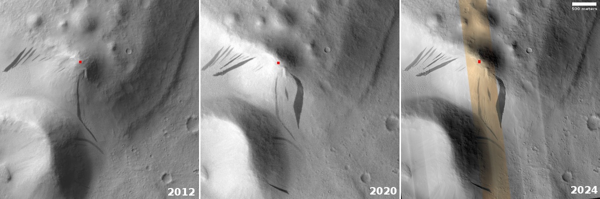
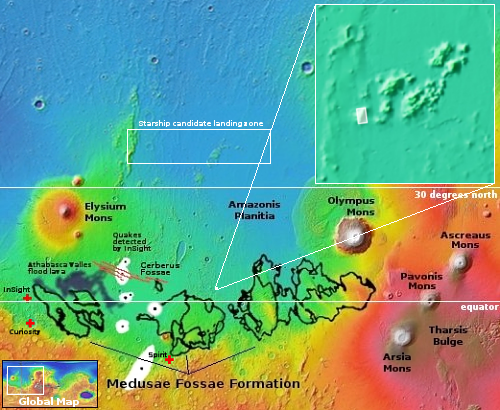
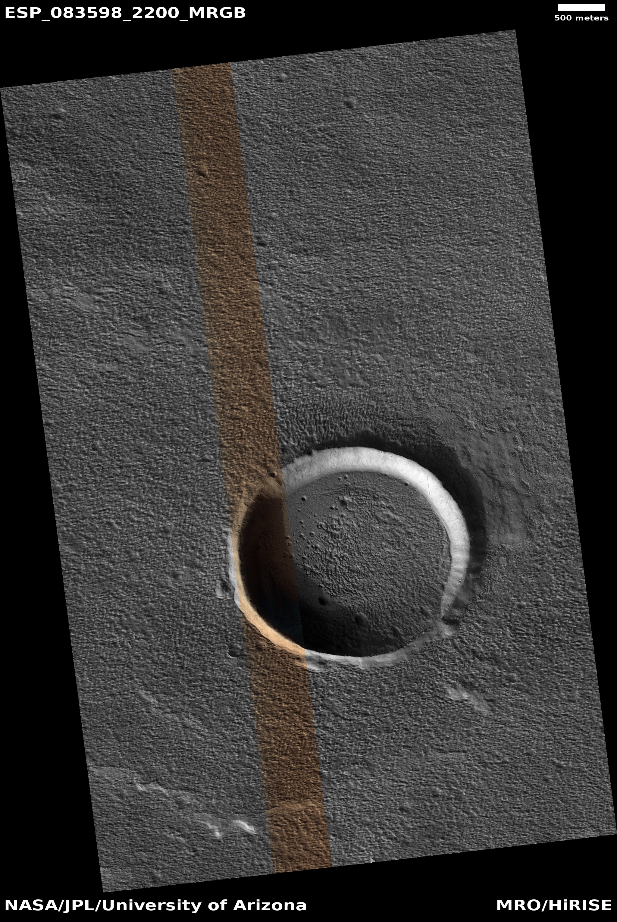
A third sample return mission might also be flown, by SpaceX using its Starship spaceship and Superheavy rocket. Both are built with Mars missions specifically in mind. SpaceX has also ready done work locating a preliminary landing zone. If so, it could possible attempt this mission at about the same time, independent of both China or NASA.

Or it might simply offer Starship as part of the redesigned NASA sample return mission. There is also the chance SpaceX would do both.

If I had to bet, I would say SpaceX (on its own) is the most likely to do this first, with China second. If SpaceX teams up with NASA then it will be a close race between NASA and China.

1 comment

A channel of ice, water, or lava?

A channel of ice, water, or lava?
Click for original image.

Cool image time! The picture to the right, rotated, cropped, reduced, and sharpened to post here, was taken on July 16, 2024 by the high resolution camera on Mars Reconnaissance Orbiter (MRO). It shows one small section of a Martian canyon approximate 750 miles long and dubbed Elysium Fossae.

The canyon walls at this spot rise about 3,300 to 3,800 feet from the canyon floor. The canyon itself is thought to be what geologists call a graben, initially formed when the ground was pulled apart to form a large fissure.

That’s what happened at this location, at least to start. This canyon is on the lower western flank of the giant shield volcano Elysium Mons. The cracks, which radiate out outward from the volcano’s caldera, likely formed when pressure from magma below pushed upward, splitting the surface.

That formation process however does not fully explain everything.
» Read more

0 comments

A frozen Martian splash

A frozen Martian splash
Click for original image.

Cool image time! The picture to the right, rotated, cropped, and enhanced to post here, was taken on July 11, 2024 by the high resolution camera on Mars Reconnaissance Orbiter (MRO). It shows the southeast quadrant of a three-mile-wide unnamed crater that is surrounded on all sides by a dramatic but frozen splash apron of material, created when this impact occurred.

The rim rises between 200 to 400 feet from the surrounding plains, while the crater floor drops 700 feet to sit below those plains by 300 to 500 feet. In other words, that splash apron contains the material that was thrown up when the bolide drilled into the plain at impact, leaving behind this deep hole.

Why such a dramatic splash apron? Its existence suggests that the ground here was muddy, with a lot of water ice likely present. The location and wider context helps confirm this guess.
» Read more

0 comments

A cliff of ice on Mars

A cliff of ice on Mars
Click for original image.

Cool image time! The picture to the right, cropped to post here, was taken on April 10, 2024 by the high resolution camera on Mars Reconnaissance Orbiter (MRO). It shows the southern nose of a large plateau located in the deep south of Mars, at 63 degrees south latitude. This cliff is only about 20-25 feet high, but within that small distance orbital imagery as revealed what appears to be an underground layer of ice. When this photo was released in late June, it came with a short caption, which noted:

On these steep scarps, ice can still be seen on the south facing walls of the scarp towards the end of the Southern Hemisphereโ€™s winter.

Note the white sections on that cliff wall, both inside and outside the color strip. The surrounding orange suggests dust and sand. This photo suggests that during the dark winter underground ice leaches out on these slopes, and is then sublimated away when the Sun returns in the spring. Since the south-facing walls remain in shadow the longest, the ice there lasts the longest, leaving behind these patches we see now.

It is also possible that this is not water ice and there is no underground ice layer. Instead, this might be the last leftover of the dry ice mantle that falls as snow and covers all of the Martian high latitudes during the winter, and then sublimates away come spring.
» Read more

0 comments

First New Glenn launch, set for October 13, 2024, only has an 8-day launch window

According to an article from Aviation Week today, in order for Blue Origin’s New Glenn rocket to get its payload of two Mars orbiters on their way to Mars it must launch within a very short window lasting only eight days, beginning on the present launch date of October 13, 2024.

The Oct. 13-21 launch window is an ambitious goal. The aft and mid modules of New Glennโ€™s reusable first stage were recently attached, clearing the path for installation of the vehicleโ€™s seven methane-fueled BE-4 engines, CEO Dave Limp noted in an Aug. 23 update on the X social media site.

A static hot-fire at New Glennโ€™s Florida launch complex is planned prior to launch. The company did not release the status of the New Glenn upper stage, which is to be powered by a pair of BE-3U engines fueled by liquid oxygen and liquid hydrogen. A hot-fire of the second stage is also pending.

This launch will be the first ever for New Glenn. To get ready for that tight launch window it appears a great deal of work must be done in the next six weeks, some of which Blue Origin engineers will be doing for the very first time.

If there are any issues and that launch window is missed, the two NASA Escapade orbiters, built by Rocket Lab, will face a two-year delay until the next window to get to Mars re-opens. At that point New Glenn will likely do this launch with a dummy payload, since it needs to get off the ground in order to fulfill other launch contracts, including a 27-launch contract with Amazon for its Kuiper satellite constellation.

2 comments

Changing Martian slope streaks

Changing slope streaks on Mars
Click here, here, and here for original images.

Overview map

Time for some cool images from Mars taken over a dozen years! The three pictures above were taken, from left to right, in 2012, 2020, and 2024 and show the same exact Martian terrain. The first two pictures were photographed by the lower resolution context camera on Mars Reconnaissance Orbiter (MRO). The rightmost picture was taken on May 20, 2024 by MRO’s high resolution camera.

The white dot on the overview map to the right marks the location, in the middle of the vast lava flood plains found between Mars’ giant volcanos and north of the Medusae Fossae Formation, the largest volcanic ash deposit on Mars. The 1,200-foot-high mesa pictured above, its peak indicated by the red dot, is part of a group of such mesas that either represent the peaks of a mountain range now mostly buried by lava, or volcanic vents pushed up when those eruptions were occurring more than a billion years ago.

The focus of these pictures however is not volcanism, but the numerous slope streaks seen on the mesa slopes. Note how the 2012 earliest streaks are still visible in 2024, but have faded. Note also how there appears to have been no new streaks since 2020.

Slope streaks are a geological feature unique to Mars that at the moment remain unexplained. At first glance they appear to be a landslide of some kind, but years of orbital study has shown they do not change the topography at all, they never have debris piles at their base, and the streaks even sometimes actually flow up and over small rises in the slopes. They occur randomly throughout the year, and as seen above, over time fade.

Recent research has suggested their formation is related to dust avalanches triggered by dust storms, conclusions that are strengthened by the fact that slope streaks are generally found on dusty slopes, which in this case makes sense as the location is in the dry Martian tropics. That these dust avalanches do not change the topography at all, merely staining it, while sometimes actually flowing up and over rises, illustrates how Mars’ one-third gravity and thin, cold atmosphere makes things happen that are impossible on Earth.

1 comment

Evidence of Martian near-surface ice in an unusual location

Evidence of Martian near-surface ice in an unusual location
Click for original image.

Cool image time! The picture to the right, cropped, reduced, and sharpened to post here, was taken on May 27, 2024 by the high resolution camera on Mars Reconnaissance Orbiter (MRO). Labeled merely as a terrain sample, it was likely taken not as part of any specific research request, but to fill a gap in the camera’s picture-taking schedule so as to maintain its proper temperature.

The picture however shows features that help confirm earlier research into the near-surface ice believed to permeate Mars’ middle latitudes. The knobby flat terrain both inside and outside of the crater resembles what scientists have labeled “brain terrain”, an as-yet unexplained geological feature unique to Mars and usually associated with near-surface ice and the glacial features found above 30 degrees latitude.

This 1.4-mile-wide unnamed crater is located at 40 degrees north latitude, so expecting near-surface ice or glacial features here is not unreasonable. The location however is different for other reasons, that make this data more intriguing.
» Read more

0 comments
1 12 13 14 15 16 128