How cats conquered the world

Link here. This first large scale study of the DNA of ancient cat remains tracks how felines initially spread through human society in the ancient world.

The article and the researchers appear to make one mistake, however, in questioning whether cats have been domesticated. Anyone who owns a cat can answer that question unequivocally: No! Cats merely agree to live with us, on the condition that we treat them as they demand.

Saturn’s wonderful rings

Saturn's rings, and the small moons that shape them

Cool image time! The image on the right, reduced to fit here, is a recent Cassini image, taken July 2, 2016, that shows the rings as well as the moon Pan nestled within the ring’s narrow gap

Pan (17 miles or 28 kilometers across, left of center) holds open the Encke gap and shapes the ever-changing ringlets within the gap (some of which can be seen here). In addition to raising waves in the A and B rings, other moons help shape the F ring, the outer edge of the A ring and open the Keeler gap. This view looks toward the sunlit side of the rings from about 8 degrees above the ring plane. The image was taken in visible light with the Cassini spacecraft narrow-angle camera on July 2, 2016.

The image also highlights the incredible and quite magical beauty of Saturn’s rings, which remain to me one of the solar system’s most amazing wonders.

Scientists make guess about origins of Pluto’s nitrogen sea

Garbage in, garbage out: Scientists have written a computer model that supposedly tells them how Pluto’s thick heart-shaped glacier packed ocean of nitrogen and carbon monoxide formed.

[T]o find out how the glaciers formed in the first place, scientists created models that simulated atmospheric circulation on the dwarf planet for the last 50,000 years (a mere 200 orbits around the sun for Pluto). At the beginning of the simulations, the researchers gave Pluto a planet-wide veneer of nitrogen, carbon monoxide, and methane ices a few millimeters thick; then, the planet’s surface and atmosphere evolved as the icy orb passed through orbit after orbit. If Pluto were a completely smooth sphere, it would have either a permanent swath of nitrogen ice at the equator or seasonal snow caps at its poles. But that’s not what the planet looks like today. When researchers added realistic topography to the model, including the 4-kilometer-deep Sputnik Planum and two other large craters, the basin gradually trapped Pluto’s nitrogen, carbon monoxide, and much of its methane, the researchers report online today in Nature.

While the computer model here can help planetary scientists better understand how Pluto might have evolved, to use it to draw any conclusions about Pluto’s geological history is absurd. Scientist have no idea what Pluto was like 50,000 years ago. Heck, we don’t even know what half the planet looks like now.

Suspicious climate data manipulation at NASA

The uncertainty of modern climate science isn’t merely because of the overall complexity of the data and the climate. Though there are numerous factors that contribute to the long term fluctuations of the climate that we do not yet completely understand or can quantify with any precision (the sun, dust, soot, volcanoes, carbon dioxide increase, to name just a few), there is a more tragic uncertainty that global warming scientists at NASA and NOAA have added to the mix, one that is entirely unjustified and harmful to the field of science and the questions that it is trying to answer.

In the case of this post, that tragic uncertainty has to do with sea level rise and the “adjustments,” without explanation, that NASA is making to its sea level data. Below is a graph taken from the link, showing the changes that have been made to published data from 1982 in order to eliminate a long period of almost no sea level rise from the mid 1950s through 1980.
» Read more

Thirty ton meteorite excavated in Argentina

In what is one of the largest asteroid chunks ever found on Earth, an excavation team from a local astronomy club this week excavated a thirty ton iron-nickel meteorite from the ground.

Dubbed Gancedo after a nearby town, it isn’t a record-holder, but it sure is big. What I found interesting from the article, however, is this:

Gancedo’s fall to Earth occurred between 4,000 and 6,000 years ago. Locals knew of the fall for centuries, even making iron tools from meteorites found in the strewnfield. In the 16th century, the Spanish became interested in stories of a piece of iron that fell from the sky, and in 1774 don Bartolomé Francsico de Maguna led an expedition that came across a mass of iron, referred to as Mesón de Fierro (“Table of Iron” in Spanish). Another 1,400-pound fragment from Campo del Cielo named Otumpa now resides at the British Museum in London. With more than 100 tons of meteorite recovered, Campo del Cielo is the top producer in terms of pure meteorite mass worldwide.

The Campo del Cielo strewnfield extends over an ellipse 3 km wide by 19 km long over an area northwest of Buenos Aires, and meteorites found here have a polycrystalline coarse octahedrite composition characteristic of iron-nickel meteorites. They are also unusually pure even among iron-nickel meteorites, consisting of 93% iron. Most of the remaining 7% is nickel, and less than 1% are trace elements.

The evidence here is that a very dense asteroid, weighing a minimum of 100 tons but probably several times that, smashed into the Earth about five thousand years ago. Yet, all life on Earth was not wiped out, as is repeatedly suggested might happen whenever a similarly sized asteroid zips close past the Earth. In fact, there is no evidence this impact had any significant global environmental effects.

Remember this the next time another asteroid of similar size zips past the Earth and the media doom-sayers begin to sing their siren song again.

UN Secretary-General declares climate change debate ‘over’

The certainty of politics: In a newspaper interview on Thursday UN Secretary-General Ban Ki-moon declared, without doubt, that the scientific debate on human-caused global warming “is over”.

U.N. Secretary-General Ban Ki-moon said Thursday that his greatest achievement at the helm of the world’s biggest international organization was last year’s climate change accord in Paris, and he expressed open frustration that Republicans in the U.S. continue to obstruct President Obama and to politicize the subject. “The debate on science and the debate on politics as far as climate change is concerned is over,” Mr. Ban told The Washington Times in an exclusive interview. “Still, the Republican Party, they are not convinced.

“There should be no political consideration on this,” he said. “There should be no room for politics to get involved.” [emphasis mine]

I am so glad that this politician, not a scientist, knows so much about the climate field that he can dictate the future research of scientists. I am so glad that this politician, not a scientist, thinks he has the ability to tell skeptics to shut up. And I am so glad that this politician, not a scientist, can demand that skeptics shut up because he wants to keep politics out of science. (Note the irony and hypocrisy here.)

I find it most interesting that whenever anyone raises questions about the theory of human-caused global warming, the response by its advocates is almost never to discuss the actual data, but to tell the questioners to shut up, and to insist the debate is settled, even though the very existence of those questioners proves it is not.

Rosetta’s last days

The Rosetta team has released a detailed description of what will be happening in the last two weeks of the spacecraft’s mission, leading up to its landing on the comet’s surface on September 30.

Their description of the difficulty of planning maneuvers based on the complex asymmetrical gravitational field of the two-lobed comet nucleus is especially interesting.

Saturn in all its glory

Saturn

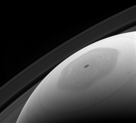
Cool image time. The Cassini science team have released a beautiful full-color image of Saturn, shown cropped on the right, as well as a movie, both produced from images taken in April.

This view shows Saturn’s northern hemisphere in 2016, as that part of the planet nears its northern hemisphere summer solstice in May 2017. Saturn’s year is nearly 30 Earth years long, and during its long time there, Cassini has observed winter and spring in the north, and summer and fall in the south. The spacecraft will complete its mission just after northern summer solstice, having observed long-term changes in the planet’s winds, temperatures, clouds and chemistry.

Cassini scanned across the planet and its rings on April 25, 2016, capturing three sets of red, green and blue images to cover this entire scene showing the planet and the main rings. The images were obtained using Cassini’s wide-angle camera at a distance of approximately 1.9 million miles (3 million kilometers) from Saturn and at an elevation of about 30 degrees above the ring plane. The view looks toward the sunlit side of the rings from a sun-Saturn-spacecraft angle, or phase angle, of 55 degrees. Image scale on Saturn is about 111 miles (178 kilometers) per pixel.

The exposures used to make this mosaic were obtained just prior to the beginning of a 44-hour movie sequence.

The only real tragedy here is that the Cassini mission is ending soon. When it does, it will be decades, at a minimum, before we have another spacecraft in orbit around Saturn and capable of giving us this view.

Update: NASA today issued a press release detailing what will happen during Cassini’s final year at Saturn, including 22 plunges between Saturn and its rings!

New evidence of lakes and streams in Mars’ recent past

Using data from three different orbiters scientists have mapped out a region of lakes and streams on Mars that appear to have contained liquid water a billion years after the red planet is believed to have dried up.

To bracket the time period when the fresh shallow valleys in Arabia Terra formed, scientists started with age estimates for 22 impact craters in the area. They assessed whether or not the valleys carved into the blankets of surrounding debris ejected from the craters, as an indicator of whether the valleys are older or younger than the craters. They concluded that this fairly wet period on Mars likely occurred between two and three billion years ago, long after it is generally thought that most of Mars’ original atmosphere had been lost and most of the remaining water on the planet had frozen.

The characteristics of the valleys support the interpretation that the climate was cold: “The rate at which water flowed through these valleys is consistent with runoff from melting snow,” Wilson said, “These weren’t rushing rivers. They have simple drainage patterns and did not form deep or complex systems like the ancient valley networks from early Mars.”

This region, Arabia Terra, is the same area where scientists have found fossilized rivers.

Hubble captures on-going comet break-up

animation of comet debris

Cool image time! The animation to the right, taken over three days by the Hubble Space Telescope, cropped and reduced to fit here, shows the debris flying away from Comet 332P/Ikeya-Murakami. It also shows a new piece of debris close to the comet on the lower left.

The research team calculated that the comet probably shed material over several months, between October and December 2015. Jewitt suggests that even some of the ejected pieces have themselves fallen to bits in a kind of cascading fragmentation. “Our analysis shows that the smaller fragments are not as abundant as one might expect based on the number of bigger chunks,” he said. “This is suggestive that they’re being depleted even in the few months since they were launched from the primary body. We think these little guys have a short lifetime.”

Hubble’s sharp vision also spied a chunk of material close to the comet, which may be the first salvo of another outburst. The remnant from still another flare-up, which may have occurred in 2012, is also visible. The fragment may be as large as Comet 332P, suggesting the comet split in two. But the icy remnant wasn’t spotted until Dec. 31, 2015, by the Pan-STARRS (Panoramic Survey Telescope and Rapid Response System) telescope in Hawaii, in work supported by the Near-Earth Object Observations program in NASA’s Planetary Defense Coordination Office. That discovery prompted Jewitt and colleagues to request Hubble time to look at the comet in detail. Around the same time, astronomers around the world began to notice a cloudy patch of material near the comet – which Hubble later resolved into the 25 pieces.

The scientists think they actually “may be seeing a comet fragmenting itself into oblivion.”

Four different research papers this year find no evidence linking human activity to sea level rise

The uncertainty of science: Despite the claims that human-caused global warming is causing the icecaps to melt and the sea to rise, four different research papers this year have found no “observable” evidence linking human activity to sea level rise.

“It is widely assumed that sea levels have been rising in recent decades largely in response to anthropogenic global warming,” Kenneth Richard writes at NoTricksZone. “However, due to the inherently large contribution of natural oscillatory influences on sea level fluctuations, this assumption lacks substantiation…. Scientists who have recently attempted to detect an anthropogenic signal in regional sea level rise trends have had to admit that there is ‘no observable sea-level effect of anthropogenic global warming’,” Richard points out, listing four peer-reviewed studies published this year that have all come to the same conclusion.

Does this prove that the rise in sea levels is not influenced by human activity (or “an anthropogenic signal” to use the jargon of these scientists)? Absolutely not. What it does show is that the science of climate change remains completely uncertain, and that it is very possible that all of the sea level rise we see has nothing to do with human activity, something that many climate scientists have recognized for decades. We are still coming out of the last ice age, and these scientists recognize that much if not all of the sea level rise we see can be attributable to this fact.

Charon’s red polar region explained?

Scientists, using data from New Horizons as well as new computer models, think they have come up with an explanation for the red polar region of Pluto’s moon Charon.

As they detail this week in the international scientific journal Nature, Charon’s polar coloring comes from Pluto itself – as methane gas that escapes from Pluto’s atmosphere and becomes “trapped” by the moon’s gravity and freezes to the cold, icy surface at Charon’s pole. This is followed by chemical processing by ultraviolet light from the sun that transforms the methane into heavier hydrocarbons and eventually into reddish organic materials called tholins.

A Mars Rover Update

I have decided to continue my Mars rover updates, and make them a regular mid-week feature here on Behind the Black. This is the first.

Curiosity

For the overall context of Curiosity’s travels, see this post, Pinpointing Curiosity’s location in Gale Crater.

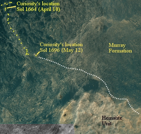
Since my last updates here and here, Curiosity has moved south through the gap between buttes to exit the Murray Butte area. The initial slopes of Mount Sharp lie ahead, an open road with no apparent rough terrain to slow travel.

Doing science however does slow travel, and for good reason. Once through the gap the science team decided to swung the rover west and up against the base of the gap’s western butte, rather than immediately head south to climb the mountain. The Mars Reconnaissance Orbiter image below, cropped and reduced, illustrates this path.
» Read more

Statistical analysis suggests Moon can cause quakes

The uncertainty of science: A careful statistical analysis of when major earthquakes occur has suggested they are more likely to be more powerful if they occur around the full and new moons when tidal forces are at their peak.

Satoshi Ide, a seismologist at the University of Tokyo, and his colleagues investigated three separate earthquake records covering Japan, California and the entire globe. For the 15 days leading up to each quake, the scientists assigned a number representing the relative tidal stress on that day, with 15 representing the highest. They found that large quakes such as those that hit Chile and Tohoku-Oki occurred near the time of maximum tidal strain — or during new and full moons when the Sun, Moon and Earth align.

For more than 10,000 earthquakes of around magnitude 5.5, the researchers found, an earthquake that began during a time of high tidal stress was more likely to grow to magnitude 8 or above.

As these results are based entirely on statistical evidence, not on any direct link between tidal forces and actual quakes, they are quite uncertain and unproven.

Rosetta’s final descent to Comet 67P/C-G

The Rosetta science team today posted two stories, describing details about the planned final descent of the spacecraft to the surface of Comet 67P/C-G on September 30, ending the mission.

The spacecraft will land in a region dubbed Ma’at that contains several active pits more than 300 feet across and 150 feet deep. This is also where several of the comets dust jets originate.

The technology of Star Trek

On this, the fiftieth anniversary of the first airing of the first Star Trek episode, here is a fascinating look at the fictional technology of the series.

I remember that Thursday evening fifty years ago very well. As a teenager I had been suffering for years watching very bad and stupid television science fiction, like Lost in Space, written as if its audiences were five year old children and thus insulting them. Still, as an avid reader of science fiction that knew the genre was sophisticated and intelligent, I held onto the hope that some new science fiction show might finally do something akin to this.

Star Trek did this and more. That first episode had all the best elements of good drama and great science fiction: a mystery, an alien, a tragic figure, and an ancient lost civilization. From that moment until the series was cancelled, I would be glued to my television set when it aired.

You can watch that first episode if you wish, though with commercials. Click on the first link above to do so. In watching it recently when Diane and I decided to rent the original series from Netflix and watch them again, I was surprised how well this episode, as well as the entire first series, has stood up over time. It is not dated. Its drama remains as good. And you know, the writing is sometimes quite stellar, to coin a phrase.

Big money for California air pollution researchers

The next time anyone tries to point out how “Big Oil” or “Big corporations” are using their financial clout to squelch research into air pollution, the environment, and global warming, refer them to this story:

Nineteen California professors earning more than $300 million in grants from the government to study air pollution have issued a letter demanding more air quality regulations, which they can then use as a foundation for earning more government grants studying air pollution.

The environmental movement likes to talk about how big corporate money pays for all the environmental skepticism we see in the press, and if that money disappeared the debate would vanish and everyone would agree with them. The trouble is that most skeptics I know, including myself, get nothing from big corporate money. Instead, it is the environmental movement that gets gigantic amounts of cash from the federal government, run by politicians like President Obama, who has a very pro-environmentalist bias and wants his scientists to confirm his religious belief in human-caused global warming and the evils that humans do to the environment.

Sunspots: A recovery in August

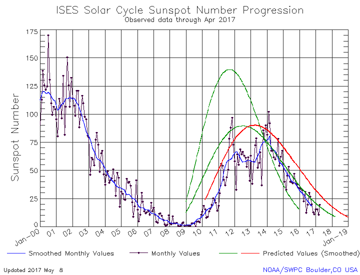
NOAA’s monthly update of the solar cycle was posted today. As I do every month, I am posting it here, with annotations to give it context.

August 2016 Solar Cycle graph

The graph above has been modified to show the predictions of the solar science community. The green curves show the community’s two original predictions from April 2007, with half the scientists predicting a very strong maximum and half predicting a weak one. The red curve is their revised May 2009 prediction.

The recovery in sunspot activity that began in July continued in August. The number of sunspots increased enough to once again raise the overall curve up to match the green curve of the 2007 weak prediction. Even so, this solar maximum remains far weaker than the weakest prediction. Also, this solar maximum, which started later than all the predictions, looks like it will be far shorter than all the predictions. As I have noted previously, this is counter to all previous solar cycles, where it is the more active cycles that are shorter and the weaker cycles are longer. Here, we are getting a weak cycle that is also short, which once again suggests that we are seeing solar behavior previously unobserved. The solar cycle is doing things it hasn’t done since scientists began studying it closely after Galileo.

Philae found!

Philae!

Less than a month before Rosetta’s mission ends the spacecraft’s high resolution camera has finally located Philae in its final resting spot on the surface of Comet 67P/C-G.

The images were taken on 2 September by the OSIRIS narrow-angle camera as the orbiter came within 2.7 km of the surface and clearly show the main body of the lander, along with two of its three legs. The images also provide proof of Philae’s orientation, making it clear why establishing communications was so difficult following its landing on 12 November 2014.

The image on the right clearly shows the lander on its side with one leg sticking up, as theorized by the Rosetta engineers based on the small amount of data they had received before Philae went dead. Furthermore, the wide image at the link above shows that the lander landed exactly as predicted by data, up against a wall — in this case a large boulder — which placed it in shadow most of the time.

Opportunity’s future travels on Mars

Opportunity's future path

Approaching the gap

Having spent a lot of time recently analyzing the travels of Curiosity in Gale Crater and in the foothills to Mount Sharp, I decided this week that I also needed to do the same with Opportunity at Endeavour Crater.

The image above is a panorama that I have assembled from images taken by Opportunity’s navigation camera on Sol 4477 (sometime last week). To the right is a panorama assembled from images taken by the navigation camera several days later, on Sol 4481, after Opportunity had moved closer to the gap shown in the first picture above. The inset in the image above shows the location of the image on the right. The X shows Opportunity’s approximate position.

Below the fold is the most recent orbital mosiac showing Opportunity’s recent travels near Endearvour Crater and in Marathon Valley, cropped and annotated by me to indicate the areas seen by the two panoramas above. The red dot shows Opportunity’s present position.
» Read more

First science results from Juno

Storms at Jupiter's pole

The Juno science team today released the mission’s first science results gathered during its first close fly-by of Jupiter.

I have cropped on the right one of their full images to focus in on two of the strangely shaped storms Juno imaged during its pass. This image is of the northern pole. They also have some fascinating images of the south pole storms as well. Unlike the equatorial regions, which on gas giants have what appear to be parallel coherent bands of weather, the poles appear very chaotic, with the storms forming shapes that have not been seen in any other atmosphere in the solar system. They also found a hexagon-shaped weather feature in the pole.

The first link above also included data from the spacecraft’s other instruments, showing the gas giant’s complex atmosphere in a variety of other wavelengths.

NASA sets InSight’s new launch date to Mars

NASA has now set 2018 as the new launch date for its Mars InSight mission.

The mission was originally supposed to launch in 2016, but missed that launch window when significant problems cropped up during construction of the spacecraft’s French-built prime instrument. NASA has now taken much of the responsibility for building that instrument away from the French and given it to JPL.

The SEIS instrument — designed to measure ground movements as small as half the radius of a hydrogen atom — requires a perfect vacuum seal around its three main sensors in order to withstand harsh conditions on the Red Planet. Under what’s known as the mission “replan,” NASA’s Jet Propulsion Laboratory in Pasadena, California, will be responsible for redesigning, developing and qualifying the instrument’s evacuated container and the electrical feedthroughs that failed previously. France’s space agency, the Centre National d’Études Spatiales (CNES), will focus on developing and delivering the key sensors for SEIS, integration of the sensors into the container, and the final integration of the instrument onto the spacecraft.

The cost for the changes and reschedule is estimated to be more than $150 million, adding to the budget strain in NASA’s science programs already caused by the overruns from the James Webb Space Telescope.

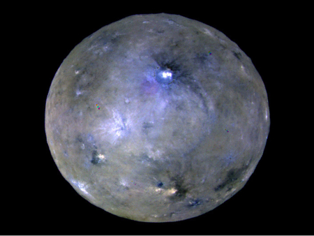
The surface of Ceres lacks water

The uncertainty of science: Despite significant evidence that water ice has helped form specific features on Ceres, other data collected by Dawn suggest that there is not much ice on the surface.

Angular polygonal craters on the surface suggest that Ceres’ crust is fractured, furthering the conclusion that the near-surface crust “must be both brittle enough to fracture and strong enough to retain fractures for long periods of time.”

“Based on our analysis, the crust of Ceres is too strong to be dominated by ice,” said Debra Buczkowski of the Johns Hopkins Applied Physics Laboratory in Laurel, Maryland, the study’s lead author. “While surface features such as the lobate flows show that water ice is present in the dwarf planet’s upper crust and on the surface in some locations, it appears not to be a major factor in creating surface features.”

In addition to studying the surface, researchers drew conclusions about the dwarf planet’s interior makeup. Beneath a strong crust composed of rock, ice and salt hydrates lays a water-rich mantle and a silicate core. Evidence of cryomagmatism is found in the floor-fractured craters, while Ahuna Mons and other domical features have been shown to be cryovolcanic in nature. These surface features suggest that Ceres has been geologically active at some point in its past, perhaps even its recent past.

Note that in just two days, Dawn researchers released two press releases, the first noting that water ice played a significant role in molding major features on Ceres, and the second noting that the surface doesn’t have much water ice. How’s that for a nice demonstration of the uncertainty of science?

Ahuna Mons, Ceres’s biggest mountain, is an ice volcano

Ahuna Mons

Using data from Dawn scientists have concluded that Ceres’s biggest mountain, Ahuna Mons (shown on the right), was created by water volcanism.

“Ahuna is the one true ‘mountain’ on Ceres,” said David A. Williams, associate research professor in Arizona State University’s School of Earth and Space Exploration. “After studying it closely, we interpret it as a dome raised by cryovolcanism.” This is a form of low-temperature volcanic activity, where molten ice — water, usually mixed with salts or ammonia — replaces the molten silicate rock erupted by terrestrial volcanoes. Giant mountain Ahuna is a volcanic dome built from repeated eruptions of freezing salty water.

The implications of this fact are important, as it suggests that Ceres’s interior was warm enough for long periods, enough to melt ice. Where that heat came from however is a mystery, considering the dwarf planet’s small size.

1 152 153 154 155 156 280