
New long term analysis of solar activity suggests the Sun is undergoing some form of internal structural change
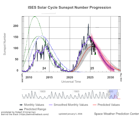
NOAA’s chart of sunspot activity.
Click for the most recent update.
The uncertainty of science: Scientists doing a new analysis of more than forty years of solar data have concluded that some form of “subsurface structural changes associated with successive 11-year [sunspot] cycles” are taking place, with those changes “ever more progressively confined just beneath the solar surface.”
Using almost 40 years of helioseismic data from six telescopes around the world in the Birmingham Solar Oscillations Network (BiSON), the researchers uncovered a gradual change in structure just beneath the surface that has spanned multiple cycles, with the current solar cycle 25 showing particularly strong signatures of these changes.
Lead author Professor Bill Chaplin, from the University of Birmingham, said: “The Sun has its own ‘active biorhythm’ creating rising and falling magnetic activity that shapes space weather. However, traditional surface measures don’t capture the full story – that the Sun may be entering a different mode of behaviour unfolding over decades.
“We have uncovered evidence of systematic changes in the solar activity cycle. Crucially, magnetic activity is becoming more tightly confined near the surface with each cycle.”
The confinement appears to be within the first 600 miles below the surface, which for the Sun is barely skin deep.
In reading the paper [pdf], it is very clear they have detected these changes, but are as yet unable to apply them to any larger fundamental processes. They are observing the Sun change, but don’t know why. It could be simply random fluctuations of behavior, or it could be part of the Sun’s normal behavior related to its magnetic field and the nuclear fusion that makes it burn.
In either case, this lack of deeper understanding means it is impossible as yet to predict what will happen next, or how those future changes will impact us here on Earth.


.jpg)