Polygons on Mars
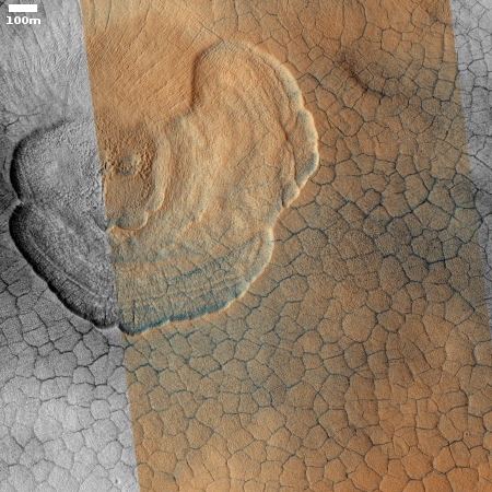
Cool image time! The photograph on the right, cropped to post here, was taken on September 25, 2019 by the high resolution camera on Mars Reconnaissance Orbiter (MRO) and made public in its November image release. It shows the weird but very typical scalloped terrain, with its adjacent polygon pattern of fractures, found routinely in the northern lowland plains of Utopia Planitia on Mars. From an earlier captioned image from 2006 of these same features:
The scalloped depressions are typical features; a smooth layered terrain located between 40 and 60 degrees in both hemispheres. Scalloped depressions probably form by removal of ice-rich subsurface material by sublimation (ice transforming directly from a solid to a gaseous state), a process that may still be active today. Isolated scalloped depressions generally have a steep pole-facing scarp and a gentler equator-facing slope. This asymmetry is interpreted as being the result of difference in solar heating. Scalloped depressions may coalesce, leading to the formation of large areas of pitted terrain.
The polygonal pattern of fractures resembles permafrost polygons that form in terrestrial polar and high alpine regions by seasonal-to-annual contraction of the permafrost (permanently frozen ground). On Earth, such polygons indicate the presence of ground ice.
On Earth these polygons are most often seen in mud, usually suggesting a drying process where the ground contracts with the lose of fluid. On Mars the cracks probably also form from contraction, but not by the lose of fluid but the lose of water ice as it sublimates into a gas.
These polygons and scallops illustrate an important feature of Mars’ vast northern plains. On large scales these plains appear flat and featureless. Up close however many many strange features, like the polygons and scallops in this image, come into view.
» Read more

