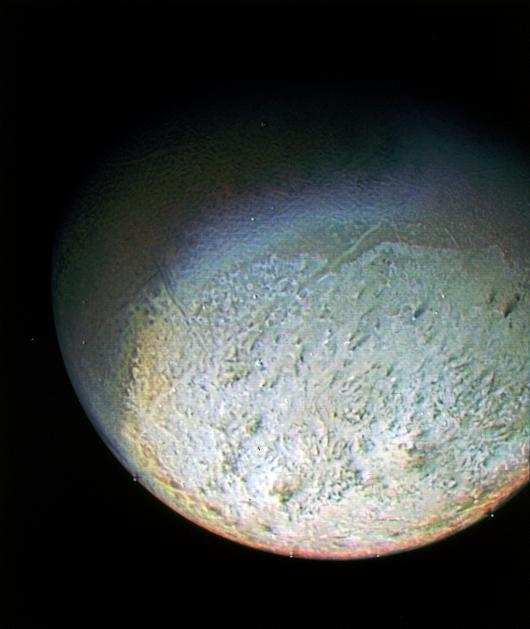
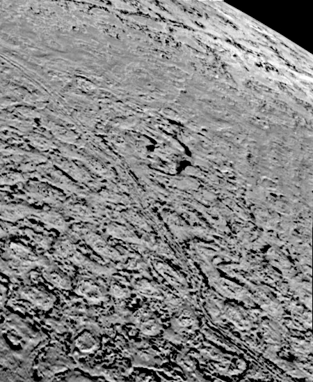
Voyager-2’s most detailed look at Neptune’s moon Triton
Click for original image.
Today we conclude our tour of the Voyager-2 fly-bys of Uranus in 1986 and Neptune in 1989 with what is the most detailed look at the alien surface of Neptune’s moon Triton, taken on August 25, 1989 and shown to the right, cropped, rotated, reduced, and sharpened to post here.
Taken from a distance of only 25,000 miles, the frame is about 140 miles across and shows details as small as [a half mile in width]. Most of the area is covered by a peculiar landscape of roughly circular depressions separated by rugged ridges. This type of terrain, which covers large tracts of Triton’s northern hemisphere, is unlike anything seen elsewhere in the solar system. The depressions are probably not impact craters: They are too similar in size and too regularly spaced. Their origin is still unknown, but may involve local melting and collapse of the icy surface.
A conspicuous set of grooves and ridges cuts across the landscape, indicating fracturing and deformation of Triton’s surface. The rarity of impact craters suggests a young surface by solar system standards, probably less than a few billion years old.
What this photograph as well as the handful of other Voyager-2 images of Triton tell us is that we only have gotten a tiny taste of what’s there, only enough to tell us we don’t understand what we are seeing in the slightest. This is a truly alien world, cold, dark, and composed of materials far different then that found in the inner solar system. Its formation is a mystery, and its subsequent geological history a cypher. Scientists have made some guesses, but to get a real understanding we need to go back, and be there for a long time.
In fact, this is the final conclusion of all of the Voyager-2 images from both Uranus and Neptune. That probe gave humanity its first good close look at these distant worlds, but the look was still a quick and very superficial one. The images and data left us with far more questions than answers.
Unfortunately, there is at present no mission approved and under development to go to either Uranus or Neptune, though several have been proposed. Thus, it will likely be at least two decades before any mission gets there, if that soon.
Click for original image.
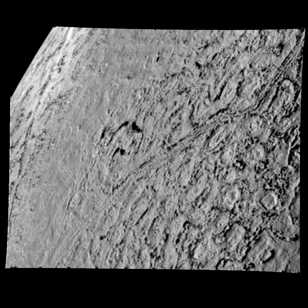
Today we conclude our tour of the Voyager-2 fly-bys of Uranus in 1986 and Neptune in 1989 with what is the most detailed look at the alien surface of Neptune’s moon Triton, taken on August 25, 1989 and shown to the right, cropped, rotated, reduced, and sharpened to post here.
Taken from a distance of only 25,000 miles, the frame is about 140 miles across and shows details as small as [a half mile in width]. Most of the area is covered by a peculiar landscape of roughly circular depressions separated by rugged ridges. This type of terrain, which covers large tracts of Triton’s northern hemisphere, is unlike anything seen elsewhere in the solar system. The depressions are probably not impact craters: They are too similar in size and too regularly spaced. Their origin is still unknown, but may involve local melting and collapse of the icy surface.
A conspicuous set of grooves and ridges cuts across the landscape, indicating fracturing and deformation of Triton’s surface. The rarity of impact craters suggests a young surface by solar system standards, probably less than a few billion years old.
What this photograph as well as the handful of other Voyager-2 images of Triton tell us is that we only have gotten a tiny taste of what’s there, only enough to tell us we don’t understand what we are seeing in the slightest. This is a truly alien world, cold, dark, and composed of materials far different then that found in the inner solar system. Its formation is a mystery, and its subsequent geological history a cypher. Scientists have made some guesses, but to get a real understanding we need to go back, and be there for a long time.
In fact, this is the final conclusion of all of the Voyager-2 images from both Uranus and Neptune. That probe gave humanity its first good close look at these distant worlds, but the look was still a quick and very superficial one. The images and data left us with far more questions than answers.
Unfortunately, there is at present no mission approved and under development to go to either Uranus or Neptune, though several have been proposed. Thus, it will likely be at least two decades before any mission gets there, if that soon.