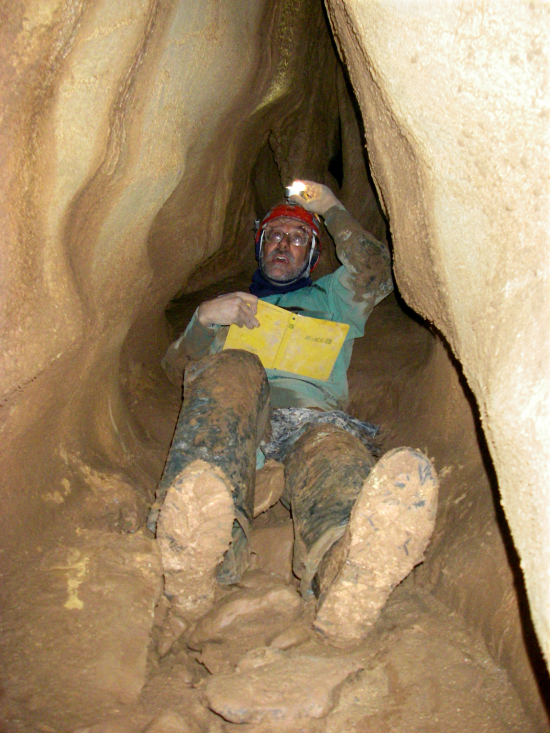
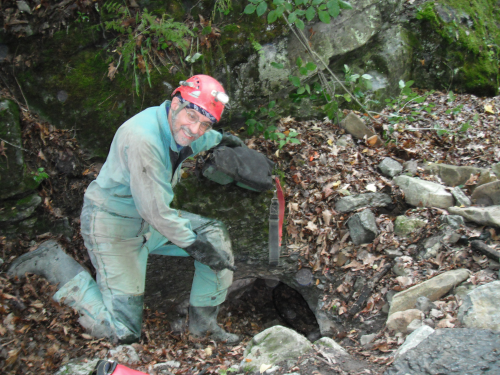
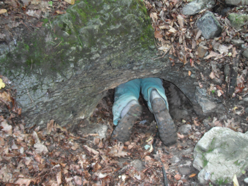
Cave exploration in the western mountains

scree slope
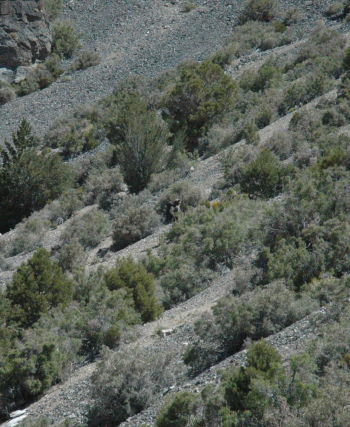
Anthony Smith struggling up a scree mountain slope.

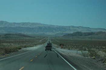
I have only visited Nevada twice before, and those visits had been limited to the area around Las Vegas. Thus, my impression of the state had been similar to what most other people assume: a big ostentatious urban city surrounded by boring flat deserts.

Instead what I found is that Nevada is probably one of the most beautiful states in the nation. It has many mountain ranges, interspersed with wide flat valleys, a number of which have lakes or swampy areas because the water is trapped there, draining neither to the Pacific or Atlantic.

Yet, it is desert country. The limited amount of water means that the state is lightly populated, and the few farms or ranches that you pass actually act to amplify the feeling of emptiness. This is further enhanced by the frequent mountain ranges. Every time you cross over a range, you find yourself high in the air with a spectacular view of the vast valleys below.

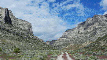
The Forest Service job that I was part of this past week was focused on inventorying and surveying a number of known caves covering a large area in northeastern Nevada. The work had actually started several years earlier, so that this particular week was the final wrap up, mapping the last few known caves on the list while also ridge-walking several different canyons in an effort to find some new discoveries.
» Read more

On the way home

We are right now driving between Las Vegas and Hoover Dam, and should be home late tonight. Thus, I should be able to resume blogging sometime tomorrow. I will also write up a description of my experiences this past week and post it tomorrow.

First day caving in Nevada

It is late and I have to up at 5 am to head to another cave tomorrow, so there is no time to give a detailed update of what happened today

However, here is a quick summary. Our goal was to find and map a rarely visited and difficult to find cave. After four miles of hiking and a lot of wandering across some pretty spectacular mountainsides, we failed to find the cave. However, we did locate two other small caves, which we surveyed, and then, on the way back to the vehicles, discovered a previously unknown cave of some size with significant formations. This was quite exciting, as the cave was clearly virgin, never seen by humans before.

We hope to return to explore and map it later in the week. Once again, I will get to go where no one has ever gone before!

Tomorrow will probably be as long a day as today, so I probably will not be able to post a more detailed report until Saturday. Stay tuned.

Off to Nevada

Nevada

For the next seven days my daytime posting is going to be spotty, as I will be in some remote areas of Nevada working on an on-going Forest Service project to inventory and survey caves in an area in the northeastern area of the state. The project is mostly over, but as I have surveyed, sketched, and done the cartography for many eastern U.S. caves, the guy running the project asked if I would be interested in participating. Interested? I was thrilled.

Though we will be in a somewhat remote area, I still hope to post periodically during the week, not only about the usual topics but also about some of the caves we will have surveyed, some of which are rarely visited. I will also try to post some pictures of the spectacular country we expect to visit. (The photo on the right was provided to me by Tom Gilleland, who is running the project.) Stay tuned.

Underground again today

glass plate

Posting will be light today, as I am joining University of Arizona PhD student Sarah Trube and several other Arizona cavers on a cave trip to collect water samples in a southern Arizona cave. This is in connection with research Sarah is doing to analyze the chemistry of cave dripwater and how it leads to the formation of cave speleothems. Moreover, she is tracking water flow and attempting to link it to climate and weather variations over time.

I noticed Sarah’s water collection equipment on my first Tucson-area cave trip back last January. In one case she had attached a tube to the bottom of a stalactite which fed the dripwater into a bottle. In another case she placed glass plates on top of stalagmites to allow the dripwater to drip onto the plate and then evaporate. Last month I joined her on one of her collection trips, where she gathered glass plates for later analysis in the lab. Though the plates had not been in cave more than a few months, you could easily see a thin layer of calcite deposit on their surface.

Below the fold is an image of Sarah gathering dripwater during an earlier trip.
» Read more

Underground exploring today

No posting today, as I am leaving home at 6:30 am with several cavers for a day trip to a cave in the Chiricahua Mountains in southeast Arizona. The drive one way is about three and a half hours, so doing this as a day trip will likely break what I like to call Zimmerman’s law: “The cave time must exceed the drive time.”

However, when I first visited Tucson last winter and mentioned I might move here, the local cavers asked if I’d be interested in being the cartographer of this particular cave and help them get a project started to survey it. Three previous attempts to survey it were never completed, so no good map exists. And since I have recently completed two significant cave maps of two important West Virginia caves (see monographs 3 and 4 on this page) and am without a map project at the moment, how could I say no? Tomorrow’s trip is my first visit to the cave in preparation for getting the survey project off the ground in January.

Anyway, I will be back late, and will return to the computer on Saturday. For everyone, have a Merry Christmas weekend!

An international team of astronauts recently completed a six day underground cave mission

An international team of astronauts recently completed a six day underground cave mission in an effort to simulate some of the aspects of space exploration on another world.

I, along with my cave exploration friends, find this article somewhat humorous, as these astronauts weren’t doing anything that unusual from our perspective. Routinely we have teams going underground for three to five days to do exploration and survey work as part of the Germany Valley Karst Survey in West Virginia. The result has been more than fifty miles of virgin passage in the past eight years.

But, if these astronauts want to join us and do some exploration, they’d be welcome!

New cave discoveries in the western Caucasus of Russia

From an email sent out by Ukrainian caver Alexander Klimchouk, received today:

Pavel Rud’ko of Krasnoyarsk (Rissia, Siberia) has reported the success of the recent expedition of Krasnoyarsk cavers to the Sarma Cave, Arabika Massif, Western Caucasus. The cave, previously explored by cavers from Krasnoyarsk and Irkutsk to -1570 m, has now been made almost 200 m deeper, to reach depth of -1760m and become the second deepest cave in the world.

The expedition led by Pavel Rud’ko has been carried out between September 1st – October 7th, 2011. The main branch has been pushed to -1760 m after breaking through a narrow meander at the old bottom. Many side and ascending passages in other parts of the cave have been also explored. The expedition performed systematic temperature measurements, and speleobiological and microbiological sampling.

With its new depth figure, Sarma surpassed the Illjuzia-Mezhonnogo-Snezhnaya system (-1753 m), located in the nearby Bzybsky Massif, and became the second deepest cave in the world, following Krubera Cave (-2191 m) located in the same massif. Thus, the western Caucasus now hosts three deepest caves in the worlds, two of them in Arabika Massif and one in Bzybsky Massif.

Some details of geology, hydrogeology and cave locations of Arabika can be found here. [pdf]

Caving in Druid Cave, Cheat Canyon, West Virginia

An evening pause: Caving in Druid Cave, Cheat Canyon, West Virginia. The caver is David Riggs. The videographer is caver Aaron Bird. The caver who arrives at the end with the ATV is caver Brian Masney. All are world class cavers, with whom I’ve had the honor of caving.

The video is nicely done, and gives an excellent and accurate feel for modern cave exploration and techniques. Watch especially how the rigging allows David to climb past the waterfall while on rope and hardly get wet.

Exploring the floor of Copernicus

thumbnail of index of caves on floor of Copernicus

The Lunar Reconnaissance Orbiter website recently announced a new way to tour the Moon. The website, called QuickMap, allows a user with any home computer to zoom into any spot on the lunar surface and see the high resolution images being taken by Lunar Reconnaissance Orbiter.

Using QuickMap, I spent a few hours this past weekend strolling about on the northern half of the floor of the crater Copernicus. It is in this area, annotated in the image on the right, that NASA engineer James Fincannon has already located a slew of collapse features and possible caves, the images of which I have posted previously on behindtheblack. (Click on the image or here to see a larger version of this updated index map.)

(You also can go sightseeing there if you wish. Go to QuickMap and zoom in on 10.1 latitude and -20.1 longitude to get to the floor of Copernicus. Or pick your own spot on the lunar surface and do some of your own exploring!)

What I found in the northern half of Copernicus’s floor was a plethora of possible caves and collapse features. Literally, the crater floor is littered with what appear to be pits, fissures, rills, and sinks. More significantly, sometimes the cave entrances line up with long straight collapse features, suggesting strongly the existence of extensive underground passages beyond the initial entrance pits.
» Read more

White nose found in North Caroina

The fungus that has been killing cave hibernating bats throughout the eastern United States has now been found in North Carolina.

In a related note, the National Speleological Society has sent a letter to the U.S. Fish and Wildlife Service, expressing its concern over what many cavers believe has been the government’s indiscriminate cave closure policies in response to the white nose fungus. Key quote:

Our members have been extremely patient and collaborative throughout the entire [white nose syndrome] situation, but the frustration and discontent has been growing. We are hearing more and more from across the country that cavers do not want to participate in collaborative efforts – in much part due to management decisions by federal and state agencies that are perceived by knowledgeable and conservation-minded cavers to be over-reactive, based on sometimes slim science, speculation and political pressure, and insensitive to broader science and conservation issues. That result would not be beneficial to anyone.

Looking into a lunar cave

NASA engineer James Fincannon emailed me the image below, cropped from this Lunar Reconnaissance Orbiter scan. It shows a side view of the same lunar pit previously discussed by me in July (here and here).

This image below was almost certainly ordered up by LRO scientists after seeing the images above so that they could get a look at the pit’s walls. I have further cropped it and blown it up so we can get a really good look too! See the second image below.

In this side view, we are looking across the top of the pit at the far wall and floor. On that far wall you can see what look like three coarse horizontal layers, below which is a deeply shadowed floor layer that is probably either cave passage or a significant overhang. Further processing will probably be bring out some further details and hopefully answer this question.

In a previous post, I had noted that this wall is probably about 200 feet deep. This new image thus gives any experienced rock-climber or caver a very nice sense of what a rappel down the side of that pit would be like. To me, it reminds me of some of the open-air cave pits I’ve rappelled into in New Mexico.

Update: I should note that that overhang/cave entrance at the bottom of the pit is probably at least 30 feet high. An impressive entrance, indeed.

Also, lunar scientist Paul Spudis emailed me with these comments:

[The pit] is very similar to some tube systems that I have studied in Hawaii. The wall units are exposed lava flows. They are probably all from the event which made this flow — a single flow can be made up of multiple flow units, hence, the apparent “layering.”

Of course, getting into an open pit and then moving through open void lava tubes that radiate from it are two different things. In terrestrial tube systems, many tubes are open and accessible but sometimes they are not. They can be blocked up by frozen lava or rubble from adjacent tube collapse.

Unfortunately, I don’t think we’re going to know what the situation on the Moon is until we get there. However, I must say, this particular area looks very promising.

Side view of pit

closeup

John Wilcox dies

Updated and bumped: John’s obituary can now be read here.

John Wilcox, the man most responsible for finding the connection between Kentucky’s Mammoth Cave and the Flint Ridge Cave system and thereby producing the world’s longest cave system, died today after a three week long illness. To quote Roger Brucker, co-author of The Longest Cave, Wilcox “was known for his systematic approach to exploration and laser-like focus on detailed mapping.” R.I.P.

Living underground for months

Though this article outlines succinctly the physical and mental difficulties faced by the 33 trapped Chilean miners, it also tends to overemphasize the worst case scenerios, none of which are likely to happen. I can state from personal experience — having spent numerous weekends underground during cave exploration trips — that though their situation is very unpleasant, I have no doubt these miners will survive. Because they have contact with the surface, and therefore a regular supply of food and information, they will simply demonstrate the limitless range of human endurance, and hold on until rescue arrives.

Single Rope Techinque — on the Moon

James Fincannon of NASA took the two images of the Marius Hills lunar pit taken at different times by Lunar Reconnaissance Orbiter (which I posted here) and did an overlay so that the shadow produced by pit’s rim could be easily compared with the rim itself (see below). He then did some calculations based on the sun’s angle of light shining into the cave and came up with the following calculations:

I estimate it is 60 meters from rim to bottom. The floor is flat below the surface. The rocks on the flat surface below ground are in stark relief (hard shadows) compared to above ground due to the sun coming only at one angle while above ground the albedo/reflections makes for soft shadows at this high sun angle (65 deg elevation). I cannot tell if the black portion of the combo image is a slope or more flat floor. Need a different high sun angle or azimuth to fill that in. Still I like the general pattern of the rim matching the shadow on the floor, although the image I found originally has that edge of the cave rim in shadow for a large extent.

overlay of Marius Hill cave

A 60 meter drop is about 200 feet deep. This result is reasonably close to the depth estimated by Japanese scientists, 88 meters or 288 feet, based on images of the same lunar pit taken by their Kaguya probe.

Knowing the approximate depth of the entrance pit raises the much more important question: How will future lunar explorers to get to the bottom of this pit? It is ironic » Read more

Exploring virgin cave passage

As I mentioned previously, last weekend I was in West Virginia exploring and surveying some newly discovered cave passages. These pictures, taken by Nikki Fox, will give you a flavor of what it is like to visit a place never before seen by human eyes.

Bob surveying

Here I am, trying to sketch the final section of a clean, generally dry flowstone and bedrock passage. Trust me, it isn’t easy drawing a place that your body almost fills.

The lead where this virgin passage began had been known for decades, but had never been entered because » Read more

Caving July 10, 2010

I was out in West Virginia this weekend for the monthly gathering of the Germany Valley Karst Survey. This project has discovered and mapped more than 37 miles of virgin cave passage in West Virginia in the past eight years. For the last two years I, along with about a dozen other project members, have been focused on a dig in a small cave that has the potential to break out into a lot of virgin passage. Below are two pictures taken by fellow caver Daniel Martinez, the first showing me at the cave entrance and the second showing my feet as crawl in.

At the entrance

entering the cave

1 2