
Another interstellar object identified entering the solar system
Astronomers think they have identified another interstellar object that is now entering the solar system.
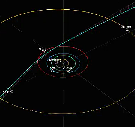
The dim space rock is currently at about magnitude 18.8. Our new visitor, A11pl3Z, will get its closest to the sun – at about 2 astronomical units (AU), or twice as far as Earth is from the sun – in October. As it reaches perihelion – its closest point to the sun – it should be moving at about 68 km/s relative to the sun, or at about 152,000 miles per hour.
The object’s calculated path through the solar system, shown by the blue line in the graphic to the right, as well as the object’s high speed, are why the astronomers think it is interstellar in origin. Both facts suggest it is coming from beyond the Oort cloud.
This is the third such object discovered, after Oumuamua (whose nature remains somewhat unknown), followed by Comet 21/Borisov.
UPDATE: The object has now been renamed 3I/Atlas. The “3I” indicates it is the third interstellar object discovered, and “Atlas” refers to the discovering telescope survey.


