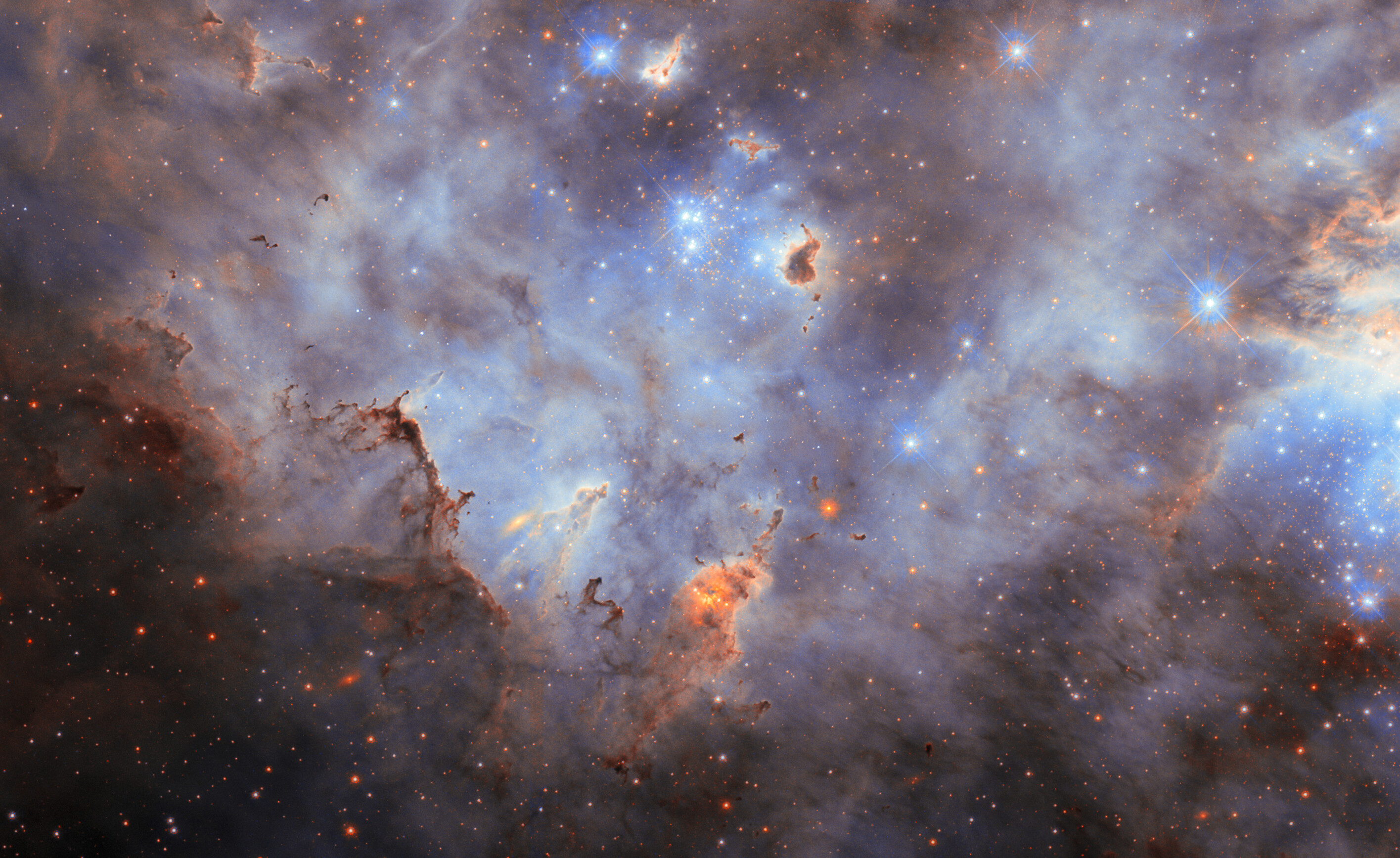
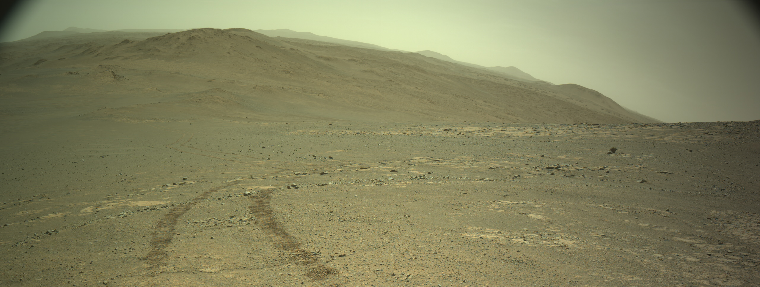
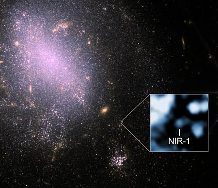
Returning to Mars’ glacier country

Overview map

Returning to Mars' glacier country
Click for original image.

Today’s cool image illustrates again why I rail against those who still claim Mars is dry. The picture to the right, cropped, reduced, and sharpened to post here, was taken on June 2, 2025 by the high resolution camera on Mars Reconnaissance Orbiter (MRO).

The picture was labeled simply as a “terrain sample” by the MRO camera team, which almost always signifies that it was taken not as part of any specific science research project or by request by a scientist, but to fill a gap in the camera’s schedule in order to maintain its proper temperature. When such a gap-filler picture is required, the team tries to pick interesting features in that time frame, but don’t always succeed.

In this case, that time frame placed MRO over the northern mid-latitudes and a region I label “glacier country” because practically every picture taken in this region shows glacial features. This picture is no exception. The white dot in the overview map above marks the location, in the Protonilus Mensae area of the 2,000-mile-long strip of glaciers. The arrow in the picture itself shows the downward grade of the glacial flow. The small 2,000-foot-wide crater appears as if the impact occurred on soft ice, and the stippled terrain surrounding it appears to resemble the feature geologists have labeled “brain terrain”, a surface feature unique to Mars and associated with near surface ice, though its exact formation process is not yet understood.

Nor have I cherry-picked this image to prove my point. Its glacial-like features are very typical for this region of Mars. Note for example the inset with the larger crater to the northeast. It appears almost buried by this glacial material, which has poured through the gap in its southwest quadrant to fill it. A close look at all the low lying terrain shows similar glacial-like flows.

Mars is surely not a paradise. It is bone-chillingly cold almost all the time. Its atmosphere is so thin and lacking in oxygen you would quickly suffocate if you tried to breath it. But the data continues to suggest that the red planet has ample supplies of near-surface ice outside of its dry tropics. All future colonists will need to do is dig a bit and process the water out.

1 comment

Another interstellar object identified entering the solar system

A11pl3Z's path through the solar system

Astronomers think they have identified another interstellar object that is now entering the solar system.

The dim space rock is currently at about magnitude 18.8. Our new visitor, A11pl3Z, will get its closest to the sun – at about 2 astronomical units (AU), or twice as far as Earth is from the sun – in October. As it reaches perihelion – its closest point to the sun – it should be moving at about 68 km/s relative to the sun, or at about 152,000 miles per hour.

The object’s calculated path through the solar system, shown by the blue line in the graphic to the right, as well as the object’s high speed, are why the astronomers think it is interstellar in origin. Both facts suggest it is coming from beyond the Oort cloud.

This is the third such object discovered, after Oumuamua (whose nature remains somewhat unknown), followed by Comet 21/Borisov.

UPDATE: The object has now been renamed 3I/Atlas. The “3I” indicates it is the third interstellar object discovered, and “Atlas” refers to the discovering telescope survey.

12 comments

Astronomers discover supernovae that apparently exploded twice

Double detonation supernova
Click for original picture.

Using the ground-based Very Large Telescope (VLT) in Chile, astronomers have discovered evidence suggesting a star apparently exploded twice went it went supernova several hundred years ago.

They detected this possibility by looking at the remnant of that blast, shown to the right. It shows a double halo, indicated by the blue and orange colors. The blue however is seen in both shells. As noted by the VLT’s press notice:

Calcium is shown in blue, and it is arranged in two concentric shells. These two layers indicate that the now-dead star exploded with a double-detonation.

This type of supernova, dubbed type 1a, occurs when a white dwarf sucks matter from its closely orbiting stellar companion. That material piles up on the surface of the star until it reaches critical mass and explodes, causing the supernova.

The two shells, suggesting a double detonation, fits a theory proposed for this process. From the paper’s abstract:

Our analysis reveals that the outer calcium shell originates from the helium detonation at the base of the outer envelope, while the inner shell is associated with the carbon–oxygen core detonation. This morphological distribution of intermediate-mass elements agrees qualitatively with the predicted signature of the double detonation of a sub-Chandrasekhar-mass white dwarf from a hydrodynamical explosion simulation.

In other words, the outer shell resulted from the explosion caused by the helium ripped from the companion star, with the resulting shockwave detonating the second explosion inside the white dwarf’s core.

That’s the theory at least. This data supports it, but it certainly doesn’t prove it.

1 comment

China releases images of Earth and Moon, taken by its Tianwen-2 asteroid probe

Tianwen-2 images of the Earth and the Moon
For original images go here and here.

According to a report today in China’s state-run press, its Tianwen-2 asteroid sample return spacecraft is operating normally, and has successfully taken pictures of both the Earth and the Moon to test its instrumentation.

Those images are to the right, cropped, reduced, and sharpened to post here.

The CNSA [China National Space Administration] said that the narrow-field-of-view navigation sensor equipped on the probe recently captured the images of Earth and the moon, demonstrating good functional performance.

The images released include a photograph of Earth obtained by Tianwen-2 when it was approximately 590,000 kilometers away from the planet, as well as a new photograph of the moon captured when it was about the same distance from the moon. After the images were transmitted back to the ground, they were processed and produced by scientific researchers.

The Tianwen-2 probe has currently been in orbit for over 33 days, at a distance from Earth exceeding 12 million kilometers, and it is in good working condition, the CNSA said.

The probe will take about a year to reach asteroid Kamo’oalewa, where it will fly in formation studying it for another year, during which time it will attempt to grab samples by two methods. One method is a copy of the touch-and-go technique used by OSIRIS-REx on Bennu. The second method, dubbed “anchor and attach,” is untried, and involves using four robot arms, each with their own drill.

3 comments

Baby stars illuminating the dust that surrounds them

Baby stars illuminating dark dust
Click for original image.

Cool image time! The picture to the right, cropped, reduced, and sharpened to post here, was taken by the Hubble Space Telescope showing the wispy bluish clouds made of dark dust that we can only see because the dust is illuminated by the reflected light from the five red and blue stars nearby. Think of the Moon, lit only by the reflected light of the Sun.

The photo however was not taken to study the clouds, but these baby stars, located in one of the closest star forming regions of the Milky Way.

GN 04.32.8 is a small part of the stellar nursery known as the Taurus Molecular Cloud. At only roughly 480 light-years from Earth in the constellation Taurus, it’s one of the best locations for studying newly forming stars. This reflection nebula is illuminated by the system of three bright stars in the centre of this image, mainly the variable star V1025 Tauri in the very centre. One of those stars overlaps with part of the nebula: this is another variable star that is named HP Tauri, but is classified as a T Tauri star, for its similarity to yet another variable star elsewhere in the Taurus Molecular Complex. T Tauri stars are very active, chaotic stars at an early stage of their evolution, so it’s no surprise that they appear in a prolific stellar nursery like this one! The three stars are also named HP Tau, HP Tau G2 and HP Tau G3; they’re believed to be gravitationally bound to each other, forming a triple system.

Eagle-eyed viewers might notice the small, squashed, orange spot, just left of centre below the clouds of the nebula, that’s crossed by a dark line. This is a newly-formed protostar, hidden in a protoplanetary disc that obstructs some of its light. Because the disc is edge-on to us, it’s an ideal candidate for study. Astronomers are using Hubble here to examine it closely, seeking to learn about the kinds of exoplanets that might be formed in discs like it.

As beautiful as this image is, it is that tiny protostar near the bottom that likely attracts the most interest from astronomers.

3 comments

The sagging flank of one of Mars’ giant volcanoes

The sagging flank of Elysium Mons
Click for original image.

Cool image time! The picture to the right, rotated, cropped, reduced, and sharpened to post here, was taken on May 1, 2025 by the high resolution camera on Mars Reconnaissance Orbiter (MRO). It shows what the science team labels a “chain of pit craters in [a] graben”.

A graben is a surface fissure created when the surface either spreads or two sections shift sideways in opposite directions. The chain of pits suggest that there is a larger void below into which the surface is sinking. It is also likely that a lot of the sinking material is volcanic ash, thrown free in an eruption hundreds of millions of years ago, which over the eons has been blown up to this location to settle in the crack to fill it. It is now trapped there, and sinking.

What caused the ground here to shift and create the fissure? In this case, the cause is quite large and massive, in a way that boggles the mind.
» Read more

2 comments

Webb takes infrared image of exoplanet

Webb's image of exoplanet

Using the Webb Space Telescope astronomers have now successfully taken an infrared false-color image of Saturn-sized exoplanet orbiting a young star about half the mass of the Sun and about 111 light years away.

The image is to the right, cropped and reduced to post here. The star, its light blocked out, is indicated by the circle with the star in the middle. The exoplanet is the orange blob to the upper right, sitting inside the blue accretion disk that surrounds the star, photographed in optical light by the Very Large Telescope in Chile.

You can read the paper here. The scientists rejected the possibility that this was a background galaxy after doing computer modeling, based on the data available. From their paper:

Dedicated N-body simulations were conducted for a planet with a mass of 0.34 [mass of Jupiter], located at 52 au [astronomical units] around the 0.46 [solar mass] central star. This value is consistent with the measured projected separation, assuming that the planet and the ≈13°-inclined disk are coplanar. The simulation also included a disk of 200,000 planetesimals, distributed between 20 and 130 au. These parameters were selected to roughly match the boundaries of the observed disk.

Note too that the picture to the right has been significantly enhanced by the press department at JPL, based on the actual data shown in the paper itself. These fact underline the uncertainties involved in this discovery.

Nonetheless, it is a good result, and suggests we are looking at the formation process of a new solar system surrounding a very young baby star.

2 comments

Curiosity’s future travels uphill

The view uphill
Click for full resolution. For original images go here and here.

Overview map
Click for interactive map.

Cool image time! The panorama above, assembled from two pictures taken on June 23, 2025 (here and here) by the left navigation camera on the Mars rover Curiosity, looks to the south and uphill into the canyon that the rover will eventually climb.

The overview map to the right provides context. The blue dot marks Curiosity’s present location, the white line its past travel route, and the red dotted line its future route. The yellow lines indicate the approximate area covered by the panorama.

The science team is presently exploring the boxwork formation on the right, and should spend at least the next month or so there before moving on. As the rover moves up into this canyon we should also expect the science team to spend a great deal of time studying that many layered cliff face to the right.

Eventually the rover will enter those white very hilly regions on the horizon. No route through those hills however has yet been chosen.

0 comments

A graceful spiral galaxy

A graceful spiral galaxy
Click for original image.

Cool image time! The picture to the right, cropped, reduced, and sharpened to post here, was taken by the Hubble Space Telescope as part of a project to study galaxies with very active central supermassive black holes.

What sets UGC 11397 apart from a typical spiral lies at its centre, where a supermassive black hole containing 174 million times the mass of the Sun is growing. As a black hole ensnares gas, dust, and even entire stars from its vicinity, this doomed matter heats up and puts on a fantastic cosmic light show. Material trapped by the black hole emits light from gamma rays to radio waves and can brighten and fade without warning. But in some galaxies, including UGC 11397, thick clouds of dust hide much of this energetic activity from view in optical light. Despite this, UGC 11397’s actively growing black hole was revealed through its bright X-ray emission — high-energy light that can pierce the surrounding dust. This led astronomers to classify it as a Type 2 Seyfert galaxy, a category used for active galaxies whose central regions are hidden from view in visible light by a doughnut-shaped cloud of dust and gas.

To me what sets this galaxy apart is its natural beauty. It also reminds me of the universe’s vastness. Located about 250 million light years away, those hazy spiral arms represent millions of stars, many of which likely harbor planets and maybe even life.

0 comments

Scientists discover unexpected mineral in Ryugu asteroid sample

Scientists analyzing the samples brought back from the rubble pile asteroid Ryugu by Japan’s Hayabusa-2 spacecraft have now discovered an unexpected mineral, dubbed djerfisherite, that the formation theories of the asteroid say should not be there.

“Djerfisherite is a mineral that typically forms in very reduced environments, like those found in enstatite chondrites, and has never been reported in CI chondrites or other Ryugu grains,” says first and corresponding author Masaaki Miyahara, associate professor at the Graduate School of Advanced Science and Engineering, Hiroshima University. “Its occurrence is like finding a tropical seed in Arctic ice—indicating either an unexpected local environment or long-distance transport in the early solar system.”

At present the scientists propose two hypotheses for explaining the mineral. Either it came from another asteroid as Ryugu was congealing, or it formed in Ryugu when conditions raised its temperature above 350 degrees Celsius. The researchers now favor the latter theory, even though the generally accepted histories of Ryugu’s formation never included such conditions.

2 comments

Two lunar orbiters spot the crash site of Ispace’s Resilience lander

Resilience crash site on the Moon, as seen by Chandrayaan-2

Scientists using both NASA’s Lunar Reconnaissance Orbiter (LRO) and India’s Chandrayaan-2 lunar orbiter have spotted the crash site for the private commercial lunar lander Resilience, built and launched by the Japanese startup Ispace.

The picture to the right was taken by Chandrayaan-2. As noted at the LRO website showing its photo:

The dark smudge (60.4445°N, 355.4120°E, -2431.6 m elevation ) formed as the vehicle excavated and redistributed shallow regolith (soil); the faint bright halo resulted from low-angle regolith particles scouring the delicate surface.

The lander attempted a soft landing on June 5, 2025, but because its laser rangefinder was unable to gather good data as to its elevation, it did not decelerate properly and was going too fast when its engines tried for a soft landing. It instead crashed.

4 comments

New nova spotted and now visible to the naked eye

Astronomers have now spotted a brand new nova in the southern hemisphere that has quickly brightened so that is now just visible to the naked eye.

On June 12th (June 12.9 UT), the All-Sky Automated Survey for Supernovae (ASAS-SN) discovered a new 8.7-magnitude stellar object in Lupus. Not long after, Yusuke Tampo, with the South African Astronomical Observatory (University of Cape Town), obtained a spectrum of the “new star” and identified it as a classical nova based on its spectral features and dramatic increase in brightness.

The nova went through a slew of temporary names — AT 2025nlr, ASASSN-25cm, and N Lup 2025 — until receiving its official designation V462 Lupi on June 16th. Since discovery, the nova has brightened rapidly. As of 3 p.m. Eastern Time June 17th, it’s at magnitude 6.1, and visible without optical aid from a dark-sky location. Its rise has been phenomenal when you consider that prior to the explosion, the progenitor star was approximately magnitude 22.3 (in the blue band) according to American Association for Variable Stars (AAVSO) observer Sebastián Otero, who dug up an older image from a photographic plate.

Though in the southern hemisphere, this nova star is also visible in the northern hemisphere to the mid-latitudes. The article at the link provides some details if you wish to try spotting it.

Novae occur when a central heavy white dwarf star robs enough material from its closely orbiting stellar companion. When enough material piles up on the surface of the white dwarf it goes critical, resulting in a thermonuclear explosion strong enough to produce the nova.

Whether the nova will continue to brighten remains unknown, but I guarantee that a plethora of amateur astronomers will watching to find out.

Hat tip to BtB’s stringer Jay.

1 comment

The source of a Martian glacial canyon 750 miles long

The source of a Martian glacial canyon 750-miles-long
Click for original image.

Cool image time! The picture to the right, cropped, reduced, sharpened, and brightened to post here, was taken on May 1, 2025 by the high resolution camera on Mars Reconnaissance Orbiter (MRO).

The scientists label this very simply as a “wall on Ausonia Cavis”. Ausonia Cavis — 31 miles long and 20 miles wide at its widest — is one of the many gigantic sinks found in many places on Mars. This particular cliff wall is about 2,000 feet high, though from rim to floor of the sink is closer to 3,000 feet.

The image was likely taken to get a closer look at those gullies flowing down the cliff wall. Previous research of similar cliff walls in this region has found what appears to be seasonal water frost in such gullies, and this image was likely taken to see if more such frost could be spotted here as well.
» Read more

0 comments

Sublimating ice in the Martian dry tropics?

Sublimated ice in the Martian dry tropics?
Click for original image.

Cool image time! The picture to the right, cropped, reduced, and sharpened to post here, was taken on May 3, 2025 by the high resolution camera on Mars Reconnaissance Orbiter (MRO). Labeled merely as a “terrain sample,” it was likely snapped not as part of any specific research project but to fill a gap in the camera’s schedule so as to maintain the camera’s proper temperature.

When the MRO camera team does this, they try to pick features of interest at the time required, and I think succeed more often than not. In this case, they captured this one-mile-wide unnamed crater that appears to be filled with sublimating glacial debris. Similarly, the plateau surrounding the crater seems to also show signs that some sublimation is occurring of ice just below the surface, producing the areas that appear filled with pockmarks.

The location however suggests that if near surface ice here is sublimating away, it hints at a find of some significance.
» Read more

2 comments

Mars will be mystery until we can walk its surface

A Martian mystery
Click for original image.

Today’s cool image illustrates starkly the limitations of orbital imagery. The picture to the right, rotated, cropped, reduced, and sharpened to post here, was taken on March 30, 2025 by the high resolution camera on Mars Reconnaissance Orbiter (MRO). It shows flow features inside a depression that strongly resemble glacial features, with the downhill grade roughly heading south.

Such features are seen in many places on Mars, almost always in the 30 to 60 degree mid-latitude bands in both the northern and southern hemispheres (see here, here, and here for just three examples. For many more simply search this website using “glacier” or “glacial feature” as search terms).

The problem is that this location is not within that 30 to 60 degree latitude band. In fact, at this location no near surface ice should exist at all.
» Read more

2 comments

The mad mountains of Mars

The mad mountains of Mars
Click for original image.

Overview map
Click for interactive map

Cool image time! The picture above, cropped to post here, was taken on June 10, 2025 by the high resolution camera on the Mars rover Curiosity, and shows some of the stranger terrain found higher up the flanks of Mount Sharp in Gale Crater.

The blue dot on the overview map to the right marks Curiosity’s present position, where it is doing another drilling campaign into the first boxwork geology it has encountered. The white line marks its past travels, while the green dotted line its planned route.

The yellow lines indicate the area seen in the picture above. The wild mountain peaks on the horizon are part of the sulfate-bearing unit that appears very bright in the overview map. The material that makes up this terrain appears to be very easily eroded, based on its features as seen from orbit, as well as Curiosity’s distant view. Whether that erosion was wind, water, or ice, remains undetermined, and is the main question Curiosity will attempt to answer once it gets there, likely in a year or so.

Regardless, the landscape appears almost like it soft sand being washed away.

Where the rover will go next the science team has not yet decided. It will definitely continue uphill, but they do not yet know the route they will take through that sulfate-bearing unit.

3 comments

Europe’s Solar Orbiter takes first images of the Sun’s south pole

The south pole of the Sun
Click for original image.

Because its orbit has now dropped 17 degrees below the ecliptic plane of the solar system, the European Space Agency’s (ESA) Solar Orbiter probe has been able to snap the first images of the Sun’s south pole, as shown by the two pictures to the right.

The [two images show] the Sun’s south pole as recorded on 16–17 March 2025, when Solar Orbiter was viewing the Sun from an angle of 15° below the solar equator. This was the mission’s first high-angle observation campaign, a few days before reaching its current maximum viewing angle of 17°.

The instruments each observe the Sun in a different way. PHI images the Sun in visible light (left) and maps the Sun’s surface magnetic field (right).

The magnetic field data on the right has revealed that at present the field at the pole is “a mess,” because the Sun is presently at solar maximum.

While a normal magnet has a clear north and south pole, the PHI instrument’s magnetic field measurements show that both north and south polarity magnetic fields are present at the Sun’s south pole. This happens only for a short time during each solar cycle, at solar maximum, when the Sun’s magnetic field flips and is at its most active. After the field flip, a single polarity should slowly build up and take over at the Sun’s poles. In 5–6 years from now, the Sun will reach its next solar minimum, during which its magnetic field is at its most orderly and the Sun displays its lowest levels of activity.

Solar Orbiter is now well positioned to observe the expected changes in the Sun’s magnetic field as sunspot activity ramps down to solar minimum.

0 comments

The dusky mountains of Mars

The dusky mountains of Mars
Click for high resolution. For the original images, go here, here, and here.

Overview map
Click for interactive map.

Cool image time! The panorama above, created from three images taken on June 7, 2025 (here, here, and here) by the high resolution camera on top of the Mars rover Curiosity, looks south and uphill into the Gediz Vallis canyon that the rover had been traveling previously.

The overview map to the right provides context. The blue dot Curiosity’s present position, where it is about to begin a drilling campaign into the first boxwork structures the rover has reached. The white dotted line marks its past travels, while the green dotted line its planned future route. The red dotted line marks a planned route that has been abandoned.

The yellow lines indicate approximately the area covered by the panorama. Because this used the rover’s high resolution camera, the view gives us a detailed look at the mountains on the distant horizon. Though we are looking uphill, the peaks in the distance are merely higher ridges and hills on the flanks of Mount Sharp. The mountain’s peak is out of view, about 25 miles away and about 15,000 feet higher up.

Note the dusty and what appears to be a softened nature of the terrain on these higher peaks. Since entering the foothills of Mount Sharp several years ago, the surface has been extremely rocky and rough, every inch covered in boulders of all sizes. This distant view suggests the ground might become easier to traverse at those higher altitudes. It also appears there will be a lot more dust, coating everything.

The lighting I think is close to natural. Because Mars is farther from the Sun, it doesn’t get as much light. Even during mid-day the light to our Earth-borne eyes would more resemble dusk on Earth.

0 comments

Ispace confirms that its Resilience lunar lander has failed, apparently crashing on the Moon

According to an update issued several hours after the planned landing, the Japanese lunar lander startup confirmed that its Resilience lunar lander apparently crashed in its attempt to soft land on the Moon.

Ispace engineers at the HAKUTO-R Mission Control Center in Nihonbashi, Tokyo, transmitted commands to execute the landing sequence at 3:13 a.m. on June 6, 2025. The RESILIENCE lander then began the descent phase. The lander descended from an altitude of approximately 100 km to approximately 20 km, and then successfully fired its main engine as planned to begin deceleration. While the lander’s attitude was confirmed to be nearly vertical, telemetry was lost thereafter, and no data indicating a successful landing was received, even after the scheduled landing time had passed.

Based on the currently available data, the Mission Control Center has been able to confirm the following: The laser rangefinder used to measure the distance to the lunar surface experienced delays in obtaining valid measurement values. As a result, the lander was unable to decelerate sufficiently to reach the required speed for the planned lunar landing. Based on these circumstances, it is currently assumed that the lander likely performed a hard landing on the lunar surface.

After communication with the lander was lost, a command was sent to reboot the lander, but communication was unable to be re-established.

This explanation fits with the very high velocity numbers seen as the spacecraft approached the surface, much higher than intended.

Ispace has now attempted to land on the Moon twice, with both landers crashing upon approach. In this sense its record is not quite as good as the American startup Intuitive Machines, which had two landers touch down but immediately tip over, causing both to fail.

Ispace presently has three contracts to build landers with NASA, JAXA (Japan’s space agency), and the European Space Agency. The American lander is being built in partnership with the company Draper. Whether this second failure today will impact any of those contracts is uncertain at this time.

14 comments

Landing of Ispace’s Resilience lander uncertain

Resilence landing

The landing of Ispace’s Resilience lander on the Moon at present appears uncertain, and could be a failure. Though the announcers of the live stream had warned beforehand that it might take awhile after the planned touchdown time to confirm a successful landing, the circumstances just before landing did not appear to go as expected.

At T-1:45 minutes, with the spacecraft at an altitude of 32 feet and still moving at a speed of 116 miles per minute, all telemetry disappeared from the broadcast. Mission controllers did then indicate the spacecraft was “pitching up”, which means it was re-orienting itself for landing. At that point however no further updates were provided. Moments later we could see the engineer in mission control in the lower left of the screen capture to the right, obviously disturbed by something.

In ending the live stream a few minutes later, with no further information, the announcers added that a full report will be made during a press conference later today.

4 comments
1 13 14 15 16 17 55