Studying the Moon by starlight

The Moon's south pole by starlight

In a paper published today in the Journal for Geophysical Research, Planets, the science team for Lunar Reconnaissance Orbiter describe how they have used starlight to peer into the permanently shadowed craters of the Moon’s north and south poles. Looking only during the lunar night, they measured the dim albedo of the Moon from reflected starlight. From this very weak signal they were able to cull two interesting facts about these very cold and very dark places.

  • The ground at the bottom of these craters is more porous than the surrounding unshadowed terrain.
  • There is evidence in the spectroscopy of 1 to 2% water frost in these craters.

» Read more

A breathtaking view of the Apollo 15 landing site

The Lunar Reconnaissance Orbiter team has released a wide angle side view image of the Apollo 15 landing site, showing the lunar module and the areas around Hadley Rille and the Apennine Mountain range that the astronauts explored using their lunar jeep. Below is a cropped close-up, showing the landing site near the top of the image with Hadley Rille near the bottom. Below the fold is a second image showing a wider view that includes the Apennine mountain slope that the astronauts drove their rover up.

Close up of Hadley Rille and Apollo 15 landing site

» Read more

The moon contains a vast resource of titanium

There’s gold in them hills! Actually, it’s titanium, and it’s on the Moon.

The highest titanium abundances on Earth are around 1 percent or less. The new map shows that in the [Moon’s] mare, titanium abundances range from about one percent to a little more than ten percent. In the highlands, everywhere TiO2 is less than one percent. The new titanium values match those measured in the ground samples to about one percent.

New images of Apollo landing sites on the Moon

The Lunar Reconnaissance Orbiter team have released new images of the Apollo 12, 14, and 17 landing sites on the Moon. Below is a cropped image of the Apollo 12 site, showing the trails left by astronauts Pete Conrad and Alan Bean when they walked from their lunar module to Surveyor 3, an unmanned lunar lander that had soft landed there two years earlier. The full image shows some incredible detail.

Apollo 12 landing site

When dust, pebbles, rocks, and boulders act like liquid

The science team of Lunar Reconnaissance Orbiter released an intriguing picture yesterday of what scientists call a granular flow down the side of a five mile wide crater on the far side of the moon. Looking at the image, one would swear that the darker material flowing down the slope of the crater rim is a lava flow frozen in place.

lunar granular flow

However, according to the scientists, that is not what it is. Instead, this is merely debris left behind from an avalanche.
» Read more

Prime real estate

The south pole of the moon

Since the 1990s, scientists have suspected that water-ice might be hidden in the forever-dark floors of the polar craters on the Moon. If so, these locations become valuable real estate, as they not only would provide future settlers water for drinking, the water itself can be processed to provide oxygen and fuel.

Moreover, the high points near these craters, including the crater rims, are hoped to be high enough so that the sun would never set or be blocked by other mountains as it made its circuit low along the horizon each day. If such a place existed, solar panels could be mounted there to generate electricity continuously, even during the long 14-day lunar night.

Below the fold is a six minute video, produced from images taken by Lunar Reconnaissance Orbiter (LRO) from February 6, 2010 to February 6, 2011, in an effort to find out if such a place actually exists. It shows how the sunlight hits the south pole across an entire year.
» Read more

Exploring the floor of Copernicus

thumbnail of index of caves on floor of Copernicus

The Lunar Reconnaissance Orbiter website recently announced a new way to tour the Moon. The website, called QuickMap, allows a user with any home computer to zoom into any spot on the lunar surface and see the high resolution images being taken by Lunar Reconnaissance Orbiter.

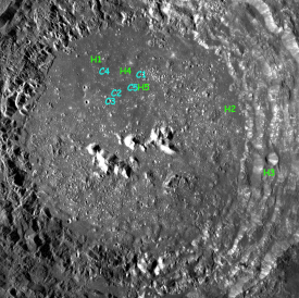
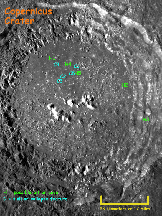
Using QuickMap, I spent a few hours this past weekend strolling about on the northern half of the floor of the crater Copernicus. It is in this area, annotated in the image on the right, that NASA engineer James Fincannon has already located a slew of collapse features and possible caves, the images of which I have posted previously on behindtheblack. (Click on the image or here to see a larger version of this updated index map.)

(You also can go sightseeing there if you wish. Go to QuickMap and zoom in on 10.1 latitude and -20.1 longitude to get to the floor of Copernicus. Or pick your own spot on the lunar surface and do some of your own exploring!)

What I found in the northern half of Copernicus’s floor was a plethora of possible caves and collapse features. Literally, the crater floor is littered with what appear to be pits, fissures, rills, and sinks. More significantly, sometimes the cave entrances line up with long straight collapse features, suggesting strongly the existence of extensive underground passages beyond the initial entrance pits.
» Read more

Global topography of the Moon

New results from Lunar Reconnaissance Orbiter, including a new global topographic map.

Global topography of the Moon

From the caption: A lunar topographic map showing the Moon from the vantage point of the eastern limb. On the left side of the Moon seen in this view is part of the familiar part of the Moon observed from Earth (the eastern part of the nearside). In the middle left-most part of the globe is Mare Tranquillitatis (light blue) the site of the Apollo 11 landing, and above this an oval-appearing region (Mare Serenitatis; dark blue) the site of the Apollo 17 landing. Most of the dark blue areas are lunar maria, low lying regions composed of volcanic lava flows that formed after the heavily cratered lunar highlands (and are thus much less cratered).

1 2 3 4