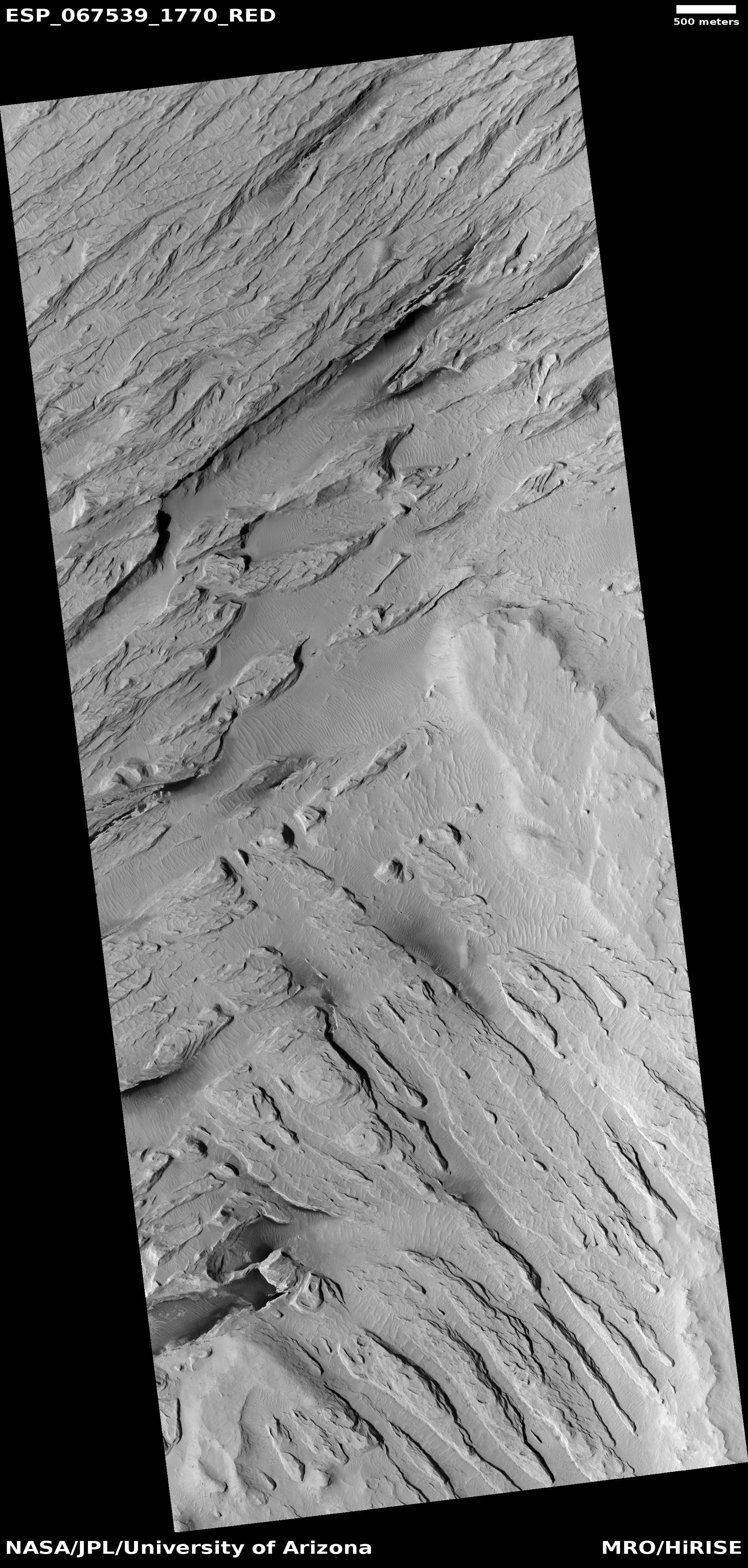
The endless volcanic ash of Mars’ Medusae Fossae Formation

The endless volcanic ash of Mars' Medusae Fossae Formation
Click for original image.

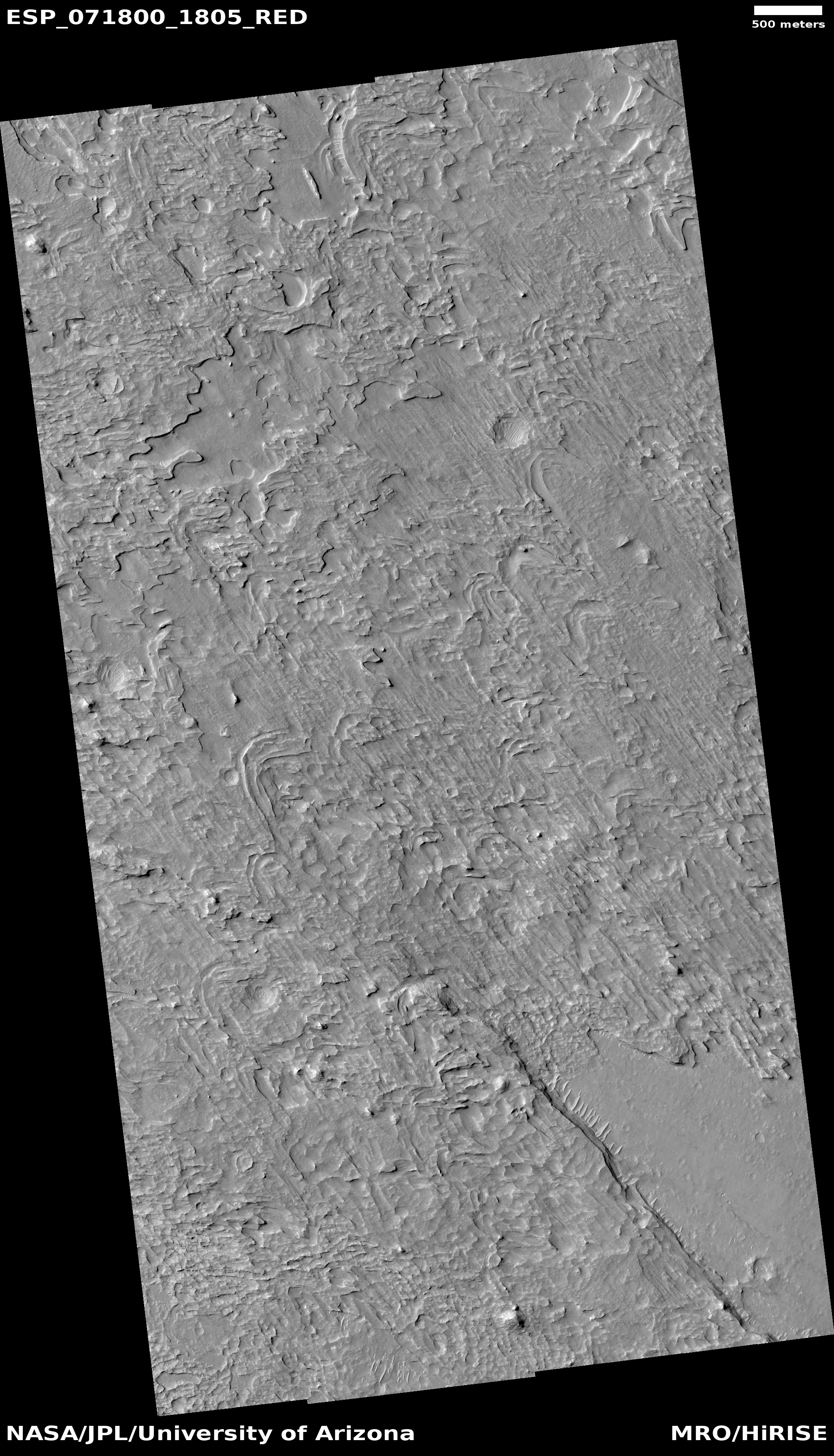
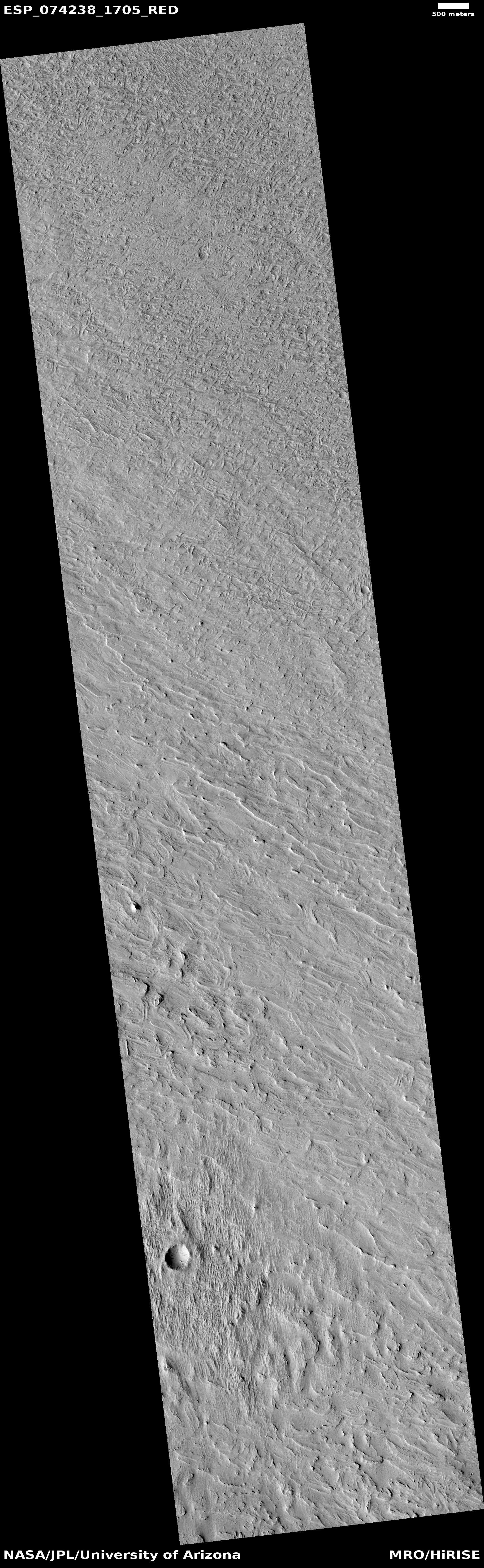
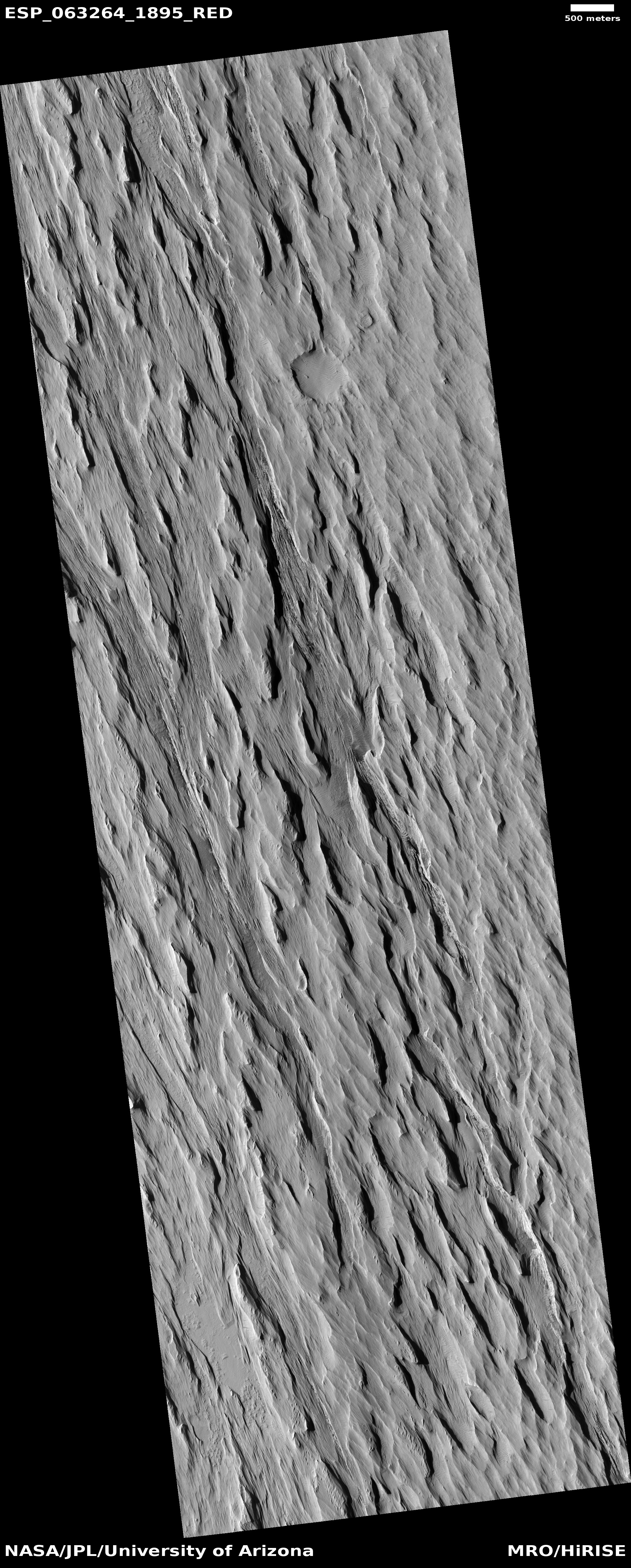
Cool image time! The picture to the right, cropped, reduced, and enhanced to post here, was taken on January 6, 2023 by the high resolution camera on Mars Reconnaissance Orbiter (MRO), and shows a small but typical area of the Medusae Fossae Formation, what is thought to be the largest volcanic ash deposit on Mars.

The picture itself was a “terrain sample,” taken by the MRO science team not as part of any specific research but to fill a gap in the camera’s schedule so as to maintain its temperature. The terrain itself looks like a field of sand that someone had run a fine comb across. In this case, the comb was the winds of Mars, prevailing from the southeast to the northwest. The crescent-like divots in the picture’s lower right are probably caused by some hard underground feature that the winds cannot blow away. Instead, it blows around, like water in rapids flowing around a rock, and takes the ash with it as it does so.
» Read more

A cliff face of volcanic erosion on Mars

A cliff face of volcanic erosion on Mars
Click for full image.

Today’s cool image is a variation of yesterday’s, showing another area on the edge of Mars’ largest volcanic ash field, dubbed the Medusae Fossae Formation and about the size of India. This time however the edge is an abrupt cliff, not the slow petering out of wind-shaped mesas.

The picture to the right, cropped, reduced, and sharpened to post here, was taken on August 27, 2022 by the high resolution camera on Mars Reconnaissance Orbiter (MRO). It shows what I very roughly estimate to be a 1,500 to 2,500 foot high cliff that appears to delineate the edge. To the north we have a plateau of intersperse layers of flood lava and ash. To the south those layers have eroded away, leaving a rough lava plain with a handful of scattered wind-sculpted mesas.

The overview map below, by providing a wider view of his region, makes its nature clearer.
» Read more

Another “What the heck?” formation on Mars

Another
Click for full image.

Cool image time! The photo to the right, cropped, reduced, and enhanced to post here, was taken on May 28, 2022 by the high resolution camera on Mars Reconnaissance Orbiter (MRO), and shows what the scientists label “unique terrain.”

I have increased the contrast to bring out the details. It appears that we have a flat plain of criss-crossing ridges that in large areas have somehow gotten flattened across their top. Imagine someone laying plaster on a wall and using a scraper tool to smooth the surface, but only partially. In this case on Mars, our imaginary worker only smoothed the surface a little, and only in some areas. To try to come up with a geological process however to explain this seems daunting.

And what created the criss-crossing ridges? The overview map provides only a little help in answering these questions.
» Read more

Zig-zag ridges on Mars

Zig-zag ridges on Mars
Click for full image.

Cool image time! The photo to the right, cropped and reduced to post here, was taken on April 9, 2022v by the high resolution camera on Mars Reconnaissance Orbiter (MRO). It shows a series of parallel zig-zag ridges in a flat, knobby terrain.

I don’t presume to explain this at all. According to one research paper,

This interplana region consists of extensive networks of ridges—the eponymous Aeolis Dorsa—and is interpreted as having formed by topographic inversion of fluvial and alluvial deposits.

Why these ridges zig-zag however does not seem to fit into either a fluvial or alluvial explanation, both of which involve the flow of water. The quote implies these could be inverted stream channels (where the compacted streambed becomes a ridge when the surrounding terrain erodes away), but once again, the distinct zig-zag pattern seems wrong. Rivers meander, but they don’t generally turn right and left so sharply. And why should we see parallel zig-zags? This doesn’t seem to fit with a river channel origin.

The particular location, as shown on the overview map below, is close to the dry Martian equator, on the edge of Medusae Fossae Formation, the largest field of volcanic ash dust on Mars.
» Read more

Wavy crescent ridges on Mars

Wavy crescents on Mars
Click for full image.

Cool image time! The photo to the right, cropped and reduced to post here, was taken on November 19, 2021 by the high resolution camera on Mars Reconnaissance Orbiter (MRO). It shows what the science team has labeled “Crescentic forms,” which in some ways resemble crescents that I featured in a cool image back in November 2020.

Unlike those earlier crescents, today’s are linked together to form a longer wavy line. Furthermore, today’s crescents include some positive relief, with some parts standing above the surrounding terrain. The earlier crescents were entirely carved out of the ground, forming depressions.

And yet, the method of formation for both must be somewhat similar. I say this based on their location, as shown in the overview map below.
» Read more

Scientists: Martian topography in one region suggests the past existence of lakes and river networks, but not a large single ocean

Based on a just published paper, scientists using orbital topography data and imagery have concluded that more than three billion years ago on Mars ancient rivers in the transition zone between the southern cratered highlands and the northern lowland plains fed into numerous lakes in the lowlands, not a single large ocean as some scientists posit.

From their abstract:

The northern third of Mars contains an extensive topographic basin, but there is conflicting evidence to whether it was once occupied by an ocean-sized body of water billions of years ago. At the margins of this basin are the remnants of deltas, which formed into water, but the size and nature of this water body (or water bodies) is unclear, and detailed investigations of different regions of the basin margins are necessary.

In this study, we use high-resolution image and topographic datasets from satellites orbiting Mars to investigate a series of water-formed landforms in the Memnonia Sulci region, set along the boundary of Mars’s northern basin. These landforms likely formed billions of years ago, providing evidence for ancient rivers and lakes in this region. The geologic evolution of these rivers and lakes was complicated, likely influenced by water-level fluctuations, changes in sediment availability, and impact cratering. Our topographic analysis of these rivers and lakes suggests that they terminated in a series of ancient lake basins at the boundary of Mars’s northern basin, rather than supplying a larger, ocean-sized body of water. [emphasis mine]

Overview map

The Memnonia Sulci region is in the cratered highlands just south of the Medusae Fossae Formation, the largest volcanic ash deposit on Mars. The region of study in it is marked by the blue dot in the overview map to the right.

The study does not preclude the possible existence of a northern ocean on Mars, but it says that at least in this region at the equator, it did not exist. Instead, the various river valleys drained into separate smaller and relatively short-lived lakes.

U-shaped meandering Martian ridge

Broad U-Shaped meandering ridge on Mars
Click for full image.

Cool image time! The photo to the right, rotated, cropped, and reduced to post here, was taken on December 3, 2021 by the high resolution camera on Mars Reconnaissance Orbiter (MRO). It shows what the scientists label a “Broad U-Shaped Ridge”. The two black squares are merely areas where no data was gathered.

Is this a fossilized river, of which scientists have identified more than 10,000 in the Arabia Terra transition region between the northern lowland plains and the southern cratered highlands? Arabia Terra however is literally on the other side of Mars, very far away.

The location, as shown in the overview map below, instead suggests that, if this U-shaped meander is a fossilized river, it isn’t one created by water or ice.
» Read more

A clue to the Martian history of volcanic eruptions

Dark layers in Medusae Fossae Formation
Click for full image.

Anyone who has taken even a single glance at a map of Mars cannot help but recognize that the red planet was once engulfed with repeated gigantic volcanic eruptions able to build numerous volcanoes larger than anything seen anywhere else in the solar system.

The cool image to the right, rotated, cropped, and enlarged to post here, provides a clue into those past eruptions, now thought to have been active for more than several billion years, with the most recent large activity ending several tens of millions of years ago. The photo was taken on May 7, 2021 by the high resolution camera on Mars Reconnaissance Orbiter (MRO), and shows just one tiny portion of the vast Medusae Fossae Formation, the largest thick volcanic ash deposit on Mars, about the size of India and what scientists think is the source of most of the planet’s dust.

What makes this picture interesting are the dark layers in the lower hollows. They indicate that this deposit was placed down in multiple eruptions, some of which produced material that appears dark blue in MRO images, and suggest that eruption was different than previous and subsequent eruptions.

The white cross on the overview map below notes the location of this picture in the Medusae Fossae Formation.
» Read more

The wind-swept volcanic ash plains of Mars

Overview map

Cool image time! In Mars’ volcano country lies the planet’s largest ash deposit, dubbed the Medusae Fossae Formation. Scientists believe that this gigantic deposit, with a size comparable to the nation of India, was laid down by muliple volcanic eruptions over several billion years and is the source of most of the dust seen on the Red Planet.

The overview map on the right shows the location of this ash deposit on Mars. The white cross indicates the location of today’s cool image, found below.
» Read more

Ice under Mars’ biggest volcanic ash field, at the equator?

Wind eddies on Mars
Click for full image.

According to new data obtained from the radar instruments on Mars Reconnaissance Orbiter (MRO) and Mars Express, scientists now think that the Medusae Fossae Formation, Mars’ biggest volcanic ash field and thought by some to be the source of most of the planet’s dust, might have an underground layer of ash that is also ice-rich. From their abstract:

The Medusae Fossae Formation (MFF) on Mars covers a vast area along the boundary between the rugged southern highlands and the smooth northern plains. While the MFF appears to be thick sediments or volcanic ash slowly eroding in the martian winds, how this material was emplaced remains mysterious. Most intriguing is evidence suggesting that some areas of the MFF may contain water ice. In this work we use sounding radar data from the SHARAD instrument on the Mars Reconnaissance Orbiter to probe up to 600 m below the surface and measure the electrical properties of the MFF material. The results suggest that the shallow parts of the MFF deposits are very porous and compress readily under their own weight. To match deeper probing by the Mars Advanced Radar for Subsurface and Ionosphere Sounding instrument on Mars Express requires a second layer of either vast porous deposits or ice‐rich material protected from sublimation by the dry sediments.

The MRO image above, originally posted here in November 2020, shows one example of the typical wind erosion found in the Medusae ash field. Apparently the ground-penetrating radar from orbit now suggests the possibility that there is an ash layer rich in ice, at depths beginning somewhere between 1,000 to 2,000 feet below the surface.
» Read more

Layers upon layers of Martian volcanic ash

Layers upon layers of Martian volcanic ash
Click for full image.

Today’s cool image provides I think a hint at the vast amount of time that has passed on Mars, allowing uncounted major events to occur which each lay down a bit of the geological history, a history that is now piled up on the surface so deeply that it will take decades of research to untangle it.

The photo to the right, cropped and reduced to post here, was taken on December 23, 2020 by the high resolution camera on Mars Reconnaissance Orbiter (MRO). It shows the layered nature of the Medusae Fossae Formation, the largest volcanic ash deposit on Mars (about the land area of India) and thought by some to be the source of most of the dust across the entire red planet.
» Read more

A Martian “glacier” made of volcanic ash

A Martian
Click for full image.

Of the numerous cool images I’ve posted on Mars, many have documented the growing evidence that in the mid-latitudes of the Red Planet are many buried glaciers of ice.

Today’s cool image to the right, rotated, cropped and reduced to post here, shows something that at first might resemble the features one would expect from an ice glacier, but in reality is actually a flow of volcanic ash being blown almost like a river, with the prevailing winds blowing from the south to the north.

The photo was taken by the high resolution camera on Mars Reconnaissance Orbiter (MRO) on November 1, 2020. The location, very close to the equator and in the transition zone dubbed the Cerberus Plains, is also smack dab between Mars’s biggest volcanoes, a region I like to dub Mars’s volcano country. The overview map below gives the context.
» Read more

Giant wind eddies in the sands of Mars

Wind eddies on Mars
Click for full image.

Cool image time! The image to the right, cropped and reduced to post here, was photographed by the high resolution camera on Mars Reconnaissance Orbiter (MRO) on August 5, 2020. It shows a cluster of the crescent-shaped gullies, apparently carved from desert sand by the prevailing winds.

Those prevailing winds here are from the southwest to the northeast. As the wind blows the sand to the east, it hits a more solid object, such as a mountain buried in the sand, which forces the wind and the blown sand to go around, much as water passes a boulder in river rapids. That solid object also causes an eddy to form at its face, the wind forced downward and then around and up, carving out the gullies by lifting the sand at the base of that solid object. The result are these crescent gullies, dubbed blow-outs.

The overview map helps explain why there is so much sand here, enough apparently to bury whole mountains.
» Read more

Deciphering the strange geology of Mars — or anything!

Eroding Medusae Fossae Formation ash deposits
Click for full image.

Today’s cool image is for once not taken by the high resolution camera on Mars Reconnaissance Orbiter (MRO). Instead, the image to the right, cropped and reduced to post here, was taken by Mars Odyssey on April 5, 2020, and shows the scouring and erosion caused by winds over many eons in a region dubbed Zephyria Planum. (Note that the image might fool your eye. Sunlight is coming from the east, and the rough terrain at the top is higher than the smooth plain at the bottom.)

Years ago, when I first started to rummage through the archives of images from the various Mars orbiters, I would have seen this image and posted it because I was completely baffled by what I saw, and thought that mystery made it worth showing to the public. Since then my incessant probing of research papers as well as asking a lot of questions of scientists has taught me a lot more about what scientists now surmise of the Martian geology. This greater knowledge in turn makes it possible for me to look at an image like this and immediately make a reasonable guess as to an explanation. This photo, while still containing much that is mysterious, is no longer completely baffling to me.

This willingness to ask questions and dig deeper is fundamental to all things. To have a deeper understanding and not simply guess about any subject, you always have to recognize that your assumptions are likely wrong, and that to learn anything you have to repeatedly ask what I call “the next question.” The first answer will force you to recognize that your first guesses are wrong, raise more questions, which in turn will lead to more questions, and then more questions, and so forth.

Whether I am researching Mars or early space history or politics, this rule always applies. Don’t leap to a conclusion. Think it possible you could be wrong. Ask the next question. And the next. You will repeatedly find that what you thought you knew was not correct, and in the end you will gain a deeper understanding of what is actually known about any subject, as well as what is unknown. And knowing the unknowns is probably the most important thing you can learn.

To gain a better understanding of today’s particular image, our first questions must start with context. Where is this feature on Mars? What is the surrounding history of that location? And what is already known about this place?

The location immediately reveals a great deal, as shown in the overview map below.
» Read more

The eroding edge of Mars’ largest volcanic ash field

Eroding yardangs at the edge of Mars' largest volcanic ash field
Click for full image.

Cool image time! In the regions between the biggest volcanoes on Mars is the Medusae Fossae Formation, a immense deposit of volcanic ash that extends across as much surface area as the nation of India. As planetary scientist Kevin Lewis of Johns Hopkins University explained to me previously,

In general, much of the [formation] seems to be in net erosion now, retaining very few craters on the surface. …One hypothesis is that this long term erosion, since it’s so enormous, is the primary source of the dust we see covering the much of the planet’s surface.

The image above, cropped and reduced to post here, was taken by the high resolution camera on Mars Reconnaissance Orbiter (MRO) on January 25, 2020. It shows one very small area at the very edge of the Medusae ash deposit, in a region where that deposit is clearly being eroding away by the prevailing southeast-to-northwest winds. The mesas of this ash that remain are called yardangs, their ash more tightly pressed together so that it resists erosion a bit longer than the surrounding material.

In the context map below the location of these yardangs is indicated by the white cross, right on the edge of the Medusae ash field.
» Read more