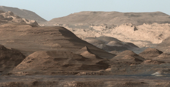
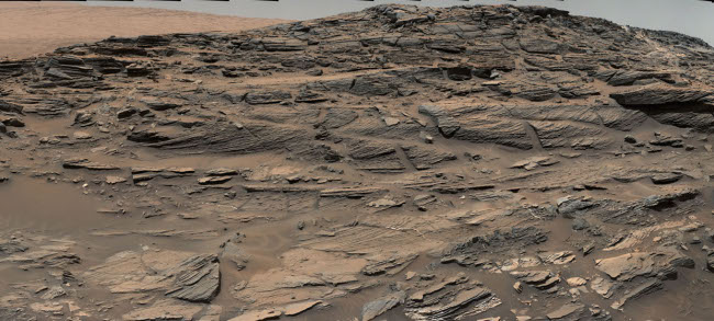
More confirmation from Curiosity of past lakes in Gale Crater

New data from Curiosity has now provided further confirmation that the deeper sedimentary layers seen in Gale Crater were likely formed far in the past by flowing water.

“Paradoxically, where there is a mountain today there was once a basin, and it was sometimes filled with water,” said John Grotzinger, the former project scientist for Mars Science Laboratory at the California Institute of Technology in Pasadena, and lead author of the new report. “We see evidence of about 250 feet (75 meters) of sedimentary fill, and based on mapping data from NASA’s Mars Reconnaissance Orbiter and images from Curiosity’s camera, it appears that the water-transported sedimentary deposition could have extended at least 500 to 650 feet (150 to 200) meters above the crater floor.”

Furthermore, the total thickness of sedimentary deposits in Gale Crater that indicate interaction with water could extend higher still, perhaps up to one-half mile (800 meters) above the crater floor.

Above 800 meters, Mount Sharp shows no evidence of hydrated strata, and that is the bulk of what forms Mount Sharp. Grotzinger suggests that perhaps this later segment of the crater’s history may have been dominated by dry, wind-driven deposits, as was once imagined for the lower part explored by Curiosity.

This was always the reason to go and climb Mount Sharp. As Curiosity heads uphill it begins to map out the geological history of Mars, first as a wet place with liquid water, then as a dry place in which the water is gone.

Curiosity’s future path

Looking up Mt Sharp

Cool image time! The Curiosity science team has produced another panorama of Mount Sharp and the regions that the rover will soon traverse.

This composite image looking toward the higher regions of Mount Sharp was taken on September 9, 2015, by NASA’s Curiosity rover. In the foreground — about 2 miles (3 kilometers) from the rover — is a long ridge teeming with hematite, an iron oxide. Just beyond is an undulating plain rich in clay minerals. And just beyond that are a multitude of rounded buttes, all high in sulfate minerals. The changing mineralogy in these layers of Mount Sharp suggests a changing environment in early Mars, though all involve exposure to water billions of years ago. The Curiosity team hopes to be able to explore these diverse areas in the months and years ahead. Further back in the image are striking, light-toned cliffs in rock that may have formed in drier times and now is heavily eroded by winds.

They have adjusted the colors, adding blue, so that things look as they would on Earth, in order to help the geologists understand what they are looking at.

Be sure and click on the link. The full resolution image is quite amazing. Like mountains on Earth, from a distance things look a lot simpler than they do once you get there. The slopes of Mount Sharp are complex and rugged, and will be a big challenge for Curiosity to traverse.

Moreover, this rough terrain illustrates that the Martian surface has, like Earth, been significantly shaped by erosion. The surface we see here is not the surface produced by the impact that produced the crater. It has been reshaped and eroded over many eons by many later processes, including wind and water.

Petrified sand dunes on Mars

Petrified sand dunes on Mars

Cool image time! A panorama produced from images taken by Curiosity’s Mast camera has revealed the remains of ancient sand dunes, cemented into sandstone and now eroding.

This sandstone outcrop — part of a geological layer that Curiosity’s science team calls the Stimson unit — has a structure called crossbedding on a large scale that the team has interpreted as deposits of sand dunes formed by wind. Similar-looking petrified sand dunes are common in the U.S. Southwest. Geometry and orientation of the crossbedding give information about the directions of the winds that produced the dunes.

The Stimson unit overlies a layer of mudstone that was deposited in a lake environment. Curiosity has been examining successively higher and younger layers of Mount Sharp, starting with the mudstone at the mountain’s base, for evidence about changes in the area’s ancient environment.

The image above is cropped and reduced in resolution. Be sure to look at the original.

This report also suggests that Curiosity is definitely moving up the geological layers on Mount Sharp. With each layer, we learn a little bit more about the complex geological history of Gale Crater.

Curiosity confirms that Gale Crater was once a water filled lake.

New geological data from Curiosity suggests that the interior of Gale Crater was shaped by sediments placed there by the rise and fall of a lake over millions of years.

The data also confirms that conditions on Mars were good enough for liquid water to be maintained on the surface for long periods of time. The problem is that scientists still do not understand how Mars could have maintained such kind of atmosphere and environmental conditions, based on its location and size.

A geological score for Curiosity!

Spectroscopy from Curiosity’s most recent drilling has been found to match and thus confirm the spectroscopy of the same spot taken years ago from orbit.

In observations reported in 2010, before selection of Curiosity’s landing site, a mineral-mapping instrument on NASA’s Mars Reconnaissance Orbiter provided evidence of hematite in the geological unit that includes the Pahrump Hills outcrop. The landing site is inside Gale Crater, an impact basin about 96 miles (154 kilometers) in diameter with the layered Mount Sharp rising about three miles (five kilometers) high in the center.

“We’ve reached the part of the crater where we have the mineralogical information that was important in selection of Gale Crater as the landing site,” said Ralph Milliken of Brown University, Providence, Rhode Island. He is a member of Curiosity’s science team and was lead author of that 2010 report in Geophysical Research Letters identifying minerals based on observations of lower Mount Sharp by the orbiter’s Compact Reconnaissance Imaging Spectrometer for Mars (CRISM). “We’re now on a path where the orbital data can help us predict what minerals we’ll find and make good choices about where to drill. Analyses like these will help us place rover-scale observations into the broader geologic history of Gale that we see from orbital data.”

This is a significant finding. Not only does this data now prove that the orbital data is correct, it demonstrates that scientists can now use that orbital data to direct Curiosity to even more interesting geological surface features. In fact, this ground-based data will help them calibrate all their orbital data more precisely, thus making our geological knowledge of Mars more accurate and reliable.

Curiosity to begin climbing

Scientists have decided to begin Curiosity’s climb of Mount Sharp immediately rather than continue a planned traverse along the base of the mountain prior to heading uphill.

Curiosity’s trek up the mountain will begin with an examination of the mountain’s lower slopes. The rover is starting this process at an entry point near an outcrop called Pahrump Hills, rather than continuing on to the previously-planned, further entry point known as Murray Buttes. Both entry points lay along a boundary where the southern base layer of the mountain meets crater-floor deposits washed down from the crater’s northern rim.

The issues with Curiosity’s wheels also played a part in this decision.

Curiosity retreats from Hidden Valley

Finding its sandy floor slipperier than expected, engineers have backed Curiosity out of Hidden Valley to drill some holes while they reassess the rover’s route.

The rover’s wheels slipped more in Hidden Valley’s sand than the team had expected based on experience with one of the mission’s test rovers driven on sand dunes in California. The valley is about the length of a football field and does not offer any navigable exits other than at the northeastern and southwestern ends. “We need to gain a better understanding of the interaction between the wheels and Martian sand ripples, and Hidden Valley is not a good location for experimenting,” said Curiosity Project Manager Jim Erickson of JPL. …

Curiosity reversed course and drove out of Hidden Valley northeastward. On the way toward gaining a good viewpoint to assess a possible alternative route north of the valley, it passed over the pale paving stones on the ramp again. Where a rover wheel cracked one of the rocks, it exposed bright interior material, possibly from mineral veins.

More and more, the journey to Mount Sharp appears to be increasingly adventurous for the rover.

Curiosity’s journey continues

After more than a full Martian year, Curiosity has finally traveled beyond the area of its initial landing zone.

The 1-ton Curiosity rover has now cruised out of its landing ellipse, the area — about 4 miles wide by 12 miles long (7 by 20 kilometers) — regarded as safe ground for its August 2012 touchdown within Mars’ huge Gale Crater, NASA officials said.

The interesting factoid from this article is how much smaller this landing zone was for Curiosity compared to all other previous landers, illustrating how the technology has advanced during the last four decades since Viking.

The Curiosity science team celebrates the completion of a full Martian year since the rover’s landing.

The Curiosity science team celebrates the completion of a full Martian year since the rover’s landing.

This is mostly a press event aimed at convincing the world that the project is accomplishing its goals. Though they are justified in touting the many significant things about Mars and the past environment in Gale Crater that Curiosity has uncovered, we mustn’t forgot that the main goal was always to climb the slopes of Mt Sharp in order to study its geological layers and thus the long term geological history of Mars. The rover has not yet done this, and because of the greater-than-expected wheel damage the rover is experiencing, is at risk of not being able to get where it has to go.

The promised land: where Curiosity is headed.

The promised land: where Curiosity is headed.

This image (cut out from a mosaic) shows the view from the landing site of NASA’s Curiosity rover toward the lower reaches of Mount Sharp, where Curiosity is likely to begin its ascent through hundreds of feet (meters) of layered deposits. The lower several hundred feet (meters) show evidence of bearing hydrated minerals, based on orbiter observations. The terrain Curiosity will explore is marked by hills, buttes, mesas and canyons on the scale of one-to-three story buildings, very much like the Four Corners region of the western United States.

Click through to the image itself. Like all mountains, what appears to be a featureless mountainside from a distance instead becomes a complex and rough terrain in close-up.

1 5 6 7