Jupiter’s upper clouds

Jupiter's upper clouds

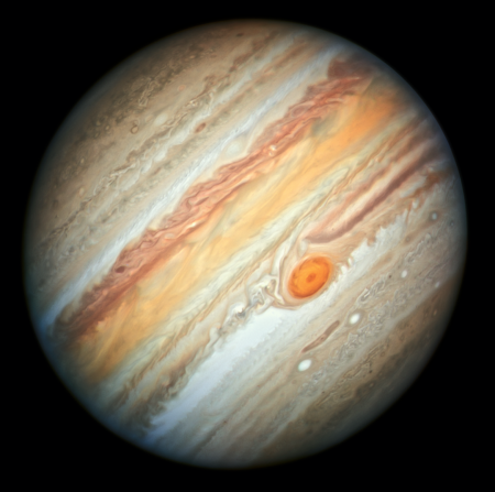
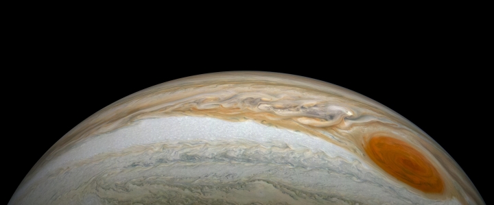
Cool image time! The photograph on the right, reduced to post here, was created by citizen scientists Gerald Eichstädt and Seán Doran from the raw images taken by Juno during the spacecraft’s 16th close fly-by of Jupiter on October 29, 2018. If you click on it you can see the full resolution image.

At the time, Juno was about 4,400 miles (7,000 kilometers) from the planet’s cloud tops, at a latitude of approximately 40 degrees north.

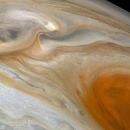
What attracts me to this image is its dimensionality. First, it looks at Jupiter from an oblique angle. Second, the shadows of the upper clouds can clearly be seen being cast on the lower clouds. Third, if you look at the full resolution image you can even see this effect in the middle of the big white storm in the image’s top left.

What frustrates me about this image is that Juno is not in an orbit around Jupiter allowing it to make extended movies of the evolution of these cloud features. Gaining even a limited understanding the meteorology of this gas giant will simply not be possible until we can do this, and that will require many satellites orbiting the planet.

Europe picks landing site for its ExoMars 2020 rover

The European Space Agency (ESA) has chosen the landing site for its ExoMars 2020 rover, a generally flat area with scattered craters dubbed Oxia Palum.

After over 4 years of careful study of HiRISE and more recently CaSSIS images Oxia Planum was chosen because scientists were convinced that its fine grained sediments, deposited during the ancient Noachian epoch were ideally suited for the Exobiology rover. With an enormous catchment area the sediments will have captured organics from a wide variety of environments over a long period of time, including areas where life may have existed. The fine sediments should also be ideal for the ExoMars drill – it aims to get to 2 metres depth.

Remote identification with the Mars Express and Mars Reconnaissance Orbiter Infrared spectrometers shows the presence of clays and other minerals giving clues to its aqueous history. A large group of scientists have been working on proposing, characterising and down selecting the sites, all of which had fascinating aspects, but Oxia Planum is the clear winner on both science and engineering constraints.

Based on my analysis of the last two candidate sites, I would guess that they also picked Oxia Planum because it is less spectacular, flatter, and thus poses less risk. It also means the images from there will be a bit more boring for the ordinary person.

Mars rover update: November 8, 2018

Summary: Curiosity finally gets drill samples from the top of Vera Rubin Ridge. Opportunity’s silence now extends to five months.

For a list of past updates beginning in July 2016, see my February 8, 2018 update.

Curiosity

Curiosity's travels on and off Vera Rubin Ridge

For the overall context of Curiosity’s travels, see Pinpointing Curiosity’s location in Gale Crater.

The traverse map on the right, unchanged from my last rover update on July 17, 2018, shows almost all of Curiosity’s travels on Vera Rubin Ridge. The yellow dotted line is the oldest travel, up onto the ridge and then back down to get a successful drill sample. The green dotted line shows the rover’s return back up onto the top of the ridge, where it attempted and failed to drill into the ridge’s top layer, then experienced a serious computer issue in mid-September that essentially shut down science operations for about five weeks.

With the resumption of science operations about two weeks ago, the rover has moved a short distance on the top of the ridge to a new drill location, where it finally succeeded this week in drilling a hole in the hardest top layer of Vera Rubin Ridge.
» Read more

Parker survives first close solar fly-by

The Parker Solar Probe has successfully survived its first close fly-by of the Sun.

Mission controllers at the Johns Hopkins University Applied Physics Lab received the status beacon from the spacecraft at 4:46 p.m. EST on Nov. 7, 2018. The beacon indicates status “A” — the best of all four possible status signals, meaning that Parker Solar Probe is operating well with all instruments running and collecting science data and, if there were any minor issues, they were resolved autonomously by the spacecraft.

At its closest approach on Nov. 5, called perihelion, Parker Solar Probe reached a top speed of 213,200 miles per hour, setting a new record for spacecraft speed. Along with new records for the closest approach to the Sun, Parker Solar Probe will repeatedly break its own speed record as its orbit draws closer to the star and the spacecraft travels faster and faster at perihelion.

It will be several weeks before they can download all the data gathered during this first fly-by.

Puzzling fractures on Mars

Fractures on Mars

Cool image time! Today the Mars Reconnaissance Orbiter (MRO) science team released another month’s worth of images from the spacecraft’s high resolution camera. The picture on the right, reduced in resolution to post here, was the first image that I took a close look at, and decided it was worth posting immediately. If you click on the image you can see the full resolution version.

This image lacks a caption, but the release webpage is titled “Fractured Crater Floor.” It shows several cross-crossing fissures, some wide enough for dust to gather within into sand dunes. The fractures themselves appear to be cutting across a bulging dome.

My first reaction was to wonder where the heck this crater was on Mars, how big was it, and how dominate were the fractures within its floor. The image itself does not answer any of these questions. The fractures could be filling the floor, or not, and the crater could be small or big. Moreover, its location might help explain the cause of the fractures.

To understand any of the images from MRO it is always important to zoom out to get some context.
» Read more

Bennu’s two hemispheres

Bennu's two hemispheres

The image above of the two hemispheres of the asteroid Bennu, cropped and reduced very slightly to post here, was created from several images taken by OSIRIS-REx on two different days last week.

These two super-resolution views of asteroid Bennu were created using eight 2.5-millisecond exposure images captured by OSIRIS-REx on two separate days. The view on the left is composed of eight PolyCam images taken over the span of two minutes on Nov. 1, 2018, when the spacecraft was about 126 miles (203 km) from the asteroid. The one on the right – showing the opposite side of the asteroid – was generated using eight images taken during the same two-minute time slot on Nov. 2, from a distance of about 122 miles (196 km).

The rock on the southern limb is the same in both images, merely seen from opposite sides. Bennu appears very similar to Ryugu, except that there do appear to be dark areas on its surface, possibly crater sites, that might be smooth enough for landing.

The rendezvous at Bennu will occur on December 3.

UPDATE: The OSIRIS-REx science team has now released a short movie showing Bennu’s rotation as imaged during this same time period.

China still struggling to find scientists to run FAST radio telescope

China is still finding it difficult to hire the scientists necessary to run its FAST radio telescope, the largest single dish radio telescope in the world.

And why is that?

For job candidates, the major stumbling blocks often are financial incentives and research independence, researchers told the South China Morning Post. The telescope’s remote location also may give candidates pause.

George Smoot, a Hong Kong University of Science and Technology professor who won the Nobel Prize in physics in 2006, said candidates interested in working in a more developed setting might think twice about spending a lot of time in an area known for its traditional rural villages.

“Another issue is how much the Chinese Academy of Sciences will influence and direct activities there,” Smoot said. “It is an issue to people unless they have some straight link.” [emphasis mine]

It must always be remembered that nothing in China is done without the government’s approval. For western astronomers, used to having a great deal of independence, this fact makes working there somewhat unappealing.

Oumuamua might be artificial lightsail

A new analysis of the velocity and path of the interstellar object Oumuamua suggests it might be an artificial lightsail.

The study, which was posted online earlier this month, suggests that Oumuamua’s strange “excess acceleration” could be artificial in nature, as it has been implied that it is not an active comet. “Considering an artificial origin, one possibility is that ‘Oumuamua is a lightsail, floating in interstellar space as a debris from an advanced technological equipment,” researchers wrote in the paper.

The paper continues: “Lightsails with similar dimensions have been designed and constructed by our own civilization, including the IKAROS project and the Starshot Initiative. The lightsail technology might be abundantly used for transportation of cargos between planets or between stars.”

They even theorized that Oumuamua “may be a fully operational probe sent intentionally to Earth vicinity by an alien civilization,” though that scenario was called “exotic.”

All of this is speculation. However, that the object is moving faster than expected, based on the initial data of its path, is quite intriguing. The authors of the paper concluded that the excess speed was caused by “solar radiation pressure.” They also calculated that for the light pressure to cause that increase in speed as it moves away requires it to have a large surface area.

The observations are not sufficiently sensitive to provide a resolved image of ‘Oumuamua, and one can only speculate on its possible geometry and nature. Although periodic variations in the apparent magnitude are observed, there are still too many degrees of freedom (e.g., observing angle, non-uniform reflectively, etc.) to definitely constrain the geometry. The geometry should not necessarily be that of a planar sheet, but may acquire other shapes, e.g., involving a curved sheet, a hollow cone or ellipsoidal, etc. Depending on the geometry our estimated value for the mass-to-area ratio will change, but the correction is typically of order unity.

They then speculate the possibility of the object being an interstellar probe.

Sunspot update October 2018: Deepening minimum

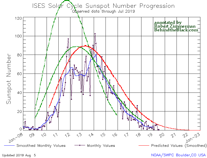
The monthly NOAA update of the solar cycle, covering sunspot activity for October 2018, was released yesterday. As I have done every month since this website began in July 2011, I am posting it below, annotated to give it some context.

Though there was a tiny uptick in sunspot activity on the Sun in October, the uptick was inconsequential. Overall, the activity in the past few months appears to closely match the weak activity seen in late 2007 and early 2008, just when the last solar minimum began.

October 2018 sunspot activity

The graph above has been modified to show the predictions of the solar science community. The green curves show the community’s two original predictions from April 2007, with half the scientists predicting a very strong maximum and half predicting a weak one. The red curve is their revised May 2009 prediction.

As I noted in August, the NOAA graph is now getting very close to its right edge, which ends in December 2018. They will very soon have to update this graph so that it can take us into the next solar cycle. While they must do this, it will unfortunately end the standard visual used by them for more than a decade for showing the progress of the solar cycle. Depending on how they change it, I might be able adapt it to include this graph to allow a continuation of the same visual into the future. We will have to see.

Having seen now the full solar maximum for this cycle (weak and short), we are now moving to the next question: Will the developing solar minimum be as long and as deep as the last? Will it evolve into a grand minimum, lasting decades, as some solar scientists believe?

Or will the Sun return to the higher levels of activity seen during most of the 24 solar cycles observed since the last grand minimum in the 1600s?

Since our understanding of these changes is very poor, your guess is likely as good as anyone else’s. All we can really do is keep our eyes open and watch what happens.

Danish astronomers question gravitational wave detection

The uncertainty of science: A team of Danish astronomers have questioned the gravitational wave detection achieved in the past few years by the LIGO gravitational wave telescopes.

The details are complex and very much in dispute, and the position of these Danish astronomers is very much in the minority, but their doubts have not been dismissed, and illustrate well the best aspects science. The article also outlines how the physics community and the LIGO scientists have welcomed the skepticism, even as they have doubts about the claims of the Danish astronomers. This is the hallmark of good science, and lends weight to the work at LIGO.

Dawn’s last look at Ceres

Ceres

The Dawn mission has ended, and the image on the right, reduced to post here, is one of its last views of Ceres, with the bright spots of Occator Crater clearly visible, before its fuel ran out. You can see the full resolution image by clicking on the image.

This photo of Ceres and the bright regions in Occator Crater was one of the last views NASA’s Dawn spacecraft transmitted before it depleted its remaining hydrazine and completed its mission.

This view, which faces south, was captured on Sept. 1, 2018 at an altitude of 2,340 miles (3,370 kilometers) as the spacecraft was ascending in its elliptical orbit. At its lowest point, the orbit dipped down to only about 22 miles (35 kilometers), which allowed Dawn to acquire very high-resolution images in this final phase of its mission. Some of the close-up images of Occator Crater are shown here.

Occator Crater is 57 miles (92 kilometers) across and 2.5 miles (4 kilometers) deep and holds the brightest area on Ceres, Cerealia Facula in its center and Vinalia Faculae in its western side. This region has been the subject of intense interest since Dawn’s approach to the dwarf planet in early 2015.

If NASA made any specific announcement about the end of the mission, I have missed it. Either way, this end is not a surprise, because they have made it clear for the past few months that the spacecraft was about to run out of fuel.

They have also posted today an image of Ceres’ largest mountain, Ahuna Mons.

Update: Even as I posted this, NASA sent out this press release: NASA’s Dawn mission comes to an end

OSIRIS-REx snaps image of target asteroid Bennu

Bennu

OSIRIS-REx has snapped its sharpest image yet of its target asteroid Bennu, set for a rendezvous on December 3. The image on the right is that image, at full resolution but cropped.

This “super-resolution” view of asteroid Bennu was created using eight images obtained by NASA’s OSIRIS-REx spacecraft on Oct. 29, 2018 from a distance of about 205 miles (330 km). The spacecraft was moving as it captured the images with the PolyCam camera, and Bennu rotated 1.2 degrees during the nearly one minute that elapsed between the first and the last snapshot. The team used a super-resolution algorithm to combine the eight images and produce a higher resolution view of the asteroid. Bennu occupies about 100 pixels and is oriented with its north pole at the top of the image.

It is beginning to appear that the OSIRIS-REx engineering team is going to have the same kind of problems now faced by the Hayabusa-2 engineering team. In this first glance Bennu appears very similar to Ryugu, a rubble pile shaped approximately like a box, rotating on one point. If so, they are also going to find it difficult to locate a smooth landing site.

Bennu by the way is in an orbit that makes a collision with the Earth possible in the late 22nd century. Knowing its composition, density, and solidity is critical for determining what to do, should that collision become likely.

Parker begins first perihelion fly-by of Sun

It’s getting hot in here: The Parker Solar Probe has begun its first close orbital fly-by of the Sun, set to last from now until November 11.

This solar encounter encompasses the first perihelion of the mission, the point at which Parker Solar Probe is closest to the Sun. Perihelion is expected at about 10:28 p.m. EST on Nov. 5. The spacecraft will come within 15 million miles of the Sun’s surface and clock in at a top speed of 213,200 miles per hour relative to the Sun — setting new records for both closest solar approach and top heliocentric speed by a spacecraft. At perihelion, Parker Solar Probe will fly through material at about 3.6 million degrees Fahrenheit — but because material in this region is so tenuous, it doesn’t influence the temperature of the spacecraft. However, the Sun’s intense radiation heats the Sun-facing side of the spacecraft’s heat shield, called the Thermal Protection System, to about 820 F.

For several days around the Nov. 5 perihelion, Parker Solar Probe will be completely out of contact with Earth because of interference from the Sun’s overwhelming radio emissions.

The article provides some nice details about the spacecraft’s design.

The vast northern plains of Mars

The vast northern plains of Mars

Cool image time! Actually, this image, found in the October image release from the high resolution camera of Mars Reconnaissance Orbiter (MRO), is not that interesting, in its own right. Context is all!

The image on the right is a small section cropped and reduced in resolution from the full image, which you can see by clicking on it. It shows one of the only interesting features in this long image strip, a small mesa sticking out all by itself in a flat featureless plain pockmarked by various small craters.

The release has no caption, though it is entitled “Northern Plains Survey.” The northern plains, while having a lot of interesting features that attract the attention of planetary scientists and thus get photographed at high resolution, is mostly featureless, at least at the resolution of the wide field survey cameras on many Mars orbiters. In order to know what is really there, they need to take high resolution images systematically, of which this image is obviously a part.

Overview image

The problem is that there is so much ground to cover. This particular image was taken of a spot in the middle of the plains just to the north of the drainage outlets from Valles Marineris, as shown by the context map to the right. The tiny white spot to the right in the middle of the blue plains north of those drainage outlets is the location of this image.

Detail area of overview map

To understand how much ground needs to be covered, to the right is a close-up of the area shown by the white box in the first image above, with red rectangles indicating where MRO has already taken images. The white cross is the subject image. As you can see, most of this immense plain has not yet been imaged. It is almost as if they threw a dart to pick this one location. Most everything around it remains unseen at high resolution. Thus, to understand the geology of this one image is hampered because the surrounding terrain remains unknown, in close detail.

Mars is a big place. It is an entire planet, with the same land surface as the Earth’s continents. It still contains many mysteries and unexplored places. It will take generations to see it all.

Early Milky Way collision uncovered by Gaia

Data from the space telescope Gaia has revealed a Milky Way merger event that occurred about 10 billion years ago.

Using the first 22 months of observations, a team of astronomers led by Amina Helmi, University of Groningen, The Netherlands, looked at seven million stars – those for which the full 3D positions and velocities are available – and found that some 30,000 of them were part of an ‘odd collection’ moving through the Milky Way. The observed stars in particular are currently passing by our solar neighbourhood.

We are so deeply embedded in this collection that its stars surround us almost completely, and so can be seen across most of the sky.

Even though they are interspersed with other stars, the stars in the collection stood out in the Gaia data because they all move along elongated trajectories in the opposite direction to the majority of the Galaxy’s other hundred billion stars, including the Sun. They also stood out in the so-called Hertzprung-Russell diagram – which is used to compare the colour and brightness of stars – indicating that they belong to a clearly distinct stellar population.

The sheer number of odd-moving stars involved intrigued Amina and her colleagues, who suspected they might have something to do with the Milky Way’s formation history and set to work to understand their origins. In the past, Amina and her research group had used computer simulations to study what happens to stars when two large galaxies merge. When she compared those to the Gaia data, the simulated results matched the observations. “The collection of stars we found with Gaia has all the properties of what you would expect from the debris of a galactic merger,” says Amina, lead author of the paper published today in Nature.

At the time, the two galaxies were both probably about the same size, approximately equivalent to the Magellanic Clouds.

Must I mention that there is some uncertainty here? The data is good, and the conclusions seem quite reasonable. At the same time, the data is still somewhat thin. We need a lot more Gaia-type telescopes mapping out the motions and positions of all the stars of the Milky Way in far more detail before the uncertainties here will shrink.

Timelapse movie of Supernova 1987A’s evolution from 1992 to 2017

Cool movie time! An astronomy graduate student in Toronto has created a movie showing the steady evolution of the shock wave from Supernova 1987A, the first supernova visible to the naked eye since the discovery of the telescope, during the past twenty-five years.

Yvette Cendes, a graduate student with the University of Toronto and the Leiden Observatory, has created a time-lapse showing the aftermath of the supernova over a 25-year period, from 1992 to 2017. The images show the shockwave expanding outward and slamming into debris that ringed the original star before its demise.

In an accompanying paper, published in the Astrophysical Journal on October 31st, Cendes and her colleagues add to the evidence that the expanding remnant is shaped—not like a ring like those of Saturn’s—but like a donut, a form known as a torus. They also confirm that the shockwave has now picked up some one thousand kilometres per second in speed. The acceleration has occurred because the expanding torus has punched through the ring of debris.

The animation, which I have embedded below the fold, uses images produced by an array radio telescopes in Australia.
» Read more

Oblique view of Hayabusa-2’s most recent landing rehearsal

Cool movie time! The Hayabusa-2 science team has released a small movie of images taken by a side-mounted camera of the spacecraft’s most recent landing rehearsal, showing the spacecraft ascend from its closest approach from an oblique angle.

I have embedded the movie from these images below the fold. As they note,

Images taken with the small monitor camera (CAM-H) during the Touchdown 1 Rehearsal 3 operation (TD1-R3). One image was captured every second from immediately after the spacecraft began to ascend (altitude 21m) on October 25, 2018 at 11:47 JST. The spacecraft was rising at about 52cm/s.

It appears the closest image was taken from about 21 meters away, about 65 feet, and gives a sense of scale. It also reveals once again how difficult that landing in January is going to be. Though this location is thought to be the smoothest spot on Ryugu, it is still littered with rocks that could cause problems.
» Read more

NASA decides to continue to ping Opportunity

NASA has decided to continue through January its effort to both listen and send signals to Opportunity in the hope of bringing it to life.

The 45-day deadline passed late last week. But NASA will continue active listening — a strategy that involves both sending commands to Opportunity and listening for any peeps the six-wheeled robot may make — for several more months at least, agency officials announced yesterday. “After a review of the progress of the listening campaign, NASA will continue its current strategy for attempting to make contact with the Opportunity rover for the foreseeable future,” NASA officials wrote in a mission update yesterday. “Winds could increase in the next few months at Opportunity’s location on Mars, resulting in dust being blown off the rover’s solar panels,” they added. “The agency will reassess the situation in the January 2019 time frame.”

This is exactly what the planetary scientists wanted. Their hope is that, with the beginning of dust devil season in November, the chances will then increase for removing the dust that likely covers the rover’s solar panels. It is thought that the rover has a better shot at coming back to life during this time period.

NASA officially retires Kepler

NASA today officially retired Kepler after nine years of operations.

After nine years in deep space collecting data that indicate our sky to be filled with billions of hidden planets – more planets even than stars – NASA’s Kepler space telescope has run out of fuel needed for further science operations. NASA has decided to retire the spacecraft within its current, safe orbit, away from Earth. Kepler leaves a legacy of more than 2,600 planet discoveries from outside our solar system, many of which could be promising places for life.

Exoplanet hunting however does not end here. Unlike Hubble, astronomers and NASA planned ahead for Kepler’s demise, and this year launched TESS to continue its work, in an even more sophisticated manner.

The steep slumping wall of a Martian volcano caldera

Caldera wall

Cool image time. The Mars Reconnaissance Orbiter science team today released a nice captioned image of the steep wall of the caldera of Ascraeus Mons, the northernmost of the three giant volcanoes that lie to the east of Olympus Mons, the biggest volcano of all. The image on the right, reduced and cropped, shows that steep wall, with full image available by clicking on it. The caption from the release focuses on the fluted upper parts of the wall.

We can see chutes carved into the soft dust that has built up on the slope, with some similarities to gully landforms elsewhere on the planet.

More revealing to me is how this image reveals the slumping that is slowing eroding the caldera’s walls while also making that caldera larger. First, the plateau above the cliff shows multiple small cliffs and pit chains, all more or less parallel to the wall. This suggests that the plateau is over time breaking apart and falling into that caldera. Think of it as an avalanche in slow motion, with the upper plateau separating into chunks as sections slowly tilt down toward eventual collapse. As these chunks separate, they cause cracks to form in that plateau, and hence the parallel cliffs and strings of pits.

On the floor of the caldera we can see evidence of past chunks that did fall, piled up in a series terraces at the base of the wall. These are covered with the soft dust that dominates Martian geology. That soft dust also apparently comprises much of the wall’s materials, and almost acts like a liquid as it periodically flows down the wall, producing the chutes at the top of the wall.

The weak Martian gravity here is an important factor that we on Earth have difficulty understanding. It allows for a much steeper terrain, that also allows structurally weaker materials to hold together that would be impossible on Earth.This image gives a taste of this alien geology, on a large scale.

Parker sets new records in its flight to the Sun

The Parker Solar Probe has set two new space records, first for making the closest approach to the Sun as well as becoming the fastest spacecraft ever.

The spacecraft passed the current record of 26.55 million miles from the Sun’s surface on Oct. 29, 2018, at about 1:04 p.m. EDT, as calculated by the Parker Solar Probe team. The previous record for closest solar approach was set by the German-American Helios 2 spacecraft in April 1976. As the Parker Solar Probe mission progresses, the spacecraft will repeatedly break its own records, with a final close approach of 3.83 million miles from the Sun’s surface expected in 2024.

“It’s been just 78 days since Parker Solar Probe launched, and we’ve now come closer to our star than any other spacecraft in history,” said Project Manager Andy Driesman, from the Johns Hopkins Applied Physics Laboratory in Laurel, Maryland. “It’s a proud moment for the team, though we remain focused on our first solar encounter, which begins on Oct. 31.”

Parker Solar Probe is also expected to break the record for fastest spacecraft traveling relative to the Sun on Oct. 29 at about 10:54 p.m. EDT. The current record for heliocentric speed is 153,454 miles per hour, set by Helios 2 in April 1976.

We ain’t seen nothin’ yet. This is only the first orbit. With each later orbit the spacecraft will zip past the Sun faster, and closer.

IAU once again sticks it to an American scientist, devaluing Edwin Hubble

In what is already seen by many scientists as an inappropriate action, the International Astronomical Union (IAU) this week voted to change the name of Hubble’s Law to the Hubble-Lemaître Law.

Hubble’s Law, a cornerstone of cosmology that describes the expanding universe, should now be called the Hubble-Lemaître Law, following a vote by the members of the International Astronomical Union (IAU), the same organization that revoked Pluto’s status as a planet. The change is designed to redress the historical neglect of Georges Lemaître, a Belgian astronomer and priest who in 1927 discovered the expanding universe—which also suggests a big bang. Lemaître published his ideas 2 years before U.S. astronomer Edwin Hubble described his observations that galaxies farther from the Milky Way recede faster.

There are so many things about this that are wrong it is hard to keep count. First, the IAU was never given the right to change the name of a scientific concept. It’s original job was merely to systemize the naming of astronomical objects, and that alone.

Second, it appears to be based on a misunderstanding of basic science.

The resolution has also come under fire for confusing two different issues: the expansion of the universe and the distance-velocity relation for galaxies, which is also known as the Hubble constant. Hubble never claimed to have discovered cosmic expansion, but did do much of observing work to nail down how fast the universe was expanding. “If the law is about the empirical relationship, it should be Hubble’s Law,” Kragh says. “If it is about cosmic expansion, it should be Lemaître’s Law.”

Third, it relies on bad history.

The text of the IAU resolution, circulated to members ahead of the vote, asserts that Hubble and Lemaître met in 1928, at an IAU general assembly in Leiden, the Netherlands—between the publication of their two papers—and “exchanged views” about the blockbuster theory. Kragh says that meeting “almost certainly didn’t take place” and that IAU’s statement “has no foundation in documented history.”

There are other problems, including the method by which the IAU conducted its vote. The bottom line is that this organization has no business sticking its nose into this issue, and it illustrates again, as happened when it tried to push a bad definition of “planets” on the planetary community in order to devalue the discovery of Pluto by an American, that there is a strong anti-American streak within it.

Scientists calculate Mars methane release

A new model describing how warmer weather could cause the seasonal spikes of methane on Mars matches the data from Curiosity in Gale Crater.

Moores and his colleagues analysed how methane might seep upwards through cracks and fissures in the Martian soil until it enters the atmosphere. Warming the soil could allow the gas to leak into the air, their calculations show. Seasons on Mars are complex, especially at Curiosity’s location so close to the planet’s equator. But the highest methane levels do appear just after the warmest time of the year, suggesting that heat spreading downward allows more of the gas to be released.

The amount of gas that the scientists estimate is entering the atmosphere is a good match for the measurements Curiosity has made at Gale crater, Moores told the American Astronomical Society’s Division for Planetary Sciences meeting in Knoxville, Tennessee. The methane’s ultimate source is still a mystery. But the work could help to explain the gas’s seasonal ebb and flow, he said. [emphasis mine]

The highlighted sentence is the most important. All they have done is found that they can model the pattern of seasonal release. They still have no idea whether the methane comes from a geological or biological source, which is of course the real question.

Fast radio bursts not detected at certain radio wavelengths

In observations by two different radio telescopes operating at different radio wavelengths but looking at the same part of the sky, astronomers have found that an observed fast radio burst was not detected by one of those telescopes.

The Curtin University-led Murchison Widefield Array (MWA) and CSIRO’s Australian SKA Pathfinder (ASKAP) telescopes were searching the sky for fast radio bursts, which are exceptionally bright flashes of energy coming from deep space. These extreme events last for only a millisecond but are so bright that many astronomers initially dismissed the first recorded fast radio burst as an observational error.

In research published in the Astrophysical Journal Letters, astronomers describe how ASKAP detected several extremely bright fast radio bursts, but the MWA—which scans the sky at lower frequencies—did not see anything, even though it was pointed at the same area of sky at the same time.

Lead author Dr Marcin Sokolowski, from the Curtin University node of the International Centre for Radio Astronomy Research (ICRAR), said the fact that the fast radio bursts were not observed at lower frequencies was highly significant. “When ASKAP sees these extremely bright events and the MWA doesn’t, that tells us something really unexpected is going on; either fast radio burst sources don’t emit at low frequencies, or the signals are blocked on their way to Earth,” Dr Sokolowski said.

If blocked at these lower frequencies, this tells theorists something about the environment where the burst occurred. If instead the burst does not emit in those lower frequencies, it tells them something about the burst itself.

Number of candidate exo-Earths reduced by Gaia data

Worlds without end: The number of candidate exo-Earths identified by Kepler has now been reduced based on data from Europe’s Gaia telescope.

To date, NASA’s prolific Kepler space telescope has discovered about 30 roughly Earth-size exoplanets in their host stars’ “habitable zone” — the range of orbital distances at which liquid water can likely exist on a world’s surface.

Or so researchers had thought. New observations by the European Space Agency’s (ESA) Gaia spacecraft suggest that the actual number is probably significantly smaller — perhaps between two and 12, NASA officials said today.

Gaia launched in December of 2013 to create an ultraprecise 3D map of the Milky Way. So far, this map includes position information for about 1.7 billion stars and distance data for about 1.3 billion stars, according to NASA officials. Gaia’s observations suggest that some of the Kepler host stars are brighter and bigger than previously believed, the officials added. Planets orbiting such stars are therefore likely larger and hotter than previously thought.

Being hotter and larger, the habitable zone for these stars shifts outward, placing the exoEarth’s outside the habitable zone.

Hubble resumes science operations

After three weeks of successful trouble-shooting of a backup gyroscope scientists have now returned the Hubble Space Telescope to full science operations.

Everyone should understand that this situation is now very temporary. Hubble no longer has any backup gyroscopes. If another fails, they will have to go to a one-gyroscope mode, holding the second working gyroscope back as a back-up, in order to extend the telescope’s life as much as possilbe. In that mode the telescope can operate for a significant period, but will have limited capabilities.

Hayabusa-2’s highest resolution image so far

Ryugu up close

The Hayabusa-2 science team has released the highest resolution image taken by the spacecraft so far. The image on the right, reduced to post here, is that image. Click on it to see the full resolution version.

The image resolution is about 4.6mm/pixel. This is the highest resolution image that Hayabusa2 has taken so far and even small rocks with a diameter of 2 – 3cm are clearly visible. The maximum resolution of AMICA –the camera at the time of the first Hayabusa mission— was 6 mm/pixel, so even its resolution has now been exceeded. As the image captured of the asteroid surface from the spacecraft, it will be one of the highest resolution to be taken of Ryugu (MINERVA-II1 and MASCOT which landed on the surface, have captured even higher resolution images).

A feature from the image is the lack of regolith (sandy substance). This was suspected to be true from the images obtained so far, but it is more clearly seen in this high resolution photograph. There is also a collection of pebbles with different colors, which may be evidence that the surface material of Ryugu is mixed.

This was taken during the second landing rehearsal about two weeks ago. The image clearly shows the rubble pile that is Ryugu, lacking anything but cemented rocks. It also illustrates the landing problem faced by Hayabusa-2’s engineers. They need a flat smooth area to land, and they have not really found one that fits their needs.

Intriguing water-ice cloud on Mars

Water-ice cloud over Arsia Mons

An extended water-ice cloud has formed recently on the downwind side of the large Martian volcano Arsia Mons. The image above, cropped to post here, was taken by Europe’s Mars Express orbiter, and shows the cloud extending westward from the volcano.

In spite of its location, this atmospheric feature is not linked to volcanic activity but is rather a water ice cloud driven by the influence of the volcano’s leeward slope on the air flow – something that scientists call an orographic or lee cloud – and a regular phenomenon in this region.

The cloud can be seen in this view taken on 10 October by the Visual Monitoring Camera (VMC) on Mars Express – which has imaged it hundreds of times over the past few weeks – as the white, elongated feature extending 1500 km westward of Arsia Mons. As a comparison, the cone-shaped volcano has a diameter of about 250 km.

… Mars just experienced its northern hemisphere winter solstice on 16 October. In the months leading up to the solstice, most cloud activity disappears over big volcanoes like Arsia Mons; its summit is covered with clouds throughout the rest of the martian year.

However, a seasonally recurrent water ice cloud, like the one shown in this image, is known to form along the southwest flank of this volcano – it was previously observed by Mars Express and other missions in 2009, 2012 and 2015.

What the article does not mention about these seasonal water ice clouds is that they are thought to be related to the evidence of past glaciers on the volcano’s western slopes. Some scientists believe that significant underground ice, left over from those glaciers, is what causes the clouds.

Astronomers confirm Earth has satellite dust clouds

Astronomers have confirmed the existence of two satellite dust clouds at the Earth’s L4 and L5 Lagrange points 250 thousand miles away, first spotted back in the 1960s.

The images they obtained show polarised light reflected from dust, extending well outside the field of view of the camera lens. The observed pattern matches predictions made by the same group of researchers in an earlier paper and is consistent with the earliest observations of the Kordylewski clouds six decades ago. Horváth’s group were able to rule out optical artefacts and other effects, meaning that the presence of the dust cloud is confirmed.

Since these locations are potential space station locations, determining the existence and nature of these dust clouds is important.

Changes on the slopes of Olympus Mons?

Dark splotches on slopes of Olympus Mons

Cool image time! In reviewing the many images from the October image release from the high resolution camera on Mars Reconnaissance Orbiter (MRO), I came across two images, here and here, labeled “Change Detection in Olympus Maculae.” The image on the right is a cropped and reduced section of the first image, centered on the area of most interest. If you click on the image you can see the full photograph.

I did some research to see if I could find the changes indicated by this title. The location is an area on the outer western slopes of Olympus Mons, the largest volcano in the solar system. I found that MRO has taken images of this location twice before, in 2007, in 2009. I spent about fifteen minutes trying to find something that had changed, but was unable to locate anything, other than what look like a few wind-blown streaks probably caused by dust devils. I suspect I do not know what to look for.

Maybe my readers can spend some time and find these changes. If you do, please let us know in a comment.

Nonetheless, these two images revealed an area on the slopes of Olympus Mons that is most intriguing. It appears that there is a whole string of these dark splotches in this area, all of which have been carefully imaged by MRO several times. These splotches, along with the image titles, suggest that this might be area where there is activity from below that is causing the surface to darken. Could it be volcanic? Not likely. More likely is that there is underground frozen water located here, and like the spiders at the poles, this ice periodically pushes up as it sublimates to burst out as gas, and in the process darkens the surface.

If this guess on my part is correct, it suggests that this is an area in the mid-latitudes of Mars where water might be reasonably accessible. For future settlers this would be a significant discovery. And if my guess is wrong no matter. The features are puzzling, which explains why the scientists are aiming MRO at them repeatedly.

If I was to writing my science fiction novel Pioneer today, this is where I would have placed the discovery of the body of the Sanford Addiono, the astronaut who had disappeared on an asteroid near the orbit of Jupiter forty-six years previously. As the press release for the book’s release noted,

How Addiono had gotten to Mars from a distant lost asteroid–without a spaceship–was baffling.

That riddle was magnified by what Addiono had brought back with him. Among his effects was a six-fingered robot hand that had clearly been made by some alien civilization, along with a recorder and memo book describing what Addiono had seen.

What better place to put the start of this mystery but here, on a dark splotch on the slopes of Olympus Mons that also indicates its own geological mystery, a place some underground activity might be reshaping the surface of Mars.

1 120 121 122 123 124 277