
Mapping daylight at the Moon’s South Pole
Using data from the Japanese lunar orbiter Kaguya, scientists have identified several locations near the Moon’s south pole that are in daylight from 86 to 94 percent of the time. Key quote from abstract:
The place receiving the most illumination (86% of the year) is located close to the rim of Shackleton crater at 88.74°S 124.5°E. However two other areas, less than 10 km apart from each other, are collectively lit for 94% of the year. We found that sites exist near the south pole that are continuously lit for several months during summer. We were also able to map the locations and durations of eclipse periods for these areas. Finally we analyzed the seasonal variations in lighting conditions, from summer to winter, for key areas near the south pole. We conclude that areas exist near the south pole that have illumination conditions that make them ideal candidates as future outpost sites. [emphasis mine]
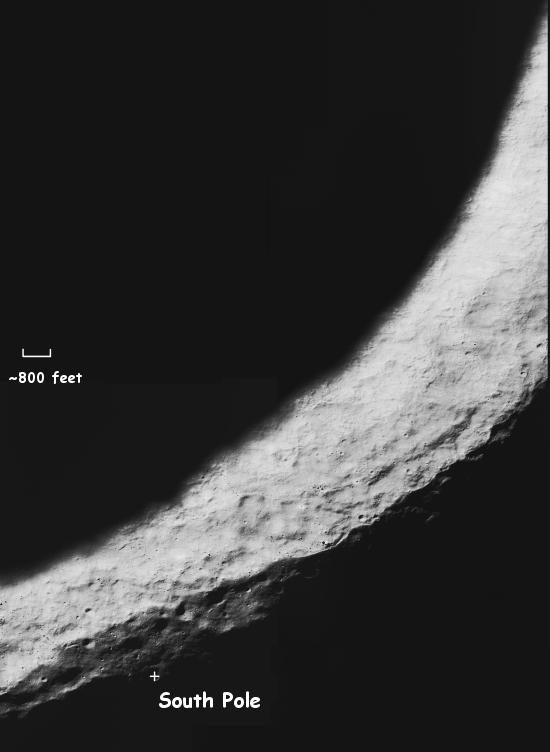
Below is a composite close-up image of the rim of Shackleten crator that I assembled using this Lunar Reconnaissance image. The key quote from the full caption :
The full [Narrow Angle Camera] mosaic reveals a shelf on the southeast flank of the crater that is more than two kilometers across and perfectly suitable for a future landing. The extreme Sun angle gives the surface an exaggerated rough appearance, but if you look closely at this scale any area that is between the small craters might make a good landing site.

On Christmas Eve 1968 three Americans became the first humans to visit another world. What they did to celebrate was unexpected and profound, and will be remembered throughout all human history. Genesis: the Story of Apollo 8, Robert Zimmerman's classic history of humanity's first journey to another world, tells that story, and it is now available as both an ebook and an audiobook, both with a foreword by Valerie Anders and a new introduction by Robert Zimmerman.
The print edition can be purchased at Amazon or from any other book seller. If you want an autographed copy the price is $60 for the hardback and $45 for the paperback, plus $8 shipping for each. Go here for purchasing details. The ebook is available everywhere for $5.99 (before discount) at amazon, or direct from my ebook publisher, ebookit. If you buy it from ebookit you don't support the big tech companies and the author gets a bigger cut much sooner.
The audiobook is also available at all these vendors, and is also free with a 30-day trial membership to Audible.
"Not simply about one mission, [Genesis] is also the history of America's quest for the moon... Zimmerman has done a masterful job of tying disparate events together into a solid account of one of America's greatest human triumphs."--San Antonio Express-News
We have a great deal of laser data from Kaguya and its still coming from LRO. I agree that these data can be helpful to identify outpost sites. However, I have a few issues with the laser data I would like addressed.
1). The drawback of any laser data is that the laser lights only paints a small fraction of the lunar surface area (<0.2%). This is my estimate based on their stated 1 laser shot per second frequency, operating for 2 years, and a 20 m radius laser beam at the lunar surface. Thus,
Total number of laser shots= 365 days/year *2 years operation * 24 hours/day * 60 minutes/hour * 60 seconds/minute =63 million laser shots.
Area painted by laser light= 63 million laser shots * PI * (20 meter radius/laser shot / 1000 meter/kilometer) ^2=~79000 square kilometers
Moon's surface area=4*PI*(1737 km Moon radius)^2=~38 million square kilometers
Percentage of lunar surface with altitude measured by laser light= 79000/38000000*(100 percentage/decimal fraction)=~0.2%
They then interpolate these sparse points to create digital maps at 500m/pixel. I don't know about you, but I am a little dubious of interpolating a 500 m by 500 m surface with only 0.2% of the area fully defined. What is needed is an error estimate for each of these maps points. I admit the polar regions have somewhat better coverage/laser point density because of the orbit crossing the poles, but it is not that much more (likely <1%).
Although laser data gives a general idea of the illumination situation, it is very hard to be accurate (except for a particular point and illumination analysis requires entire large areas). What if the laser measured the low point (or high point) in that 500 m by 500 m area rather than an average point?
What was needed was a terrain map based on the combined laser data and stereo-imagery derived data, of which JAXA apparently did some work on.
2). I am a little concerned about placing an outpost right where the light is best since it may be hard to drive up to the high points. The outpost may be better a little lower down and cables run to the better illuminated spots.
3). I am concerned about how much Kaguya data they used to generate the results. Earlier papers they wrote on the subject (http://www.lpi.usra.edu/meetings/lpsc2010/pdf/2293.pdf) implied they used a terrain model from 85 deg to 90 deg south. But the problem is that there may be shadow casting terrain (for very low Sun angles during lunar Winter) beyond that.
4). In comparing with actual Clementine images, it is fortuitous they could get a match given the uncertainty of the surface slopes due to the interpolations mentioned in (1). For shallow sun angles, the angle of the lunar surface with respect tot he Sun affects its brightness considerably. Even given a perfect digital elevation model, the method of generating polygonal surfaces from point data is arbitrary.
In summary, the identified sites were very good, but more work is needed to confirm the results. This can be done partly with LRO LOLA laser data and mainly with stereo-imagery derived altimetry (and we have a slew of images from LRO to do this).