New Horizons data suggests the Kuiper Belt is emptier that previously believed

The uncertainty of science: An analysis of data from New Horizons now suggests a paucity of small objects in the Kuiper Belt.

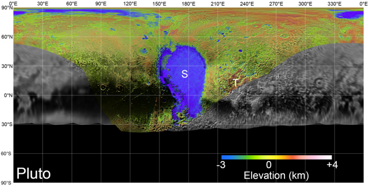
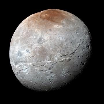
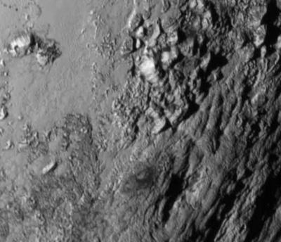
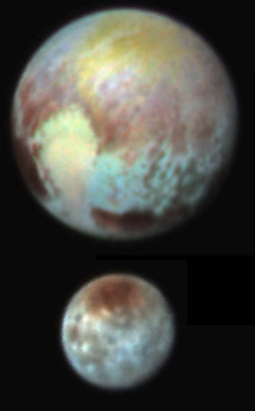
Using New Horizons data from the Pluto-Charon flyby in 2015, a Southwest Research Institute-led team of scientists have indirectly discovered a distinct and surprising lack of very small objects in the Kuiper Belt. The evidence for the paucity of small Kuiper Belt objects (KBOs) comes from New Horizons imaging that revealed a dearth of small craters on Pluto’s largest satellite, Charon, indicating that impactors from 300 feet to 1 mile (91 meters to 1.6 km) in diameter must also be rare.

I therefore wonder how the objects we do find there formed. The volume of space in the Kuiper Belt is gigantic, and if the larger bodies found so far are the bulk of the objects there, what did they coalesce from? Moreover, it seems unlikely that the few large objects we have found there would have been able to clear the region out of small objects.

Overall, this is a fundamental mystery tied directly to how the solar system formed, and illustrates how little we know about that process.

IAU approves China’s proposed names for Chang’e-4 landing site

That was fast! The International Astronomical Union (IAU) has approved all of the proposed names that China submitted for the features at or near Chang’e-4 landing site.

The IAU Working Group for Planetary System Nomenclature has approved the name Statio Tianhe for the landing site where the Chinese spacecraft Chang’e-4 touched down on 3 January this year, in the first-ever landing on the far side of the Moon. The name Tianhe originates from the ancient Chinese name for the Milky Way, which was the sky river that separated Niulang and Zhinyu in the folk tale “The Cowherd and the Weaver Girl”.

Four other names for features near the landing site have also been approved. In keeping with the theme of the above-mentioned folk tale, three small craters that form a triangle around the landing site have been named Zhinyu, Hegu, and Tianjin, which correspond to characters in the tale. They are also names of ancient Chinese constellations from the time of the Han dynasty. The fifth approved name is Mons Tai, assigned to the central peak of the crater Von Kármán, in which the landing occurred. Mons Tai is named for Mount Tai, a mountain in Shandong, China, and is about 46 km to the northwest of the Chang’e-4 landing site.

Compare this fast action with the IAU’s approval process for the names the New Horizons team picked for both Pluto and Ultima Thule. It took the IAU more than two years to approve the Pluto names, and almost three years to approve the Charon names. It is now almost two months after New Horizons’ fly-by of Ultima Thule, and the IAU has not yet approved the team’s picks for that body.

Yet it is able to get China’s picks approved in less than a month? Though it is obviously possible that there is a simple and innocent explanation for the differences here, I think this illustrates well the biases of the IAU. Its membership does not like the United States, and works to stymie our achievements if it can. This factor played a part in the Pluto/planet fiasco. It played a part in its decision to rename Hubble’s Law. And according to my sources, it was part of the background negotiations in the naming of some lunar craters last year to honor the Apollo 8 astronauts.

The bottom line remains: The IAU has continually tried to expand its naming authority, when all it was originally asked to do was to coordinate the naming of distant astronomical objects. Now it claims it has the right to approve the naming of every boulder and rock anywhere in the universe. At some point the actual explorers are going to have to tell this organization to go jump in a lake.

True color images of Pluto and Charon

The New Horizons science team has released mosaic global images of Pluto and Charon, calibrated to capture their true colors as closely as possible.

These natural-color images result from refined calibrations of data gathered by New Horizons’ Multispectral Visible Imaging Camera (MVIC).”That processing creates images that would approximate the colors that the human eye would perceive – bringing them closer to ‘true color’ than the images released near the encounter,” said Alex Parker, a New Horizons science team co-investigator from Southwest Research Institute, Boulder, Colorado.

Because MVIC’s color filters don’t closely match the wavelengths sensed by human vision, mission scientists applied special processing to translate the raw MVIC data into an estimate of the colors that the eye would see. The colors are more subdued than those constructed from the raw MVIC color data, because of the narrower wavelength range sensed by the human eye.

Both images were taken as New Horizons zipped toward closest approach to Pluto and its moons on July 14, 2015; Charon was taken from a range of 46,091 miles (74,176 kilometers) and Pluto from 22,025 miles (35,445 kilometers). Each is a single color MVIC scan, with no data from other New Horizons imagers or instruments added. The striking features on each are clearly visible, from Charon’s reddish north-polar region known as Mordor Macula, to the bright expanse of Pluto’s, nitrogen-and-methane-ice rich “heart,” named Sputnik Planitia.

I must add that these images show only one hemisphere, since the New Horizons flyby did not get a good look at the opposite hemisphere. We won’t know what the other half of both planets look like for many decades.

Global topographic maps of Pluto and Charon

Using data and images from New Horizons scientists have now produced the first global topographic maps of Pluto and Charon.

Obviously, the resolution for the maps of both planets is very uneven, since the spacecraft only saw part of each planet at high resolution during its fly-by. Nonetheless, they note some of the more interesting details revealed:

These maps reveal a rich variety of landforms on both Pluto and Charon. The topographic maps confirm that the highest known mountains on Pluto are the Tenzing Montes range, which formed along the southwestern margins of the frozen nitrogen ice sheet of Sputnik Planitia. These steep-sided icy peaks have slopes of 40° or more and rise several kilometers above the floor of Sputnik Planitia. The highest peak rises approximately 6 kilometers (3.7 miles) above the base of the range, comparable to base-to-crest heights of Denali in Alaska, and Kilimanjaro in Kenya. Pluto’s mountains must be composed of stiff water ice in order to maintain their heights, as the more volatile ices observed on Pluto, including methane and nitrogen ice, would be too weak and the mountains would collapse.

The topographic maps also reveal large-scale features that are not obvious in the global mosaic map. The ice sheet within the 1000-kilometer (625-mile) wide Sputnik Planitia is on average 2.5 kilometers (1.5 miles) deep while the outer edges of the ice sheet lie an even deeper 3.5 km (or 2.2. miles) below Pluto’s mean elevation, or ‘sea level’ surface. While most of the ice sheet is relatively flat, these outer edges of Sputnik Planitia are the lowest known areas on Pluto, all features that are evident only in the stereo images and elevation maps. The topographic maps also reveal the existence of a global-scale deeply eroded ridge-and-trough system more than 3000 kilometers (or 1864 miles) long, trending from north-to-south near the western edge of Sputnik Planitia. This feature is the longest known on Pluto and indicates that extensive fracturing occurred in the distant past. Why such fracturing occurred only along this linear band is not well understood.

On Charon the topographic maps also reveal deep depressions near the north pole that are ~14 kilometers (8.7 miles) deep, deeper than the Marianas Trench on Earth. The equatorial troughs that form the boundary between the northern and southern plains on Charon also feature high relief of ~8 kilometers. The mapping of fractured northern terrains and tilted crustal blocks along this boundary could be due to cryovolcanic resurfacing, perhaps triggered by the foundering of large crustal blocks into the deep interior of Charon. The rugged relief also indicates that Charon retains much of its original topography caused by its history of fracturing and surface disruption.

These maps are obviously only our first stab at mapping both planets. We will need orbiters around both to truly detail their surface features.

A map of Pluto

Our best map of Pluto for many decades to come

The New Horizons science team has released the best maps of both Pluto and Charon possible from the images taken during the spacecraft’s fly-by of the ninth planet last year.

The new maps include global mosaics of Pluto and Charon, assembled from nearly all of the highest-resolution images obtained by New Horizons’ Long-Range Reconnaissance Imager (LORRI) and the Multispectral Visible Imaging Camera (MVIC). These mosaics are the most detailed and comprehensive global views yet of the Pluto and Charon surfaces using New Horizons data.

The new collection also includes topography maps of the hemispheres of Pluto and Charon visible to New Horizons during the spacecraft’s closest approach. The topography is derived from digital stereo-image mapping tools that measure the parallax – or the difference in the apparent relative positions – of features on the surface obtained at different viewing angles during the encounter. Scientists use these parallax displacements of high and low terrain to estimate landform heights.

You will also notice large areas of both Pluto and Charon that remain very fuzzy and unclear. What exactly is there will remain a mystery for many decades to come.

Landslides on Charon

Landslide on Charon

Images from New Horizons have detected evidence of past avalanches on Pluto’s largest moon, Charon. The image on the right is a reduced version of a perspective view created using data from various instruments.

This perspective view of Charon’s informally named “Serenity Chasm” consists of topography generated from stereo reconstruction of images taken by New Horizons’ Long Range Reconnaissance Imager (LORRI) and Multispectral Visible Imaging Camera (MVIC), supplemented by a “shape-from-shading” algorithm. The topography is then overlain with the PIA21128 image mosaic and the perspective view is rendered. The MVIC image was taken from a distance of 45,458 miles (73,159 kilometers) while the LORRI picture was taken from 19,511 miles (31,401 kilometers) away, both on July 14, 2015.

close-up of landslide

To the left is a close-up taken from the annotated image. You can see the slump materials at the base of the mountain left behind after the material slide down the mountain. It is not clear whether it is Charon’s lower gravity and alien composition and environment (very very very cold) that makes this look more muddy than one would expect, or whether it is because of the limited resolution of the original image and the modeling to create the oblique version.

Charon’s red polar region explained?

Scientists, using data from New Horizons as well as new computer models, think they have come up with an explanation for the red polar region of Pluto’s moon Charon.

As they detail this week in the international scientific journal Nature, Charon’s polar coloring comes from Pluto itself – as methane gas that escapes from Pluto’s atmosphere and becomes “trapped” by the moon’s gravity and freezes to the cold, icy surface at Charon’s pole. This is followed by chemical processing by ultraviolet light from the sun that transforms the methane into heavier hydrocarbons and eventually into reddish organic materials called tholins.

A frozen underground ocean on Charon?

Data from New Horizons of the surface of Pluto’s moon Charon now suggests that the satellite once had an underground ocean that is now frozen.

Charon’s outer layer is primarily water ice. When the moon was young this layer was warmed by the decay of radioactive elements, as well as Charon’s own internal heat of formation. Scientists say Charon could have been warm enough to cause the water ice to melt deep down, creating a subsurface ocean. But as Charon cooled over time, this ocean would have frozen and expanded (as happens when water freezes), pushing the surface outward and producing the massive chasms we see today.

Charon in color

Charon

The New Horizons science team has released new high resolution images of Pluto’s moon Charon, including the global enhanced color view on the right.

High-resolution images of the Pluto-facing hemisphere of Charon, taken by New Horizons as the spacecraft sped through the Pluto system on July 14, and transmitted to Earth on Sept. 21, reveal details of a belt of fractures and canyons just north of the moon’s equator. This great canyon system stretches across the entire face of Charon, more than a thousand miles, and probably around onto Charon’s far side. Four times as long as the Grand Canyon, and twice as deep in places, these faults and canyons indicate a titanic geological upheaval in Charon’s past. “It looks like the entire crust of Charon has been split open,” said John Spencer, deputy lead for GGI at the Southwest Research Institute in Boulder, Colorado. “In respect to its size relative to Charon, this feature is much like the vast Valles Marineris canyon system on Mars.”

The team has also discovered that the plains south of the canyon, informally referred to as Vulcan Planum, have fewer large craters than the regions to the north, indicating that they are noticeably younger. The smoothness of the plains, as well as their grooves and faint ridges, are clear signs of wide-scale resurfacing.

In many ways these images remind me of an upside-down Mars, with the smooth lower plains in the south instead of the north. Obviously, the causes on Charon are going to be significantly different than those on Mars.

Weird geology on Charon

Charon's mountain in a moat

As they await the arrival of more data from New Horizons, the science team have highlighted this interesting and entirely puzzling feature revealed in their first global image from Charon, shown in the image on the right, a mountain inside a depression. Note also the nearby rill-like depressions running from one crater to the next.

My first thought is that the mountain, which in this relatively low resolution image looks almost like a really gigantic boulder, is made of material denser than the ground in which it sits, and some heating event caused the ground to soften and collapse, dropping the mountain-sized boulder down into the sinkhole.

I am guessing of course. What we have here is a very alien environment, with geological processes in temperatures and densities and gravities to which we are wholly unfamiliar. What we would normally expect to happen is not something we should expect to normally happen on either Charon or Pluto.

First New Horizons fly-by images released

Ice mountains on Pluto

Many cool images! I will only post one, on the right, of the ice mountains seen at the southernmost edge of Tombauh Regio. More can be seen here.

Some quick facts revealed during today’s the press conference:

  • They have gotten good data on Pluto’s atmosphere. Earlier data just before fly-by suggested that there are specific regions on the surface that have a lot of methane, but with different properties depending on location.
  • They have found that the surface of Charon is active. It also looks like a weird Moon, cratered, with a dark mare region they have dubbed Mordor. Its cause however is not the same as the Moon. There are also a large sequence of troughs and cliffs that are unlike other planets. Some areas are very smooth, as they they have been repaved after cratering. And there is a canyon that is very very deep, 3 miles deep, that makes it relatively deeper than any other canyon in the solar system.
  • Pluto’s moon Hydra is not spherical, and in fact looks like an asteroid.
  • The white heart is now been named Tombaugh Regio after one of Pluto’s discoverers. In its southern extent there are mountains and strange pits. And this area has no impact craters, meaning this is a very young surface, less than 100 million years old. The mountains have to made of ice, which is essentially the only thing that can be bedrock at Pluto’s temperatures, based on what they think Pluto is composed of.
  • The data shows repeatedly that a tiny planet can still have geological activity after billions of years, even without a giant gas giant nearby to produce tidal heating.
  • They have named the giant whale-shaped dark region at the equator Cthulu Regio.

The data and images will be coming back from New Horizons for the next year, so the show is certainly not over.

Pluto and Charon in false color

Pluto and Charon in false color

While waiting for word about how New Horizons has fared during its close fly-by of Pluto, the science team today released the false color images on the right of both Pluto and Charon to illustrate the complicated surface geology of both planetary bodies.

The new color images reveal that the “heart” of Pluto actually consists of two remarkably different-colored regions. In the false-color image, the heart consists of a western lobe shaped like an ice cream cone that appears peach color in this image. A mottled area on the right (east) side looks bluish. A mid-latitude band appears in shades ranging from pale blue through red. Even within the northern polar cap, in the upper part of the image, various shades of yellow-orange indicate subtle compositional differences. This image was obtained using three of the color filters of the Ralph instrument on July 13 at 3:38 am EDT and received on the ground on at 12:25 pm.

The surface of Charon is viewed using the same exaggerated color. The red on the dark northern polar cap of Charon is attributed to hydrocarbon and other molecules, a class of chemical compounds called tholins. The mottled colors at lower latitudes point to the diversity of terrains on Charon. This image was obtained using three of the color filters of the Ralph instrument on July 13 at 3:38 am EDT and received on the ground on at 12:25 pm.

Word on the spacecraft’s status will arrive at around 9 pm (eastern) tonight. Images and data will then follow, assuming all is well.

Another new Pluto image

Pluto geology

Cool image time! The New Horizons science team released another image of Pluto on Friday, this time showing enough details that they can begin to see geological features.

New Horizons’ latest image of Pluto was taken on July 9, 2015 from 3.3 million miles (5.4 million kilometers) away, with a resolution of 17 miles (27 kilometers) per pixel. At this range, Pluto is beginning to reveal the first signs of discrete geologic features. This image views the side of Pluto that always faces its largest moon, Charon, and includes the so-called “tail” of the dark whale-shaped feature along its equator. (The immense, bright feature shaped like a heart had rotated from view when this image was captured.)

“Among the structures tentatively identified in this new image are what appear to be polygonal features; a complex band of terrain stretching east-northeast across the planet, approximately 1,000 miles long; and a complex region where bright terrains meet the dark terrains of the whale,” said New Horizons principal investigator Alan Stern.

Be sure to click on the link to see the full resolution version of the image.

New image of Pluto and Charon

Pluto and Charon

The New Horizons science team today released a new image showing both Pluto and Charon, and not unexpectedly, they are very different from each other.

A high-contrast array of bright and dark features covers Pluto’s surface, while on Charon, only a dark polar region interrupts a generally more uniform light gray terrain. The reddish materials that color Pluto are absent on Charon. Pluto has a significant atmosphere; Charon does not. On Pluto, exotic ices like frozen nitrogen, methane, and carbon monoxide have been found, while Charon’s surface is made of frozen water and ammonia compounds. The interior of Pluto is mostly rock, while Charon contains equal measures of rock and water ice. “These two objects have been together for billions of years, in the same orbit, but they are totally different,” said Principal Investigator Alan Stern of the Southwest Research Institute (SwRI), Boulder, Colorado.

For a half century, since the first probes left Earth to visit other worlds, the one consistent axiom we have learned from every mission is that no two objects are going to be alike, and that every object out there is going to be incredibly unique. Pluto and Charon, in finishing the human race’s first inventory of the solar system, prove this axiom once again.

New Horizons team proposes cool names for Charon and Pluto features

In anticipation of their discovering many previously unseen features on both Pluto and Charon, the New Horizons science team released today a proposed list of names, including “Kirk”, “Spock”, and many other fictional science fiction characters.

Many of these suggestions were proposed by the public. Personally, I prefer the part of their proposal where they suggest naming features after real people, like Lewis Carroll and Arthur Clarke.

New Horizons gets closer

Pluto and Charon

Cool image time! Even as the engineers successfully completed last night their last course correction engine burn, the New Horizons science team released an image showing both Pluto and Charon.

The 23-second thruster burst was the third and final planned targeting maneuver of New Horizons’ approach phase to Pluto; it was also the smallest of the nine course corrections since New Horizons launched in January 2006. It bumped the spacecraft’s velocity by just 27 centimeters per second – about one-half mile per hour – slightly adjusting its arrival time and position at a flyby close-approach target point approximately 7,750 miles (12,500 kilometers) above Pluto’s surface.

The image, which I have cropped to focus on the planets, is still somewhat fuzzy, though it also shows the increasing sharpness as the spacecraft gets closer.

Only two weeks to go!

Latest images from New Horizons see Pluto’s polar cap

Images taken between April 12 and April 18 by New Horizons of Pluto not only show one complete rotation of the planet as well as its moon Charon, the images also show a bright spot at Pluto’s pole that could be a polar cap.

The article calls it an “ice cap” but that is premature. At Pluto that cap could be made of a number of materials, not just water. We will not know until New Horizons gets closer.

Week long movie of Pluto produced by New Horizons

Cool images! Using New Horizons’ long range camera scientists have compiled a movie showing Charon and Pluto orbiting each other during the last week of January 2015.

Pluto and Charon were observed for an entire rotation of each body; a “day” on Pluto and Charon is 6.4 Earth days. The first of the images was taken when New Horizons was about 3 billion miles from Earth, but just 126 million miles (203 million kilometers) from Pluto—about 30% farther than Earth’s distance from the Sun. The last frame came 6½ days later, with New Horizons more than 5 million miles (8 million kilometers) closer.

The wobble easily visible in Pluto’s motion, as Charon orbits, is due to the gravity of Charon, about one-eighth as massive as Pluto and about the size of Texas.

Our view of Pluto, and Charon, is only going to get better as New Horizons zooms towards its July fly-by.

New Pluto images from New Horizons

Pluto from 126 million miles

The New Horizons science team has finally released the navigation image of Pluto and Charon that the spacecraft took on January 25.

A cropped version is on the right. The image shows Pluto and its biggest moon Charon, with both appearing somewhat elongated in shape. Why this is so is not explained by the press release, but I suspect it is because the goal of the image was not sharpness but to locate the planet for navigation purposes.