Cave pits in the Martian northern lowlands

I could call this my monthly Martian Pit update. Since November 2018 I have each month found from two to five new and interesting cave pits in the monthly download of new images from the high resolution camera on Mars Reconnaissance Orbiter (MRO). My previous posts:
- November 12, 2018
- January 30, 2019
- February 22, 2019
- April 2, 2019
- May 7, 2019
- July 1, 2019
- August 12, 2019
All except the last August 12 post were for pits on the flanks of Arsia Mons, the southernmost in the line of three giant volcanoes to the southeast of Olympus Mons, and were thus almost certainly resulting from lava flows.
The August 12 post instead showed pits found in Utopia Planitia, one of the large plains that comprise the Martian northern lowlands where scientists think an intermittent ocean might have once existed. All of these pits are found in a region of meandering canyons dubbed Hephaestus Fossae.
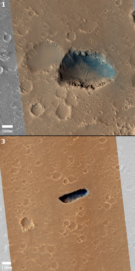
In the most recent MRO release scientists once again focused on the pits in or near Hephaetus, imaging four pits, two of which have been imaged previously, as shown in my August post and labeled #2 and #4 in this article, and two (here and here) that appear new. The image on the right, cropped to post here, shows the two new pits, dubbed #1 and #3. In the full image of #1, it is clear that this pit lines up nicely with some other less prominent depressions, suggesting an underground cave. Pit #3 however is more puzzling. In the full image, this pit actually runs perpendicular to a long depression to the west. There are also no other related features around it.
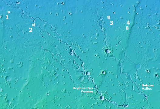
What makes all four of these pits intriguing is their relationship to Hephaestus Fossae and a neighboring rill-like canyon dubbed Hebrus Valles, as shown in the overview map below.

All the pits are found in the downstream end of both Hephaestus Fossae and Hebrus Valles. Note also that to the east of this overview is the giant volcano Elysium Mons, which means these canyons are flowing down from that volcano.
Scientists are not sure what caused these channels. Several have proposed that they could have been caused by catastrophic floods of water, melting because of heating from the volcano. Others suspect these rills are indications of lava flows coming down from Elysium Mons, forming lava tubes. In either case there appears no consensus.
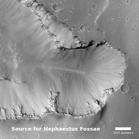
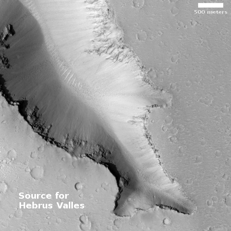
I could not help wondering what the southeastern sources of both these two rills looked like. Not surprisingly, the scientists were interested long before me, and have taken a bunch of high resolution MRO images of both.
To the right are sections of the most prominent sources of the two canyons, cropped and reduced to post here. As you can see, there are no obvious outlets coming from the uphill direction to the east. Then again, a lot of time has passed since any liquid water could have flowed here. In that time a lot of Martian dust has been deposited. Furthermore, you can see with both sources that a considerable amount of what looks like alluvial fill debris has fallen from the cliff walls, creating the long slopes down to the bottom. Any openings that might have once been here have certainly been long buried by these processes.
Because of the likelihood of water in this region, some scientists have proposed [pdf] this region as a prime exploration target, especially because of the possibility of caves.
One last interesting factoid. I could not help noticing that all four pits are at the same latitude, 21-21 degrees north. This places them south of the northern glacial band that exists from 30 to 60 degrees latitude. Thus, these pits could provide the answer to one of the fundamental questions scientists have about Mars: How far south does the ice table below the surface extend? It appears, based on the buried glaciers that have been identified, that this ice table gets as far south as 30 degrees. Whether it exists at 20 degrees north latitude however remains unknown.
My guess is that elevation would be a factor. At higher elevations, such as the flanks of the volcanoes, buried ice table would have more chance of existing at lower latitudes. In Utopia Planitia, however, the low elevation plus the low latitude would suggest that buried ice is unlikely.
We do not yet know this, however. These pits however might someday tell us.
On Christmas Eve 1968 three Americans became the first humans to visit another world. What they did to celebrate was unexpected and profound, and will be remembered throughout all human history. Genesis: the Story of Apollo 8, Robert Zimmerman's classic history of humanity's first journey to another world, tells that story, and it is now available as both an ebook and an audiobook, both with a foreword by Valerie Anders and a new introduction by Robert Zimmerman.
The print edition can be purchased at Amazon or from any other book seller. If you want an autographed copy the price is $60 for the hardback and $45 for the paperback, plus $8 shipping for each. Go here for purchasing details. The ebook is available everywhere for $5.99 (before discount) at amazon, or direct from my ebook publisher, ebookit. If you buy it from ebookit you don't support the big tech companies and the author gets a bigger cut much sooner.
The audiobook is also available at all these vendors, and is also free with a 30-day trial membership to Audible.
"Not simply about one mission, [Genesis] is also the history of America's quest for the moon... Zimmerman has done a masterful job of tying disparate events together into a solid account of one of America's greatest human triumphs."--San Antonio Express-News


pits yes
where the [deleted] caves
The first thought that came to mind when I saw the images was “sinkholes.” Then I read your narrative. I’m still thinking “sinkholes” and that goes with your thought on subterranean ice.
Roland L Wilt: The rules for commenting here are very clearly outlined on the webpage, right above the box listing the last ten comments. No obscenities or insults allowed. I have deleted such from your comment and are now issuing you a warning.
You are very welcome to comment here, but if you do it again you will be suspended for a week. Do it a third time and you will be banned.
George L: Sinkholes is actually quite correct. These very much suggest sinkholes with voids below. I was in a hurry to get the post up, and for some reason that word never occurred to me, even though I am a caver with much experience in sinkholes as well as digging open caves at their bottoms.
There is something fishy about the second image…. ;-)
But seriously Bob, having done a little caving myself, and as the son of a world class caver ( 50 years or so ago!), I understand that your curiosity must extend far beyond the practical uses for martian caves…. It is also fascinating to contemplate how the differences in air pressure and gravity will have effected cave evolution… And dare we consider water disolved spaces with deposited formations from desolved minerals? Bright red stalagmites anyone?
Fascinating!!
I prefer the term “cenote” to “sinkhole” due to the size we’re talking about, but I suppose that’s a Tomahto vs Tomayto distinction and will never be settled…