
The strange moated mesas of the Kasei Valley on Mars
In showing my readers today’s cool image, I want to present it as it is seen by scientists, first from a far distance that with time increasingly zooms in to reveal mysteries on a very human scale.
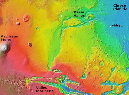
The overview map to the right essentially gives us the view of Mars as seen by scientists following the Mariner 9 orbiter mission that began mapping the Martian surface in late 1971 after the conclusion of a global dust storm that had hidden its surface initially. As the first high resolution map of Mars, the orbiter revealed numerous puzzling and surprising features, including the largest volcanoes and canyons in the solar system. The orbiter also found that the red planet’s surface was comprised of two very different regions, the northern lowland plains and the southern cratered highlands.
The overview map, covering from about 13 degrees south latitude to about 34 degrees north latitude, shows us all but the southern cratered highlands. The white box in Kasei Valles is where today’s cool image is located. Both Kasai and Valles Marineris represent those giant canyons, all invoking to Earth eyes the possibility of catastrophic floods of liquid water sometime in the past.
Ascraeus Mons is the northernmost of the three giant volcanoes east of the biggest volcano of all, Olympus Mons. All sit on what scientists now call the Tharsis Bulge.
Chryse Planitia, where Viking-1 landed in 1976, is part of those northern lowlands that some scientists believe might have been once had an intermittent ocean sometime in the past. Today’s image is about 600 miles from the outlet into Chryse Planitia.
The geological mystery of all these features demands a closer look, something that scientists have been pursuing now for more than a half century.
Click for full image.
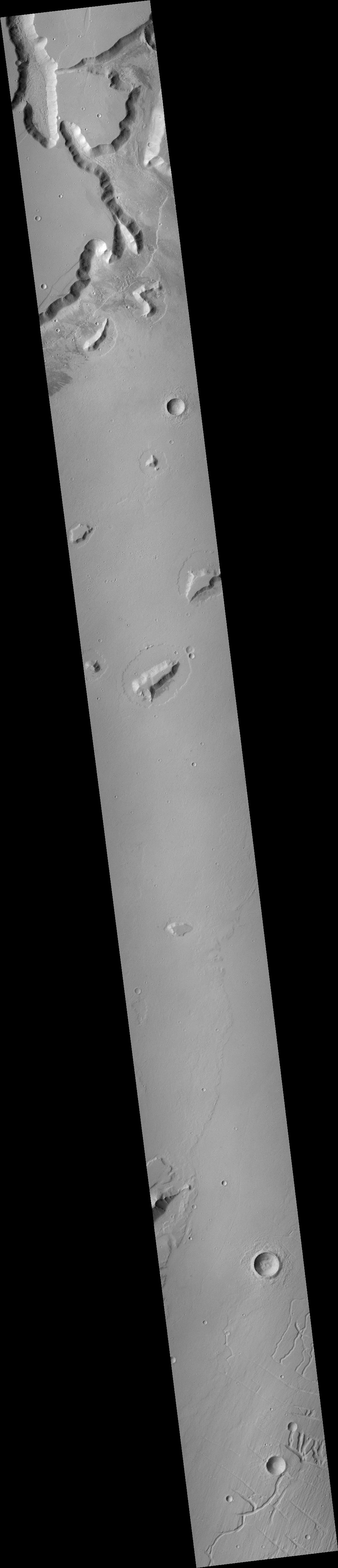
The photo to the right, rotated, cropped, and reduced to post here, was taken by the context camera on Mars Reconnaissance orbiter (MRO), designed to map the entire planet at wide-angle at lower resolution. The data is similar to the cameras on the Viking orbiters from 1976-1980, and Mars Global Surveyor from 1997 to 2006, though the coverage is far more complete. While Viking did image this location, it did so at a lower resolution, with incomplete coverage.
The context camera tells scientists where they might find interesting things to look at in greater detail. This context image of the area of the white rectangle above certainly does that, as all the mesas visible apparently are surrounded by a strange moat. Moreover, the mesas sit in what looks like a relatively young, flat, and featureless plain, as indicated by its lack of craters.
The implication of the mesas are that they are an older feature that was resistant to erosion. The overview map above suggests the first major cause of that erosion, the catastrophic flood that some scientists believe poured through Kasai Valles when a giant ice dam broke farther upstream and released a large lake in a sudden flood.
But why the moats? I can guess, but I have zero confidence on any theory. Maybe the flat plain is covered with the mud washed downstream by the flood that has now dried and can be lifted up by wind. As the wind blows it flows around the mesas, getting concentrated near the mesa and picking up speed so that it has the ability to pick up more sand and create these moats. You see something similar on beaches with rocks sitting on the sand. The waves are more efficient at pulling sand from the margins around the rocks, so they have moats.
That the moats are generally the same size on all sides suggests that the winds in this wide part of Kasai Valles have no prevailing direction. Depending on weather and season, they can blow in any direction.
To prove or disprove these theories, however, requires even closer photos.
Click for full image.
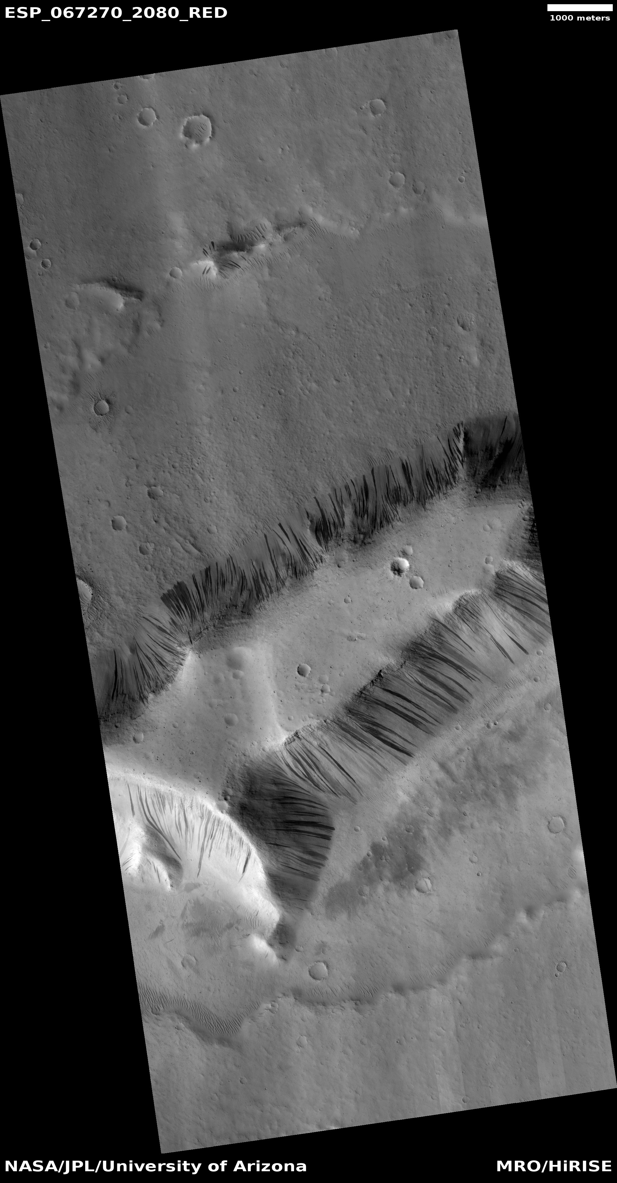
The image to the right, rotated, cropped, and reduced to post here, is today’s cool image. It zooms in on the southernmost and largest mesa, and was taken on December 2, 2020 by the high resolution camera on MRO.
This photograph raises more questions than it answers. The mesa top appears as young and featureless as the surrounding plain, with what appear to be about the same number of craters. Similarly, the moat on the mesa’s south side also appears to have a similar crater count. This suggests that the mesa, the plains, and even the moats are of approximately the same age, something that seems unlikely and if true makes all my suppositions above invalid.
Covering all the mesa’s slopes are slope streaks, a feature that even today remains unexplained and unique to Mars. At first glance you think they are avalanches, but a close look shows that they do not change the topography of the surface and leave no boulder piles at their base. Instead, they appear at high resolution to merely be a discoloration of the surface.
However, monitoring at high resolution of these slopes shows that the streaks are caused suddenly, like avalanches. Something triggers a flow of some kind down hill, that discolors the surface and over time fades.
If you look at the full image from the context camera, you can see that all the mesas in this area appear to have slope streaks. Why? What makes this location so favorable for these strange features?
At this moment no one knows. The data is too incomplete. We will have to get much closer, to the point of actually touching these features, to really find out.

On Christmas Eve 1968 three Americans became the first humans to visit another world. What they did to celebrate was unexpected and profound, and will be remembered throughout all human history. Genesis: the Story of Apollo 8, Robert Zimmerman's classic history of humanity's first journey to another world, tells that story, and it is now available as both an ebook and an audiobook, both with a foreword by Valerie Anders and a new introduction by Robert Zimmerman.
The print edition can be purchased at Amazon or from any other book seller. If you want an autographed copy the price is $60 for the hardback and $45 for the paperback, plus $8 shipping for each. Go here for purchasing details. The ebook is available everywhere for $5.99 (before discount) at amazon, or direct from my ebook publisher, ebookit. If you buy it from ebookit you don't support the big tech companies and the author gets a bigger cut much sooner.
The audiobook is also available at all these vendors, and is also free with a 30-day trial membership to Audible.
"Not simply about one mission, [Genesis] is also the history of America's quest for the moon... Zimmerman has done a masterful job of tying disparate events together into a solid account of one of America's greatest human triumphs."--San Antonio Express-News
These slope streak images you have highlighted in the past are some of my favorite “cool images”. Today’s was exceptional. The small mound to the north of your main mesa with few streaks was very cool. Seems like a few streaks there were captured in mid-slide, or the slope was gentle enough to keep the streaks short. Thanks.
What a unique mystery.
I disagree that this is caused by wind affect because the lack of smooth edges around the moat. As you noted, wind usually is not omnidirectional. Prevailing winds normally have a leading edge and a trailing edge with obvious characteristics. Very common on Mars but lacking here. Having said that, I have no answers either.
My best guess, which fits the circumstances, is the “great flood” hypothesis.
The mud plane you described would flow around these mesas, saturated with water which when frozen, “hundreds of feet down”, would expand and rise against the bed rock. A moat is formed where the bed rock rises above the ice into the Mesa formations. This would explain the ruff uneven and yet uniform edges around the mesas.
If core drilling verifies this, it means Mars has a lot of water.
One can only imagine what would happen on earth if the ocean temperature rise by just 1°. (71% of the world is covered in water not including Antarctica)
The expansion would cause The sea level to rise by nearly 200 feet flooding low lying areas and causing Florida to disappear.
The same would be true if the oceans temperature dropped by few degrees (if it wasn’t for the salt, it’s already below freezing under 2000 feet)
The ice sheets would expand, thrusting upward and outward across land.
I can imagine continental drift running into resistance which will cause mountain formation / heat and pressure with an excess volcanoes popping up which would deliver mountains of ash on top of this ice looking similar to this picture.
Amazing. Note the exceptionally “bent” streak that follows a contour from a protruding ridge below the strak on the extreame right side of the photograph, sunward face.
Mentally, looking at these steaks, my mind “sees” these streaks as flowing or propogating “downward” but I cannot understand why this particular streak , if it were “propagating down” would vear away before encountering a change in the slope.
Maybe these things form and grow “up” the slope. Like something growing.
Man, I didn’t say that did I?