Update on Curiosity’s journey in Mount Sharp, including its future route

Curiosity's future planned route
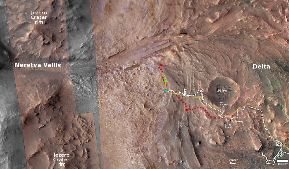
Click for original image.

The Curiosity science team yesterday released a new 360 panorama taken on August 19, 2023 by the rover’s high resolution camera, as part of an effort to document an important geological location finally reached after two previous attempts failed.

Three billion years ago, amid one of the last wet periods on Mars, powerful debris flows carried mud and boulders down the side of a hulking mountain. The debris spread into a fan that was later eroded by wind into a towering ridge [dubbed Gediz Vallis Ridge], preserving an intriguing record of the Red Planet’s watery past.

Now, after three attempts, NASA’s Curiosity Mars rover has reached the ridge, capturing the formation in a 360-degree panoramic mosaic. Previous forays were stymied by knife-edged “gator-back” rocks and too-steep slopes. Following one of the most difficult climbs the mission has ever faced, Curiosity arrived Aug. 14 at an area where it could study the long-sought ridge with its 7-foot (2-meter) robotic arm.

That panorama can be viewed here. The rover spent eleven days at this geological location, and has since moved on.

Because that panorama covers some of the same ground I have previously posted from the rover’s navigation cameras, I have instead posted above the graphic from the press release, with additional annotations, because that graphic provides new information about Curiosity’s future travels.

The white line marks Curiosity’s past travels as well as the planned route as previously released by the science team. The red line marks the additional route that the rover will follow beyond, weaving its way up Mount Sharp.

0 comments

OSIRIS-REx makes last course correction before releasing asteroid sample return capsule

OSIRIS-REx’s engineers on September 17, 2023 successfully completed the last course correction necessary before releasing the sample return capsule carrying about nine ounces of material from the asteroid Bennu, set to land in Utah on September 24th.

The spacecraft briefly fired its thrusters Sunday to change its velocity by 7 inches per minute (3 millimeters per second) relative to Earth. This final correction maneuver moved the sample capsule’s predicted landing location east by nearly 8 miles, or 12.5 kilometers, to the center of its predetermined landing zone inside a 36-mile by 8.5-mile (58-kilometer by 14-kilometer) area on the Defense Department’s Utah Test and Training Range.

Details on that landing can be found here. The capsule will be coming in at speeds comparable to that of an Apollo capsule, returning from the Moon, and will use the same maneuvers and parachutes to slow its speed to only eleven miles per hour at landing. Four helicopters will than rush to recover the capsule as quickly as possible to reduce the chance the sample will be contaminated by the Earth’s environment.

OSIRIS-Rex (renamed OSIRIS-Apophis Explorer or OSIRIS-APEX) will meanwhile fire its engines and head towards the potentially dangerous asteroid Apophis, with a rendezvous scheduled in 2029.

2 comments

Two galaxies merging

Merging galaxies
Click for original image.

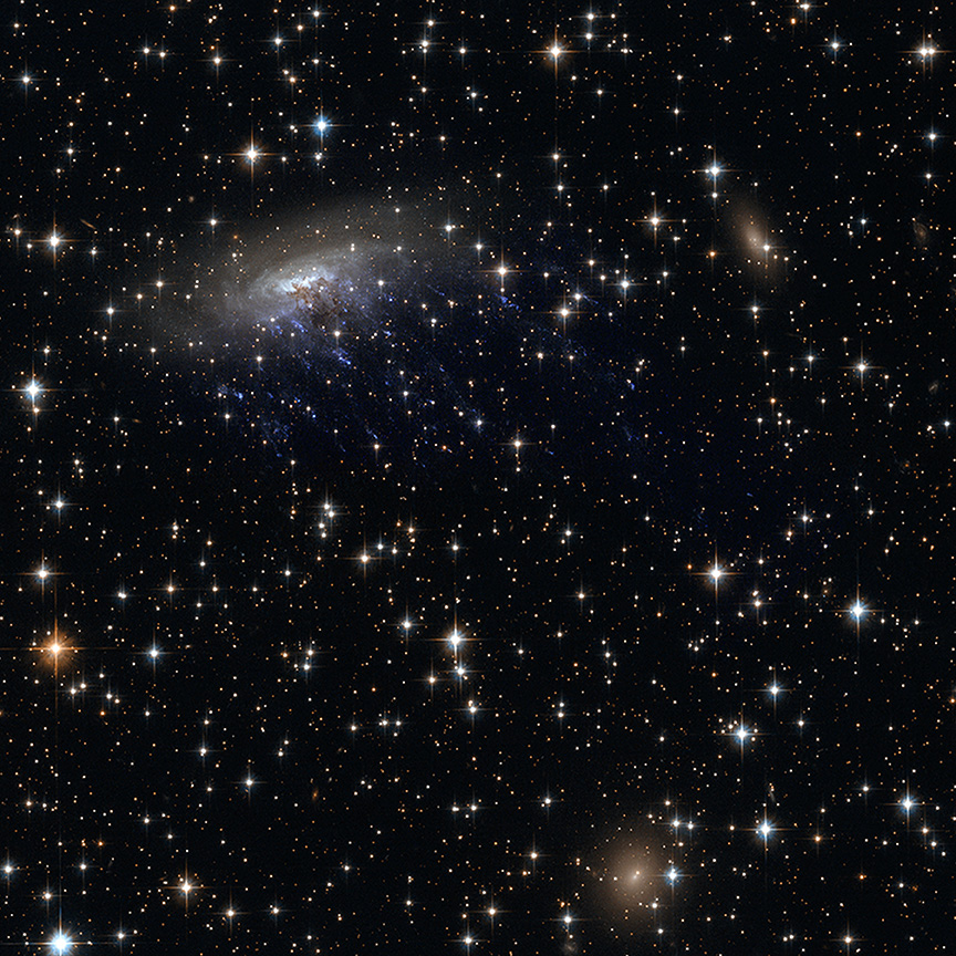
Cool image time! The picture to the right, cropped, reduced, and sharpened to post here, was taken by the Hubble Space Telescope as part of a survey project to photograph the entire Arp catalog of 338 “peculiar galaxies,” put together by astronomer Halton Arp in 1966. From the caption:

The larger galaxy (in the left of this image) is an extremely energetic galaxy type known as a Seyfert galaxy, which house active galactic nuclei at their cores. Seyfert galaxies are notable because despite the immense brightness of the active core, radiation from the entire galaxy can be observed. This is evident in this image, where the spiraling whorls of the whole galaxy are readily visible. The smaller companion is connected to the larger by a tenuous-seeming ‘bridge’, composed of dust and gas. The colliding galactic duo lie about 465 million light-years from Earth.

Note that if you ignore the blue whorls of the left galaxy, the two bright cores of these merging galaxies are about the same size. As it is unclear how long this merger has been on-going, it is possible that the galaxy on the right, in circling the left galaxy, drew out those whorls and that tenuous bridge. Other scenarios are also possible, however, such as the galaxy on the left stripping and scattering the arms of the galaxy on the right.

1 comment

A triangular Martian hill

A triangular Martian hill
Click for full image.

Cool image time! The picture to the right, cropped, reduced, and sharpened to post here, was taken on May 29, 2023 by the high resolution camera on Mars Reconnaissance Orbiter (MRO). It shows what the science team labels an “unusual shaped hill” that is estimated to be about 20 to 40 feet high.

What makes it unusual? First, it sticks up out of the endless northern lowland plains for no obvious reason, though its shape suggests the existence of bedrock topography that is now buried by the dust and debris that coats the surface of those plains.

Second, the hill itself suggests that it formed after it was covered with debris. Note the crater near its northeast cliff. It appears that the cliff chopped off part of the crater, suggesting that the hill was once level with the surrounding terrain. Some later underground pressure pushed it upward, with its angled sides determined by existing faults.

Why those forces tilted the hill upward as it did, with only its eastern fringes raised, is a question a wide view might answer.
» Read more

0 comments

New analysis of Chandrayaan-1’s lunar orbital data might explain its detection of widespread surface hydrogen on the Moon

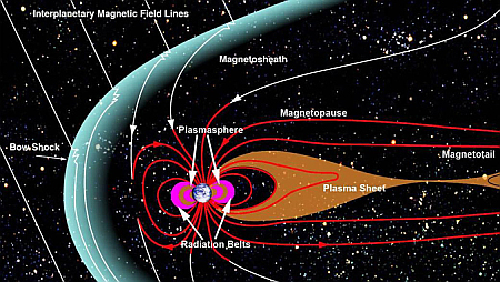
The Earth's magnetic field, shaped by the solar wind
The Earth’s magnetic field, shaped by the solar wind

One of the significant finds coming from India’s first lunar orbiter, Chandrayaan-1, was the detection of hydrogen in many places across the entire lunar surface, in places where it seemed impossible for hydrogen to be there, even if it was locked in a molecule like water.

Researchers in Hawaii now think they have found an explanation by linking that data to the Earth’s long magnetotail, formed by the solar wind pushing against the Earth’s magnetic field. The graphic to the right illustrates that process. The scientists focused on the kind of weathering processes that occurred both when the Moon was inside that tail, and when it was not.

Li and co-authors analyzed the remote sensing data that were collected by the Moon Mineralogy Mapper instrument onboard India’s Chandrayaan 1 mission between 2008 and 2009. Specifically, they assessed the changes in water formation as the Moon traversed through Earth’s magnetotail, which includes the plasma sheet.

“To my surprise, the remote sensing observations showed that the water formation in Earth’s magnetotail is almost identical to the time when the Moon was outside of the Earth’s magnetotail,” said Li. “This indicates that, in the magnetotail, there may be additional formation processes or new sources of water not directly associated with the implantation of solar wind protons. In particular, radiation by high energy electrons exhibits similar effects as the solar wind protons.”

In other words, the evidence suggests that the hydrogen signal seen by Chandrayaan-1 might have been a very temporary implacement of that hydrogen by the solar wind, which ceases during the Moon’s periodic passages through the magnetotail. The Moon’s harsh environment then causes that hydrogen to vanish, only to reappear when it is once again exposed to the solar wind.

None of this is confirmed, so some skepticism is required. If true, however, it would provide further evidence that the hydrogen signal seen at the lunar poles that scientists hope is evidence of ice in the permanently shadowed craters might be nothing of the sort, and we shall find little ice there.

7 comments

Polygons and scallops in the high mid-latitudes of the Martian lowland plains

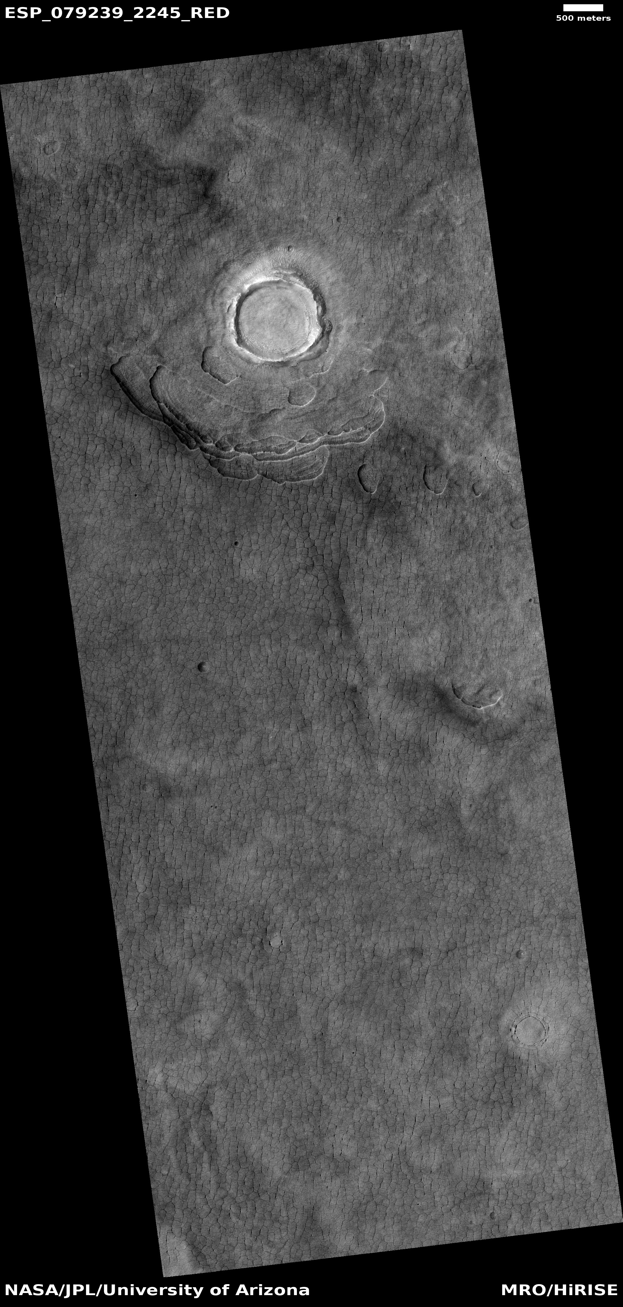
Polygons and scallops in the high mid-latitudes of Mars
Click for original image.

Cool image time! Only yesterday I posted an image of polygons in the dry equatorial regions of Mars, where little evidence of near-surface ice is found and are thought to be the remnants from a long-dried lakebed.

Today we take a look at some polygons in the mid-latitudes of the icy northern lowland plains, where near-surface ice appears ubiquitous and as it sublimates away with the changing seasons causes all kinds of strange formations, including polygons.

The picture to the right, cropped, reduced, and sharpened to post here, is a good example, centered on a 0.6-mile-wide bright crater that appears to be filled with glacial ice. The image was taken on June 22, 2023 by the high resolution camera on Mars Reconnaissance Orbiter (MRO), and is located at 44 degrees north latitude on the western edge of Utopia Basin. As noted by the MRO science team in 2006 for a different MRO picture with similar features:
» Read more

0 comments

The drying out of Mars’ tropics

The drying out of Mars
Click for original image.

Cool image time! The picture to the right, cropped, reduced, and sharpened to post here, was taken on June 26, 2023 by the high resolution camera on Mars Reconnaissance Orbiter (MRO). The science team calls the features surrounding these small 20 to 60 foot high hills “polygon features,” an apt description and a geological feature that is seen in many places on Mars.

When these features are found in the icy higher latitudes, it is believed they are formed in connection to the freeze-thaw cycle that causes cracks in the near surface ice. When found in the dry equatorial regions, where these polygons are located, they are usually thought to be ancient evidence of past standing water that left behind these cracks, much like the cracks seen in mud after the water has evaporated away on Earth.

The formation of these tiny hills is a bit more complex.
» Read more

0 comments

Chandra: New X-ray composite images of galaxies and supernovae remnants

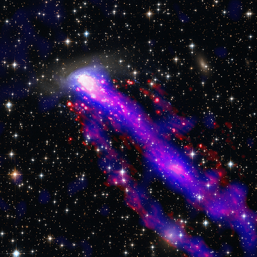
Chandra image
Click for original image.

The science team for the Chandra X-Ray observatory today released five new composite images of two galaxies, two supernovae remnants, and the center of the Milky Way, combining data from multiple telescopes looking in radio, infrared, optical, and X-ray wavelengths.

The image to the right, reduced and sharpened to post here, is one of those pictures. From the press release:

As the galaxy moves through space at 1.5 million miles per hour, it leaves not one — but two — tails behind it. These tails trailing after ESO 137-001 are made of superheated gas that Chandra detects in X-rays (blue). ESO’s Very Large Telescope shows light from hydrogen atoms (red), which have been added to the image along with optical and infrared data from Hubble (orange and cyan).

The inset shows just the Hubble optical image, reduced by about 50%, to get a clearer sense of the galaxy itself. It appears to be a jelly-fish galaxy, flying through space at right angles to its plane and with tendrils of stars trailing off below.

The other four images are as interesting. The full set, including separate images in the individual wavelengths prior to combination, can be found here.

0 comments

Weird rocks on Mars

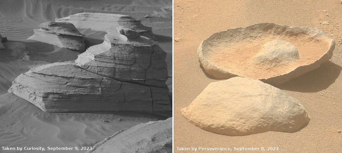
Weird rocks seen by Curiosity and Perseverance
For original images, go here and here.

Time for two cool images, this time from both of the American rovers on Mars.

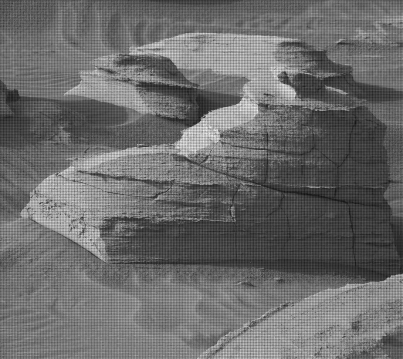
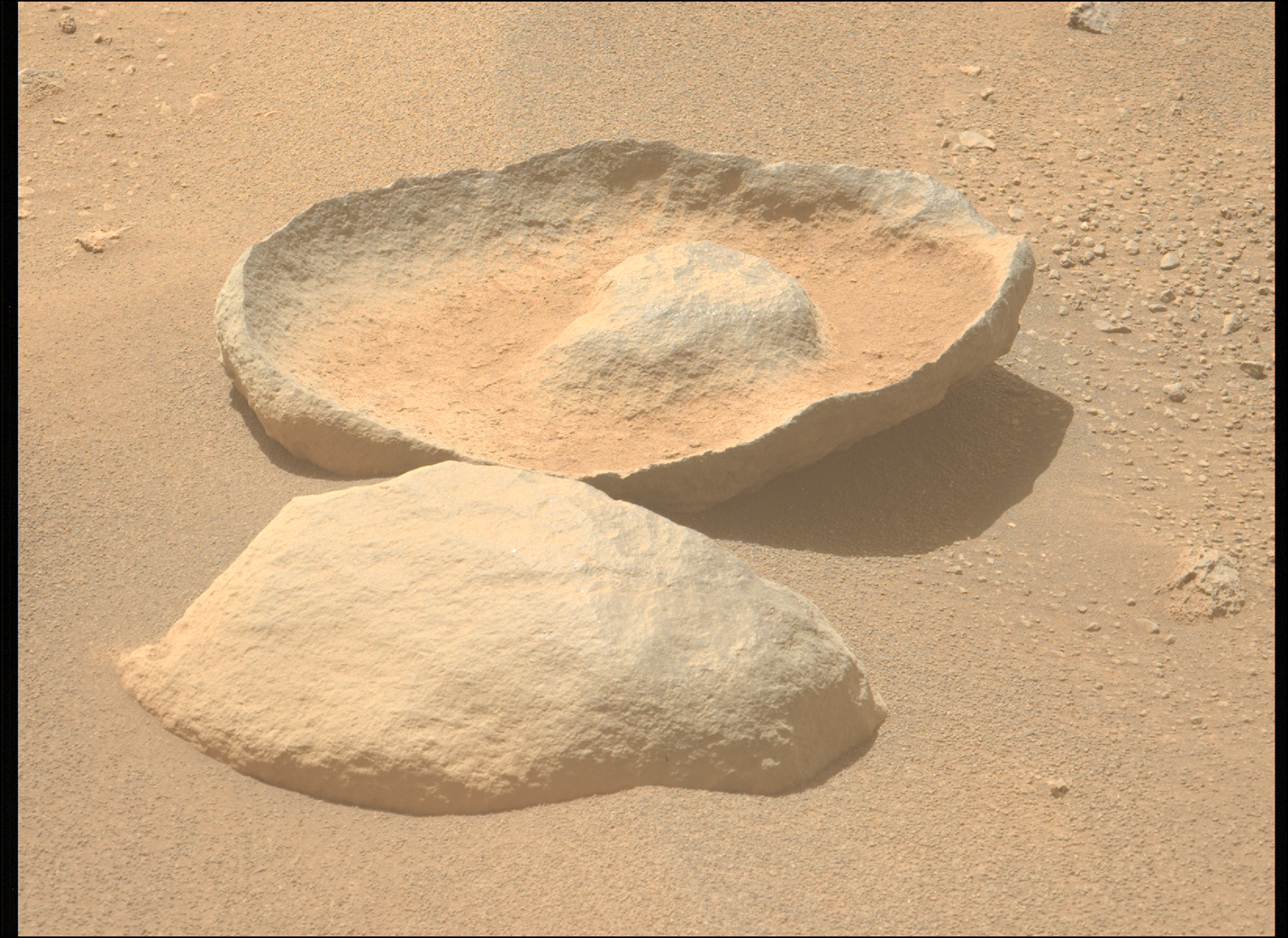
The left picture above was taken on September 9, 2023 by the high resolution mast camera on Curiosity. It shows what appears to be a many-layered but rounded rock which appears typical of the many boulders that cover the terrain through which Curiosity is presently traveling. In the past the layered rocks that Curiosity has observed lower on the flanks of Mount Sharp have not been rounded. Instead, the delicate layers have often extended outward at the rock’s edges, almost like paper or threads. For some reason, the layers in the rocks here have been eroded smooth, suggesting they were once covered by flowing water or ice, able to round the rough edges in a way that Mars’ thin atmosphere can’t.

What is puzzling is the location, higher on Mount Sharp. One would expect the reverse, with such erosion more typical lower on the mountain and uneroded delicate layers more common higher on the mountain.

The right picture above was taken on September 8, 2023 by one of the high resolution mast cameras on the rover Perseverance in Jezero Crater, about 5,000 miles to west of Curiosity. It shows a rock whose shape is so strange it is hard to fathom a geological process that would result in this form. Possibly the rock was a surface layer on a larger round boulder, and the normal freeze-thaw cycle of Mars caused it crack off as one piece. The lump in the middle however makes this explanation questionable.

Also puzzling is the curved shape. On Mars almost no geological layers have been found that are curved. They are generally flat and horizontal, reflecting the lack of tectonic processes that on Earth often twist and squash layers.

2 comments

Ingenuity completes 58th flight on Mars

Overview map
Click for interactive map.

Ingenuity yesterday successfully completed its 58th flight on Mars, flying 571 feet to the northwest for 107 seconds at a height of 33 feet.

The overview map above shows with the green line the approximate route of the helicopter. Though the Ingenuity engineering team has updated the flight log (at the link above), the route has not yet been added to the Perseverance interactive map. I am guessing at that route based upon the flight plan posted on September 7, 2023, which stated the rover would head northwest as well as image science targets. That suggests it was flown above Perseverance’s planned route, as indicated by the red dotted line.

This particular flight was different than recent flights, which have generally lasted slightly longer and covered a slightly longer distance, probably so the helicopter could find a safe landing spot. This time Ingenuity landed about 23 seconds early, though the distance traveled was still slightly longer. The difference once again was almost certainly caused by the helicopter’s software picking a good landing spot. It just got above its planned landing spot sooner than expected, found a good pad, and then landed.

The blue dot marks Perseverance’s present location. It is presently moving west to reach what the scientists consider an important geological contact between two layers.

0 comments

Repeating moonquakes on Moon found to be caused by remaining sections of Apollo 17’s LM

Scientists reviewing the archive seismic data produced by the seismometers placed on the Moon by the Apollo missions have discovered that repeating small moonquakes in that data were actually caused by base of Apollo 17’s Lunar Module (LM) that provided a launchpad for the part of the LM that lifted the astronauts off the Moon.

Triangulating the origin of the mystery quakes, researchers surprisingly realized they came from the Apollo 17 lunar lander base, which expands and vibrates each morning as it becomes heated by the sun.

“Every lunar morning when the sun hits the lander, it starts popping off,” Allen Husker, a Caltech research professor of geophysics who worked on the project, said in a statement. “Every five to six minutes another one, over a period of five to seven Earth hours. They were incredibly regular and repeating.”

That the extreme range of temperatures experienced by the LM could cause detectable quakes as the LM base expanded suggests strongly how difficult it is for a spacecraft to survive the lunar night lasting 14 Earth days. For all we know, that base has now literally fallen apart due to these stresses. This in turn suggests it is highly unlikely that India’s Pragyan rover will come back to life when the sun rises on September 22, 2023.

3 comments

Lucy gets first images of its first target asteroid, Dinkinesh

The asteroid Dinkinesh as seen by Lucy

The asteroid probe Lucy has obtained its first images of Dinkinesh, the first of the ten asteroids the spacecraft is hoping to visit during its twelve year voyage to the Trojan asteroids.

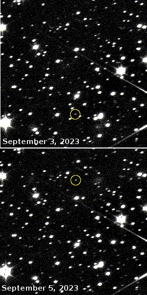
The image to the left shows the motion of that asteroid over a two day period when Lucy was getting the pictures.

Lucy took these images while it was 14 million miles (23 million km) away from the asteroid, which is only about a half-mile wide (1 km). Over the next two months, Lucy will continue toward Dinkinesh until its closest approach of 265 miles (425 km) on Nov. 1, 2023. The Lucy team will use this encounter as an opportunity to test out spacecraft systems and procedures, focusing on the spacecraft’s terminal tracking system, designed to keep the asteroid within the instruments’ fields of view as the spacecraft flies by at 10,000 mph (4.5 km/s). Lucy will continue to image the asteroid over the next months as part of its optical navigation program, which uses the asteroid’s apparent position against the star background to determine the relative position of Lucy and Dinkinesh to ensure an accurate flyby. Dinkinesh will remain an unresolved point of light during the long approach and won’t start to show surface detail until the day of the encounter.

Lucy’s primary targets are asteroids in the two Trojan groups that orbit the Sun in the two Lagrange points in same orbit as Jupiter, fore and aft of the gas giant by 60 degrees. For a map of Lucy’s full mission profile, go here.

4 comments
1 56 57 58 59 60 89