Engineers place Pragyan into sleep mode

With lunar sunset looming, engineers have completed all work on both the lander Vikram and the rover Pragyan and have prepared Pragyan as best as possible to survive the long 14-Earth-day long lunar night.

Currently, the battery is fully charged. The solar panel is oriented to receive the light at the next sunrise expected on September 22, 2023. The receiver is kept on.

All data from Vikram’s instruments has been transmitted back to Earth, through the rover. It appears that the mission has been using the rover has the main communications relay, not the lander. It also appears there is no expectation of the lander surviving the lunar night.

4 comments

Petrified dunes on Mars?

Petrified dunes on Mars?
Click for original image.

Cool image time! The picture to the right, cropped, reduced, and sharpened to post here, was taken on May 31, 2023 by the high resolution camera on Mars Reconnaissance Orbiter (MRO).

I think the many parallel ridges are likely hardened and petrified dunes of sand because of their craggy nature. Dunes of sand would have a smoother, softer look, and in fact, if you look at some of the dunes inside the depression at the bottom-right of the picture you will see ridges with exactly that look, smooth and curved.

Nor is it unreasonable to believe these ridges are petrified dunes, as orbital data over time has found that many of the dunes on Mars, even those that look active, are not and have likely been hardened for centuries.

As for the ridges running at right angles to each other in the picture’s middle left, I have no idea. Possible we are looking at ancient dykes of lava that pushed up through cracks and faults, but this is pure guess.
» Read more

0 comments

The splatter surrounding a mid-latitude Martian crater

A channel in the splatter of a Martian crater
Click for original image.

Cool image time! The picture to the right, cropped, reduced, and sharpened to post here, was taken on April 12, 2023 by the high resolution camera on Mars Reconnaissance Orbiter (MRO). It shows what the scientists simply label as “Northern Mid-latitude Terrain”.

I have focused in on that meandering channel and the landscape around it. On Earth we would assume that channel marks the drainage of a river or stream, possibly also shaped by a glacier at some point because of its U-shaped profile. This guess is strengthened by the elevation data from MRO, which shows the channel descending to the southwest about 440 feet along its 2.2 mile length.

The channel and the eroded look of the surrounding terrain suggests strongly the presence of near-surface ice at this location, which is not unreasonable based on its 32 degree north latitude. The wider look below only adds further strength to this hypothesis, but also adds a lot more details explaining the genesis of this strange landscape.
» Read more

0 comments

Vikram takes movie of Pragyan rover as it roves

Pragyan as seen by Vikram
Click for movie.

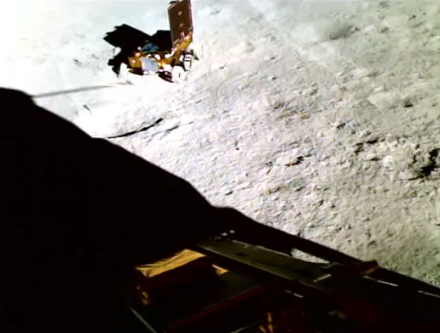
Using one of Vikram’s lander cameras, engineers have produced a short movie of India’s Pragyan rover as it rotated to avoid a small crater about ten feet ahead.

The picture to the right is from that 16-second movie, near its end. It appears that the engineers operating Pragyan were unhappy with almost any route ahead from its present position, as they rotated Pragyan almost 360 degrees, and even attempted forward motion at one point and then resumed rotation.

It is not clear if any of the craters visible in this picture are the crater that caused the detour. The movie however does provide a sense of scale. Pragyan is small, but it is able to maneuver easily using its six wheels.

5 comments

Buried ridges at the bottom of a Martian abyss

Buried ridges in a Martian abyss
Click for full image.

Today’s cool image could be labeled a “What the heck?!” photo, as the origin of its most distinct feature is utterly baffling. The picture to the right, cropped, reduced, and sharpened to post here, was taken on June 18, 2023 by the high resolution camera on Mars Reconnaissance Orbiter (MRO), and shows what look like a collection of meandering ridges peeking out from a terrain covered by thick dust.

The scientists label this dust-covered ground, as well as the ripple dunes to the south in the full image, “sand sheets.” Without question, the ground here seems to resemble a Sahara-like terrain. It is utterly featureless, other than the few bedrock features that poke up out of that sand. In the full image some peaks stick out, but it the meandering ridges in this section that are most intriguing. They are reminiscent of rimstone dams in caves, but what formed them remains baffling, since cave rimstone dams are formed by the interaction of limestone and water, and there is absolutely no evidence of any near surface ice at this location in the dry equatorial regions of Mars.

All the ridges signify is a buried terrain formed in some inexplicable way.
» Read more

4 comments

Scientists believe they have recovered the first known interstellar meteorite

A scientific expedition in the Pacific off the coast of Papua New Guinea has found what it thinks are spherules from the first known interstellar meteorite that hit the Earth on January 8, 2014 and dubbed IM1. From their preprint paper [pdf]:

On 8 January 2014 US government satellite sensors detected three atmospheric detonations in rapid succession about 84 km north of Manus Island, outside the territorial waters of Papua New Guinea (20 km). Analysis of the trajectory suggested an interstellar origin of the causative object CNEOS 2014-01-08: an arrival velocity relative to Earth in excess of ∼ 45 km s−1, and a vector tracked back to outside the plane of the ecliptic. The object’s speed relative to the Local Standard of Rest of the Milky-Way galaxy, ∼ 60 km s−1, was higher than 95% of the stars in the Sun’s vicinity.

In 2022 the US Space Command issued a formal letter to NASA certifying a 99.999% likelihood that the object was interstellar in origin.

Using a “magnetic sled” that they dragged across the seafloor, the scientists collected about 700 spherules thought to come from the meteorite, of which 57 have been analyzed and found to have properties that confirm their interstellar origin. As they note in their paper, “The spherules with enrichment of beryllium (Be), lanthanum (La) and uranium (U), labeled “BeLaU”, appear to have an exotic composition different from other solar system materials.”

The “BeLaU” elemental abundance pattern does not match terrestrial alloys, fallout from nuclear explosions, magma ocean abundances of Earth, its Moon or Mars or other natural meteorites in the solar system. This supports the interstellar origin of IM1 independently of the measurement of its high speed, as reported in the CNEOS catalog and confirmed by the US Space Command.

Based on the sparse data, the scientists speculate that these spherules could have come from the crust of an exoplanet, the core collapse of a supernova, the merger of two neutron stars, and even possibly “an extraterrestrial technological origin.” They have no idea, but all these are among the possibilities.

8 comments

Pragyan snaps first pictures of Vikram sitting on the Moon

Vikram as seen by Pragyan
Click for original image.

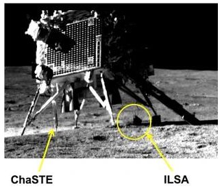
India’s space agency ISRO has released the first two pictures from the Pragyan rover showing the Vikram lander that bought both to the Moon safely.

The picture to the right is the close-up image, which shows two of Vikram’s science instruments. CHASTE is a probe that has been measuring the temperature of the Moon’s regolith at this spot, while ILSA is a seismometer for measuring the seismicity around the landing site.

Both spacecraft have been on the lunar surface now for one week, which means they are both halfway through their nominal two-week mission that lasts until lunar sunset, occurring on September 4th. Neither were designed to survive the 14-day-long lunar night, though engineers will attempt to kept both alive.

4 comments

The prevailing winds in Mars’ volcano country

The prevailing winds in Mars' volcano country
Click for original image.

Today’s cool image is actual one new picture and four past images, which taken together reveal something about the larger wind patterns on Mars. The picture to the right, cropped, reduced, and sharpened to post here, was taken on June 27, 2023 by the high resolution camera on Mars Reconnaissance Orbiter (MRO) and shows a tiny wind-swept section of the giant volcanic ash field dubbed the Medusae Fossae Formation, about the size of the subcontinent of India and thought to be source of most of the dust on Mars.

The innumerable parallel thin ridges here all suggest that the prevailing winds blow from the southeast to the northwest. As they blow, the scour the surface ash out, and sometimes reveal the underlying bedrock, which here shows up as those small peaks and a handful of northeast-to-southwest trending larger ridges. Note too that the picture shown is only a small section of the full image, which shows that this landscape continues for a considerable distance in all directions.
» Read more

0 comments

Residue ice in southern mid-latitude Martian crater?

Residue ice in the southern mid-latitudes of Mars?
Click for original image.

Cool image time! The picture to the right, rotated, cropped, reduced, and sharpened to post here, was taken on April 10, 2023 by the high resolution camera on Mars Reconnaissance Orbiter (MRO). It shows an unnamed 1.2-mile-wide crater at about 35 degrees south latitude with what appears to be residual glacial ice hugging its north interior wall.

As this is in the southern hemisphere, the ground immediately below the south-facing interior wall of the crater is going to be in shadow the most, and thus it will also be the place where any surface or near-surface ice will survive the longest. In this case it appears that from the bumpy nature of that residual ice it has also been sublimating away. Within it however remains the faint hint of multiple layers, suggesting about a dozen past climate cycles with each new cycle producing a new but smaller layer with less ice.

The material in the southern half of the crater floor appears to be dust formed into ripple dunes.
» Read more

0 comments

JAXA scrubs launch of X-Ray telescope & SLIM lunar lander due to high winds

SLIM's landing zone
Click for interactive map.

Because of high winds, Japan’s space agency JAXA yesterday scrubbed the last launch of its H2A rocket, carrying the XRISM X-Ray telescope and the SLIM lunar lander.

A nice description of both payloads can be found here. XRISM is a simplified reflight of the Hitomi X-Ray telescope that failed immediately after launch in 2016.

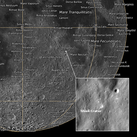
Though SLIM carries a camera and two secondary payloads, both designed to hop along on the surface and obtain some data, its main mission is engineering, testing whether a robotic spacecraft can achieve a precision landing with a target zone of 100 meters, or 310 feet. The map to the right shows SLIM’s landing site, with the white dot in the close-up inset a rough approximation of that entire target zone. If successful this technology will make it possible to put unmanned planetary probes in places previously thought too dangerous or rough.

All three craft are designed to operate for only about fourteen days, during the daylight hours of the 28-Earth-day-long lunar day.

2 comments

Flow channels on Mars

Flow channels on Mars
Click for original image.

Cool image time! The picture to the right, rotated, cropped, reduced, and sharpened to post here, was taken on May 13, 2023 by the high resolution camera on Mars Reconnaissance Orbiter (MRO). It shows what the scientists call a “channel and depression”, though to my eye everything looks like flow channels, descending to the east.

The drop from the narrow northern channel to wider southern channel is about 200 feet, with the small crater on the left sitting about halfway between. To our Earthbound eyes, something clearly flowed downhill from that northern channel into the wider channel. What we don’t know now is what the material was that did the flowing?

Was it liquid water? Glaciers? The overview map below provides some context, though it doesn’t actually provide an answer.
» Read more

0 comments

Both Vikram and Pragyan functioning as planned on the Moon

Pragyan on the Moon
Click to see full movie.

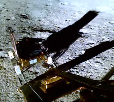
According to tweets from India’s space agency ISRO, both the Vikram lander and the Pragyan rover are functioning as planned on the lunar surface, with the rover successfully activating its two science instruments.

The image to the right, taken by Vikram, shows the rover as it completed its roll down the ramp onto the lunar surface. This is a screen capture from a movie showing that roll down, which you can see by clicking on the picture. Since then it has moved another 26 feet from the lander.

I must add once again that Vikram did not land “on the south pole”, as too many so-called news organizations have been falsely claiming. It landed at about 69 degrees south latitude, quite a distance from that pole, in a flat region with no permanently shadowed craters. It is not specifically looking for water, though its instruments might help explain the orbital data that suggests there are areas on the surface of the Moon where hydrogen is somehow present.

If so many news outlets can’t seem to get these very basic facts about this mission correct, one must ask what else do they get wrong routinely? I don’t ask, because I always assume their information is wrong, check it constantly, and find repeatedly that they get numerous basic facts incorrect, especially when it comes to reporting on politics.

6 comments
1 58 59 60 61 62 89