Frank Rubio on ISS sets new record for an American in space

Though Frank Rubio was only supposed to do a six month mission, a leak on the Soyuz capsule that brought him and his two crewmates into space has resulted in all three doing a mission exceeding one year, and setting a new record for an American in space.

Today Rubio broke the old American record of 355 days, set by Mark Vande Hei in 2022. When they return on September 27, 2023, all three will have spent 371 days in space, the third longest manned mission in history, exceeded only by Sergei Avdeyev’s 381 in 1999 and Valeri Polyakov’s 437 in 1994-1995, both on Russia’s Mir space station.

Based on my interviews with Polyakov and Musa Manarov (who was on the first mission with Vladimir Titov to spend one year in space — 366 days total — in 1988) for my book Leaving Earth, it will take Rubio about one year to fully recover from this mission, though he will likely be able to function almost normally within a month or so.

It remains interesting that these American records set by Rubio and Vande Hei occurred because of decisions by the Russians, not the American space agency NASA. NASA has consistently resisted doing long missions on ISS, even though this is exactly the kind of medical research required if we are to send humans on multi-year missions to Mars and beyond. Even more embarrassing, the longest NASA planned mission, flying Scott Kelly for 340 days, was touted by NASA as a year-long mission, even though it was never going to and did not achieve that distinction.

In doing this research the Russians have always led, and appear to continue to do so on ISS.

0 comments

Ridge in Martian lowland plains

Tiny ridge in Martian lowlands
Click for original image.

Today’s cool image is interesting not because it shows us some spectacular Martian terrain, but because the most distinct feature is a thin ridge only a few feet high that pokes up out of the northern lowland plains for apparently no reason.

The picture to the right, cropped, reduced, and sharpened to post here, was taken on July 1, 2023 by the high resolution camera on Mars Reconnaissance Orbiter (MRO). The ridge is about 1.8 miles long, and is only about five feet high on its western end, rising to about 25 feet on its eastern end.

The colors differences indicate that the ridge’s peak is likely bedrock, and the surrounding greenish/blue hue suggesting sand and rocks covered with dust. The ridge might be the top of a deeper buried topological feature but that is only a guess.
» Read more

2 comments

Layered glaciers in two small Martian craters

Layered glaciers in two small Martian craters
Click for original image.

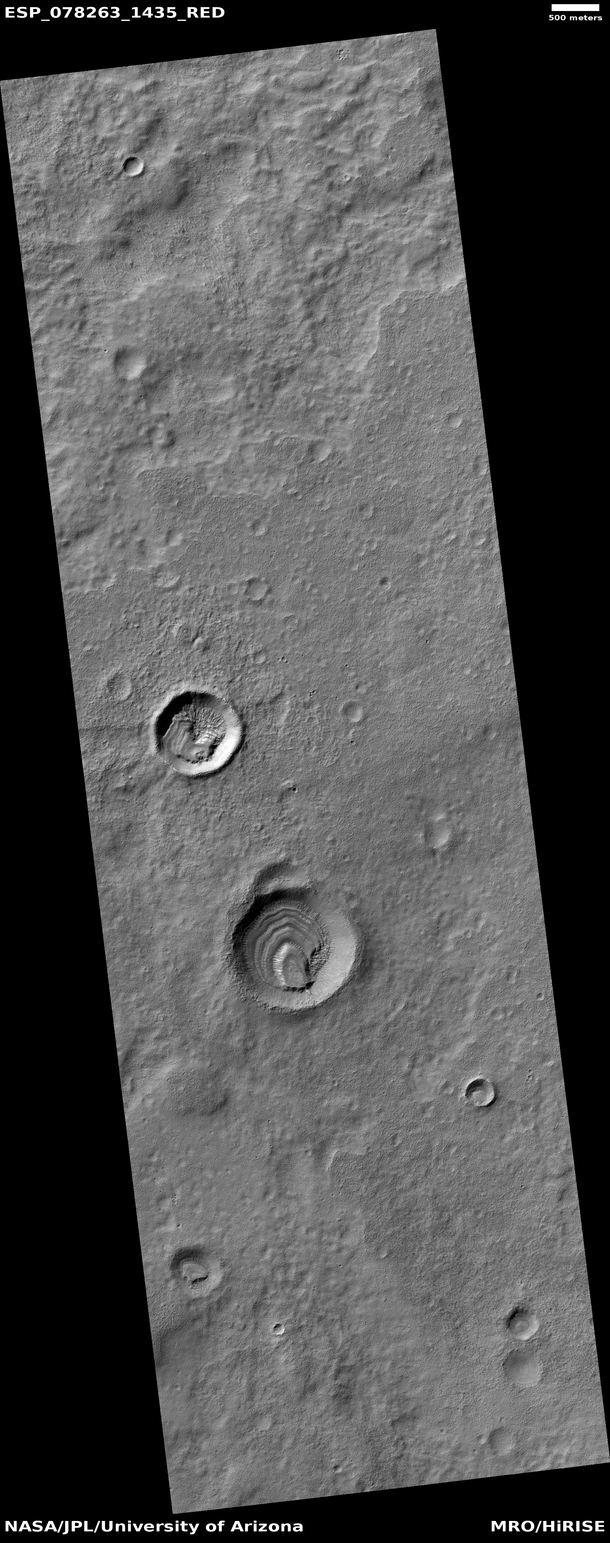
Cool image time! The picture to the right, cropped, reduced, and sharpened to post here, was taken on April 7, 2023 by the high resolution camera on Mars Reconnaissance Orbiter (MRO). It shows what planetary scientists label somewhat vaguely as “layered deposits,” because though the features inside both of these craters strongly resemble glacial ice features, until this is confirmed a good scientist remains skeptical.

I can be more bold, and call the layers glacial in both of these small and very shallow craters (less than a 100 feet deep). To explain this it is important to understand that the lighting and shadows make it hard to distinguish the high points of these layers. Based on the elevation data from MRO, the ground descends to the south, and the mesa in the southern half of each crater’s floor is actually far below the layers and material to the north.

This elevation data suggests that the layered material is surviving best against the crater’s northern interior wall, which at this latitude, about 36 degrees south, will be in shadow the most.
» Read more

0 comments

Ingenuity flies on, completing its 57th flight

Overview map
Click for interactive map

On September 3, 2023 Ingenuity successfully completed its 57th flight on Mars, traveling 713 feet for two minutes and nine seconds. As noted at the tweet at the link, the helicopter has now accumulated more than 100 minutes of flight time.

As it has on almost all its recent flights, the helicopter flew a slightly longer distance for slightly longer that its flight plan, probably because it was taking time to find a safe landing spot.

The green dot on the overview map above shows Ingenuity’s new location. It has moved west and north of Perseverance, following the rover’s planned route as indicated by the red dotted line. The blue dot marks Perseverance’s present location. The yellow lines indicate the approximate area of the mosaic below, just released by the Perseverance science team, taken on July 8, 2023 by the rover’s high resolution camera and cropped and reduced to post here. It shows us the rover’s eventual path forward, into that mountain gap.

Mosaic looking west at the rim of Jezero Crater
Click for original, full resolution image (a large file).

2 comments

Japan successfully launches XRISM X-ray space telescope and SLIM lunar lander

SLIM's landing zone
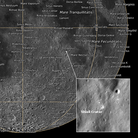
Map showing SLIM landing zone on the Moon.
Click for interactive map.

Japan today (September 7th in Japan) successfully used its H-2A rocket to place both the XRISM X-ray space telescope and SLIM lunar lander into orbit.

As of posting XRISM has been successfully deployed. SLIM has not, as it needs to wait until after a second burn of the rocket’s upper stage about 40 minutes later. The map to the right shows SLIM’s landing target on the Moon, where it will attempt a precision landing within a zone about 300 feet across.

This was Japan’s second launch this year, so it does not get included in the leader board for the 2023 launch race:

62 SpaceX
39 China
12 Russia
7 Rocket Lab
7 India

In the national rankings, American private enterprise still leads China in successful launches 71 to 39. It also still leads the entire world combined, 71 to 64, while SpaceX by itself now trails the rest of the world (excluding American companies) only 62 to 64.

0 comments

Martian ice islands amidst a Martian ice ocean

Glacier country on Mars

Martian ice islands in a Martian sea of ice
Click for original image.

Cool image time! The picture to the right, cropped, reduced, and sharpened to post here, was taken on June 19, 2023 by the high resolution camera on Mars Reconnaissance Orbiter (MRO).

The scientists simply labeled this “Deposit Layers,” but that description hardly covers the incredibly diverse and puzzling features within the picture. We see layers, swirls, and radiating groves, all suggesting glacial features. We see mesas apparently covered with ice, and a flat surrounding lower plain that appears to be also ice but acting more like an ocean or sea. If there is any visible bedrock at this location it is difficult to determine.

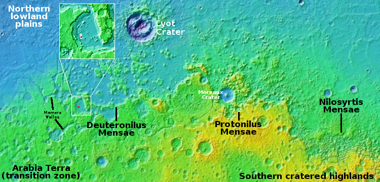
The dominance of ice features is not surprising however, considering the location. The red dot on the overview map above marks this location, in a large 80-by-56-mile-wide basin inside the 2,000-mile-long northern mid-latitude strip I dub glacier country, because almost every image from MRO shows distinct glacial features. This particular basin is considered part of the segmented and indistinct canyon dubbed Mamers Valles, that winds its way through this glacier country of chaos terrain to eventually drain into the northern lowland plains.

From a geologist’s perspective, however, the layers are the most significant feature in the picture, as those layers mark the innumerable climate cycles that have apparently shaped the Martian surface. Mapping those layers will likely involve decades of work, but when largely completed we shall have a very precise history of the red planet’s geological history, going back several billion years.

1 comment

LRO takes image of Vikram on Moon


Click for interactive map. To see the original
image, go here.

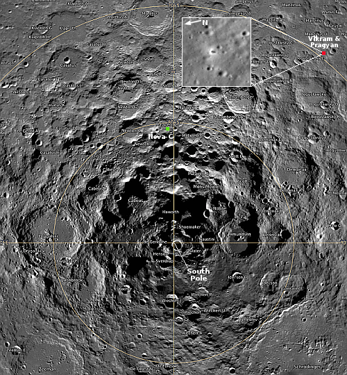
The science team for Lunar Reconnaissance Orbiter (LRO) yesterday released an oblique image taken of India’s Vikram lander, on August 27, 2023, four days after the lander touched down about 370 miles from the south pole.

The LROC (short for LRO Camera) acquired an oblique view (42-degree slew angle) of the lander. … The bright halo around the vehicle resulted from the rocket plume interacting with the fine-grained regolith (soil).

That image is shown in the inset to the right. I have cropped it to focus on Vikram itself, which is in the center of the inset, with its shadow to its right, the opposite of all the surrounding craters. Pragyan is in this image, but neither it nor its tracks appear visible. The rover had moved west from the lander, which would be downward to the line of three craters near the bottom of the inset. To get a better sense of Pragyan route, compare this image with the map India’s space agency ISRO released on September 2nd.

0 comments

Martian mounds surrounded by moats

Martian mounds with moats
Click for original image.

Cool image time! The picture to the right, cropped, reduced, and sharpened to post here, was taken on February 1, 2023 by the high resolution camera on Mars Reconnaissance Orbiter (MRO). It shows what the camera team labels “Circular Mounds Surrounded by Moats,” which when all the known data is considered are probably caused by a spray of small meteorites landing on a field of ice.

Why ice? The location is at 37 degrees south latitude, in the cratered southern highlands of Mars, where many images show glacial-type features inside many craters. In fact, all the nearby craters at this location appear to have such features, suggesting the presence of near-surface ice trapped in these craters.

The picture actually looks at the floor of another such crater, with the mounds in the image’s upper left the crater’s indistinct central peaks. Though only 8.5 miles wide, the crater is deep, with interior walls that quickly rise 2,800 feet to the rim. That depth further suggests ice, as any snow that fell here in the far past could easily become trapped, inside what could be thought of a cold trap.
» Read more

1 comment

Bubbling but frozen terrain on Mars

Bubbling but frozen terrain on Mars
Click for original image.

Cool image time! The picture to the right, cropped, reduced, and sharpened to post here, was taken on June 8, 2023 by the high resolution camera on Mars Reconnaissance Orbiter (MRO). It shows some of the more unusual terrain found at the higher latitudes in the Martian northern lowland plains.

How do we explain this strange landscape? Based on what little we presently know about Mars, at 40 degrees north latitude this bubbly-looking surface probably indicates the presence of a lot of near-surface ice that at some time in the past was heated for some reason and thus bubbled upward to form these mounds. Think of tomato soup simmering.

Unlike simmering tomato soup, this terrain is solid and no longer bubbling. We are looking at a soup that has frozen even as it bubbled. The process could have been like an ice volcano, the ice turning to thick slurry that froze quickly, like lava. Or it could have happened fast, and then froze to remain unchanging in the eons since.
» Read more

0 comments

JAXA schedules last H-2A rocket launch, carrying X-Ray telescope and lunar lander

SLIM's landing zone
Map showing SLIM landing zone on the Moon.
Click for interactive map.

Japan’s space agency JAXA today announced that it has finally rescheduled the launch of its XRISM X-Ray telescope and its SLIM lunar lander launch for September 7, 2023, lifting off using the last flight of its H-2A rocket.

The previous launch attempt several weeks ago was scrubbed due to high winds. This new launch date has a window of seven days, which means if weather scrubs the September 7th launch they will be able to try again immediately within that window.

The white dot on the map to the right shows the targeted landing site of SLIM, which is testing the ability of an unmanned probe to land precisely within a tiny zone of less than 300 feet across.

Meanwhile, with the retirement of the H-2A rocket and its replacement having not yet flown successfully (its first launch failed in March), Japan after this launch will be in the same boat as Europe, without a large rocket and lacking the ability to put large payloads into orbit.

1 comment

Endeavour Dragon capsule carrying four astronauts safely splashes down

SpaceX’s Endeavour Dragon capsule safely splashed down shorty after midnight last night in the Atlantic off the coast of Florida, completing a six month mission for two Americans, one Russian, and one astronaut from the United Arab Emirates (UAE).

The UAE astronaut, Sultan Al Neyadi, flew as a paying passenger, obtaining his flight through the private space station company Axiom, which in turn purchased the ferrying services to and from ISS from SpaceX. The Russian flew as part of the barter deal that NASA presently has with Russia, with each flying astronauts on the other nation’s capsules at no cost in order to make sure everyone knows how to use them in case of emergency.

Several additional details: First, in the post-splashdown press conference SpaceX officials revealed they are presently building a fifth manned Dragon capsule to add to its fleet, and are also aiming to fly each as much as fifteen times. This suggests they are anticipating a lot of business hauling both NASA and commercial passengers into space.

Meanwhile, the Russian-launched crew on ISS that launched last September and includes American Frank Rubio is targeting a return-to-Earth on September 27, 2023. If so, they will have completed a 371 day flight, or almost thirteen months. This I think is the second longest human flight so far in space, exceeded only by Valeri Polykov’s fourteen-and-half month mission in the 1990s.

3 comments

Engineers had Vikram do short flight hop prior to shutting down

Indian engineers revealed today that prior to putting the Vikram lander to sleep for the long lunar night, they had the lander use its rocket engines to do a short up and down flight. From the first link:

β€œOn command it (Vikram lander) fired the engines, elevated itself by about 40 cm as expected and landed safely at a distance of 30 to 40 cm away,” ISRO said in an update on β€˜X’.

Before doing the hop engineers stored Vikram’s instruments and rover ramp, then redeployed them afterward to gather a tiny bit of new data before putting everything into hibernation.

The hop test proved that Vikram’s engines could be restarted even after being on the Moon for almost two weeks, and thus could potentially be used on a future sample return mission. It also suggested a future mission could choose to change its landing site periodically by use of its landing engines.

1 comment
1 57 58 59 60 61 89