July 20, 1969: “We came in peace for all mankind.”

An evening pause: In honor of the fiftieth anniversary.

The astronauts plant the American flag, after they had unveiled a plaque on the lunar module with the words, “We came in peace for all mankind.”

This was an American achievement, accomplished because our free and competitive society gave us the resources and trained talent to make it happen. We did it for all mankind, in good will, but we did it, no one else.

It is time that we as well as everyone else do it again.

The Untouched Moon

Montes Carpatus
Click for full image.

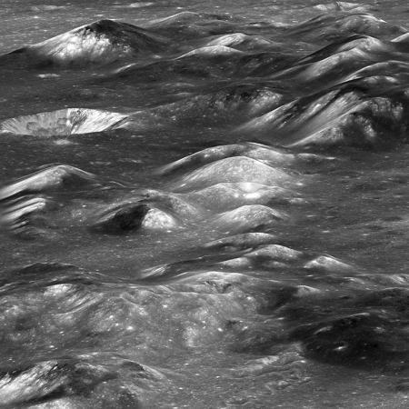
In celebration of Apollo 11: Continuing the theme of yesterday’s cool image, where I noted how little of the Moon we have really seen, today’s cool image gives us a breath-taking glimpse of one such untouched region, the Montes Carpatus region.

The photograph to the right, reduced to post here, was released by the Lunar Reconnaissance Orbiter (LRO) science team in March 2018. From the release:

Volcanic rocks are our best window to the deep interior of the Moon, and the Montes Carpatus has no shortage of volcanic landforms: lava flows, pyroclatic deposits, rilles, and more! Lavas are formed as the mantle begins to melt, so by sampling volcanic rocks of various ages from regions across the Moon scientists can reconstruct the range of compositions and processes over time. The Montes Carpatus formed as a result of the giant impact that formed the mighty Imbrium basin, the mountains are actually the raised rim of the basin.

Today is the 50th anniversary of the Apollo 11 landing. If you had told anyone involved in that mission that fifty years later no significant further manned exploration of the Moon had yet occurred, they would have scoffed.

It is a terrible condemnation of my generation, the generation that followed Apollo 11, that we did nothing grand like this. I challenge the generations today to reach higher, and do better.

July 20, 1969: “One small step…”

An evening pause: In honor of the fiftieth anniversary.

Neil Armstrong takes the first steps on the Moon. Note his focus is almost entirely on describing what he sees and experiences. He is doing this for two reasons, first to provide knowledge of the Moon to the world, and second to provide engineers as much information as possible for future missions.

This focus explains why the first thing he does is to get a contingency rock sample, just in case they need to leave the Moon quickly.

Note also that when Buzz Aldrin joins Armstrong on the surface, he is as professional and calm, proving that the way he has been portrayed by some recent movies as as undisciplined jerk is simply a slander. He would not have been picked for this mission if he really behaved that way.

He wanted to be the first, and lobbied to get that chance. After the decision was made he got down to work to make the mission a success.

For a different view of these same events, watch this video.

July 20, 1969: “The Eagle has landed”

An evening pause: In honor of the fiftieth anniversary.

Note the calm tone in all the voices, even when something is not quite right. To do really great things, one must not let one’s emotions run the show. You need to be cool-headed and focused on the task at at hand. If only today’s adult generation, especially in the world of politics, would do the same.

Just before Armstrong brings Eagle down, you will hear a voice say “60 seconds,” then “30 seconds.” That is mission control telling him how much time they estimate he has before he runs out of fuel.

Below the fold is the same last few minutes of the landing, produced by the Lunar Reconnaissance Orbiter (LRO) science team using its high resolution images to recreate a simulation of what Armstrong saw in his window. Remember, the view in the original 16mm film was out Aldrin’s window.

» Read more

Eagle undocks, Apollo 11, July 20, 1969

An evening pause: In honor of the fiftieth anniversary of Apollo 11, today’s evening pause shows the moment when the lunar module Eagle undocked from the command module Columbia. Though this video includes communications with mission control at the start, the actual undocking occurred on the back side of the moon, when the astronauts were out of touch with the Earth.

Near the end of the video, after they have reacquired communications with the ground, you can hear a recitation of a long string of numbers. This is mission control providing the astronauts the numbers that had to be uploaded into their onboard computer so that it could correctly fire the spacecraft engines at the right time and for the right duration.

A wave on the Moon

A lunar ejector blanket

Continuing this week’s celebration of the 50th anniversary of the Apollo 11 mission means we get to look at another cool image from the Moon. The photograph on the right, reduced to post here, was released by the Lunar Reconnaissance Orbiter (LRO) science team in 2016.

What are we looking at? At first glance it looks like a black & white photograph of The Wave in northern Arizona. What it is instead is the pattern of ejecta laid down across the surrounding terrain immediately after the impact that created relatively fresh Chaplygin Crater. From the website:

The delicate patterns of flow across, over, and down local topography clearly show that ejecta traveled as a ground hugging flow for great distances, rather than simply being tossed out on a ballistic trajectory. Very near the rim lies a dark, lacy, discontinuous crust of now frozen impact melt. Clearly this dark material is on top of the bright material so it was the very last material ejected from the crater.

Below the fold is a wider shot of the entire crater and its surrounding terrain, with the rectangle indicating the region covered by the close-up above The dark crust near the rim mentioned in the quote can clearly be seen.
» Read more

Weird lunar crater

Concentric crater in Apollo Basin on the Moon

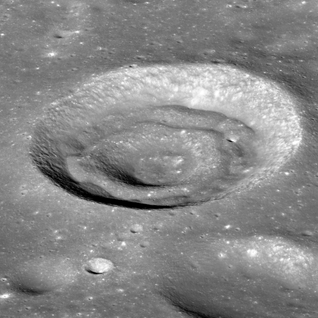
In celebration of the 50th anniversary of the Apollo 11 mission, it is time for another cool image from the Moon. The photograph on the right, reduced to post here, was taken by Lunar Reconnaissance Orbiter (LRO) in 2013. It shows a weird crater with concentric features that is found within Apollo Basin, a large 334-mile-wide double-ringed impact feature in the southern hemisphere of the Moon’s far side.

Concentric craters have an inner rim whose formation mechanism is not yet entirely understood, but the concentric mounds may indicate that there is a discontinuity, such as layers with different strengths, in the subsurface excavated by the impact.

Or to put it more bluntly, they really have no idea why this crater ended up looking as it does.

Apollo 11 First Stage liftoff

An evening pause: This was originally posted as an evening pause in 2016. I think that today, the fiftieth anniversary of the launch of Apollo 11, it is appropriate to repost it. As I wrote then,

Though the video is more than 8 minutes long, the actual events recorded lasted only about 30 seconds, beginning 5 seconds before T minus 0.

What struck me most as I watched this was the incredible amount of complex engineering that went into every single small detail of the rocket and the launch tower and launchpad. We tend to take for granted the difficulty of rocket engineering. This video will make you appreciate it again.

It is also mesmerizing. A lot happens in a very short period of time.

Tonight’s evening pause begins eight days of pauses dedicated to celebrating, and reliving, the Apollo 11 mission. To the Moon!

Apollo 11 in real time

Link here. I should have posted this link earlier. As I post this the Saturn 5 has just launched.

Pick your moment. They will be showing the mission in real time over the next week.

Hat tip Steve Golson for prompting me.

Correction: If you go to the link you can either choose to watch from one minute before launch, or click on the “Now” button to see the status at this moment fifty years ago.

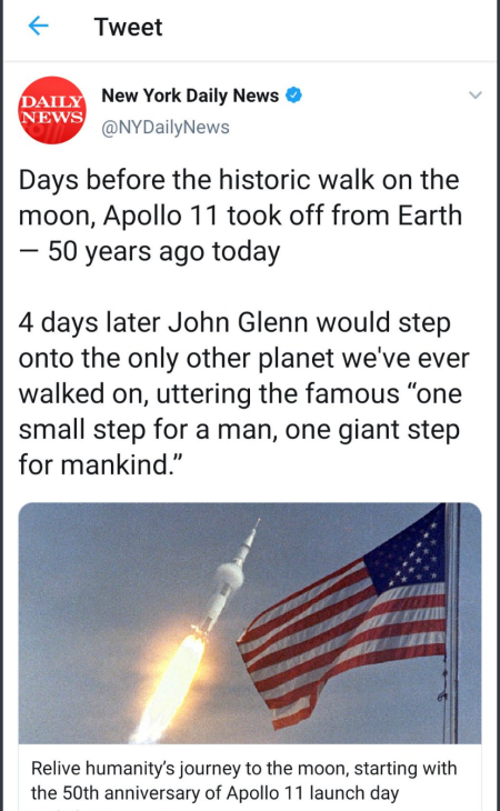
Modern journalism celebrates Apollo 11, badly

Daily News gets Apollo 11 very wrong

The image on the right came from the twitter feed of the Daily News in New York. It has since been removed, and it is also possible that it was a prank. Nonetheless, in less than fifty words this modern epitome of today’s journalism gets practically everything wrong about Neil Armstrong’s first step on the Moon and the first words he spoke.

John Glenn?

“One giant step for mankind”?

The tweet also calls the moon a “planet”, which I can live with since eventually the definition of a planet will include the Moon. Still, an educated person in this context would have used “world” instead.

I can’t imagine the level of incompetent education someone would have to go through to write this and not realize how much of it is embarrassingly wrong. Nor can I imagine how it is possible for everyone at the Daily News to not realize it as well, unless they are equally uneducated.

Tonight I begin an eight day series of evening pauses dedicated to the Apollo 11 mission, showing the key moments, as they happened. Rather than read some bad and often incorrect interpretation of this singular moment in human history, I am going to give you a chance to live it, as I did, fifty years ago.

Hat tip Jeff Bliss for the Daily News tweet. My readers know that I will not have anything to do with Twitter (which likely reduces my webpage traffic and likely my income as well), but I think it is designed to force people to act like a hateful and childish mob. Or exhibit their ignorance, which this tweet does so well.

My ethics will not allow me there. My observations repeatedly confirm for me the wisdom of this decision.

Frank Sinatra – The House I Live In

An evening pause: Since it is July 4th, and the news is filled with depressing outrages from ignorant social justice warriors who have no knowledge at all about the just and noble roots that founded the United States, I think it necessary to post this magnificent song performed by Frank Sinatra.

Written and produced in 1945, as World War II was ending, the short film tried to encapsulate in one short song the true meaning of the American experiment. This version below includes the lead-in scene to show the context for the song, as sung in the film. Some might find that opening overly preachy, but in the context of World War II and the recent discovery then of the Nazi death camps, it is heartfelt, real, and quite accurate. Please watch it all, and recognize this is what the United States — now being condemned routinely by leftist hate-mongers — is really about.

The song begins by asking, “What is America to me?” It answers it clearly in the final verse:

The town I live in
The street, the house, the room
The pavement of the city
Or a garden all in bloom
The church, the school, the clubhouse
The million lights I see
But especially the people
that’s American to me. [emphasis mine]

And that means all the people, not just those who agree with you.

1776 – Hatching an Egg

A mid-day pause: Posted by me on almost every Fourth of July since this site was founded, it is time to do it again. From the 1976 movie version of the 1972 musical, 1776. As I said in those earlier posts, “not only did the musical capture the essence of the men who made independency happen, it is also a rollicking and entertaining work of art.”

And as John Kennedy said of himself, ourselves, and these founding fathers. “We stand for freedom.”

Far right radicals make declaration

A group of far right radicals, some of which had been accused of many crimes against the legal government, today made a declaration that clearly required their arrest for daring to defy the powers-that-be.

From the first two paragraphs:

When in the Course of human events it becomes necessary for one people to dissolve the political bands which have connected them with another and to assume among the powers of the earth, the separate and equal station to which the Laws of Nature and of Nature’s God entitle them, a decent respect to the opinions of mankind requires that they should declare the causes which impel them to the separation.

We hold these truths to be self-evident, that all men are created equal, that they are endowed by their Creator with certain unalienable Rights, that among these are Life, Liberty and the pursuit of Happiness. — That to secure these rights, Governments are instituted among Men, deriving their just powers from the consent of the governed, — That whenever any Form of Government becomes destructive of these ends, it is the Right of the People to alter or to abolish it, and to institute new Government, laying its foundation on such principles and organizing its powers in such form, as to them shall seem most likely to effect their Safety and Happiness. Prudence, indeed, will dictate that Governments long established should not be changed for light and transient causes; and accordingly all experience hath shewn that mankind are more disposed to suffer, while evils are sufferable than to right themselves by abolishing the forms to which they are accustomed. But when a long train of abuses and usurpations, pursuing invariably the same Object evinces a design to reduce them under absolute Despotism, it is their right, it is their duty, to throw off such Government, and to provide new Guards for their future security.

Without a doubt our country’s corrupt ruling class in Washington finds these words appalling and unacceptable. Some, mostly leftists and Democrats, consider the man who wrote these words evil, and the men who signed it worse.

But then, these fools have never read these words or anything thing else Thomas Jefferson and the other Founding Fathers wrote. Or if they have, they weren’t smart enough to understand them.

Happy Fourth of July! And as it says on the Liberty Bell, “Proclaim liberty throughout all the land unto all the inhabitants thereof.”

Apollo landing tapes for sale

An intern who in 1976 purchased more than a thousand surplus 2-inch videotapes from NASA for $218 is now going to auction off three of those reels that show the Apollo 11 moon walk.

Back in 1976, NASA gave 1,150 reels of 2-inch Quadruplex videotape to a government surplus auction. Gary George, a former intern at NASA’s Johnson Space Center, snapped up the lot of them for $218, in the hopes of selling them to news stations to record over for $50 a pop. He never watched them, but because his dad was a space buff, kept three of the tapes marked as “Apollo 11 EVA” (aka Extravehicular Activity, better known as a spacewalk). When he eventually watched the tapes, he realized that he had one of three surviving copies of one of the greatest feats of human ingenuity, the July 20, 1969 Moon landing. Now, those videotapes will be auctioned off to the highest bidder when Sotheby’s will mark the 50th anniversary of the moon landing by putting the tapes up for sale on July 20th, at a starting bid of $700,000.

“I had no idea there was anything of value on them,” George said in an interview with Reuters. He started to get suspicious in 2006, after NASA admitted they had lost the tapes, and believed they could have been in the 2,614 boxes of Apollo mission tapes that were sent to a storage facility in late 1969. George got in touch with video archivist David Crosthwait in California, who had the necessary equipment to view the vintage tapes. In December 2008, George played the reels and quickly realized what he had been storing over the last few decades. He contacted NASA about the reels but “an agreement could not be reached,” according to the auction listing, and off to the auction block they go as part of an auction dedicated to Space Exploration.

The saddest part of this story are the tapes George sold to television stations to use to back-up their daily broadcasts. Some of those tapes probably contained historical recordings of the Apollo missions. While I suspect these tapes were not NASA’s only copies, I cannot be sure, which means some of the source material for the Apollo missions was likely lost.

First movie of solar eclipse rediscovered

The first movie ever made of a solar eclipse, taken in 1900, has been rediscovered and restored.

The film was taken by British magician turned pioneering filmmaker Nevil Maskelyne on an expedition by the British Astronomical Association to North Carolina on 28 May, 1900. This was Maskelyne’s second attempt to capture a solar eclipse. In 1898 he travelled to India to photograph an eclipse where succeeded but the film can was stolen on his return journey home. It was not an easy feat to film. Maskelyne had to make a special telescopic adapter for his camera to capture the event. This is the only film by Maskelyne that we know to have survived.

I have embedded the movie below the fold.
» Read more

Signals detected from experimental satellite that failed in 1967

NASA has confirmed that the signals detected in 2016 do come from an experimental satellite, LES-1, that failed in 1967.

LES stands for Lincoln Experimental Satellite, and was the first in a series of test satellites built by MIT’s Lincoln Laboratory for the Air Force. It was launched on February 11, 1965. Though it was reported to be operating properly, it was placed in an incorrect orbit that made its experiments useless. It ceased transmissions in 1967 and was thought lost, until amateur astronomer Phil Williams picked up a signal in 2016.

Williams told Southgate Amateur Radio News that the signal he detected from his base in Cornwall seemed to cycle every four seconds, diminishing and returning to create an eerie repetitive sound.

It would later be determined that the fluctuation was the result of the long-lost satellite barreling end over end through the void of space, causing variations in the light reaching the solar panels that Gunter’s Space Page says likely now power the depleted batteries of this 65 lb (30 kg) relic of the space age.

Scientists are unclear as to how the satellite continues to operate — Williams himself expressed some uncertainty as to how the craft might continue to function given the particularly harsh environment of space and its tendency to destroy electronic equipment.

This story is nothing more than a curiosity, but a fine one nonetheless.

London and art

Trafalgar Square

Yesterday we took the train to London and settled into a really super modern hi-tech hotel dubbed “The Hub by Premier Inns.” It is also the crummiest hotel I have ever stayed at. I picked it because it was well recommended and was located less than a block from Trafalgar Square, shown on the right. And yes, it is new and fancy, with motion-controlled LED lights and fancy touch buttons and aps to control everything. It is also tiny, cramped, the controls are too limited and too difficult to decipher, even for a science journalist like myself. I suppose I shouldn’t complain, as it was reasonable in price considering the location. I still dislike the hi-tech nature of the room that only ended up limiting our convenience and comfort.

And the hotel didn’t even have an ice machine!

National Gallery in London

Today we wandered about the square, watching the street performers (buskers in British lingo) and admiring the statues and sights. Then we went into the National Gallery to enjoy some of humanity’s greatest art, as were a class of elementary school children as shown in the picture on the right.

The museum was packed with people from everywhere. I saw Japanese, Chinese, and Israeli tour groups. I saw people of all types clearly from London, including several school groups like the one to the right.

Interestingly, these crowds were all found in the permanent exhibits. One temporary exhibit we wandered through, art by an modern abstract artist by the name of Sean Scully, was practically empty.
» Read more

Wales Day 7

Cregennan

The home of 18th century composer John Williams

The tree

In our final day of our Wales journey, we spent the day strolling across the beautiful countryside of Cregennan, one of several parks along the flanks of the Cadair Idris range, which runs north-south to the coast. This park is closest to the ocean, so at our highest point we were overlooking the Irish Sea and the town of Barmouth.

The three pictures on the right are only a small selection of the beauty of this region. There were several magnificent lakes nestled amid the mountains and fields. There were pastures with numerous sheep, some eating, some resting like white blobs on the green grass, and some “baa’ing” at each other. It was especially entertaining when a lamb started calling out for its mother, the mother responding, and then the two searching and finding each other.

And of course there were the standing stones and ancient ruins scattered about on several hilltops.

The abandoned house in the second picture is of special interest because it had been the home of an obscure 18th century Welsh composer by the name of John Williams. Williams was actually quite successful in his time, but only recently have some locals rediscovered unpublished manuscripts of his work. They plan a performance this fall.

Apparently his father was a hat-maker of some note, able to accumulate enough wealth to build this large country house in such a setting. Though I don’t know this, I suspect his success came from providing high quality hats to the upper classes, and this in turn gave his son the contacts necessary to become even more successful as a composer.

The last photo was taken as we walked downhill toward the ocean in a forested area beside a flowing stream, passing numerous waterfalls. This area is where our tour leader, Hywel “Taff” Roberts, was born and grew up, so he could give us some extra historical details about everything we saw. For example, the giant tree in that last picture was something that he remembered since childhood, home for birds and animals galore. It is old now, which is why several large branches have broken off.

Tomorrow the tour ends, and Diane and I will be taking the train to London, where we will spend two days before flying back to the states.

Wales Day 6

Sheep on the flanks of Cader Idrisc

Stone walls on the flanks of Cader Idris

Approaching the halfway point in the hike up Cader Idrisc

After yesterday’s long hike on Mount Snowdon, today was planned as an easier day. First we changed locations, driving south to the village of Dolgellau.

In the morning we heard two short presentations, first about the first discovery of Wales by tourists in the 1700s, and second a more scholarly look at the place names of Wales that appear connected to Arthur. In this case the speaker, Scott Lloyd of the Royal Commission on Ancient and Historical Monuments of Wales, was focused more on what is really known, and was thus less sure about Arthur’s links to Wales than our previous expert, Gareth Roberts. Lloyd has documented the many place names (see his book, The Arthurian Place Names of Wales), but he has also documented the important detail that most started appearing after the first writings about Arthur started to appear, with most appearing several centuries after Arthur supposedly lived. This suggests that the names were chosen because of the legend, not because the man had been there.

In the afternoon some of us did a short hike halfway up the nearby mountain Cader Idris. The first picture shows the mountain at the top right, with sheep in the center, and a hawthorn tree in bloom to the left. The second picture shows the trail going uphill parallel to one of the many typical stone walls found everywhere in Wales. The land is very rocky, and to make it better for grazing farmers would clear the stones from the fields, putting them in piles to the side. Then, when the enclosure laws were passed in the early 1800s they used those stones to build the walls to define their property lines.

The third picture shows Taff and Barbara ahead of me, with Cader Idris in the distance. Shortly thereafter we stopped to lie on the soft heather to chat and admire the countryside and the grey rocky slope going up to the peak ahead of us. We then headed back down for dinner and an evening in town.

Wales Day 4

Sygun Fawr

Today's hike

Merlin's Pool

Foundation at top of hill

Today’s adventure in Wales was a pleasant seven mile hike up onto a small hill, Dinas Emrys, nestled in the pass in Snowdonia National Park that crosses from north to south Wales past Mount Snowdon. Our hotel, Sygun Fawr, can be seen in the lower left corner in the first picture on the right, which I took from the top of this hill. If you look close, you can see the window of our second floor room, looking out at the mountains.

The hike was through some of the lushest green woods I’ve ever seen, as illustrated by the second picture on the right. The trail itself was clearly very old, with stone steps and even a simple bridge made of flat stones and laid across a stream with a single larger rock in the center for support.

The hill itself is associated with Merlin in a number of ways. For example, the pool at the base of the waterfall in the third picture has been called Merlin’s Pool for centuries. Furthermore, Merlin supposedly hid a treasure in a cave somewhere on the hill, which will only be discovered by someone with golden hair and blue eyes and who will be guided to the cave by a bell ringing.

Legend also tells this tale:

Fleeing Anglo-Saxon invaders Vortigen came to Wales and chose the hillfort as his retreat. However all efforts at building on the site failed, with workers returning daily to find collapsed masonry. Vortigern was counselled to seek the help of a young boy born of a virgin mother; a suitable boy was found named Myrddin Emrys (Merlin Ambrosius). Vortigern’s plan to kill Myrddin to appease the supernatural powers preventing him from building his fortress was scorned by Myrddin who instead explained that the fort could not stand due to a hidden pool containing two dragons. The White Dragon – he explained – of the Saxons would in time be defeated by the British Red Dragon.

The fourth pictures shows Gareth Roberts, our guide who as mentioned yesterday has been researching Welsh Arthurian place names, standing on the foundation of the ruin at Dinas Emrys’ top. To his left and slightly lower down on the hill in a gully was a second foundation and a pool from a natural spring. This spring was another reason this hilltop was a favored site for a stronghold, as it not only gave clear views both up and down the valley, was very defensible, but also had a ready supply of water. A fortress here would withstand attack for a considerable time.

Tomorrow we climb Mount Snowdon itself, The hike’s length will likely be about nine miles, and will gain 2,900 feet in elevation, somewhat comparable to many hikes in southern Arizona. The weather looks excellent, with spring temperatures at the mountain’s base.

Wales Day 3

Bryn Celli Ddu

Arthur's Table

John Jo splitting slate

Our travels today in Wales took us to three sites, all completely different.

First we visited Bryn Celli Ddu, a neolithic burial chamber, built about 5,000 years ago and shown in the top right photo. After following a well-defined path along the edge of two fields, we all entered this mound and stood in the chamber inside. The entrance shown in the image was aligned with the summer solstice so that the sun at sunrise would beam directly into the inner chamber.

Next, we drove to the northeast corner of the island of Anglesey to climb a flat-topped hill called Arthur’s Table. Our guide, Gareth Roberts, has been doing extensive research on the place names in Wales that appear to link directly to the legend of King Arthur. It is his contention (supported by those place names as well as research by others) that Arthur was actually a Welsh military leader, born of Roman parents (who had integrated into Welsh society) and who united the tribes to fight the Saxon invaders in the sixth century, after the Romans had abandoned the British Isles. He has found more than a hundred place names in this part of Wales named in honor of Arthur. He has also found in the written record much evidence linking Arthur to Wales and the war to resist the Saxons.

This particular hilltop has been identified by archeology as the location of a significant Welsh village from the time the Romans were conquering Great Britain. The middle right photo, taken from the top, looks east across the Menai Strait that separates Anglesey from the mainland, with the mountains of Snowdonia beyond. This strait is where the Romans crossed in their first attempt to conquer Anglesey and Wales.

Roberts’ thinks that the Round Table from the King Arthur legends was a misinterpretation by later French and British storytellers of this important Welsh hilltop village. Instead of being a table where Arthur ruled with his knights, the table was this hilltop, where that Roman invasion was first spotted during their initial invasion. Five hundred years later, when the Saxons invaded and Arthur led the resistance to them, Roberts’ believes the name was given because in some way Arthur was connected to it.

The third image shows slate cutter John Jo as he demonstrates how to split slate into the thin slate tiles that are used to cover rooftops. We watched this demonstration as part of a full tour of the National Slate Museum, nestled within the mountains on the way to Snowdonia, where for more than hundred years one of the world’s biggest slate mines mined, processed, and sold slate. Closed since 1969, the mine facility now serves as a museum. The most spectacular feature of this mine facility was the still functioning giant water wheel, more than fifty feet in diameter, that was turned by a stream of gravity-fed water at its base and was used to run all the belts that powered all the belt-driven machinery in the facility. The video of the wheel, embedded below the fold, shows the wheel as we saw it today. Unfortunately it does not include any people in it for scale, though one of the last shots shows a ladder for accessing the wheel’s top. Trust me, a person seems dwarfed by this wheel.

We then drove up over the mountain pass in Snowdonia National Park to our hotel, nestled at the base of Mount Snowdon. We shall be spending the rest of our trip hiking these mountains. The hike tomorrow will once again be led by Gareth Roberts and will show us further links between Arthur and Wales. On Sunday we will attempt to hike to the top of Mount Snowdon.
» Read more

Fascist scientists propose excluding 85% of solar system from human use

The tyrannical Earth moves to oppress future spacefarers: Scientists have now proposed a new fascist plan designed to exclude any human development in 85% of the entire solar system.

Great swathes of the solar system should be preserved as official “space wilderness” to protect planets, moons and other heavenly bodies from rampant mining and other forms of industrial exploitation, scientists say.

The proposal calls for more than 85% of the solar system to be placed off-limits to human development, leaving little more than an eighth for space firms to mine for precious metals, minerals and other valuable materials.

While the limit would protect pristine worlds from the worst excesses of human activity, its primary goal is to ensure that humanity avoids a catastrophic future in which all of the resources within its reach are permanently used up. [emphasis mine]

These fascists really only want power. They really have no interest in preserving anything. If their proposal was ever made law it would put control over that 85% in the hands of bureaucrats on Earth, not the people who will be living and working in space and who would also know best how to handle the situation. Also, their justification for the proposal, to prevent humans from using up all the available resources, is beyond ludicrous. We haven’t yet come close to using up Earth’s resources, even though doomsayers have been predicting that to happen repeatedly for the past century.

This story more than anything provides a window into the future political conflicts that will occur once humans finally establish space colonies. Much as the American colonies had to revolt from Great Britain’s overbearing power, colonists in space will have to do the same to get away from the same overbearing power coming from Earth.

Posted on a ferry taking us from Dublin, Ireland, to Holyhead, Wales.

Cannon Beach, Oregon

Haystack Rock, Cannon Beach, Oregon

Posting has been somewhat mixed this week because Diane and I are out in Oregon at a beach-side hotel in Cannon Beach. We and my oldest friend Lloyd and his family are here to visit and see some sites.

On the right is a picture of the beach and Haystack Rock, which rises more than 230 feet above the sea. We did two hikes to its base, one when the tide was out and you could get very close and see the aquatic life in the tidal pools. Quite beautiful.

This location is where Lewis & Clark first saw the Pacific during their expedition. The local museum, the Cannon Beach History Center & Museum, was fascinating. For one thing I had not known that the town was named after an actual ship cannon from the shipwreck of the American Navy ship the Shark, which foundered here in 1846. The crew was all saved, but the ship and its military equipment were lost.

In October 1846, Lieutenant Howison received information through the Tillamook people that part of the ship’s hull “with guns upon it,” had come ashore south of Tillamook Head. The lieutenant sent Midshipman Simes to visit the location. Simes reported finding the wreckage and succeeded in “getting one cannon above the high-water mark,” while two others were left buried.

Then in December 1863, mail carrier John Hobson reported seeing a cannon at present-day Arch Cape Creek. Soon after, this cannon became lost when tides buried it in sand. In June 1898, however, it was spotted once again-this time by mail carrier George Luce. With the help of his Nehalem neighbors John and Mary Gerritse and their team of horses, Luce succeeded in pulling the cannon out of the sand, after which time it stood in front of the Austin House Post Office in Arch Cape for several years.

Hobson by the way spent the last thirty years of his life, from 1864 to 1894, searching in vain for the cannon. It was only found four years after his death.

The cannon is now in the museum. In addition, the other two cannons were finally found in 2008.

All high resolution images from Rosetta now available

The Rosetta science team has now made available to the public all 70,000 images taken by the spacecraft’s high resolution camera.

Between 2014 and 2016, the scientific camera system OSIRIS onboard ESA’s Rosetta spacecraft captured almost 70000 images of comet 67P/Churyumov-Gerasimenko. They not only document the most extensive and demanding comet mission to date, but also show the duck-shaped body in all its facets. In a joint project with the Department of Information and Communication at Flensburg University of Applied Sciences, the Max Planck Institute for Solar System Research (MPS), head of the OSIRIS team, has now published all of these images. The OSIRIS Image Viewer is suited to the needs of both laymen and expert and offers quick and easy access to one of the greatest scientific treasures of recent years.

The Rosetta archive can be found here.

1 10 11 12 13 14 35