Triton: Neptune’s largest moon

The southern mid-latitudes of Neptune's moon Trident
Click for original image.

Triton

Today’s cool image begins a new tour I plan on doing over the next week or so of the few close-up photographs we have of Neptune and its moons, sent back by Voyager-2 when it did its close fly-by of this distant planet on August 25, 1989. That fly-by was almost 37 years ago, and it remains our only close look. While at the time it shined a quick flashlight of new knowledge on Neptune, its moons, and its ring system, we remain generally in the dark about what’s there, despite some good imagery produced in subsequent years by Hubble and some ground-based telescopes.

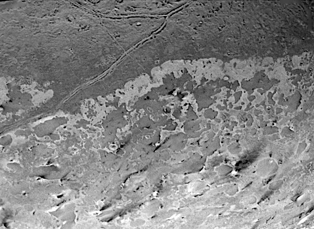
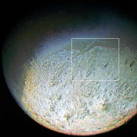
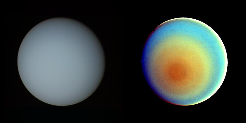
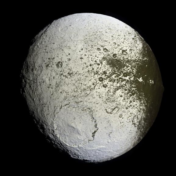
The image above, cropped and enhanced to post here, shows a portion of the southern mid-latitudes of Triton, Neptune’s largest moon, as Voyager-2 made its closest pass at a distance of about 25,000 miles. The photo to the right, cropped and reduced, shows a more global view to provide some context, with the box indicating the approximate area covered by the upper image. It was taken when Voyager-2 was on approach, at a distance of about 330,000 miles. The top picture captures several dozen black plumes that appear to vent material from below. From the caption:

The plumes originate at very dark spots generally a few miles in diameter and some are more than 100 miles long. The spots which clearly mark the source of the dark material may be vents where gas has erupted from beneath the surface and carried dark particles into Triton’s nitrogen atmosphere. Southwesterly winds then transported the erupted particles, which formed gradually thinning deposits to the northeast of most vents.

It is possible that the eruptions have been driven by seasonal heating of very shallow subsurface deposits of volatiles, and the winds transporting particles similarly may be seasonal winds. The polar terrain, upon which the dark streaks have been deposited, is a region of bright materials mottled with irregular, somewhat dark patches. The pattern of irregular patches suggests that they may correspond to lag deposits of moderately dark material that cap the bright ice over the polar terrain.

As we only have a few images of this planet, and those provided views of only about 40% of its surface, any theory that tries to explain the weird geology here is certain to be wrong to some degree.

More to come in the next few days. As much as we think we know, these pictures are going instead highlight how sparse that knowledge really is.

Intuitive Machines wins $180.4 million new NASA lunar lander contract

Intuitive Machines' Nova-D lunar lander
Click for original.

The lunar lander startup Intuitive Machines announced yesterday that it has won its fifth contract from NASA, a $180.4 million deal to place its larger upgraded Nova-D lander near the Moon’s south pole.

The IM-5 mission will target Mons Malapert, a ridge near the Lunar South Pole that offers continuous Earth visibility, stable illumination conditions, and access to permanently shadowed regions. These characteristics make the site a compelling location for future communications, navigation, and surface infrastructure.

The artist’s rendering to the right shows this Nova-D lander. What stands out immediately is its low-slung appearance. Intuitive Machines’ smaller Nova-C lander was tall (see this image), with a high center of gravity. In its only two landing attempts on the Moon it tipped over both times after touchdown. It appears the company has finally recognized the issue and reworked this new lander to make it more stable after touchdown.

This contract award appears to be part of the accelerated program by NASA administrator Jared Isaacman to land 30 unmanned rovers on the moon in three years, beginning in 2027. Mons Malapert is a plateau that Intuitive Machines second lander tipped over on. It is also the landing site for Astrobotics’ Griffin lander, as well as a candidate landing site for the first Artemis manned missions.

Note the small rover on the right in the graphic. While the mission will carry seven NASA science instrument payloads, it will also carry this commercial rover, built by Honeybee Robotics, a subsidiary of Blue Origin. As the company states above, the lander on this mission also has additional available payload capacity for more commercial customers.

Juno data suggests lightning on Jupiter is a hundred to a million times more powerful than lightning on Earth

The uncertainty of science: Using data from the orbiter Juno as it passed multiple times above a storm on Jupiter, scientists now believe lightning bolts on Jupiter could be a hundred to a million times more powerful than lightning bolts on Earth.

Juno made 12 passes over isolated storms during that period, and was close enough on four of them to measure microwave static from lightning. The flashes averaged three per second during these passes; on one flyover, Juno detected 206 separate pulses of microwave radiation. Of a total of 613 pulses measured, Wong calculated that the power ranged from about that of a lightning bolt on Earth to 100 or more times the power of an Earth bolt. Because he compared Earth lightning emissions at one radio wavelength to Jupiter lightning emissions at a different wavelength, there’s some uncertainty in the comparison, Wong cautioned. Based on one study of lightning radio emissions on Earth, Jupiter’s bolts could have been a million times more powerful than those on Earth.

Lots of uncertainty and assumptions in these conclusions, but they are not only not surprising, they fit earlier data collected before Juno.

Changes to the Crab Nebula after a quarter century

The Crab Nebula, changes after a quarter century
For original images go here and here.

Using the Hubble Space Telescope, astronomers have obtained a new high resolution image of the Crab Nebula, and by comparing it with earlier Hubble images taken in 1999/2000 have been able to track the continuing expansion and evolution of this supernova remnant over a period now covering almost a quarter century.

The supernova itself became visible on Earth in 1054, though it actually erupted about 6,500 years earlier, as the Crab Nebula is 6,500 light years away. In the 25 years Hubble has been tracking the remnant’s expansion astronomers estimate it is expanding at about 3.4 million miles per hour.

[William Blair of Johns Hopkins University] noted that filaments around the periphery of the nebula appear to have moved more compared to those in the center, and that rather than stretching out over time, they appear to have simply moved outward. This is due to the nature of the Crab as a pulsar wind nebula powered by synchrotron radiation, which is created by the interaction between the pulsar’s magnetic field and the nebula’s material. In other well-known supernova remnants, the expansion is instead driven by shockwaves from the initial explosion, eroding surrounding shells of gas that the dying star previously cast off.

The new, higher-resolution Hubble observations are also providing additional insights into the 3D structure of the Crab Nebula, which can be difficult to determine from a 2D image, Blair said. Shadows of some of the filaments can be seen cast onto the haze of synchrotron radiation in the nebula’s interior. Counterintuitively, some of the brighter filaments in the latest Hubble images show no shadows, indicating they must be located on the far side of the nebula.

A movie showing the changes between these two images can be seen here. It is worth your while to take a look. These optical images will be further enhanced as the Webb Space Telescope gathers infrared data.

Growing damage to the wheels of the Curiosity Mars rover

Close-up of the wheel in the worst condition
Images cropped and reduced to post here. For the original images go here and here.

Survey of wheels

Every few months or so the Curiosity science team uses one of the rover’s cameras to do a survey of the rover’s wheels to track their condition. Since early in the mission they had found the wheels were not holding up as well as expected as they rolled over the rough terrain in Gale Crater and on Mount Sharp, and so they take great care in how they move the rover as well as review the wheels regularly.

A year ago it had appeared that the damage to one particular wheel had increased, to a point where its outer section might even break off.

Yesterday the science team did another survey, as shown in the picture to the right.

The two photos above (found here and here) focus on one particular wheel of that survey, which I suspect is the same wheel that was the focus of last year’s post. After taking the first image on the left the team moved Curiosity so that the other side of the wheel could be photographed. As you can see, the damage is extensive, so much so that it is possible the wheel could collapse entirely in the not-to-distant future.

It also looks like another wheel is beginning to see similar damage (see here and here), though not yet as extreme.

The good news is that Curiosity has six wheels, and that it can continue to travel even with the loss of one or maybe two wheels. It also appears that future terrain might not be so rocky.

The bad news is that this wheel damage is likely the one problem that will likely end the mission, possibly sooner than anyone would like. And from these photographs, that end might be sooner rather than later.

Canada cancels small lunar rover that was to fly on Firefly’s Blue Ghost lander in ’29

Even as Canada has increased its government space spending in Europe and in Canada — mostly it appears to prop up bureaucracies or failing businesses — its space agency has at the same time cancelled its first lunar rover project, scheduled to brought to the south pole of the Moon by a Firefly Blue Ghost lander in 2029.

As part of its 2026-2027 departmental plan, the Canadian Space Agency (CSA) has cancelled its ambitious lunar rover mission. The lunar rover was announced in 2022. It would have been Canada’s first rover, built by Canadensys, and hitching a ride to the moon on a commercial launch vehicle built by a private U.S. company, Firefly Aerospace.

…The principal investigator of the mission, Gordon Osinski, a planetary geologist from Western University, said that he found out about a month ago, and that he was “devastated” by the news.

Note that this rover was hardly “ambitious.” It was a small unmanned rover comparable to similar rovers deployed by India, Japan, and others, mostly aimed at testing the engineering for later larger rovers.

The real issue however is how this decision illustrates Canada’s leftist government misplaced priorities. Increasingly it appears it is canceling actual space research or planetary missions and shifting the money to other uses, either European projects or bureaucracies in Canada or failing Canadian businesses.

Private mission to Apophis gets another customer, two student-built landers

Apophis' path past the Earth in 2029
A cartoon (not to scale) showing Apophis’s
path in 2029.

The orbital tug startup Exlabs has signed up a second payload customer to fly on its private ApophisExL mission to rendezvous with the potentially dangerous asteroid Apophis when it makes its April 13, 2029 close fly-by of the Earth.

ExLabs has announced its partnership with Japan’s Chiba Institute of Technology (ChibaTech) and its Planetary Exploration Research Center (PERC) to send university-led payloads to the surface of asteroid Apophis during its rare near-Earth flyby in 2029. ApophisExL is the world’s first commercial deep-space rideshare and is supported by mission design and operations collaboration with NASA’s Jet Propulsion Laboratory (JPL) operated by Caltech.

Under the leadership of planetary scientist and PERC Director, Dr. Tomoko Arai, ChibaTech students and researchers are developing two landing payloads to be deployed on the asteroid’s surface.

An Australian satellite startup, Fleet Space Technologies, had already signed on to fly a mapping instrument on ApophisExL.

Though the press release at the link calls this private mission “a new model,” using private enterprise rather than relying on the government for doing planetary missions, it actually harks back to the way things were done in the U.S. before World War II, when the private sector did most of this pure research. In fact, as late as the 1960s there was at least one company, American Science and Engineering, doing the first X-ray astronomical observations flying suborbital rockets. It later won contracts from NASA and other agencies to help build several later orbiting X-ray telescopes.

Over time the government space agencies became dominant, so that most of this design work was either done by them or by universities, with private companies relegated to the roles of minor subcontractors.

This new model is simply an extension of the capitalism model that is taking over the entire space industry, shifting power and ownership from big, expensive, and inefficient government programs to small, cheap, and economical private missions. Those space agencies can still do missions, but they do it by buying payload space on these private missions.

Below is a list of the missions going to Apophis in 2029:
» Read more

Uranus: one glimpse and that was forty years ago

Uranus as seen by Voyager-2, natural colors on left, false color on right
Uranus as seen by Voyager-2, natural colors on left, false color on right. Click for original.

I close today our week-long tour of Voyager-2’s fly-by of Uranus in January 1986 with three cool images, the two images of the planet itself above and a close-up of its rings. All three illustrate that though Voyager-2 gave us our first very good first close-up view of this distant world, it also gave us only a tiny glimpse, very superficial and lacking in any larger context.

The two images above were taken on January 17, 1986 when Voyager 2 was till 5.7 million miles away, on approach.

The picture at left has been processed to show Uranus as human eyes would see it from the vantage point of the spacecraft. The picture is a composite of images taken through blue, green and orange filters. The darker shadings at the upper right of the disk correspond to the day-night boundary on the planet. Beyond this boundary lies the hidden northern hemisphere of Uranus, which currently remains in total darkness as the planet rotates. The blue-green color results from the absorption of red light by methane gas in Uranus’ deep, cold and remarkably clear atmosphere.

The picture at right uses false color and extreme contrast enhancement to bring out subtle details in the polar region of Uranus. Images obtained through ultraviolet, violet and orange filters were respectively converted to the same blue, green and red colors used to produce the picture at left. The very slight contrasts visible in true color are greatly exaggerated here. In this false-color picture, Uranus reveals a dark polar hood surrounded by a series of progressively lighter concentric bands. One possible explanation is that a brownish haze or smog, concentrated over the pole, is arranged into bands by zonal motions of the upper atmosphere. The bright orange and yellow strip at the lower edge of the planet’s limb is an artifact of the image enhancement. In fact, the limb is dark and uniform in color around the planet.

The third cool image below of Uranus’s rings was taken just after the closest approach, when Voyager-2 was in Uranus’s shadow and looking back at its rings from a distance of 142,000 miles.
» Read more

SLS/Orion have begun 12-hour trip from VAB to launchpad

Artemis-2 mission flight path
The Artemis-2 flight path. Click for full animation.

NASA engineers today began the long and slow 12-hour trip of the SLS rocket from the Vehicle Assembly Building (VAB) to the launchpad in preparation for a targeted April 1, 2026 launch date of this Artemis-2 mission around the Moon.

NASA’s Artemis II SLS (Space Launch System) rocket and Orion spacecraft slated to send four astronauts around the Moon began rolling to Launch Pad 39B at 12:20 a.m. EDT on Friday, March 20. Rollout operations at the agency’s Kennedy Space Center in Florida were delayed earlier in the day due to high winds in the area.

The trek to the pad is expected to take up to 12 hours, as NASA’s crawler-transporter 2 carefully carries the rocket on top of the mobile launcher approximately 4 miles along the crawlerway.

The launch will send four astronauts on a ten-day mission swinging around the Moon and back to Earth, using a questionable heat shield and a life support system not yet been tested in space. On the first unmanned Artemis-1 mission around the Moon in 2022, the shield experienced far more damage than predicted, with large chunks breaking off. NASA engineers think they understand why this happened, and have decided that they can mitigate the problem by using a less stressful flight path upon return into Earth’s atmosphere.

They don’t really know if this is so, but they hope so. As for the life support system, the plan is to remain in a high Earth orbit for the mission’s first day to test it. If it has problems then, the crew will be able to return to Earth somewhat quickly. If it has problems after heading to the Moon, however, that won’t be possible.

If a private company tried to convince NASA to do this mission with these issues, the agency would say “Hell no!” It is proceeding because, like the Challenger and Columbia failures, it is a NASA-built project and politics and schedule have superseded safety and good engineering procedures

Engineers regain contact with Proba-3’s Coronagraph probe

The Proba-3 mission
The Proba-3 mission. Click for original.

A month after all contact was lost with the Coronagraph probe of Europe’s two-spacecraft Proba-3 solar observatory, engineers have regained contact with it this week, and have been able to place it in safe mode in preparation for re-establishing science operations.

After more than a month of silence, ESA’s ground station in Villafranca, Spain, received telemetry from the Coronagraph spacecraft. Telemetry is a package of data sent by a spacecraft including information on its temperature, voltages, and health of onboard systems.

The Coronagraph is now in safe mode and stable, and the mission team and operators are running health checks on the spacecraft to understand if any parts of it have been damaged.

The spacecraft’s solar panel is facing the Sun, powering the essential electronics on board, and charging the battery with the remaining power.

Before it can resume observations engineers need to get the spacecraft back up to operating temperature after a month without power.

As shown in the graphic to the right, the Coronograph satellite is the heart of this mission. It records the data, available because the Occulter blocks the Sun from view so that the corona, the Sun’s atmosphere, can be seen. It is almost a miracle that it has survived that month, and can soon resume observations.

Scientists compile catalog of the 69 known rocky exoplanets in the habitable zone

Graph of the 45 most habitable known exoplanets
Credit: Gillis Lowry / Pablo Carlos Budassi.
Click for original at full resolution.

Scientists reviewing the more than 6,000 exoplanets so far discovered have now compiled a detailed catalog describing the 69 known rocky exoplanets that are also in the habitable zone.

The graph to the right, cropped and reduced to post here, shows the 45 exoplanets most likely to be habitable, with the amount of energy they get from their star measured relative to that of Earth and the Sun (shown center top). You can read their paper here. From the press release:

The researchers pinpointed 45 rocky worlds that may support life in the habitable zone, and another 24 in a narrower 3D habitable zone that makes a more conservative assumption of how much heat a planet can take before it loses its habitability.

They include some famous exoplanets, including Proxima Centauri b, TRAPPIST-1f and Kepler 186f, as well as others that are not as well known, such as TOI-715 b. The most interesting planets of those listed, according to the authors, are TRAPPIST-1 d, e, f and g, which are 40 light-years from Earth, as well as LHS 1140 b, which is 48 light-years away. Whether these planets could have liquid water depends in part if they can hold an atmosphere.

The worlds that get light from their stars most similar to what modern Earth receives from the Sun are the transiting planets TRAPPIST-1 e, TOI-715 b, Kepler-1652 b, Kepler-442 b, Kepler-1544 b and the planets Proxima Centauri b, GJ 1061 d, GJ 1002 b, and Wolf 1069 b, which make their stars wobble.

The paper includes tables listing the best exoplanets that do transits of their stars, the best with the oldest estimated ages, and the best for testing the limits of the habitable zone itself. As the researchers say in their abstract:

The resulting list of rocky exoplanet targets in the HZ will allow observers to shape and optimize search strategies with space- and ground-based telescopes – such as the James Webb Space Telescope (JWST), Extremely Large Telescope (ELT), Habitable Worlds Observatory (HWO), and Large Interferometer For Exoplanets (LIFE) – and design new observing strategies and instruments to explore these worlds, addressing the question of the limits of exoplanet surface habitability.

In other words, the focus of exoplanet research is now shifting from simply finding these planets to studying them directly, with the potentially habitable worlds listed above the most interesting of all. Astronomers might not find alien life or civilizations on these worlds, but at a minimum they will be doing the first preliminary scouting for humanity’s the first interstellar missions, with the Trappist-1 solar system appearing to head the list.

Uranus’s moon Oberon, of which we know little

Uranus' five biggest moonsThe historically known moons of Uranus. Click for original NASA press release.

Oberon, as seen by Voyager-2
Click for original image.

Today we finish our week-long tour of the five largest moons of Uranus, all discovered by astronomers before the start of the space age, and imaged successfully if not very completely by Voyager-2 when it did its fly-by of the planet on January 24, 1986. The gallery of these moons above was taken by the spacecraft when it was on approach, still about three million miles from Uranus, and shows them in order from the innermost on the left to the outermost on the right. They are also scaled to show their relative sizes. To see Voyager-2’s close-up images of the four inner moons, posted earlier this week, go here, here, here, and here.

The picture to the right, cropped slightly to post here, is Voyager-2’s only high resolution image of Oberon, the outermost moon of this group. From NASA’s press release:

This Voyager 2 picture of Oberon is the best the spacecraft acquired of Uranus’ outermost moon. The picture was taken shortly after 3:30 a.m. PST on Jan. 24, 1986, from a distance of 410,000 miles. The color was reconstructed from images taken through the narrow-angle camera’s violet, clear and green filters.

The picture shows features as small as 7 miles on the moon’s surface. Clearly visible are several large impact craters in Oberon’s icy surface surrounded by bright rays similar to those seen on Jupiter’s moon Callisto. Quite prominent near the center of Oberon’s disk is a large crater with a bright central peak and a floor partially covered with very dark material. This may be icy, carbon-rich material erupted onto the crater floor sometime after the crater formed. Another striking topographic feature is a large mountain, about 6 km (4 mi) high, peeking out on the lower left limb.

Oberon is about 946 miles in diameter, making it the tenth-largest moon in the solar system. Because of the quickness of Voyager-2’s fly-by, it could get no closer images, and none of the planet’s nightside. Thus, only 40% of the surface has been photographed, and at not very high resolution.

Later spectroscopy from Hubble and other telescopes suggests there is water ice on the surface. Other data suggests Oberon may have a liquid underground ocean, but that conclusion is highly uncertain. Other than these vague facts and the image to the right, we essentially know almost nothing about this moon. Like Titiania, Uranus’s largest moon, Voyager-2’s data merely gave us a tantalizing glimpse, and that glimpse is now forty years old. No other mission has been there since, and none is planned in the near future.

Tomorrow, to summarize this tour, I will outline further what little we know of Uranus and its moons

Scientists: Shadowcam images suggest there is little water in permanently shadowed lunar craters

Shadowcam-LRO mosaic
The floor of Shackleton Crater showing no obvious ice deposits,
as seen by Shadowcam, imposed on a Lunar Reconnaissance Orbiter
image. The black cross marks the south pole. Click for original image.

In a new paper published yesterday, the science team for the low-light Shadowcam instrument on South Korea’s lunar orbiter Danuri confirmed their earlier conclusion from 2024, that there appears to be far less water ice than expected in the permanently shadowed lunar craters near the Moon’s south pole. From their abstract:

We used the high-reflectance and forward-scattering optical properties to search for water ice in lunar PSRs [permanently shaded regions]. We found no evidence of widespread water ice in PSRs at abundances above the detection limit of 20 to 30 wt % but could not rule out widespread low-content water ice. A few small locations with both high reflectance and forward-scattering behavior were observed, which could be consistent with >10 wt % ice.

And from their conclusion:

Our manual examination of ShadowCam radiance images that cover all lunar PSRs suggests either that most of the lunar PSRs lack surface ice exposures or that their ice concentration is below the detection limit, approximately 20 to 30 wt % on the basis of the visible reflectance enhancement, which aligns well with previous ShadowCam findings. Only a few candidate high-reflectance anomalies were seen, which, if they are water ice, is consistent with previous sparse detections of lunar surface water ice.

There is still a chance there is water ice in these permanently shadowed craters, but it appears once again that if it exists, it will likely require processing to extract it from the soil, and there won’t be that much available regardless.

These results are not conclusive, but they do suggest that the south pole of the Moon will not be as ideal a location for a lunar base as previously imagined.

Tantalizing Titania, Uranus’s largest moon

Uranus' five biggest moonsThe historically known moons of Uranus. Click for original NASA press release.

Titania as seen by Voyager-2
Click for original image.

This week’s tour of the five largest moons of Uranus continues today with a look at the highest resolution picture taken Uranus’s largest moon, Titania, when Voyager-2 did its fly-by of the solar system’s seventh planet on January 24, 1986. The image to the right, cropped and reduced to post here, was taken from about 229,000 miles, and can only resolve objects bigger than eight miles across. From the press release:

Titania is the largest satellite of Uranus, with a diameter of a little more than 1,000 miles. Abundant impact craters of many sizes pockmark the ancient surface. The most prominent features are fault valleys that stretch across Titania. They are up to 1,000 miles long and as much as 45 miles wide. In valleys seen at right-center, the sunward-facing walls are very bright. While this is due partly to the lighting angle, the brightness also indicates the presence of a lighter material, possibly young frost deposits. An impact crater more than 125 miles in diameter distinguishes the very bottom of the disk; the crater is cut by a younger fault valley more than 60 miles wide. An even larger impact crater, perhaps 180 miles across, is visible at top.

Two or three other images were taken by Voyager-2, but they don’t provide any significant additional information. All told the spacecraft was only able to see about 40% of Titania’s surface.

Subsequent research using a variety of orbiting telescopes have suggested there is water ice and carbon dioxide on the surface. This data also hints of the presence of a very very thin atmosphere. These results however are quite uncertain.

As with Uranus’s other moons Miranda, Ariel, and Umbriel that I highlighted earlier this week, the Voyager-2 data merely gives us a taste of what’s there. Forty years later we have learned almost nothing more about these distant worlds.

Tomorrow we look at Oberon. I will then follow-up the next day with a look at what we don’t know about Uranus and its moons.

Scientists detect the five chemicals that make up DNA/RNA inside Ryugu samples

Ryugu's northern hemisphere
Ryugu as seen by Hayabusa-2 shortly before it grabbed
samples from the surface. Arrow indicates planned touchdown
site.

Scientists studying the samples brought back from the asteroid Ryugu by Japan’s probe Hayabusa-2 have found therein a full set of the five fundamental chemicals that make up either DNA or RNA: adenine, guanine, cytosine, thymine and uracil. From the paper’s [pdf] abstract:

Organic molecules delivered from extraterrestrial materials may have played a key role in supplying building blocks for life on Earth. Here we report all five canonical nucleobases—purines (adenine and guanine) and pyrimidines (cytosine, thymine and uracil)—in samples returned from the C-type asteroid (162173) Ryugu by JAXA’s Hayabusa2 mission and compare the results with data from similar extraterrestrial material.

Ryugu samples contain nearly equal amounts of purines and pyrimidines, whereas Murchison is enriched in purines and Bennu and Orgueil in pyrimidines. Samples from Ryugu, Bennu and Orgueil, which have a similar mineralogy and elemental composition, show purine-to-pyrimidine ratios negatively correlating with ammonia.

These observations indicate that the nucleobases in these samples may have formed via a shared pathway depending on the physicochemical environment of the respective parent bodies. The detection of diverse nucleobases in asteroid and meteorite materials demonstrates their widespread presence throughout the Solar System and reinforces the hypothesis that carbonaceous asteroids contributed to the prebiotic chemical inventory of early Earth.

In other words, the data from these samples suggests that the formation of life on Earth was greatly aided by the deposition of these carbon molecules from asteroids onto the Earth.

At the same time, some caution must be exercised. At present we only have samples from three asteroids, one of which (Orgueil) was obtained shortly after it crashed on Earth. It will take a much larger census of many in-space asteroids to confirm this hypothesis.

Solar scientists: We finally think we know the location of the Sun’s dynamo

The Sun's interior
NASA graphic used in the press release and
annotated to post here.

The uncertainty of science: Using three decades of data gathered during the last three solar cycles, scientists now think they have finally determined the location of the Sun’s dynamo in its interior, at a transition point about 125,000 miles below the surface called the tachocline. From the abstract of their paper [pdf]:

The exact location of the solar dynamo remains uncertain–whether it operates primarily in the near-surface shear layer, throughout the entire convection zone, or near the tachocline – a region of sharp transition in the solar rotation, located at the base of the convection zone, approximately 200,000 km [125,000 miles] beneath the surface. Various studies have supported each of these possibilities.

…Our analysis reveals that the gradient of rotation displays ‘butterfly’–like behavior near the tachocline, which is similar to the magnetic butterfly diagram at the surface. This result supports the idea that the solar dynamo has a deep-seated origin, likely operating either near the tachocline or throughout the convection zone, thereby disfavoring the recent scenario of a shallow, near-surface dynamo. This finding may also have important implications for understanding how stellar dynamos operate in general. [emphasis mine]

Even though scientists have known for more than a century that the Sun’s eleven-year cycle of flipping the polarity of its magnetic field is the fundamental cause of the sunspot cycle, they actually know very little about the dynamo that causes that magnetic field, as this study implies. They not only don’t have any understanding of the fundamental processes that creates that dynamo or causes it to flip polarity every eleven years, they still aren’t entirely sure where it is located within the Sun.

Thus, the highlighted sentence above is one large understatement. Of course knowing the dynamos location will have “important implications for understanding stellar dynamics.” This study is a first good stab at the problem, but it also shows us how little we actually know.

Remember this when anyone tells you “the science is settled” about climate change. The Sun is the number one influence on the Earth’s climate, and its solar cycle appears to be an important factor in that influence. Until we have a better understanding of the Sun, its magnetic field, and the dynamo that creates it, no climate prediction will be worth anything. Such predictions will be all guesswork, and likely put forth for political reasons.

Voyager-2’s only close-up image of Uranus’s moon Umbriel

Uranus' five biggest moonsThe historically known moons of Uranus. Click for original NASA press release.

Umbriel as seen by Voyager-2
Click for source.

Today’s cool image continues our tour of the five largest moons of Uranus, as seen by Voyager-2 in 1986 during its close-up visit. The family portrait above, taken from more than three million miles away during Voyager-2’s approach, shows the relative sizes of those five moons as well as their location relative to Uranus, with Miranda in the closest orbit and Oberon the farthest. I have already posted close-ups from Miranda and Ariel. Today’s image moves us outward to Umbriel.

The image to the right is Voyager-2’s best picture. In fact, it is really Voyager-2’s only close-up image, and as you can see, it is not that close or sharp. I have not reduced it at all. This is how NASA released it. From the NASA press release:

The southern hemisphere of Umbriel displays heavy cratering in this Voyager 2 image, taken Jan. 24, 1986, from a distance of 346,000 miles. This frame, taken through the clear-filter of Voyager’s narrow-angle camera, is the most detailed image of Umbriel, with a resolution of about 6 miles.

Umbriel is the darkest of Uranus’ larger moons and the one that appears to have experienced the lowest level of geological activity. It has a diameter of about 750 miles and reflects only 16 percent of the light striking its surface; in the latter respect, Umbriel is similar to lunar highland areas. Umbriel is heavily cratered but lacks the numerous bright-ray craters seen on the other large Uranian satellites; this results in a relatively uniform surface albedo (reflectivity). The prominent crater on the terminator (upper right) is about 70 miles across and has a bright central peak.

The strangest feature in this image (at top) is a curious bright ring, the most reflective area seen on Umbriel. The ring is about 90 miles in diameter and lies near the satellite’s equator. The nature of the ring is not known, although it might be a frost deposit, perhaps associated with an impact crater. Spots against the black background are due to ‘noise’ in the data.

This lone picture of Umbriel by Voyager-2 illustrates even more starkly the very sparse data we have of Uranus and its moons. Voyager-2 is the only spacecraft to ever visit this planet, and it only did a quick fly-by, just long enough to give us this one dim snapshot view. It is forty years later, and no other missions have flown there, nor is any planned in the near future. There are proposals, but none are yet approved.

Modeling says the Small Magellanic Cloud passed through the Large Magellanic Cloud 200 million years ago

Illustration of collision of Magellanic clouds
Click for original graphic.

According to new computer modeling, some astronomers now believe that a collision between the Small Magellanic Cloud (SMC) and the Large Magellanic Cloud (LMC) 200 million years ago best explains the chaotic movement of the stars in the former.

The SMC contains more mass in gas than in stars. Gas cools, contracts under gravity and settles into a rotating disk, the same process that shaped the spinning plane of our solar system. But when researchers, including those at University of Arizona, previously measured the motion of the SMC’s stars using the Hubble Space Telescope and the Gaia satellite of the European Space Agency, the SMC’s stars were not orbiting around the galaxy’s center the way stars in most galaxies do.

The possible reason, Rathore said, is a collision. A few hundred million years ago, the SMC crashed directly through the LMC’s disk. The LMC’s gravity disrupted the SMC’s internal structure and sent its stars into random, disordered motion. Also, the LMC’s gas applied a tremendous amount of pressure to the SMC’s gas and destroyed its gas rotation.

The graphic to the right illustrates that collision, based on the computer modeling. It appears the Small Magellanic Cloud’s passage through the Large Magellanic Cloud acted to shake the smaller cloud apart, spreading its stars and gas across a wider space.

You can read the paper here [pdf]. There is of course a great deal of uncertainty in these results, but they add weight to the general theory that galaxy formation is strongly impacted by such collisions. As the scientists note in the conclusion of their paper, “The SMC gives a front row view of group processes driving dramatic morphological and kinematic transformations.”

The first Artemis lunar landings might not go to the Moon’s south pole

It appears from remarks recently by one NASA official, that while the south pole remains the agency’s main lunar base target, it is now looking into other landing options in order to make those first manned landing less risky and easier and quicker to achieve.

Amit Kshatriya, NASA Associate Administrator was very vague in his statement, but nonetheless this was what it appears he was saying:

We have opened up the, I would say, the performance specification for the early landing missions in as many ways as we can, in terms of different lunar orbits we want to take, or different other constraints … to make it as agile as possible, to recognize performance limitations in some of the machines we have and let our providers tell us, hey, if you took these constraints out of the way, how could we go faster? So we’re going to do that.

The agency’s administrator, Jared Isaacman, is also pushing to quickly begin sending a lot of unmanned landers to the south pole by next year. Thus, under this plan, we might actually find out first whether there really is water in those permanently shadowed craters, before committing our manned lunar base to this location.

This new approach makes a great deal of sense, especially since the data that has looked into those craters has been very inconclusive, some positive and some negative.

Continuing our tour of Uranus’ five biggest moons: Ariel

In preparing my cool image last week focused on the best Voyager-2 image of Uranus’ moon Miranda, I came to a realization that was somewhat startling. Voyager-2 is the only time a human spacecraft has gotten close to Uranus, and it was only close for a few days. Thus, the data and images it obtained of the gas giant and its moons is remarkable more sparse than I had ever realized.

You see, when these images were first released in 1986 they were exciting because they gave us that first look. Suddenly, a light was shined on something that had always been shrouded in darkness. It was a flood of data that needed processing.

It is now forty years later. No spacecraft has been there since, and thus we have gotten no more close-up information about Uranus or its moons. Data from Hubble and Webb has helped increase our knowledge of the planet itself, but of the moons nothing really new has been gleaned from this distance.

Uranus' five biggest moons

And so, to highlight how little we know, for the rest of this week I am going give my readers a tour of the few images Voyager-2 gave us of Uranus’ five biggest moons, the five that early astronomers had discovered prior to the space age and shown in the five pictures above, taken by Voyager-2 as it was approaching Uranus from a distance of about three million miles. They are, in order going from closest to farthest from Uranus, Miranda, Ariel, Umbriel, Titania and Oberon, with the images above designed to show their approximate relative sizes.

I already highlighted the strange, patchwork surface of Miranda last week, the smallest of these moons. Below is a mosaic made from the four highest resolution images of 720-mile-wide Ariel, the next out from Uranus, taken from a distance of about 80,000 miles.
» Read more

Astronomers discover a super-Earth-sized exoplanet covered by a molten ocean of lava

Using the Webb Space Telescope astronomers think they have identified a super-Earth-sized exoplanet, dubbed L98-59d and orbiting a red dwarf star about 35 light years away, that is covered by a very deep molten ocean of lava.

Their results reveal that the mantle of L98-59d is likely molten silicate (similar to lava on Earth), with a global magma ocean extending thousands of kilometres beneath. This vast molten reservoir allows the planet to store extremely large amounts of sulphur deep inside its interior, over geologic timescales. The magma ocean also helps L98-59d to retain a thick hydrogen-rich atmosphere containing sulphur-bearing gases such as hydrogen sulphide (H2S). Normally, this would be lost to space over time, due to X-ray radiation produced by the host star.

You can read the peer-reviewed paper here [pdf]. This planet is part of a three-planet solar system, all of which transit the face of the star, allowing for excellent observations of their make-up. L98-59d is the outermost of the three.

This is the first molten exoplanet yet detected, though it is likely not the last. As new better telescopes come on-line both on Earth and especially in space, the ability to make more detailed observations of the thousands of exoplanets so far identified is certain to reveal many more strange objects, some of which will be probably far stranger than we can yet imagine.

New telescope array in Chile is financed entirely by private funds

One of Mothra's 30 mounts
One of Mothra’s 30 mounts. Click for original.

Capitalism in space: A new ground-based telescope array in Chile, dubbed Mothra, is being built using only private financing, and is being designed to map the faint hydrogen hidden between the galaxies and thus produce a more precise map of the universe.

MOTHRA is being built at Obstech / El Sauce Observatory in Chile. The telescope’s construction started in the spring of 2025 and it is expected to become fully operational by the end of 2026. By fusing its many images together digitally, the array of [30 mounts totaling] 1,140 telephoto lenses will be the equivalent of a single 4.7-meter diameter lens. It will be the world’s largest all-lens telescope, with capabilities that are unmatched by any other telescope on Earth or in space.

The funding comes mostly from a donation by British billionaire Alex Gerko, who has apparently donated millions to numerous similar research projects.

This is the right future for science research, and was the way things were done in the U.S. until World War II. Stop depending on the government, which often has political concerns that warp research and always does things inefficiently. Get the private sector, especially rich individuals, to back projects, because they will require the work to be done well, and will care personally about its success.

Terran Orbital wins contract to build cubesat to go to Apophis with ESA’s Ramses probe

Apophis' path past the Earth in 2029
A cartoon (not to scale) showing Apophis’s
path in 2029.

The satellite company Terran Orbital, owned by Lockheed Martin, has won a contract from the European Space Agency (ESA) to build a cubesat to fly with its Ramses probe that will launch in 2028 and rendezvous with the potentially dangerous asteroid Apophis when it makes its very close fly-by of the Earth on April 13, 2029.

The CubeSat is named after Italian scientist Paolo Farinella and is backed by the Italian Space Agency. After successfully completing the Critical Design Review in January 2026, Tyvak International [a subsidiary of Terran Orbital] will begin the implementation phase, with launch currently planned for 2028.

…Operating aboard the RAMSES spacecraft, developed by OHB Italia, the Farinella CubeSat will be one of two spacecraft deployed to explore the asteroid’s subsurface using low-frequency radar. The satellite will also carry Horus, an optical instrument that acts as both a science imager and navigation camera, and Vista, a dust detector previously flown on the Milani CubeSat from ESA’s Hera mission.

Apophis is estimated to be about 1,200 feet across. When it does its fly-by in ’29 it will get within 20,000 miles of the Earth, dipping within the orbits used by geosynchronous satellites. It will then pass within 60,000 miles of the Moon. At its closest it will for a short time be visible to the naked eye.

Apophis’ orbit means that it has the potential in the next century or so to impact the Earth. This particular fly-by is significant because the Earth/Moon’s gravity will change the asteroid’s path in an unpredictable manner that could either increase or decrease that impact possibility on future fly-bys. And we won’t know until after the fly-by is complete.

Miranda, the smallest of Uranus’ spherical moons

Miranda as seen by Voyager-2
Click for original image.

Cool image time! The image to the right, reduced and sharpened to post here, was created from photographs taken on January 24, 1986 by Voyager-2 as it made its fly-by of the gas giant Uranus. From a later 1996 release:

Miranda, roughly 300 miles in diameter, exhibits varied geologic provinces, seen in this mosaic of clear-filter, narrow-angle images from Jan. 24, 1986. The images were obtained from distances of 18,730 to 25,030 miles; resolution ranges from 1,840 to 2,430 feet. These are among the highest-resolution pictures that Voyager has obtained of any of the new “worlds” it has encountered during its mission.

On Miranda, ridges and valleys of one province are cut off against the boundary of the next province. Probable compressional (pushed-together) folded ridges are seen in curvilinear patterns, as are many extensional (pulled-apart) faults. Some of these show very large scarps, or cliffs, ranging from 1,600 feet to 3 miles in height — that is, higher that the walls of the Grand Canyon on Earth.

This is really the only close look we have of this distant world. The other hemisphere remains a mystery, as it was in darkness when Voyager-2 zipped past. And though some of the individual shots that make up this mosiac are more detailed, they don’t provide that much more information.

Nonetheless, to my uneducated eye Miranda looks like a ball of thick molasses that some giant stirred a bit as gravity forced it to settle into its spherical shape. In this case the molasses is likely a mix of ice and other materials, not yet fully identified. The result is a tiny misshapen planet with some of the roughest topography known in the solar system, including one 12-mile high cliff face (the white streak at the image bottom) thought to be the highest in the solar system.

We don’t yet have a true understanding of the geological processes that formed this strange landscape, nor will we have until we have a lot more data, including a global map of the entire surface. And that won’t come until a spacecraft is sent there to look more closely. Right now no such mission is in the works. No NASA missions have been funded, though several have been proposed. And a Chinese mission was apparently canceled last year.

China to begin construction of its Mars sample return spacecraft

China’s state-run press today announced it is about to begin construction of its Mars sample return spacecraft, Tianwen-3, set for launch in 2028.

Based on the announcement, that date seems very unlikely.

China’s mission to retrieve samples from Mars will advance to the flight model development phase within this year, Liu Jizhong, chief designer of the Tianwen-3 mission, said on Thursday. Building on the preliminary technical research and demonstrations, the mission has achieved breakthroughs in key technologies. The engineering team is now focused on developing prototypes, Liu, also a national legislator, told reporters.

The Mars sample return mission is scheduled for launch around 2028, with the goal of returning no less than 500 grams of Martian samples to Earth by around 2031. [emphasis mine]

They only have two years to get the spacecraft built, and it involves “an orbiter, a returner, a lander, an ascender, and a service module.” While China is basing this mission’s design on its successful Chang’e lunar sample return missions, returning samples from Mars is significantly more challenging. The ascent vehicle will have a much greater gravity to overcome, and doing a robotic rendezvous and docking in orbit around another planet millions of miles from Earth has never even been tried.

Cubesat ultraviolet space telescope achieves first light

Sparcs first light images
Click for original images.

A new low-cost cubesat-sized NASA ultraviolet space telescope, dubbed Sparcs, has achieved first light, successfully taking both near- and far-ultraviolet false-color images of a nearby star.

Those images are to the right, with the top the far-ultraviolet image and the bottom in the near ultraviolet. From the press release:

Roughly the size of a large cereal box, SPARCS will monitor flares and sunspot activity on low-mass stars — objects only 30% to 70% the mass of the Sun. These stars are among the most common in the Milky Way and host the majority of the galaxy’s roughly 50 billion habitable-zone terrestrial planets, which are rocky worlds close enough to their stars for temperatures that could allow liquid water and potentially support life.

The question astronomers will try to answer with this telescope is whether the solar activity on these stars is high enough to prevent life from forming in the star’s habitable zone. Because these stars are dim and small, the habitable zone is quite close to the star, which means solar activity has a higher impact on the planet. We don’t yet have sufficient data to determine the normal activity of such stars. Sparcs will provide a good first survey.

It will also demonstrate the viability of such small low-cost cubesats for this kind of research. If successful expect more such telescopes, some of which are likely to be private, like Blue Skies Space’s Mauve optical telescope already in orbit.

A close-up of the dark side of Saturn’s moon Iapetus

Iapetus' equator ridge
Click for original image.

Cassini's first global close-up of Iapetus
Click for original image.

Today’s cool image is a double-header! The picture above, cropped to post here, was taken on September 10, 2007 during Cassini’s fly-by of Saturn’s moon Iapetus, taken from approximately 1,000 miles above the surface. It looks at the dark side of this two-toned planet (see yesterday’s cool image). As the moon’s rotation is tidally locked so that one side always faces Saturn, one hemisphere always leads while the other always trails. For some reason still unexplained, the leading hemisphere is covered with an almost pitch-black material, while the trailing hemisphere is bright and very white, its icy surface quite visible.

For context, to the right is a global image of that dark side taken during Cassini’s first fly-by of Iapetus on December 31, 2004. This picture highlights the long ridge that runs along the planet’s dark hemisphere’s equator that was the focus of the close-up image above. From the 2005 press release:

The most unique, and perhaps most remarkable feature discovered on Iapetus in Cassini images is a topographic ridge that coincides almost exactly with the geographic equator. The ridge is conspicuous in the picture as an approximately 12 miles band that extends from the western (left) side of the disc almost to the day/night boundary on the right. On the left horizon, the peak of the ridge reaches at least 8 miles above the surrounding terrain. Along the roughly 800-mile-length over which it can be traced in this picture, it remains almost exactly parallel to the equator within a couple of degrees. The physical origin of the ridge has yet to be explained. It is not yet clear whether the ridge is a mountain belt that has folded upward, or an extensional crack in the surface through which material from inside Iapetus erupted onto the surface and accumulated locally, forming the ridge.

Iapetus itself has a diameter of about 900 miles, so this ridge essentially crosses most of the dark hemisphere.

The 2007 press release did not provide enough information to pinpoint exactly where along that ridge the close-up is located, but no matter. Both images make very clear what we are looking at.

Have astronomers spotted the collision of two exoplanets around a Sunlike star?

Changes in the infrared

Using data from a number of orbiting space telescopes, astronomers think they have detected the collision of two exoplanets, producing debris that for about 200 days variably blocked the light from the system’s star.

The images to the right come from figure 1 of their published paper [pdf], showing changes in the infrared as detected by the WISE space telescope. From the press release:

The star, named Gaia20ehk, was about 11,000 light-years from Earth near the constellation Pupis. It was a stable “main sequence” star, much like our sun, which meant that it should emit steady, predictable light. Yet this star began to flicker wildly. “The star’s light output was nice and flat, but starting in 2016 it had these three dips in brightness. And then, right around 2021, it went completely bonkers,” said Tzanidakis, a doctoral candidate in astronomy at the University of Washington. “I can’t emphasize enough that stars like our sun don’t do that. So when we saw this one, we were like ‘Hello, what’s going on here?’”

The cause of the flickering had nothing to do with the star itself: Huge quantities of rocks and dust — seemingly from out of nowhere — were passing in front of the distant star as the material orbited the system, patchily dimming the light that reached Earth. The likely source of all that debris was even more remarkable: a catastrophic collision between two planets.

…“The infrared light curve was the complete opposite of the visible light,” Tzanidakis said. “As the visible light began to flicker and dim, the infrared light spiked. Which could mean that the material blocking the star is hot — so hot that it’s glowing in the infrared.”

A cataclysmic collision between planets would certainly produce enough heat to explain the infrared energy. What’s more, the right kind of collision could also explain those initial dips in light.

The data suggests the collision occurred at an orbit comparable to that of the Earth’s, and took more than a half a year to largely dissipate.

All of this is a reasonable hypothesis based on the data available. Though there is a lot of uncertainty in this conclusion, the researchers considered other explanations, such as variability in the star itself, and found them less credible.

NASA’s Van Allen Probe A burns up over the Pacific

We didn’t all die! Van Allen Probe A, one of two NASA spacecraft launched in 2012 to study the Van Allen radiation belts that circle the Earth, yesterday burned up harmlessly over the Pacific ocean as expected.

Both Van Allen probes have been defunct since around 2019, when they ran out of fuel. Van Allen Probe B weighed about 1,300 pounds, so some pieces probably reached the ocean. Had it returned over land it did carry the small risk of doing harm.

The orbit of the other probe, Van Allen Probe B, is expected to decay sometime around 2030. Like its twin, it is heavy enough that some parts will survive re-entry. It is therefore a prime target for a demonstration mission proving the technology for removing space junk safely and under control. NASA should put out a request for bids to the many orbital tug companies that now exist to do exactly that, as it is NASA’s responsibility to make sure this spacecraft re-enters the atmosphere safely.

Iapetus: Saturn’s ying-yang moon

Iapetus as seen by Cassini in 2007
Click for original image.

Cool image time! The image to the right, reduced and sharpened to post here, was taken on September 10, 2007 by the Saturn orbiter Cassini as it made its first close fly-by of the moon Iapetus, from a distance of about 45,000 miles.

Iapetus, about 912 miles in diameter, is one of the strangest objects in the solar system. As it orbits Saturn, its leading hemisphere is very dark, covered with almost pitch black material, while its trailing hemisphere is very bright. This picture captures a bit of both, with the dark leading hemisphere visible along the right edge.

In many places, the dark material–thought to be composed of nitrogen-bearing organic compounds called cyanides, hydrated minerals and other carbonaceous minerals–appears to coat equator-facing slopes and crater floors. The distribution of this material and variations in the color of the bright material across the trailing hemisphere will be crucial clues to understanding the origin of Iapetus’ peculiar bright-dark dual personality.

There are several theories to explain the planet’s strange ying-yang two-tone coloration. One suggests it is material thrown off by other Saturn moons that Iapetus sweeps up. Other theories suggest the planet’s orbit itself causes the two hemispheres to have different temperatures, allowing material to sublimate off the dark side and to the bright side.

No theory is presently accepted. Nor does any explain the data fully.

Tomorrow I’ll post a most intriguing close-up of Iapetus taken by Cassini during that 2007 fly-by.

1 2 3 290