Zhurong found Mars drier than expected and less eroded than the Moon

According to a new paper, Chinese scientists using data from their Zhurong Mars rover have found little or no evidence of water in the immediate underground, while also finding the surface less eroded than the surface on the Moon.

A layer of regolith covers the surface of Mars, which is the result of geologic processes that occurred over millions to billions of years. Compared to the observations from satellites, the Zhurong rover of China’s first Mars mission (Tianwen-1) had a closer look at the properties of the regolith layer in the explored region within southern Utopia Planitia. There is evidence that the exposed materials might be related to aqueous activities. Local landforms on the surface suggest the possible presence of buried volatiles, like water ice. The radar instrument (RoPeR) on board the rover can expose subsurface structures and the dielectric properties of the regolith layer at high-resolution, to assess their composition. The loss tangent results suggest that water ice is not the main component of the local martian regolith at some depth. The scattering distribution of radar profile along the traveling path and heterogeneous subsurface features show more diverse surface processes and weaker space weathering effects on Mars than those on the airless Moon.

Since Zhurong landed in the equatorial regions, its data about the lack of water simply confirmed other data from orbit and from other rovers/landers. Though there are features even here that suggest the presence of water, that water made those features a long time ago, and is now gone.

The data suggesting the regolith is less eroded than the Moon, however, is a surprise, and counter-intuitive.

Zhurong data shows very weak magnetic field at landing site

Using data accumulated by Zhurong while it was still rovering on Mars, Chinese scientists have determined that the weak Martian magnetic field at Utopia Basin where the rover landed was very weak, much weaker than expected.

Results from NASA’s Mars’ lander InSight, which landed about 2,000 km southeast of Zhurong, have revealed that the crustal magnetic field at InSight’s landing site was an order stronger than that inferred from orbital measurement. Measurements from Zhurong, however, revealed the opposite result, with the average intensity an order less than that inferred from orbit.

The weak field suggests that the crust under Utopia Basin was never magnetized, or was demagnetized by some large later impact.

Meanwhile, no word on Zhurong itself, which either remains in hibernation or has died due to lack of power caused by the dusty Martian winter.

Zhurong: Small polygons on light curved dunes indicate regular atmospheric water interaction

Zhurong's full journey on Mars

A paper published this week in Geophysical Research Letters by the science team for China Zhurong Martian rover has revealed the discovery of small polygon cracks on the surface of the many curved light-colored small dunes found in the region where Zhurong landed, suggesting the possibility of relatively recent water activity between the atmosphere and the dune surfaces.

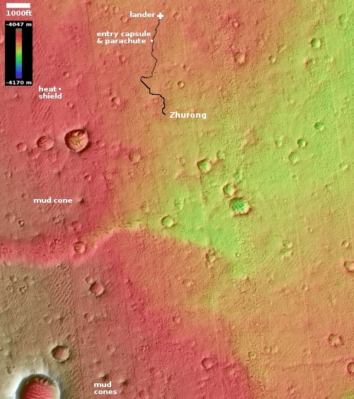
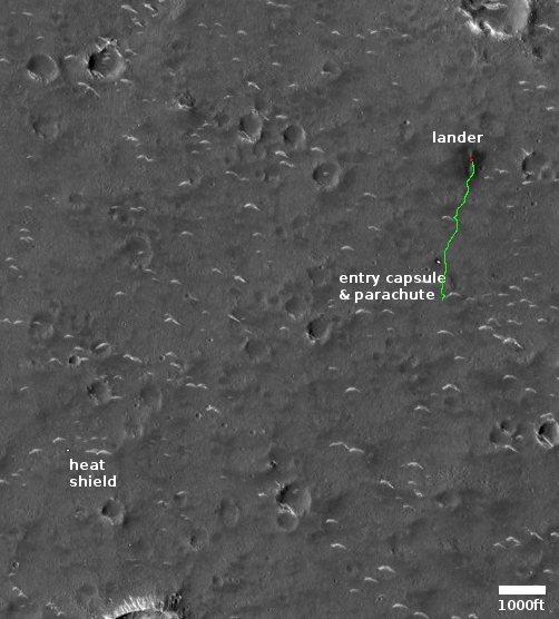
Those dunes, dubbed transverse aeolian ridges (TARs) by the science team, are the many light curves visible in the labeled Mars Reconnaissance mosaic to the right. The blue arrows indicate Zhurong’s path south from its landing spot at the top and ending near the bottom of the picture after traveling about 1,400 feet.

According to the paper, the TARs were formed by the prevailing winds over many eons, coming first from the north and then from the northwest. The edges of the ridges, being smaller, are pushed ahead quicker, thus creating the curved shape. The polygons were small, never larger than 4 inches in size, with five to six sides. The scientists theorize that they were formed when atmospheric water interacted with the dune crust, causing fractures “due to temperature/moisture changes or deliquescence/dehydration cycling of salts”. This process could be slow or fast, and could actually be occurring in relatively recent times, as the scientists say it requires only a little water in the atmosphere.

More likely however we are seeing evidence of water from the past, from tens of thousands to several million years ago.

Zhurong meanwhile remains in hibernation, and might never come out of that condition. Orbital images indicate that its solar panels are dust-covered, the result of the heavy winter dust storm season. The project team however is hopeful that with time and the arrival of Martian summer the dust will be blown off and they can reactivate the rover. This hope however entirely depends on the arrival of a dust devil acoss the top of Zhurong, a random event that cannot be predicted. With both the Spirit and Opportunity rovers, such events happened regularly, allowing those missions to last years instead of only 90 days. With InSight it never happened, and the lander died after two-plus years on Mars.

Zhurong’s future fate thus remains unknown, but not promising at this moment.

China’s continued silence about Zhurong suggests Mars rover is dead

Zhurong's ground-penetrating radar data
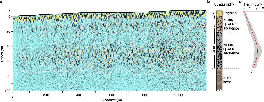
The data from Zhurong’s ground-penetrating radar instrument.

Overview map
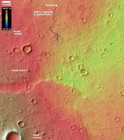
Zhurong’s final location is somewhere in the blue circle.

China’s continued silence about Zhurong — which should have come out of hibernation sometime in late December-early January — suggests the Mars rover did not survive the Martian winter, which this year was also lengthened near the end by some additional dust storms.

Zhurong went into hibernation in May 2022, at the start of winter, with plans to awaken in December. Like the helicopter Ingenuity and the lander InSight, it depends on solar power, and had to contend with a very relatively severe winter dust season this Martian year.

Even though the Chinese press has loudly touted Tianwen-1’s first two years in Mars orbit, it has made little or no mention of Zhurong, a silence that is deafening.

The silence is also foolish, because China has nothing to be ashamed of concerning Zhurong. The mission was only supposed to operate for 90 days. Instead it lasted more than a year, traveling much farther than planned. Most important, the data from its radar instrument (shown above) showed that, at this location at 25 degrees north latitude, there is no underground ice to a depth of 260 feet. That data confirmed that the Martian equatorial regions below 30 degrees latitude are very dry, with any underground ice existing rarely if at all. The icy regions above 30 degrees latitude do not appear to extend much farther south than that latitude.

China’s Mars orbiter and rover in trouble

Yesterday we reported a tweet from Scott Tilley that suggested engineers were having trouble establishing a communications link with China’s Mars orbiter Tienwen-1.

Today it appears that communications with China’s rover Zhurong have also not resumed following its winter hibernation from May until December.

The Post independently confirmed with two sources on Thursday that the rover should have resumed running by now, but no contact has been established.

Though Zhurong’s solar panels can be tilted to kick dust from them, during hibernation this is apparently not possible. Because the winter dust season this year was especially bad (killing InSight for example), it is possible that Zhurong experienced the same fate.

Zhurong had a 90 day mission, and instead lasted a year. Moreover, tt was never expected to survive a Martian winter. The achievement thus remains grand.

As for the Tienwen-1 orbiter, it would be a much bigger failure if communications cannot be re-established. China without question expected this orbiter to operate for years, even functioning as a communications link for later landers/rovers. Its loss will force a revision of later plans.

Radar data from Zhurong finds no ice to a depth of 260 feet

Zhurong's ground-penetrating radar data

Overview map

Chinese scientists today finally published their results from the ground-penetrating radar instrument on their Mars rover Zhurong, revealing that to a depth of 260 feet (80 meters), it detected no clear signal of water ice.

Figure 2 of their paper, posted above, summarizes their results. It shows the radar profile to 328 feet (100 meters) depth along Zhurong’s route, as shown in the map to the right, with the last bit of its recent travels ending somewhere in the blue circle. From the paper:

Our low-frequency radar imaging profile shows radar signals within the depth range of 0–80 m (Fig. 2a), precluding the existence of a water-rich layer within this depth range as the existence of water would strongly attenuate the radar signals and diminish the visibility of deeper reflections. The estimated low (less than 9) dielectric permittivity (Fig. 2c) further supports the absence of a water-rich layer as water-bearing materials typically have high (greater than 15) dielectric permittivity.

We further tested this assessment with thermal considerations by conducting a heat conduction simulation based on available thermal parameters estimated from previous studies (Methods). Our thermal simulation results … show that the Zhurong landing area has an annual average temperature of around 220K in the RoPeR detection depth range, which is much lower than the freezing point of pure water (273K), and also lower than the eutectic temperatures of typical sulfate and carbonate brines, but slightly above those of perchlorate brine systems. This observation suggests that the shallow subsurface of the Zhurong landing area could not stably contain liquid water nor sulfate or carbonate brines, consistent with the radar imaging result.

The data suggests that below the surface topsoil layer, the regolith, there are two distinct layers of material that the scientists interpret as possible evidence of past catastrophic floods. That conclusion however is very very uncertain. The main take-away is that in the northern lowland plains of Utopia Planitia at 25 degrees north latitude, where Zhurong landed, Mars is definitely a dry desert, with no water close to the surface.

This data also suggests that if you establish a colony anywhere in Mars’ dry equatorial regions within 30 degrees latitude of the equator, you will likely have to travel north or south a considerable distance to get to easily accessible ice. The global map of Mars below shows the regions where ice is most evident, north and south of 30 degrees latitude.
» Read more

Zhurong goes into hibernation

Overview map

According to a report today in China’s state-run press, the team running its Zhurong Mars rover have placed it into a hibernation mode in order to sit out the Martian winter.

To tackle the dust storms and low-temperature challenges, the Chinese rover went into dormancy on Wednesday. It is expected to wake up and resume work in December when the dust clears and Mars enters its spring season, the administration said in a statement.

The rover sits somewhere in the blue circle in the map to the right, created using elevation data and images from Mars Reconnaissance Orbiter (MRO). This region is about 25 degrees north latitude, so though it is in the dry equatorial regions of Mars, it still gets very cold in winter, down to -180 degrees Fahrenheit at night. Furthermore, the increased winter dust storms block the light from the Sun, which reduces the available power the rover’s solar panels can produce.

Chinese engineers have apparently adapted the hibernation techniques they use on the Moon with their Yutu-2 rover to place Zhurong in hibernation.

Zhurong travels another 1,300 feet

Overview map

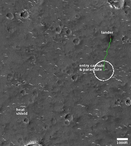
UPDATE: After emailing this post to Alfred McEwen of the Lunar & Planetary Laboratory in Arizona, he responded to correct an error in my image. The MRO photo was taken when Zhurong had already traveled about half the 1,300 feet listed in the Chinese article below, thus making my original circle about two times too large.

I have corrected its size. It now shows the correct maximum distance Zhurong could have driven since that MRO picture was taken on March 11th.

Original post:
——————–
According to a short report yesterday in China’s state-run press, Zhurong has traveled another 1,300 feet on Mars since it was photographed from orbit on March 11, 2022 by the high resolution camera on Mars Reconnaissance Orbiter (MRO).

The report provided no information at all about the rover’s path. The map to the right shows Zhurong’s position as of March 11th, with the blue circle marking the maximum distance it could have moved since then according to this report. Based on China’s earlier vague statements, it is likely the rover has moved to the south, though even that covers a lot of possibilities.

The report did say this however:

Mars is about to enter the winter season, during which night temperatures will drop below minus 100 degrees Celsius, with a high probability of sandstorms. Martian winters last an equivalent of six Earth months.

Because Zhurong uses solar panels, it relies on the Sun for power. With coming of winter and more sandstorms, it thus faces the risk of limited solar power. As its nominal mission was only supposed to last three months, not a Martian year of 24 months that includes a winter, it will be interesting to see if it can survive that season.

The story also added that Yutu-2 has now traveled about 3,875 feet on the Moon, but added nothing else.

The journey so far of China’s Zhurong Mars rover

Zhurong's journey on Mars, as seen by MRO
Click for full image.

Elevation map and wider overview
Click for full image.

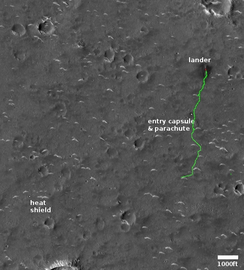
Cool image time! The science team for the high resolution camera on Mars Reconnaissance Orbiter (MRO) today released a new orbital photo that shows the entire journey on Mars of China’s Zhurong rover, since it landed in May 2021. That image, reduced to post here, is to the right. From the caption, written by Alfred McEwen of the Lunar & Planetary Laboratory in Arizona:

This HiRISE image, acquired on 11 March 2022, shows how far the rover has traveled in the 10 months since it landed.

In fact, its exact path can be traced from the wheel tracks left on the surface. It has traveled south for roughly 1.5 kilometers (about 1 mile). This cutout highlights the rover and the rover’s path (with contrast enhanced to better reveal the tracks).

The white curves that the rover has apparently been inspecting as it moved south are called megaripples, mid-size sand dunes from three to six feet in height that are generally found to be inactive, though not always. From a recent report about Zhurong’s findings:

“The examples Zhurong has visited appear very bright-toned in satellite images taken from orbit, and the team thinks that this is because the megaripples are covered with a layer of very fine dust,” says Matt Balme at the Open University, UK, who wasn’t involved in the analysis. “This means these features are probably currently inactive, as any present-day windblown sand would tend to remove the dust.”

That report used data from the rover’s first sixty days on Mars, after it had passed its first megaripple and had just reached the parachute and backshell. It does not include any later data in the past eight months, as Zhurong rolled past another nine megaripples and several small craters.

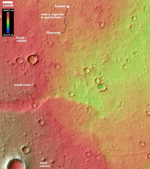
It also doesn’t include any data obtained as the rover skirted the wide apron that surrounds the large depression in the lower left. That depression looks like a crater at first glance, but because it appears to be on top of a mound it could instead by an old pitted cone. There are a lot of these cones in this region of the northern lowland plains of Mars, and planetary scientists really want to know whether they were formed from erupting ice, lava, or mud.

The Chinese have so far not released any data on what they have found in these later travels. We shall have to wait for further published papers.

The wider elevation overview map to the right, first published on August 24, 2021 and cropped and annotated to post here, shows Zhurong’s future potential geological targets to the south. The cone to the southwest as well as the nearest scarp to the south are probably the rover’s primary goals.

Though the released results have hinted that the geology here was shaped by both wind and water, direct evidence for water has not been found, or revealed by the Chinese. Zhurong has a radar sensor that could detect evidence of near surface underground ice, if it was there. As far as I know at this point, no results from that instrument have as yet been published.

Mars Express successfully relays data from Zhurong to Earth

The European Space Agency’s Mars Express orbiter has successfully been used to relay data from China’s Zhurong Mars rover to Earth and then to China.

In November, ESA’s Mars Express and CNSA’s Zhurong teams carried out a series of experimental communication tests in which Mars Express used this ‘in the blind’ mode to listen for signals sent to it by the Zhurong Rover.

The experiments culminated in a successful test on 20 November. “Mars Express successfully received the signals sent by the rover, and our colleagues in the Zhurong team confirmed that all the data arrived on Earth in very good quality.” says ESA’s Gerhard Billig.

Apparently, normal communications would first involve “handshake” communications between the two, but that requires communications frequencies Zhurong does not use. Mars Express instead had to grab the data on the blind. The test was a success, which means the ESA will likely act as another communications relay for Zhurong, in addition to China’s Tianwen-1 orbiter, as the rover’s mission on Mars continues.

Zhurong’s continuing travels on Mars

Zhurong overview map
Click for original map.

This past week the Chinese press released a new but limited update on the status of both its Mars orbiter Tianwen-1 and its Mars rover Zhurong.

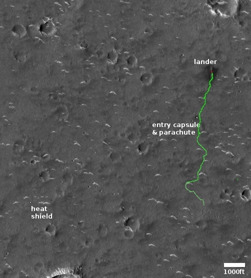
The map to the right uses as its background a high resolution picture from Mars Reconnaissance Orbiter. I have superimposed Zhurong’s route in green. You can get an idea of how far the rover has traveled since resuming communications with Earth in late October by comparing this map with the one I posted then. After stopping at a small sand dune (the crescent-shaped white features), it curved around to head to the southeast towards a rough area and a trough that is thought to be filled with sediment.

Meanwhile, the orbiter has shifted its orbit, changing from one dedicated mainly as providing a communications relay between Zhurong and Earth to one that now allows it to begin a two-year photographic survey of Mars.

To supplement the resulting gaps in communications for Zhurong, China and the European Space Agency (ESA) have made their first test using ESA’s Mars Express satellite as a relay satellite. Both hope to know soon whether it worked.

In either case, Zhurong’s travels will likely be slowed somewhat due to the reduction in communications access.

China resumes communications with Zhurong Mars rover

Elevation map of Zhurong location
Click for full image.

The new colonial movement: China yesterday announced that it has regained communications with its Zhurong rover, located in the Martian northern lowland plains of Utopia Planitia.

The image to the right, cropped and annotated by me to post here, is a digital terrain map created from two high resolution photos taken by Mars Reconnaissance Orbiter (MRO). The black line shows the route Zhurong has traveled since landing in May.

According to [Chen Baichao, the chief designer of Zhurong], the rover has traveled more than 1,000 meters since it landed on Mars at the southern part of Utopia Planitia in May 2021. After the solar conjunction, it will head south to find mud volcanoes, which scientists are interested in, located about 10 km away.

American scientists had hoped Zhurong would head north to a much larger mud cone that was much closer. Their decision to head south to the smaller cones farther away tells us that they have given themselves a much more challenging mission. It also suggests they decided it will be easier to get Zhurong closer to a smaller cone.

Based on that 10 kilometer distance, it seems the Chinese are aiming for the cones near the bottom of the map. It took Zhurong three months to travel the distance shown. At that pace, to get to those small southern mud cones will likely take, at a minimum, about fifteen months. Though the ground is quite flat, the rover will either have to negotiate one small rise of about 15 feet, or detour to the east somewhat to find a less steep route.

It is also possible that they will instead head to the mud cone south of the large impact crater. It is also a small cone, is much nearer, and will not require them to get past that rise.

China resumes communications with Tianwen-1 Mars orbiter

With the Sun no longer between the Earth and Mars, China has re-established communications with its Tianwen-1 Mars orbiter.

According to the CNSA [China National Space Administration], the orbiter will enter the remote-sensing orbit of Mars in early November to carry out global detection and obtain scientific data such as morphology and geological structure, surface material composition and soil type distribution, atmospheric ionosphere, and space environment of Mars.

The orbiter will also relay the communication between the rover and Earth for the rover’s extended mission, the CNSA added.

Based on this information, full communications with the rover Zhurong will not resume until November because the orbiter needs to re-adjust its orbit.

Zhurong completes 100 days on Mars

Zhurong's loaction, August 31, 2021

The new colonial movement: In announcing today that its Mars rover Zhurong has completed 100 days on the Martian surface, the state-run Chinese press released one very low-resolution panorama taken at the rover’s new position, and a map showing its full route since landing.

The map to the right, created by placing that route on a high resolution Mars Reconnaissance Orbiter image, shows us where Zhurong presently sits as well as where it might travel next. It still appears that they are attempting to reach the heat shield used during landing, which also suggests that they are giving high priority to the engineering aspects of this mission, possibly ranking that component higher than any science they get.

If high resolution versions of that panorama are available, they are probably only available on the Chinese language sites, which makes it very difficult for a non-Chinese-speaker to find.

According to the release, the rover has now traveled just under 3,500 feet, which means it is maintaining a pace greater than 1,000 feet per month. The release also noted this fact about the rover’s upcoming travels, as well as the Tianwen-1 orbiter being used as a communications relay satellite:

The probes will experience a sun outage in mid-to-late September when the Sun is aligned with Earth and Mars, with the solar radiation interfering with the communication between the probes and ground stations. The orbiter and rover will stop working until the sun outage comes to an end.

This conjunction occurs every two years. It means there will also be a pause in data from the American rovers and orbiters. When the last conjunction occurred in September 2019, the communications shutdown lasted about two weeks.

Zhurong travels another 700 feet on Mars

Zhurong's location

According to a new update from China’s state-run press today, since the last update of its Zhurong Mars rover on July 31st, the rover has traveled just over 700 feet, for a total travel distance of about 2,624 feet, just under a half mile.

As of August 6, 2021, the rover has worked on the surface of Mars for 82 Martian days and the orbiter has been in orbit for 379 days. The two are in good condition and functioning properly.

The report provides no other real information.. I have indicated on the map to the right the range in which this travel distance could have taken Zhurong. Hopefully they will release more information soon.

The nominal mission was originally planned for 90 days. Right now it looks like the rover will easily exceed that.

Zhurong continues south, inspecting dunes

Zhurong's travels as of July 31, 2021

The Chinese science team for their Zhurong Mars rover released new images yesterday, including a map showing the rover’s present position.

The new images and location has confirmed that the white streaks seen in orbital pictures are small dunes of sand blown by the thin Martian wind.

The map to the right, created using their map but annotated and providing a wider context, shows their present location relative to the lander and surrounding terrain. So far the rover has traveled about 1,900 feet, about 1,000 feet per month. Since it seems to be operating as planned, I expect China will extend the mission once it completes its nominal three-month tour in about two weeks.

At that travel pace there is much of interest that is within the rover’s range. I expect they are heading south partly because this brings them closer to their original landing site, which is an area they probably studied at length before landing. Whether they head to the largest crater, visible only partly on the image’s south edge, remains unclear.

The nearest hill to China’s Zhurong

Pitted cone near Zhurong
Click for full image.

Cool image time! The science team for the high resolution camera on Mars Reconnaissance Orbiter (MRO) today released a pair of images the camera took on June 28, 2021 of the nearest pitted cone to China’s Zhurong rover.

The stereo anaglyph to the right, cropped and reduced to post here, allows you, with blue-red 3D glasses, to see the cone in three dimensions. Quite impressive. As noted by Alfred McEwen of the Lunar & Planetary Laboratory in Arizona in his caption,

This image completed a stereo pair of a region just west of where the Zhurong rover landed in southern Utopia Planitia.

The cutout is from a portion of the stereo anaglyph, showing an enigmatic pitted cone. Is this cone composed of sediments or volcanic materials? The sharp bright features surrounding the cone are aeolian (wind-blown) landforms.

According to McEwan, the hill itself is about 200 to 220 feet high, with the pit at its top about 60-65 feet deep.

While McEwan has told me this cone would be his primary target if he was running Zhurong, it appears the Chinese are instead heading south toward the largest nearby crater, and on the way inspecting the parachute, fairing, and heat shield discarded just prior to landing.

The mosaic below from three MRO context camera images provides a wider overview.
» Read more

New images from Zhurong on Mars

Zhurong's view north
Click for full image.

China today released three new images from its Zhurong Mars rover, showing that since their last release in late June the rover has traveled about 1,000 feet to the south to reach the parachute and backshell (or entry capsule), both released just before landing.

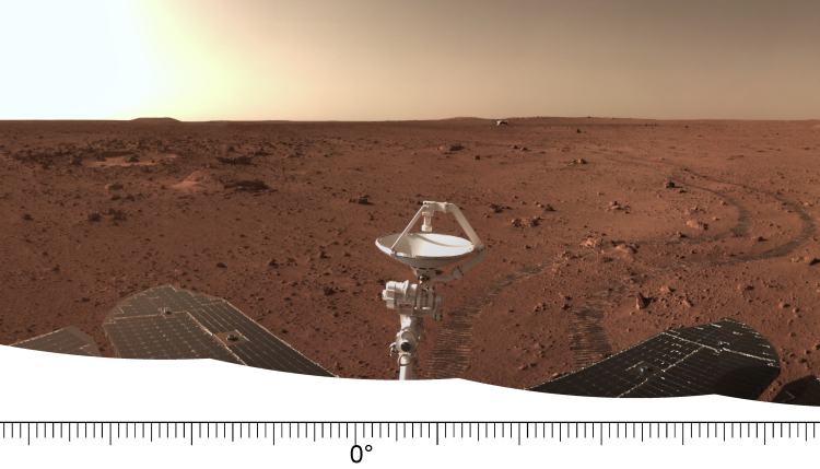
The image to the right, cropped and reduced to post here, is the color panorama from that release, looking north. According to a translation of the Chinese press release, provided at this Space.com report, the image shows:

“The complete back cover structure after aerodynamic ablation, the attitude control engine diversion hole on the back cover is clearly identifiable,”

Below is an annotated orbital picture of this location taken by Mars Reconnaissance Orbiter (MRO) in mid-June.
» Read more

Sublimating scallops on Mars

Giant scallop on Mars
Click for full image.

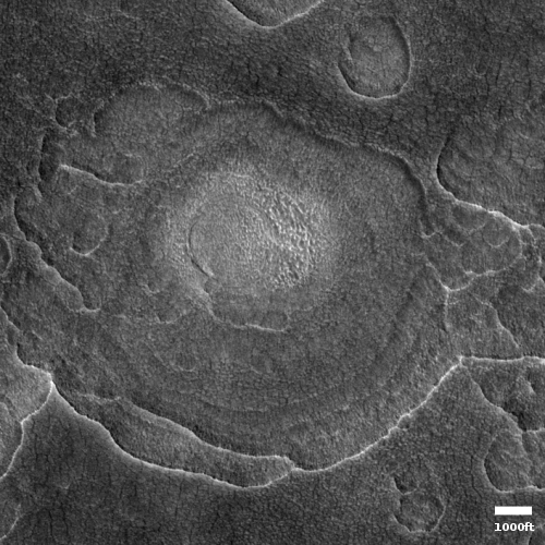
Today’s cool image, shown in a rotated, cropped, and reduced version to the right, gives us a close-up look at one of the giant scallops found in the high mid-latitudes of the northern lowland plains of Mars, specifically in Utopia Basin north of the landing sites of both Perseverance and Zhurong. In fact, this particular image is only a few miles north of one of my previous cool images, Giant scallops on Mars, posted in December 2019.

The image was taken on February 3, 2021 by the high resolution camera on Mars Reconnaissance Orbiter (MRO). While such scallops are not unusual in the mid-latitudes, their formation process is not well understood. As I noted in the 2019 post, ” scientists believe [pdf] the formation process is related to the sublimation of underground ice.”

According to [one hypothesis] scallop formation should be ongoing at the present time. Sublimation of interstitial ice could induce a collapse of material, initially as a small pit, then growing [away from the equator] because of greater solar heating on [that] side. Nearby scallops would coalesce together as can be seen to have occurred.

This hypothesis is not proven, and today’s cool image raises questions about it. Though the bright material at its center suggests exposed ice, supporting the idea that sublimation of ice near the surface created the scallop, the scallop scarps seem more extended and distinct to the south, not the north as this hypothesis proposes. Sunlight should hit the northern scarps more, which suggests they should retreat more instead of the southern scarp.

The overview map below provides the context.
» Read more

China releases more images & videos from Zhurong

Zhurong panorama looking north, June 27, 2021
Click for full image.

Overview map
Click for full image.

China today released a new panorama as well as several videos taken by its Mars rover Zhurong.

The videos show the rover’s landing as well as two short videos taken from the remote camera it had dropped off shortly after deployment from its lander, the first showing the rover moving away and the second showing it turning in place.. China also released sound recorded during that deployment, as the rover rolled down the ramps. The sound was of course enhanced, but it does allow scientists to learn something about the atmosphere of Mars.

The image above is a cropped section from the panorama. The map to the right, taken on June 11th by the high resolution camera on Mars Reconnaissance Orbiter (MRO), has been annotated by me to show the area I think is seen by this section of that panorama, looking due north. (For a higher resolution version that clearly shows the rover’s tracks since leaving the lander, go here.)

Zhurong’s travels during first three weeks on Mars

Zhurong's travels through June 11th
Click for full image.

The science team for the high resolution camera on Mars Reconnaissance Orbiter (MRO) today released a new image showing the path that China’s rover , Zhurong, has taken from its landing on May 14th through June 11th.

The photo to the right, cropped and reduced to post here, is that photo. If you look close you can see the rover’s track skirting the edge of the bright blast mark put on the surface by the lander’s engines during touchdown. Though my scale bar is approximate, it does show that in those four weeks the rover traveled about 150 to 200 feet. However, half of that distance was crossed in the five days from June 6th to June 11th (as shown by the two different MRO images at these links), which means the pace is picking up.

The rover’s nominal three-month mission ends in mid-August, only two months from now. However, none of us should be surprised if the mission gets extended for as long as the rover continues to function.

China releases more images from Zhurong

Zhurong looking north past its lander
Click for full image.

The new colonial movement: Three weeks after its Mars rover Zhurong rolled off its lander to begin its 90 day mission, China yesterday finally released the first high resolution images taken by the rover.

The images included a 360 degree panorama, taken while the rover was still sitting on the lander, an image of both the rover and lander taken by a mini-camera that was dropped from the bottom of the rover, a picture of some interesting nearby boulders to the east, and a picture looking past the lander looking north.

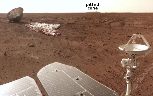
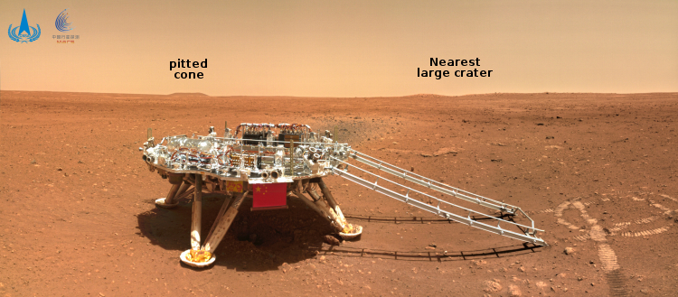
This last picture is above, reduced and annotated by me. The small flat but distinct hill to the north I think is the nearest pitted cone that could be either a mud or lava volcano. That cone is about 3.75 miles away, and though a very enticing target is probably too far away for Zhurong to reach, unless it survives for years past its planned three-month mission, as did the American rovers Spirit and Opportunity.

The closer small ridges and hills just to its right could be the east and west rims of the nearest large crater, about 650 feet wide with a distorted shape, that is visible in the high resolution orbital images taken by both Tianwen-1 and Mars Reconnaissance Orbiter (MRO). This crater is about 1,600 feet away.

Based on these images it appears that once Zhurong rolled off the lander to the east, it immediately turned to the right to move several feet south, where it turned right again to move several feet to the west until it was just to the west of the lander, where it took the picture above. During that last move it dropped the small camera behind it so that it could take the picture showing both the rover and the lander.

These maneuvers and the rover’s position south of the lander and facing west suggest they are going to head to the west, where there are some nearby smaller craters and other interesting features. Whether they eventually go north, with that pitted cone a long term goal should the rover last longer than its planned mission through the end of August, remains entirely unknown.

Zhurong finally located on Mars

Zhurong as seen by MRO
Click for full image.

Though the Chinese had earlier this week released one image taken by their Mars orbiter, Tianwen-1, showing their rover Zhurong on the surface of Mars, they did not provide any specific location information.

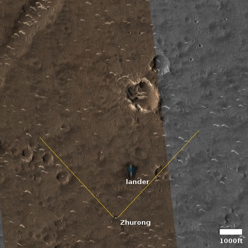
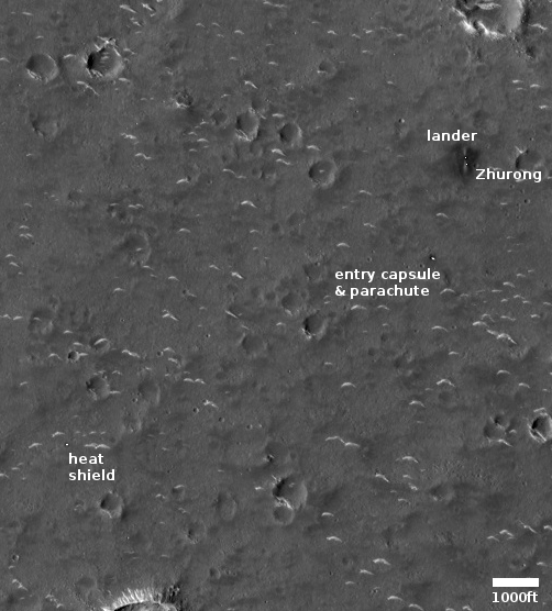
This lack has now been filled by a new high resolution image of Zhurong taken by Mars Reconnaissance Orbiter (MRO) on June 6, 2021. This image, cropped to match the Tianwen-1 image and annotated by me to post here, shows the parachute, entry capsule, heat shield, lander, and rover. I have added white dots to distinguish the rover from the lander, which indicate that since the Tianwen-1 orbital image the rover had moved south about 70 feet, suggesting it has been able to travel on the surface.

What this MRO image provides that the Chinese refused to reveal is the latitude and longitude of that landing site, which in turn tells us that the lander put down about 14 miles to the northwest of its targeted landing spot. The mosaic of MRO context camera images below show this landing spot in context with the surrounding terrain.
» Read more

China releases orbital image showing Zhurong on Mars

Zhurong on Mars
Click for original image.

China’s state-run press today released two images taken by its Tianwen-1 Mars orbiter showing its Zhurong rover on the surface of Mars.

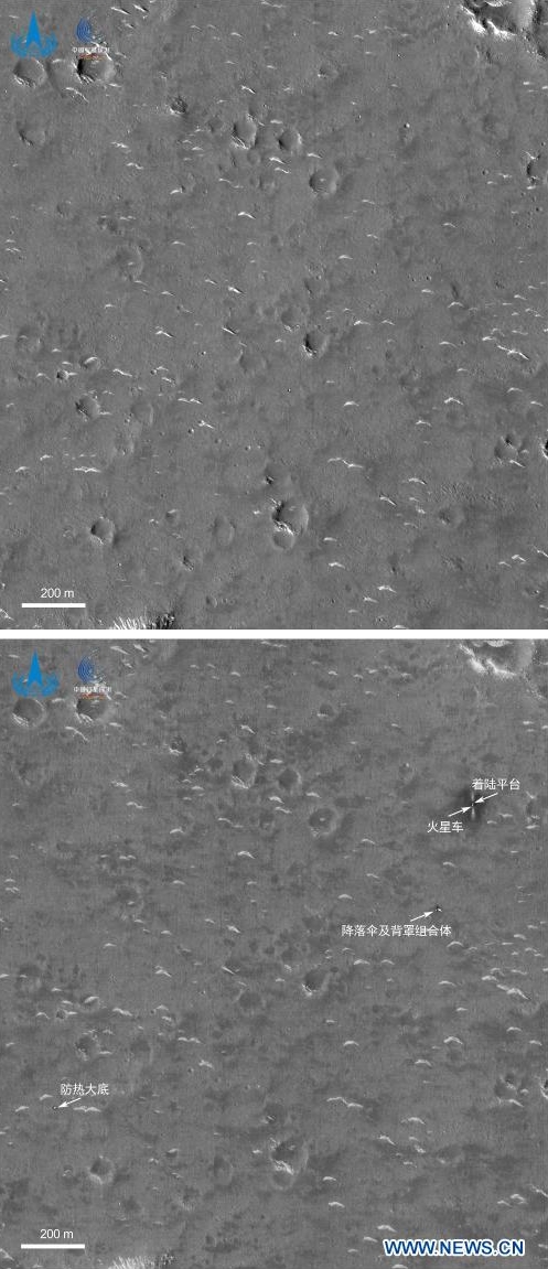
Those photos are to the right. The top shows the location prior to the rover’s landing. The bottom, taken on June 2nd, shows the rover and its landing platform, as well as its entry capsule, heat shield, and parachutes.

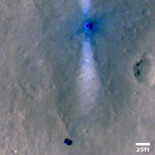
In the image, taken by a high-resolution camera installed on the orbiter of Tianwen-1 at 6 p.m. on June 2 (Beijing Time), two bright spots are visible in the upper right corner. The larger one is the landing platform, and the smaller one is the Zhurong Mars rover, the CNSA said.

…The dark area surrounding the landing platform might be caused by the influence of the engine plume during landing. The symmetrical bright stripes in the north-south direction of the landing platform might be from fine dust when the landing platform emptied the remaining fuel after landing, the CNSA said.

The bright spots in the center of the image are the back cover of the entry capsule and the parachute jettisoned during the landing. Another bright spot in the lower left of the image is the heat shield of the entry capsule, the CNSA said.

Based on the second photo, it appears that Zhurong has barely moved far from the lander since it rolled off on May 22nd.

And that’s all we really know. The Chinese press release provides no details about how well the rover is functioning, where exactly this location is on the surface of Mars, nor anything else of interest. The rover might be in the region covered by the MRO photos I posted yesterday, but if so the resolution isn’t good enough for me to find the spot. I am sure however that MRO scientists are presently carefully comparing their highest resolution version with these Tianwen-1 images to pinpoint it. They will then follow-up with their own high-resolution images of Zhurong from MRO.

The rover has a planned mission length of 90 Martian days, which runs through the end of August. How much the Chinese government will reveal about its operations and results however remains completely unknown. If it functions as planned expect science papers published in about a year. If not we will only get silence.

Mini-volcanoes (mud or lava?) near Zhurong’s Mars landing site

Mosaic of features near Zhurong's planned landing site on Mars
Click here, here, and here for full images.

Cool image time! Though we still do not know exactly where the Chinese Mars rover Zhurong landed on Mars, we have a rough idea based on the latitude and longitude numbers leaked to the Chinese press in October 2020 and were apparently confirmed by photos taken by the Tianwen-1 orbiter soon after reaching Mars. We also know Zhurong’s engineers wanted to land in the northern lowland plains dubbed Utopia Planitia, a region that is relatively flat and thus makes a safe landing spot for their first attempt to reach the surface of Mars.

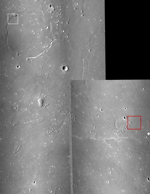
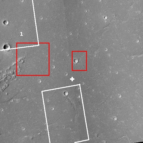
The mosaic to the right, rotated and reduced to post here, is made from three context camera images taken by Mars Reconnaissance Orbiter (MRO). The white cross on the right edge is essentially Zhurong’s leaked landing spot. The red box indicates the area covered by one of only two photos that China has released that were taken by its Tianwen-1 orbiter.

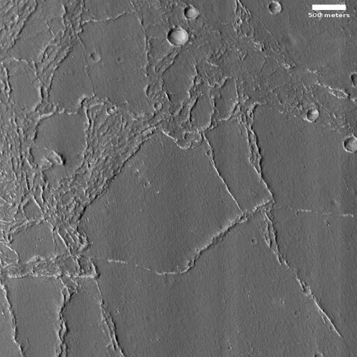
The white box in the upper left shows the area covered by today’s cool image, shown below.
» Read more

Inexplicable ridges north of China’s Mars rover

Wrinkle ridges in Utopia Planitia?
Click for full image.

Cool image time! The photo to the right, rotated, cropped, and reduced to post here, shows some unusual geology about 450 miles north of the approximate area where China’s Zhurong rover landed in the northern lowlands of Mars. It was taken on April 14, 2021 by the high resolution camera on Mars Reconnaissance Orbiter (MRO).

These scattered ridges remind me of wrinkle ridges, formed when the surface of a place shrinks. With less surface area, the extra material needs somewhere to go, and so ridges are forced up at weak points to release the pressure.

Assuming this hand-waving explanation is true, the next question would be: What causes the shrinking? The overview map below might help provide an answer.
» Read more

Zhurong rolls onto Martian surface

Zhurong's view of lander after deployment onto Martian surface

The new colonial movement: According to China’s state-run press, the Zhurong rover has successfully rolled off its lander and reached the Martian surface.

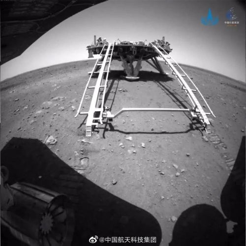
The image to the right was taken by the rover’s rear hazard avoidance camera, and shows the lander and the deployment ramps behind Zhurong.

At this moment China has released no other images of the Martian surface, nor have they revealed if they have a precise idea of where the lander actually put down on Mars. This latter information is essential for them to plan the rover’s travels over its 90-day nominal mission.

Nonetheless, it appears Zhurong is functioning perfectly. If all goes right, it will not only complete that 90-day mission but continue on for considerably longer, as have other similar small rovers on both Mars and the Moon.

1st pictures from Zhurong finally released

Zhurong's front view
Click for full image.

Zhurong's rear view
Click for full image.

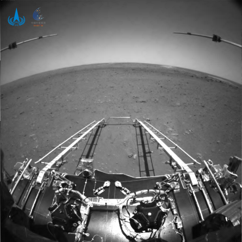
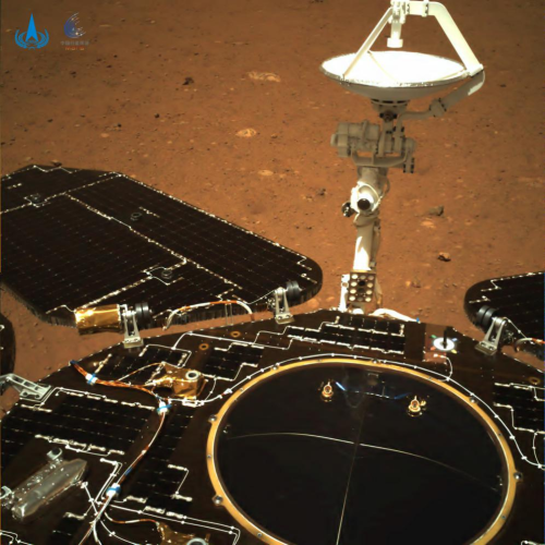
China today finally released the first images from its Mars rover Zhurong, proving that the rover landed successfully and is operating as planned. The link takes you to the website of the Chinese space agency, in Chinese. This link provides some details in English.

The two images to the right show the front and rear views from Zhurong, sitting on top of its landing. The black & white front view shows the deployed ramps that the rover will roll down when it begins it operational phase. It shows, as expected, the generally flat terrain of the northern lowlands plains of Utopia Planitia. In the distance however there appears to be distinct features, possibly the rim of a small crater. At the moment the exact location of the rover is not known, so no precise map yet exists of its surrounding terrain. This will change in the coming days as both Chinese and American scientists hone in on the rover using orbital images.

The color rear view shows that the rover’s solar panels and high gain antenna have properly deployed. While the design of Zhurong in many ways imitates the two American rovers Spirit and Opportunity (probably because China hacked into the JPL website for several years and downloaded their blueprints), it also includes several upgrades. For example, Zhurong’s solar panels unfold, providing a significantly larger surface area to gather sunlight. Both Spirit and Opportunity were somewhat hampered by the power they could obtain by their smaller solar panels. Both also experienced times when Martian dust on the panels reduced that power. Zhurong’s much larger panels will protect it better from these issues, and could allow it to survive longer on Mars.

Where is China’s Zhurong Mars rover?

Where is Zhurong?

At this moment we do not have confirmation that China’s rover Zhurong landed safely on Mars. Assuming it did, the mosaic to the right, made from two images from Mars Reconnaissance Orbiter’s (MRO) context camera, shows that landing zone, with the white cross indicating the centerpoint of the suspected landing site, as leaked to the Chinese press back in October 2020.

The red boxes are the only two images released by China that were taken by its Tianwen-1 orbiter of this landing zone. The two white boxes show the areas covered by two of the seven or so photographs taken by MRO’s high resolution camera since that location was revealed. Below is a map showing all the images MRO has taken of this location.
» Read more

Why no visual confirmation of the landing on Mars of China’s Zhurong rover?

Despite more than 48 hours having passed since China announced the successful landing of its Zhurong rover on Mars in the northern lowland plain of Utopia Planitia, no images or data of any kind has been released by that nation or its space agency.

It is very possible that this is totally expected, since they have always said they will need about a week of checkouts before they rollled the rover off the lander and begin its operations.

At the same time, China has been very very creative with providing early images for all its planetary missions. For example, within hours of landing they had released images from their Chang’e-5 lunar sample return lander. Similarly, only hours after Chang’e-4 landed on the far side of the Moon with its Yutu-2 rover China released images.

They did the exact same thing when Chang’e-3 landed in 2013 with its Yutu-1 rover.

I can’t imagine they don’t have some cameras on the Mars lander to snap pictures of the horizon or the ground directly below. They might not, but if so the lack would be truly astonishing.

It is also possible China is holding the data close for any number of political reasons, though this doesn’t make much sense since the whole political point of these planetary missions is to sell China to the world.

The more time that passes with no confirmation data, the more it will appear that something is wrong. If this conclusion is incorrect, China needs to act now to dispel these doubts.

1 2