
Exploring Arsia Mons
In November over a period of two weeks the Mars Odyssey team posted ten images of Pavonis Mons, the smallest of the aligned three giant volcanoes just to the east of Olympus Mons, the largest known volcano in the solar system. I then made all of those images available in a single link, with some analysis.
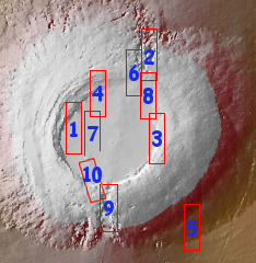
They have now done the same thing for the southernmost (and possibly the most interesting) of those three aligned volcanoes, Arsia Mons. From the first image below:
Arsia Mons is the southernmost of the Tharsis volcanoes. It is 270 miles (450km) in diameter, almost 12 miles (20km) high, and the summit caldera is 72 miles (120km) wide. For comparison, the largest volcano on Earth is Mauna Loa. From its base on the sea floor, Mauna Loa measures only 6.3 miles high and 75 miles in diameter. A large volcanic crater known as a caldera is located at the summit of all of the Tharsis volcanoes. These calderas are produced by massive volcanic explosions and collapse. The Arsia Mons summit caldera is larger than many volcanoes on Earth.
In other words, you could fit almost all of Mauna Loa entirely within the caldera of Arsia Mons.
The image on the right above is the master index, annotated by me to show the area covered by each image. The images can accessed individually below.
- 1. Northwestern caldera wall and caldera floor
- 2. Fractured north slope
- 3. Eastern rim, slumping into caldera
- 4. Northern rim, with lava tubes
- 5. Southeastern slope
- 6. Collapse features on northern rim
- 7. The caldera floor
- 8. Northeast rim and caldera floor
- 9. Collapse features on southern rim
- 10. Southern caldera floor and rim
The second and sixth images focus on the gigantic collapse features on the volcano’s northeastern slope. The ninth image focuses on the similar collapse features on the southwestern slope. All align with similar collapse features on all three aligned volcanoes. From the second image:
The three large aligned Tharsis volcanoes are Arsia Mons, Pavonis Mons and Ascreaus Mons (from south to north). There are collapse features on all three volcanoes, on the southwestern and northeastern flanks. This alignment may indicate a large fracture/vent system was responsible for the eruptions that formed all three volcanoes.
Earlier research has also shown that many of the pit craters in this area also align along this fracture zone, running from northeast to southwest. To continue the quote from the second image:
The flows of originating from Arsia Mons are thought to be the youngest of the region. This VIS image shows part of the northeastern flank of Arsia Mons. The scalloped depression are most likely created by collapse of the roof of lava tubes. Lava tubes originate during eruption event, when the margins of a flow harden around a still flowing lava stream. When an eruption ends these can become hollow tubes within the flow. With time, the roof of the tube may collapse into the empty space below. The tubes are linear, so the collapse of the roof creates a linear depression.
Some of the features in the ninth image might resemble craters, but almost certainly were not caused by impact but by lava flows leaving voids below and the ceilings collapsing into those voids. The overall northeast to southwest alignment of the fracture line as well as the three giant volcanoes themselves indicates a larger scale geological feature that spans all three large volcanoes and is likely the root cause for their existence.
The fourth and sixth images show meandering collapse features suggestive of lava tubes. Image eight has some overlap with images 2, 3, and 6, but the lighting in those areas is different so different aspects of the same features can be seen in the different images.
My big disappointment about this series of images is that they did not choose to feature any on Arsia Mons’ western slopes, the area where geology suggests past glacial activity and where water clouds are routinely seen. That area might have frozen water trapped inside its lava tubes, and mapping in detail any likely entrances to me seems a priority for future research and colonization. Moreover, it appears we have so far not found a lot of cave entrances in this area, so taking a closer look makes even more sense.
At the same time, these images all reveal collapse feature and evidence of lava tubes, all of which could have trapped water ice. Take a look at them all. You will find yourself wanting to go there to get a closer look. The images also suggest that this entire volcanic region is going to become a major water mining area when the settlement of Mars begins, even if the colonies themselves end up getting built elsewhere.

On Christmas Eve 1968 three Americans became the first humans to visit another world. What they did to celebrate was unexpected and profound, and will be remembered throughout all human history. Genesis: the Story of Apollo 8, Robert Zimmerman's classic history of humanity's first journey to another world, tells that story, and it is now available as both an ebook and an audiobook, both with a foreword by Valerie Anders and a new introduction by Robert Zimmerman.
The print edition can be purchased at Amazon or from any other book seller. If you want an autographed copy the price is $60 for the hardback and $45 for the paperback, plus $8 shipping for each. Go here for purchasing details. The ebook is available everywhere for $5.99 (before discount) at amazon, or direct from my ebook publisher, ebookit. If you buy it from ebookit you don't support the big tech companies and the author gets a bigger cut much sooner.
The audiobook is also available at all these vendors, and is also free with a 30-day trial membership to Audible.
"Not simply about one mission, [Genesis] is also the history of America's quest for the moon... Zimmerman has done a masterful job of tying disparate events together into a solid account of one of America's greatest human triumphs."--San Antonio Express-News