Review of orbital images confirms source of largest Mars quake was not an impact

Location of May quake
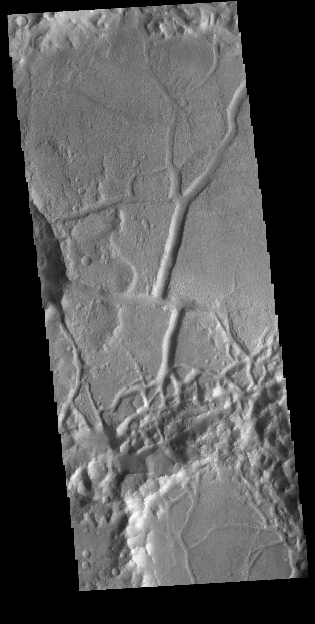
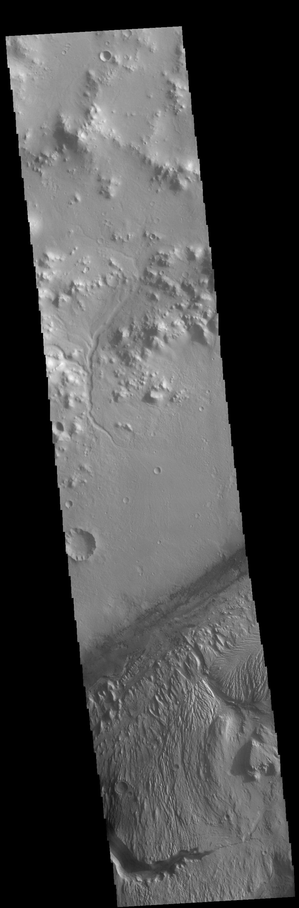
The white patches mark the locations on Mars of the largest quakes
detected by InSight. The green dotted patch marks this particular 4.7 quake.

Scientists reviewing images from several different orbiters have confirmed that the source of the largest Mars quake detected by InSight, 4.7 magnitude, was not caused by a meteorite impact and thus proves that movement in the interior of Mars is still occurring.

The quake, which had a magnitude of 4.7 and caused vibrations to reverberate through the planet for at least six hours, was recorded by NASA’s InSight lander on Wednesday 4 May 2022. Because its seismic signal was similar to previous quakes known to be caused by meteoroid impacts, the team believed that this event (dubbed ‘S1222a’) might have been caused by an impact as well, and launched an international search for a fresh crater.

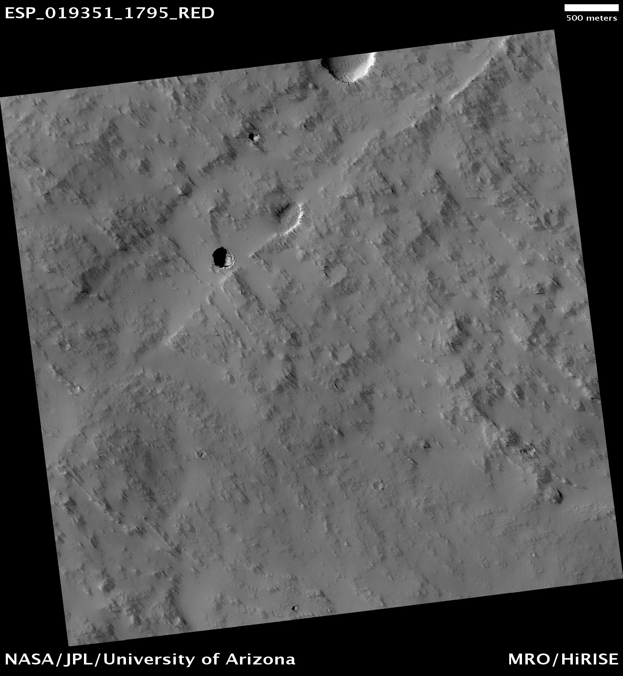
…During its time on Mars, InSight (which was co-designed by the University of Oxford) recorded at least 8 marsquake events caused by meteoroid impacts. The largest two of these formed craters around 150m in diameter. If the S1222a event was formed by an impact, the crater would be expected to be at least 300m in diameter. Each group examined data from their satellites orbiting Mars to look for a new crater, or any other tell-tale signature of an impact (e.g. a dust cloud appearing in the hours after the quake).

After several months of searching, the team announced today that no fresh crater was found.

You can read their paper here. To do the survey, the team used data from the American orbiters Mars Reconnaissance Orbiter and Mars Odyssey, and also enlisted help from scientists controlling the data from Europe’s Mars Express, China’s Tianwen-1, India’s Mangalyaan, and the United Arab Emirates’ Al-Mal.

The results suggest the quake occurred at “a dip-slip fault in the mid-crust, consistent with an origin between 18 and 28 km depth,” as stated in the conclusion of their paper. More analysis is necessary, but this result proves that the Martian interior still active enough to produce relatively large quakes..

Reassessed fuel measurements give Mars Odyssey until 2025 before it runs out

Using more refined methods for measuring the fuel left on Mars Odyssey, the oldest orbiter circling Mars at this time, engineers have determined that it will not run out until 2025, not this year as previously thought.

Mars Odyssey has been in orbit around Mars since 2001. The fuel is used by thrusters to help maintain the spacecraft’s orientation, which is mostly done by reaction wheels, or gyroscopes. We should therefore not be surprised if by 2025 engineers figure out a way to get the reaction wheels to do the whole job, when the fuel runs out.

Glaciers in the Martian south latitudes

Glaciers in Mars' southern hemisphere
Click for full image.

Most of the glacier cool images I have posted in the past few years from the high resolution camera on Mars Reconnaissance Orbiter (MRO) have shown the obvious glacial features found in the northern hemisphere in that 2,000 mile long strip of chaos terrain at about 40 degrees latitude I dub “Glacier Country.”

Today’s glacier image to the right, cropped and reduced to post here, takes us instead to the southern hemisphere, into Hellas Basin, the death valley of Mars. The picture was taken on April 8, 2021, and in the full picture gives us a myriad of examples of glacial features. The section featured to the right focuses in on what appears to be an ice covered south facing slope, which in the southern hemisphere will get the least sunlight.

Think of the last bits of snow that refuse to melt after a big blizzard. They are always found in shadowed areas, which in the southern hemisphere would be this south-facing slope.

The overview map below shows how this location, marked by the small white rectangle, is inside Hellas Basin, at a low altitude comparable to the northern lowland plains. The feature is also a comparable latitude, 43 degrees south, to the glacier country of the north.
» Read more

Slip-sliding away – on Mars

Faults on Mars
Click for full image.

Today’s cool Martian image, rotated, cropped, and reduced to post here, comes from the camera on Mars Odyssey and was taken on May 18, 2020. It shows an area on Mars where faults and cracks in the ground have caused criss-crossing depressions. In this particular case we can see that the north-south trending fissure at some point got cut in half by east-west trending fault, its northern and southern halves thus getting shifted sideways from each other. For scale the straight section of the northern canyon is about five miles long, with the sideways shift about a mile in length.

As the caption notes, “With time and erosion this region of fault blocks will become chaos terrain,” regions of canyons often cutting at right angles to each other with flat-topped mesas and buttes in between.

Now for the mystery.
» Read more

Deciphering the strange geology of Mars — or anything!

Eroding Medusae Fossae Formation ash deposits
Click for full image.

Today’s cool image is for once not taken by the high resolution camera on Mars Reconnaissance Orbiter (MRO). Instead, the image to the right, cropped and reduced to post here, was taken by Mars Odyssey on April 5, 2020, and shows the scouring and erosion caused by winds over many eons in a region dubbed Zephyria Planum. (Note that the image might fool your eye. Sunlight is coming from the east, and the rough terrain at the top is higher than the smooth plain at the bottom.)

Years ago, when I first started to rummage through the archives of images from the various Mars orbiters, I would have seen this image and posted it because I was completely baffled by what I saw, and thought that mystery made it worth showing to the public. Since then my incessant probing of research papers as well as asking a lot of questions of scientists has taught me a lot more about what scientists now surmise of the Martian geology. This greater knowledge in turn makes it possible for me to look at an image like this and immediately make a reasonable guess as to an explanation. This photo, while still containing much that is mysterious, is no longer completely baffling to me.

This willingness to ask questions and dig deeper is fundamental to all things. To have a deeper understanding and not simply guess about any subject, you always have to recognize that your assumptions are likely wrong, and that to learn anything you have to repeatedly ask what I call “the next question.” The first answer will force you to recognize that your first guesses are wrong, raise more questions, which in turn will lead to more questions, and then more questions, and so forth.

Whether I am researching Mars or early space history or politics, this rule always applies. Don’t leap to a conclusion. Think it possible you could be wrong. Ask the next question. And the next. You will repeatedly find that what you thought you knew was not correct, and in the end you will gain a deeper understanding of what is actually known about any subject, as well as what is unknown. And knowing the unknowns is probably the most important thing you can learn.

To gain a better understanding of today’s particular image, our first questions must start with context. Where is this feature on Mars? What is the surrounding history of that location? And what is already known about this place?

The location immediately reveals a great deal, as shown in the overview map below.
» Read more

Curiosity and other Mars orbiters threatened by budget cuts

The proposed budget for NASA in the Trump administrations 2021 budget request to Congress includes significant budget cuts to both Curiosity and several Mars orbiters needed to act as relay communications satellites.

The White House’s 2021 federal budget request allocates just $40 million to the mission, a decrease of 20% from the rover’s current funding. And that current funding is 13% less than Curiosity got in the previous year, said Curiosity project scientist Ashwin Vasavada, of NASA’s Jet Propulsion Laboratory (JPL) in Pasadena, California.

If the 2021 request is passed by Congress as-is, Curiosity’s operations would have to be scaled back considerably. Running the mission with just $40 million in 2021 would leave unused about 40% of the science team’s capability and 40% of the rover’s power output, which comes from a radioisotope thermoelectric generator (RTG), Vasavada said.

In addition, the proposed budget will require a 50% reduction in imaging by Mars Reconnaissance Orbiter, the end to the Mars Odyssey orbiter, and a significant but unspecified reduction in the use of the MAVEN orbiter.

I reported these facts back in March but there is no harm in noting them again.

The question is not whether there should be cuts at NASA. Considering the overall federal debt and annual budget deficit, NASA’s budget should be cut. The question is what to cut. The planetary program, probably NASA’s most successful program, is certainly not the program to cut. Instead, the Trump administration should be cutting the waste and badly run programs, like SLS, that spend billions and accomplish nothing.

If Congress and Trump did this, they could cut NASA’s total budget and still have plenty left over for the commercial manned program — including going to the Moon — and also increase the budget to the planetary program. I’ve been saying this since 2011, and nothing has happened in the past decade to change that conclusion.

Taking a look back at a Martian pit

Pavonis Mons pit
Click for full image.

The pit to the right could almost be considered the first “cool image” on Behind the Black. It was first posted on June 20, 2011. Though I had already posted a number of very interesting images, this appears to be the first that I specifically labeled as “cool.”

The image, taken by the high resolution camera on Mars Reconnaissance Orbiter (MRO), had been requested by a seventh grade Mars student team at Evergreen Middle School in Cottonwood, California, and shows a pit on the southeastern flank of the volcano Pavonis Mons, the middle volcano in Mars’ well-known chain of three giant volcanoes. A close look at the shadowed area with the exposure cranked up suggests that this pit does not open up into a more extensive lava tube.

What inspired me to repost this image today was the release of a new image from Mars Odyssey of this pit and the surrounding terrain, taken on July 31, 2019 and shown below to the right.
» Read more

The temperature on Phobos

The temperature on Phobos
Click for full image.

The Mars Odyssey science team today released false color images of the Martian Moon Phobos showing the temperature range that the spacecraft has detected, shown above in a reduced form.

The April 24, 2019 image is the first time Mars Odyssey had gotten a full moon look at the Moon. Not surprisingly, the hottest spots on the surface are at the center, at noon, with it getting cooler as one gets to the outer edges near dawn and dusk and at the poles.

Land of mesas

Ariadnes Colles
Click for full image.

Cool image time! The Mars Odyssey science team today released the image on the right, cropped and rotated to show here, of a region on Mars named “Ariadnes Colles.”

The term colles means hills or knobs. The hills appear brighter than the surrounding lowlands, likely due to relatively less dust cover.

This is certainly a place with lots of hills, or to be more precise, mesas, as many of them seem to be flat topped.

The lack of dust cover on the tops is probably because, like on Earth, the winds blow much better once you get a bit above the surface. (This is why sailing ship builders kept adding higher and higher sails to their ships, until the top sails of clipper ships rose a hundred-plus feet above the deck.) These better winds clean off the mesa tops, just as they did to the solar panels on the rovers Opportunity and Spirit several times during their long missions.

Ariadnes Colles is another example of Martian chaotic terrain. Since this region is located deep in the cratered and rough southern highlands of Mars, the erosion that created these mesas was likely not water-flows. Was it wind? Ice?

Your guess is as good as anyone’s.

Volcanic rills and lava tubes on Mars

Rills and lava tubes on Pavonis Mons

Cool image time! The image on the right, cropped somewhat to show here, was taken by Mars Odyssey of the southwestern slope of Pavonis Mons, the middle volcano of the line of three giant volcanoes located between the biggest volcano in the solar system, Olympus Mons, and the biggest canyon in the solar system, Marineris Valles. The slope goes down to the south, from the top to the bottom of the image. As noted on the image page,

The channel and nearby oval depressions are both related to the flow of lava. Narrow lava flows can create channels. The cooling of the top of the channel will form a roof over the flow, creating a tube beneath the surface. After the lava stops flowing the tube can empty, leaving a subsurface void. The roof will then collapse into the void forming the oval surface features.

I have added arrows to the image to draw your eye to the features that extend south in line with those oval depressions, eventually widening out to resemble a river delta, with the obvious rill probably indicating the lowest point in that delta.

Though the oval depressions are likely sections of a lava tube that collapsed, the features in line with those depressions suggest that the tube itself might still exist below the surface to the south, feeding into that delta where the rill meanders. It is also possible that my desire to find underground voids here, where glacier ice might possibly exist, might be skewing my conclusion. It could also be that the lava tube ended at these depressions, and what the features indicate is a wide surface flow, later embellished by the smaller flow of the meandering rill.

The mysterious chaos terrain of Mars

In one of my weekly posts last month (dated May 14th) delving into the May image release from Mars Reconnaissance Orbiter’s (MRO) high resolution camera, I featured an image of what planetary geologists have labeled chaos terrain, a hummocky chaotic terrain that has no real parallel on Earth but is found in many places on Mars.

This month’s image MRO release included two more fascinating images of this type of terrain. In addition, the Mars Odyssey team today also released its own image of chaos terrain, showing a small part of a region dubbed Margaritifer Chaos. Below, the Mars Odyssey image is on the right, with one of the MRO images to the left. Both have been cropped, with the MRO image also reduced in resolution. The full MRO image shows what the MRO science team labels “possibly early stage chaos” on the rim of a canyon dubbed Shalbatana Vallis.

young chaos in Shalbatana Vallis

Margaritifer Chaos

» Read more

Mars Odyssey looks down at Curiosity

Gale Crater

The Mars Odyssey team today released an image the spacecraft took of Gale Crater on January 16, 2018. This image, reduced in resolution, is posted on the right and captures the entire region that the rover Curiosity has been traversing for the past six years. If you click on the image you can view the full resolution original.

I have placed Curiosity’s full route since its landing on this image so that we can see where the rover has been. The actual peak of Mount Sharp is a considerable distance to the south and is not visible in this image. (For the full context of the crater and Curiosity’s travels see my March 2016 post, Pinpointing Curiosity’s location in Gale Crater)

The river-like flow feature cutting through the north rim is called Peace Vallis. Scientists think this was formed by water flowing into the crater when the climate of Mars was wetter and there was a lake inside the crater floor.

You can get another perspective of this same view by looking at the panorama looking north that Curiosity took once it climbed up onto Vera Rubin Ridge.

I have said this before, but this Mars Odyssey image once again illustrates how little of Mars we have so far seen. Curiosity has barely begun its climb into the foothills of Mount Sharp. The mile-high mountains that form the rim of Gale Crater are far away, and will not be walked for probably generations. I do not expect any space probe or explorer to enter Peace Vallis for at least a hundred years, since there are so many other places on Mars to visit and Gale Crater has already gotten its first reconnaissance by Curiosity.

The image also gives as a view of Curiosity’s future travels. Based on this October 3, 2016 press release, Curiosity will eventually head into the mouth of the large canyon directly to the south of its present position. Whether the mission will continue up this canyon wash, using it as the route up Mount Sharp, will depend on many things, including the roughness of the terrain in that canyon and the simple question of whether the rover will be able to operate that long.

If it does, the views then from inside that canyon should be quite breathtaking.

Exploring Arsia Mons

Master index

In November over a period of two weeks the Mars Odyssey team posted ten images of Pavonis Mons, the smallest of the aligned three giant volcanoes just to the east of Olympus Mons, the largest known volcano in the solar system. I then made all of those images available in a single link, with some analysis.

They have now done the same thing for the southernmost (and possibly the most interesting) of those three aligned volcanoes, Arsia Mons. From the first image below:

Arsia Mons is the southernmost of the Tharsis volcanoes. It is 270 miles (450km) in diameter, almost 12 miles (20km) high, and the summit caldera is 72 miles (120km) wide. For comparison, the largest volcano on Earth is Mauna Loa. From its base on the sea floor, Mauna Loa measures only 6.3 miles high and 75 miles in diameter. A large volcanic crater known as a caldera is located at the summit of all of the Tharsis volcanoes. These calderas are produced by massive volcanic explosions and collapse. The Arsia Mons summit caldera is larger than many volcanoes on Earth.

In other words, you could fit almost all of Mauna Loa entirely within the caldera of Arsia Mons.

The image on the right above is the master index, annotated by me to show the area covered by each image. The images can accessed individually below.
» Read more

Exploring one of Mars’ giant volcanoes

Master index

For the past two weeks JPL’s image site has been releasing a string of images taken by Mars Odyssey of the smallest of Mars’ four giant volcanoes.

Pavonis Mons is one of the three aligned Tharsis Volcanoes. The four Tharsis volcanoes are Ascreaus Mons, Pavonis Mons, Arsia Mons, and Olympus Mars. All four are shield type volcanoes. Shield volcanoes are formed by lava flows originating near or at the summit, building up layers upon layers of lava. The Hawaiian islands on Earth are shield volcanoes. The three aligned volcanoes are located along a topographic rise in the Tharsis region. Along this trend there are increased tectonic features and additional lava flows. Pavonis Mons is the smallest of the four volcanoes, rising 14km above the mean Mars surface level with a width of 375km. It has a complex summit caldera, with the smallest caldera deeper than the larger caldera. Like most shield volcanoes the surface has a low profile. In the case of Pavonis Mons the average slope is only 4 degrees.

The image on the right is the context image, annotated by me to show where all these images were taken. The images can accessed individually below.

Each of these images has some interesting geological features, such as collapses, lava tubes, faults, and flow features. Meanwhile, the central calderas are remarkable smooth, with only a few craters indicating their relatively young age.

The most fascinating geological fact gleaned from these images is that they reveal a larger geological trend that runs through all of the three aligned giant volcanoes to the east of Olympus Mons.

The linear and sinuous features mark the locations of lava tubes and graben that occur on both sides of the volcano along a regional trend that passes thru Pavonis Mons, Ascreaus Mons (to the north), and Arsia Mons (to the south).

This trend probably also indicates the fundamental geology that caused all three volcanoes to align as they have.

Arsia Mons is of particular interest in that water clouds form periodically above its western slope, where there is also evidence of past glaciation. Scientists strongly suspect that there is a lot of water ice trapped underground here, possibly inside the many lava tubes that meander down its slopes. These facts also suggest that this might be one of the first places humans go to live, when they finally go to live on Mars.

Mars Odyssey makes its first observations of Phobos

Sixteen years after entering Mars orbit Mars Odyssey finally made its first observations of the Martian moon Phobos last week.

Since Odyssey began orbiting the Red Planet in 2001, THEMIS has provided compositional and thermal-properties information from all over Mars, but never before imaged either Martian moon. The Sept. 29 observation was completed to validate that the spacecraft could safely do so, as the start of a possible series of observations of Phobos and Deimos in coming months.

In normal operating mode, Odyssey keeps the THEMIS camera pointed straight down as the spacecraft orbits Mars. In 2014, the spacecraft team at Lockheed Martin Space Systems, Denver; and NASA’s Jet Propulsion Laboratory, Pasadena, California; and the THEMIS team at Arizona State University, Tempe, developed procedures to rotate the spacecraft for upward-looking imaging of a comet passing near Mars. The teams have adapted those procedures for imaging the Martian moons.

The data from this particular observation is less significant than the fact that the spacecraft can now do it. Expect some new results about the Martian moons in the coming months.

Water ice found near Martian equator

A review of old Mars Odyssey data has revealed the presence on Mars of water ice near the planet’s equator.

The article makes a big deal about the importance of this discovery for the possibility of past or even present life on Mars. I say that its real importance relates to future colonists, and cannot be understated.

I should add one caveat: The resolution of the data is not great, 290 kilometers, which leaves a lot of room for error.

An avalanche pile on Mars

Avalanche pile on Mars

Cool image time! The Mars Odyssey science team has released this very interesting image, cropped on the right, of an avalanche debris pile formed when the large section of cliff on the left broke off and collapsed into the valley below. The valley is called Tiu Valles and is located close to Mars’ equator.

The wide spread of the debris is an indication of several things. For one, it illustrates the light Martian gravity, which allowed the debris to flow much farther than it would have on Earth.

For another, the spread of the debris pile suggests to me that the material that fell was very crumbly. It might have been able to hold together as a cliff for a long time, but when it collapsed the material broke apart almost like sand. Think of a sand castle you might have built as a kid on the beach. With a little moisture you can pack the sand to form solid shapes, but if your shape breaks apart the sand falls not as large blocks but as crumbly soft and loose sand. That is what appears to have happened here.

There is also the suggestion to me that water might have been involved somehow in this collapse. I am not a geologist so this speculation on my part is very unreliable. However, the shape of the debris pile suggests a liquid flow. The flow itself wasn’t liquid, but liquid might have somehow been involved in causing this geological event. We would need a geologist however to clarify these guesses on my part.

Wind erosion on Mars

Wind erosion on Mars

Cool image time! The image on the right, cropped to show here, was taken by Mars Odyssey. While the features shown appear at first glance to have been formed by water, they have instead in etched by wind.

The narrow ridge/valley system seen in this image are a feature called yardangs. Yardangs form when unidirectional winds blow across poorly cemented materials. Multiple yardang directions can indicate changes in regional wind regimes.

The release does not say what direction the wind was blowing, but if I had to guess, I’d say from south to north.

Vast Martian dune fields

Olympia Undae dune field

Cool image time! In the past few days the Themis camera on Mars Odyssey has taken two pictures of the vast Olympia Undae dune field near Mars’s north pole. The image to the right is only a cropped, lower resolution section of one of those images.

The image was taken during the summer, so most of the winter CO2 frost has sublimated away. Unfortunately, the website does not provide a scale, though they say the full images each cover about 12 by 43 miles of territory. Yet, both images capture only very tiny portions of the dune field, which apparently goes on and on for many hundreds of miles in all directions, looking exactly the same wherever you look.

Just imagine trying to travel though this area. It is the epitome of a trackless waste. And without some form of GPS system getting lost forever would be incredibly easy.

Curiosity is out of safe mode and will be resuming full science operations by next week.

Curiosity is out of safe mode and will be resuming full science operations by next week.

It is imperative that the engineers clear up these computer problems now, as communications with the rover will be limited in April because the sun will be in the way.

Transmissions from Earth to the orbiters [Mars Odyssey and Mars Reconnaissance Orbiter] will be suspended while Mars and the sun are two degrees or less apart in the sky, from April 9 to 26, with restricted commanding during additional days before and after. Both orbiters will continue science observations on a reduced basis compared to usual operations. Both will receive and record data from the rovers. Odyssey will continue transmissions Earthward throughout April, although engineers anticipate some data dropouts, and the recorded data will be retransmitted later.

The Mars Reconnaissance Orbiter will go into a record-only mode on April 4. “For the entire conjunction period, we’ll just be storing data on board,” said Deputy Mission Manager Reid Thomas of JPL. He anticipates that the orbiter could have about 40 gigabits of data from its own science instruments and about 12 gigabits of data from Curiosity accumulated for sending to Earth around May 1.

NASA’s Mars Exploration Rover Opportunity is approaching its fifth solar conjunction. Its team will send no commands between April 9 and April 26. The rover will continue science activities using a long-term set of commands to be sent beforehand.

Engineers have successfully tested a spare reaction wheel on Mars Odyssey in their effort to bring the spacecraft back into full operation.

Engineers have successfully tested a spare reaction wheel on Mars Odyssey in their effort to bring the spacecraft back into full operation.

After more than 11 years of non-operational storage, the spare reaction wheel passed preliminary tests on Wednesday, June 12, spinning at up to 5,000 rotations per minute forward and backward. Odyssey engineers plan to substitute it for a reaction wheel they have assessed as no longer reliable. That wheel stuck for a few minutes last week, causing Odyssey to put itself into safe mode on June 8, Universal Time (June 7, Pacific Time).

Mars Odyssey put itself into safe mode on Friday when it detected problems with one of the three reaction wheels used to orient the spacecraft.

Mars Odyssey put itself into safe mode on Friday when it detected problems with one of the three reaction wheels used to orient the spacecraft.

If this space probe goes down, it will make it more difficult to rely data back from Opportunity, now on the Martian surface, and Curiosity, due to land in two months.