
Curiosity takes a close-up of distant cliffs
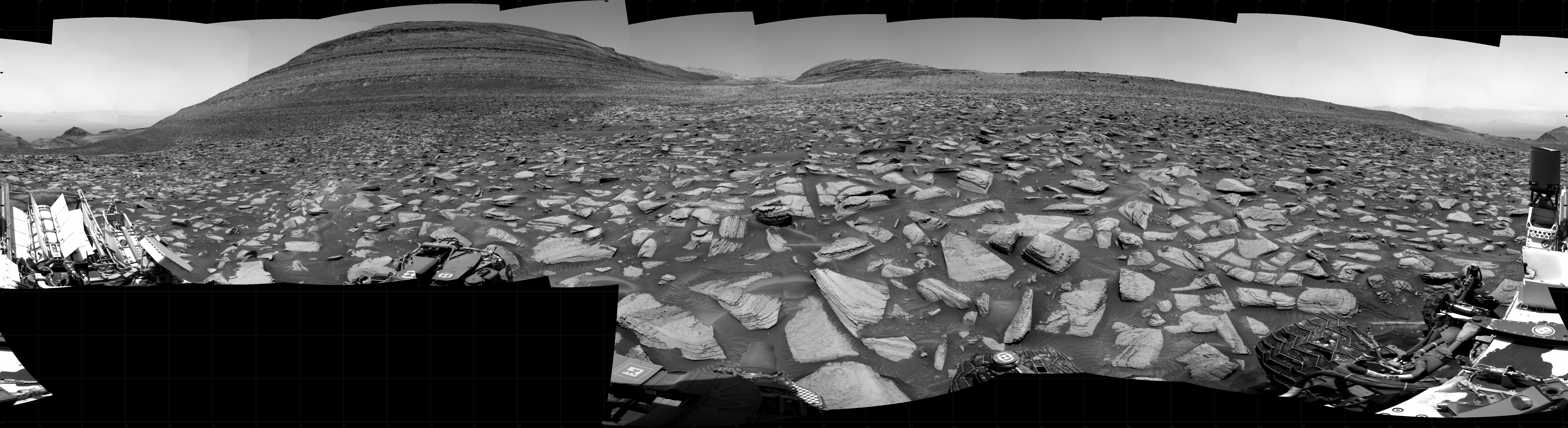
Panorama on December 20, 2023. Click for full image.
Click for original image.
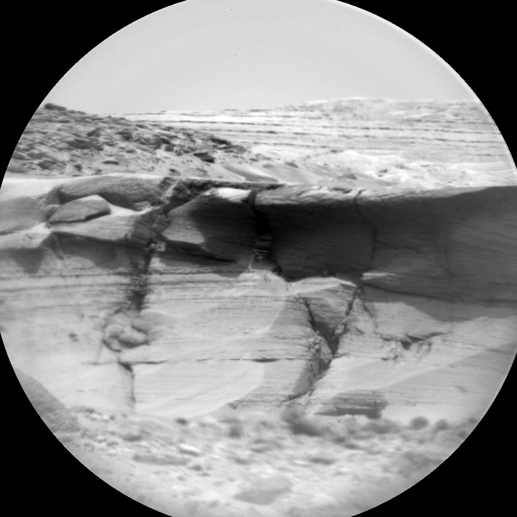
Cool image time! The picture to the right, reduced and sharpened to post here, was taken on December 21, 2023 by the chemistry camera (ChemCam) on the rover Curiosity. Originally designed to take close-ups of rocks very nearby the rover, the science team over time discovered that they could also use this camera to get close-ups of very distant objects, providing them another way to study the geology in Gale Crater and on Mount Sharp.
The picture to the right I think shows the horizon area indicated by the arrow on the panorama above, taken the day before. Note the many many layers, a geological feature that Curiosity has discovered is ubiquitous on Mars. Over eons the entire surface of the red planet has been layered repeatedly by cyclical geological events, producing layers within layers within layers. I guarantee that when Curiosity gets closer to this cliff it will see layers inside the smallest layers ChemCam can see now.
The red dotted line on the panorama above indicates the approximate planned route that Curiosity will eventually take, cutting across in front of that mountain and turning south somewhere near but to the west of where the cliff in this picture is located.
Click for interactive map
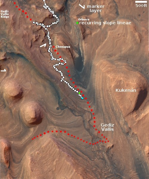
The overview map to the right provides us some further context. The panorama above covers more than 180 degrees of the view ahead, from the northern slope of Kukenan to the westernmost valley on the extreme left.
After the completion of a drill campaign in October and the end of the solar conjunction in November (location indicated by the green dot), Curiosity has been very very slowly climbing uphill, with each day’s journey very short as it twists and turns to find the best route across this very rocky terrain. Its present location is the blue dot.
For example, after its drive on December 18, 2023 it found one of its wheels was actually off the ground, and the planned drive the next day failed to get things cleared. The rover is in no danger, as this kind of thing has happened before. The reason it has six wheels, three on each side, is expressly to give it that extra stability when one wheel leaves the ground. It also gives it the traction to correct the problem.
Nonetheless, this rocky ground and issues like this slow travel down considerably. At this pace it will likely take four to six months to get to that small outcrop inside Gediz Vallis, where the rover will then turn west.

On Christmas Eve 1968 three Americans became the first humans to visit another world. What they did to celebrate was unexpected and profound, and will be remembered throughout all human history. Genesis: the Story of Apollo 8, Robert Zimmerman's classic history of humanity's first journey to another world, tells that story, and it is now available as both an ebook and an audiobook, both with a foreword by Valerie Anders and a new introduction by Robert Zimmerman.
The print edition can be purchased at Amazon or from any other book seller. If you want an autographed copy the price is $60 for the hardback and $45 for the paperback, plus $8 shipping for each. Go here for purchasing details. The ebook is available everywhere for $5.99 (before discount) at amazon, or direct from my ebook publisher, ebookit. If you buy it from ebookit you don't support the big tech companies and the author gets a bigger cut much sooner.
The audiobook is also available at all these vendors, and is also free with a 30-day trial membership to Audible.
"Not simply about one mission, [Genesis] is also the history of America's quest for the moon... Zimmerman has done a masterful job of tying disparate events together into a solid account of one of America's greatest human triumphs."--San Antonio Express-News
The panorama is fantastic! Another world and a picture taken by mankind.
Headline typo: “distance” should be “distant.”
Michael McNeil: Thank you. Fixed.
I bet the camera designers knew the camera could do that.
They were just not asked.
Bob:
Looking at the multiple elevations behind the cliffs I think this is pretty much in line with the track of the red dotted line, and not where thr white arrow is pointing. There seems to be no further elevations visible in that area.
For what it’s worth.
MDN: If you look at the highest resolution version of the panorama, you will see that there does not seem to a good match straight ahead in line with the dotted line. I thought that was the spot myself to begin with, but nothing fit. I then looked elsewhere for a place where more distant mountains AND a foreground cliff were in line, which is why I picked the spot with the arrow.
I also recognize there is guesswork here, so you might still be right.
The image from the ChemCam is amazing. Is it known what the elevation from the base of the cliff to the top is? I cannot get any sense of scale from anything in the picture.
The panorama view of the foreground looks exactly like water-driven sand over rocks, while in the ChemCam picture I keep expecting to spot a growth of sagebrush somewhere. It’s amazing how completely different processes can result in the same effects.
Blackwing1: The cliff in the Chemcam picture is only 20 feet high, approximately. The cliff face of the hill dubbed Kukenan in the overview map that is the big hill on the left of the panorama is about 100-250 feet high, depending on where you measure. On its front northern end the height is more, as much a 400 feet, depending on where you measure.