Ispace targets June 6, 2025 for the Moon landing its Resilience commercial lander
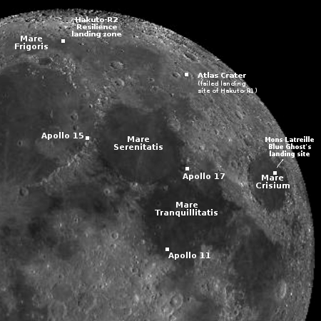
Map of lunar landing sites
Landing sites for both Firefly’s Blue Ghost and
Ispace’s Resilience

The Japanese startup Ispace announced today that its Resilience commercial lunar lander will attempt its touch down inside the Mare Frigoris region on the Moon on June 6, 2025, as shown on the map to the right.

Should conditions change, there are three alternative landing sites that are being considered with different landing dates and times for each. A decision about landing will be made in advance, but the window for landing is open from June 6 through June 8, 2025.

The company also reports that the spacecraft is healthy and operating exactly as expected.

Though Resilience was launched on the same Falcon 9 rocket that launched Firefly’s Blue Ghost lunar lander, it has taken a longer route to the Moon, which is why its landing will take place three months later.


0 comments

A galaxy surrounded by clusters of hot massive stars

A galaxy surrounded by hot massive stars
Click for original image.

Cool image time! The picture to the right, reduced and sharpened to post here, was taken by the Hubble Space Telescope of the galaxy NGC 5042, located about 48 million light years away. The picture combines data from all of Hubble’s available wavelengths from the ultraviolet to the infrared. From the caption:

Perhaps NGC 5042’s most striking feature is its collection of brilliant pink gas clouds that are studded throughout its spiral arms. These flashy clouds are called H II (pronounced “H-two”) regions, and they get their distinctive colour from hydrogen atoms that have been ionised by ultraviolet light. If you look closely at this image, you’ll see that many of these reddish clouds are associated with clumps of blue stars, often appearing to form a shell around the stars.

H II regions arise in expansive clouds of hydrogen gas, and only hot and massive stars [indicated by blue] produce enough high-energy light to create an H II region. Because the stars capable of creating H II regions only live for a few million years — just a blink of an eye in galactic terms — this image represents a fleeting snapshot of life in this galaxy.

The image also includes one star (distinguished by its four diffraction spikes) and a few background galaxies in yellow, the most obvious found in the upper and lower right.

0 comments

Blue Ghost successfully completes a soft landing

Blue Ghost's shadow on the Moon, with the Earth in the background
Blue Ghost’s shadow on the Moon, with the Earth in the background.

Firefly tonight became the second private commercial company to land a spacecraft softly on the Moon, its Blue Ghost successfully touching down within Mare Crisium on the northwest quadrant of the visible near side.

At this moment we do not have details about the spacecraft’s condition. Nonetheless NASA bigwigs have come out of hiding to celebrate (if the landing failed they would have likely quietly disappeared). Lots of blather about “important scientific research” but the most important data from this mission is the engineering.

I think the viewers would much rather stay with mission control to hear details about Blue Ghost’s condition. One big unknown is that, of the four landing leg pads, one did not register contact with the ground, though this appears to simply be a failure of the sensor. Just after landing one engineer in mission controler announced the spacecraft was stable, but more information would be of more useful than listening to upper managers from NASA puff themselves. (It is also getting tiresome that the announcers seem incapable of asking anything but “How do you feel?”, one of the most useless questions a journalist can ever ask.)

The first photos are expected shortly. I will update when available.

24 comments

Perseverance looks to the far west

Panorama taken by Perservance, February 28, 2025
Click for original image.

Overview map
Click for interactive map.

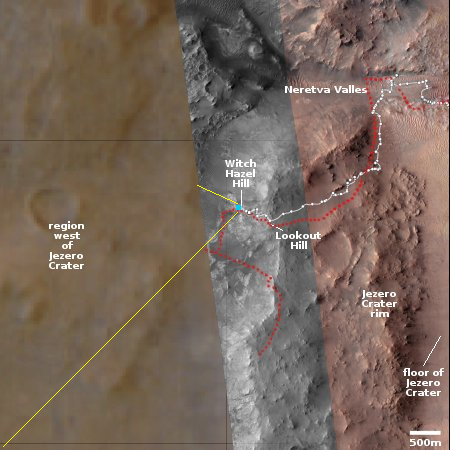
Cool image time! The panorama above, rotated, cropped, and enhanced to post here, was taken today by the left navigation camera on the Mars rover Perseverance. It gives us the first really good high elevation view of the mountainous terrain to the west of Jezero Crater

The overview map to the right provides the context. The blue dot marks the rover’s present position, with the white dotted line its past travels and the red dotted line its future planned route. The yellow lines are my approximate guess as to the area covered by the panorama above.

Neither the rover team nor the team running Mars Reconnaissance Orbiter (MRO) that provides the high resolution images of this region have as yet updated the interactive map to show this western region in high resolution. My guess as to why is that the planned route is not yet heading that way (as indicated by the red dotted line). When Perseverance has finished its exploration of the outer slopes of the rim of Jezero Crater and heads west, this fuzzy area on this map will likely be replaced with high resolution data, similar to the rest of the map.

Nonetheless, if you look close, you can distinguish several geological features seen in the panorama, such as the large crater to the right and the ridge line to the left. Beyond are mountain chains and valleys, as well as many additional craters. This is truly a barren and alien place, though it has enormous potential for eventually becoming a friendlier environment.

All that is required is for humans to live there, with the natural desire to make it so.

6 comments

Varda’s successfully returns its 2nd capsule from orbit

The startup Varda yesterday successfully returned its second capsule from orbit, with the capsule re-entering the atmosphere and touching down in Australia after spending six weeks in space.

The W-2 capsule carried a spectrometer built by the Air Force Research Laboratory (AFRL) and employed a heatshield developed in collaboration with NASA’s Ames Research Center in California’s Silicon Valley. The capsule also carried internal research that will expand Varda’s pharmaceutical processing capacity and capability.

The capsule landed at the Koomibba Test Range, operated by the spaceport startup Southern Range and located on the southern coast of Australia. Varda had arranged this landing location after it had absurd regulatory delays getting permission to land its first capsule at the Air Force test range in Utah.

0 comments

Exploring the canyons and plateaus of Valles Marineris

Overview map

The canyons inside Valles Marineris
Click for original image.

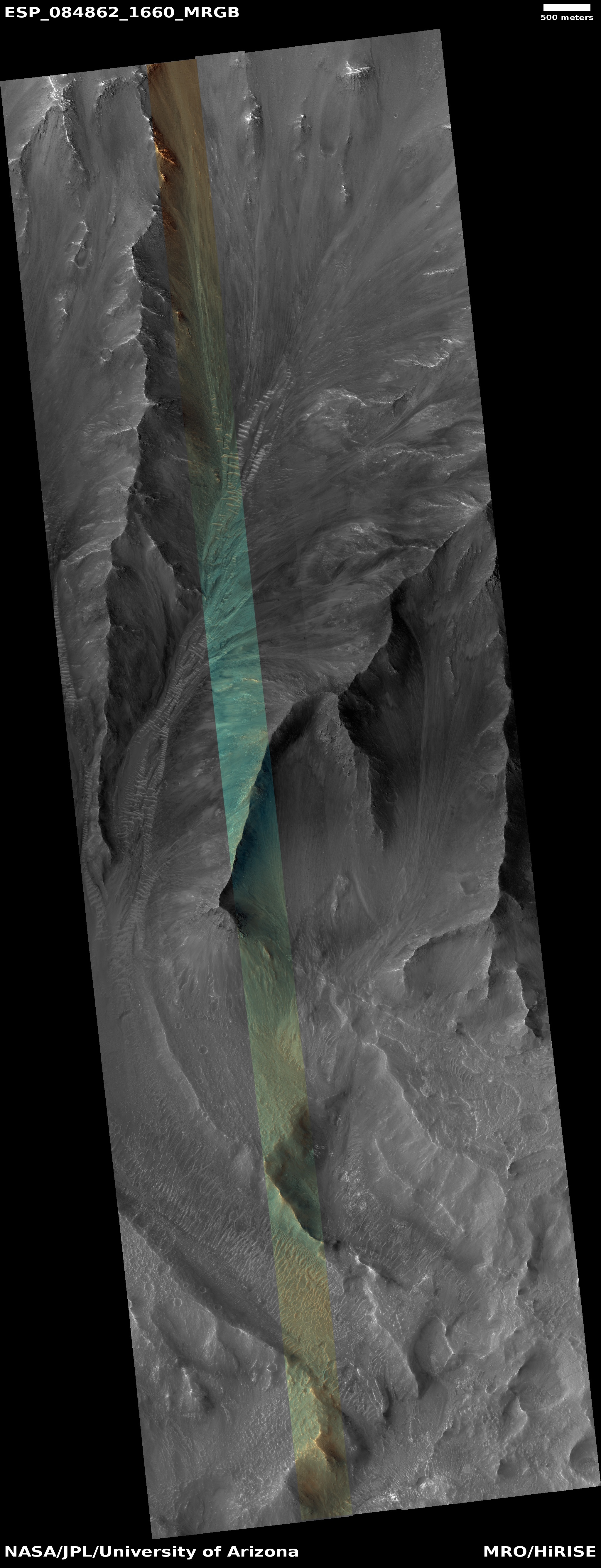
Cool image time! The picture to the right, rotated, cropped, reduced, and sharpened to post here, was taken on November 2, 2024 by the high resolution camera on Mars Reconnaissance Orbiter (MRO). It shows just one small section of a ridge that descends deep into the giant canyon Valles Marineris, the largest known canyon in the solar system.

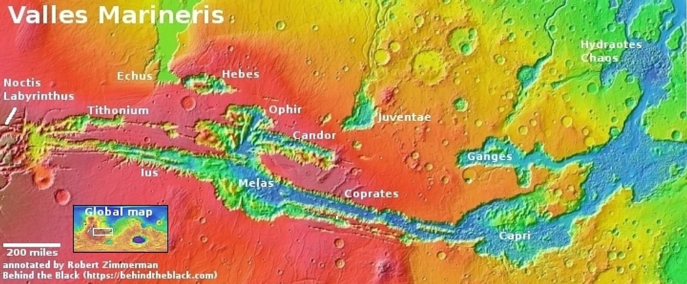
On the overview map above, the white dot inside the rectangle marks the location, in the westernmost section of the part of Valles Marineris dubbed Ius Chasma.

For scale, the nose of this ridge descends about 7,300 feet from the top to the bottom, about half the total descent from the small isolated plateau shown in the inset. That plateau, located in the mountainous region between Ius Chasma and Tithonium Chasma, rises to approximately the same elevation as the canyon’s rims to the north and south.

What this picture shows us is that Valles Marineris on its western end is both more shallow and broken up, forming several canyons and plateaus. As the catastrophic floods that are theorized to have carved this canyon pushed their way east, they carved a deeper gorge, so that about 1,500 miles to the east the canyon walls are considerable higher, from 20,000 to 30,000 feet in some places.

As always, the tourist in me can’t help look at this terrain and envision inns and hiking trails. Imagine homesteading that plateau where you build a hotel and trails. Since I expect much transportation on Mars will be by air, your guests would fly in, land at a heliport, and spend their visit hiking down into the canyons that surround them.

Damn! The future is going to so grand!

1 comment

All is so far well with Intuitive Machines Athena lunar lander

The Moon's South Pole with landers indicated
The Moon’s South Pole with landers indicated.
Click for interactive map.

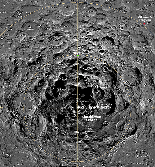
According to a tweet yesterday from Intuitive Machines, its Athena lunar lander is operating as expected since its launch last night.

The lander is in excellent health, sending selfies, and preparing for a series of planned main engine firings to refine her trajectory ahead of lunar orbit insertion, planned on March 3. Intuitive Machines is targeting a lunar landing opportunity on March 6.

If all goes as planned, Athena will land only 100 miles from the Moon’s south pole, as shown on the map to the right. This location had originally been picked for NASA’s now canceled VIPER rover, because the terrain would have allowed the rover to travel down into some permanently shadowed regions. NASA now hopes to use the Grace hopper on Athena to accomplish the same task.

Next week will also see a second privately built rover land on the Moon, though several days before Athena. Firefly’s Blue Ghost lander is scheduled to land on March 2, 2025 in Mare Crisium on the eastern edge of the Moon’s visible hemisphere. Furthermore, there is presently a third private lander on its way to the Moon, built by Japan’s Ispace. It is taking a longer route there, with its landing occurring in May.

There is also a fourth commercial lander, Astrobotic’s Griffin, that is presently targeting a launch by the end of 2025. It was originally supposed to carry VIPER, but has now replaced that with the commercial test prototype rover being built by the startup Venturi Astrolab, which is competing to get the contract to build the manned rover for NASA’s Artemis program.

Lunar exploration is certainly heating up.

Hat tip to reader Richard M for the Athena tweet update.

2 comments

Intuitive Machine’s Athena lunar lander to launch later today

The second attempt by the startup Intuitive Machines to soft land a spacecraft on the Moon is scheduled to launch today at 7:16 pm (Eastern) time on a Falcon 9 rocket lifting off from the Kennedy Space Center in Florida.

I have embedded the Space Affairs live stream feed below, because it starts only 45 minutes before launch. If you want to watch an extra hour of pre-launch blather and propaganda from NASA, the official live steam can be found here. Be warned however. All the live feeds are being produced by NASA, which tends to make believe it made everything happen, when in truth both the rocket and lander are privately owned and built. NASA is contributing most of the science instruments, but without SpaceX and Intuitive Machines, none of those instruments would go anywhere.

A very good description of the mission and the science instruments on board, including a hopper, and a drill, can be found here.

Secondary payloads on the rocket include a low cost NASA lunar orbiter and the first interplanetary probe of a private company.

The first, Lunar Trailblazer, has two instruments for mapping the existence of water on the lunar surface. The second, Astroforge’s Odin spacecraft, will attempt a close fly-by of the asteroid 2022 OB5, thought to be made up mostly of nickel-iron and thus potentially very valuable resource for mining.

» Read more

1 comment

Juno data proves volcanism on Io involves numerous lava lakes

The lava lakes of Io
A global map of Io’s lava lakes. Click for original figure.

Based on data and imagery produced by the Jupiter orbiter Juno as it made a series of fly-bys of the moon Io from 2022 to 2024, scientists have now mapped at least 40 lava lakes amid the numerous volcanoes on the planet. The map above, figure 2 of the paper, shows their location and approximate relative size across Io’s surface. From the paper’s abstract:

Recent observations from the Juno spacecraft have revealed at least 40 lava lakes on Io, one of Jupiter’s moons, using the JIRAM (Jovian InfraRed Auroral Mapper) imager. Most of the large depressions on Io, known as paterae, show signs of heat, indicating that lava lakes are common. The lava lakes vary in size from 10 to 100 km in diameter and have a thin crust, about 5–10 m thick, that appears to be a few years old. The heat observed mainly comes from the larger crust, not the small exposed lava, so it is hard to measure the total heat output from just the thermal data. Additionally, eight of these lava lakes are new discoveries and were not previously known as active hotspots.

One aspect of these lakes found repeatedly in this new data is that their lava appears to rise and fall as a unit, as if the lake’s floor bed acts like a huge piston pushing the whole lake up and down from below, rather than lava entering in or draining out from a central vent. This conclusion appears to settle the debate between these models for explaining why the lava almost never rises high enough to pour out from the lake. Instead, the lakes themselves appear to be stable features, not volcanic calderas from which lava flows to build a mountain.

0 comments

Lucy takes first picture of its next target asteroid

Lucy's future route through the solar system
Lucy’s route to the asteroids. Click for original blink animation.

The asteroid probe Lucy, on its way to the orbit of Jupiter to study numerous Trojan asteroids, has taken its first picture of the the main asteroid belt asteroid Donaldjohanson, which it will pass within 600 miles on April 20, 2025.

The map to the right shows the spacecraft’s looping route to get to the Trojans, with that image of Donaldjohanson in the lower right. Though the asteroid is about two miles side, it will remain an unresolved point of light until the day of the fly-by. This image was taken from a distance of 45 million miles. As for the asteroid’s name:

Asteroid Donaldjohanson is named for anthropologist Donald Johanson, who discovered the fossilized skeleton — called “Lucy” — of a human ancestor. NASA’s Lucy mission is named for the fossil.

After this encounter, Lucy will head to the Trojans, where it will visit its first six asteroids (including two binaries) in 2027-2028.

0 comments

The Europa Clipper team prepares for Mars fly-by

Europa Clipper's route to Jupiter
Click for original image.

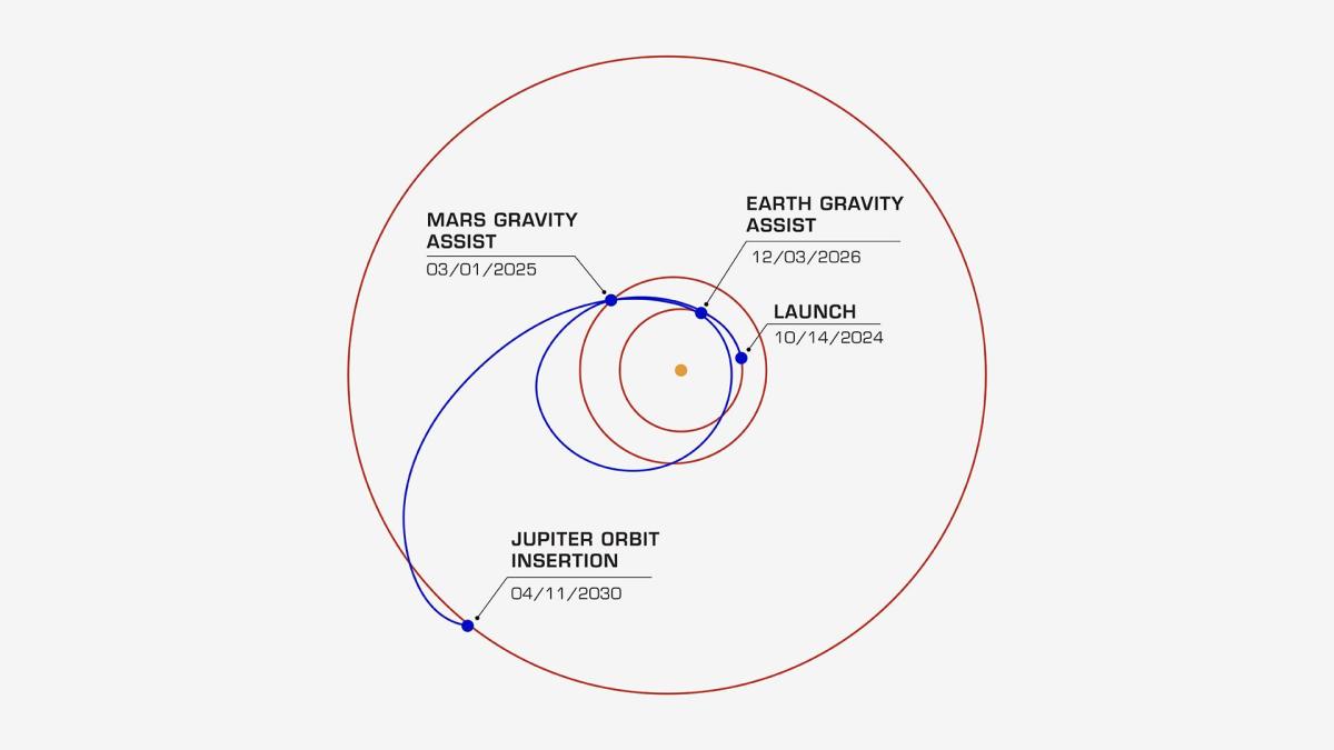
As planned, Europa Clipper is set to do a very close fly-by of Mars on March 1, 2025, zipping past the red planet at a speed of 15.2 miles per second only 550 miles above its surface. The graphic to the right shows the spacecraft’s planned route to Jupiter, including an additional fly-by of Earth in 2026.

During this first fly-by the science team will test two of Europa Clipper’s instruments.

About a day prior to the closest approach, the mission will calibrate the thermal imager, resulting in a multicolored image of Mars in the months following as the data is returned and scientists process the data. And near closest approach, they’ll have the radar instrument perform a test of its operations — the first time all its components will be tested together. The radar antennas are so massive, and the wavelengths they produce so long that it wasn’t possible for engineers to test them on Earth before launch.

The spacecraft launched with transistors not properly hardened for the hostile environment around Jupiter. Engineers claimed these would “heal” themselves once in Jupiter orbit. No word on whether there has been any issue from these components since launch.

0 comments

Bumpy frozen lava on Mars

Bumpy frozen lava on Mars
Click for original image.

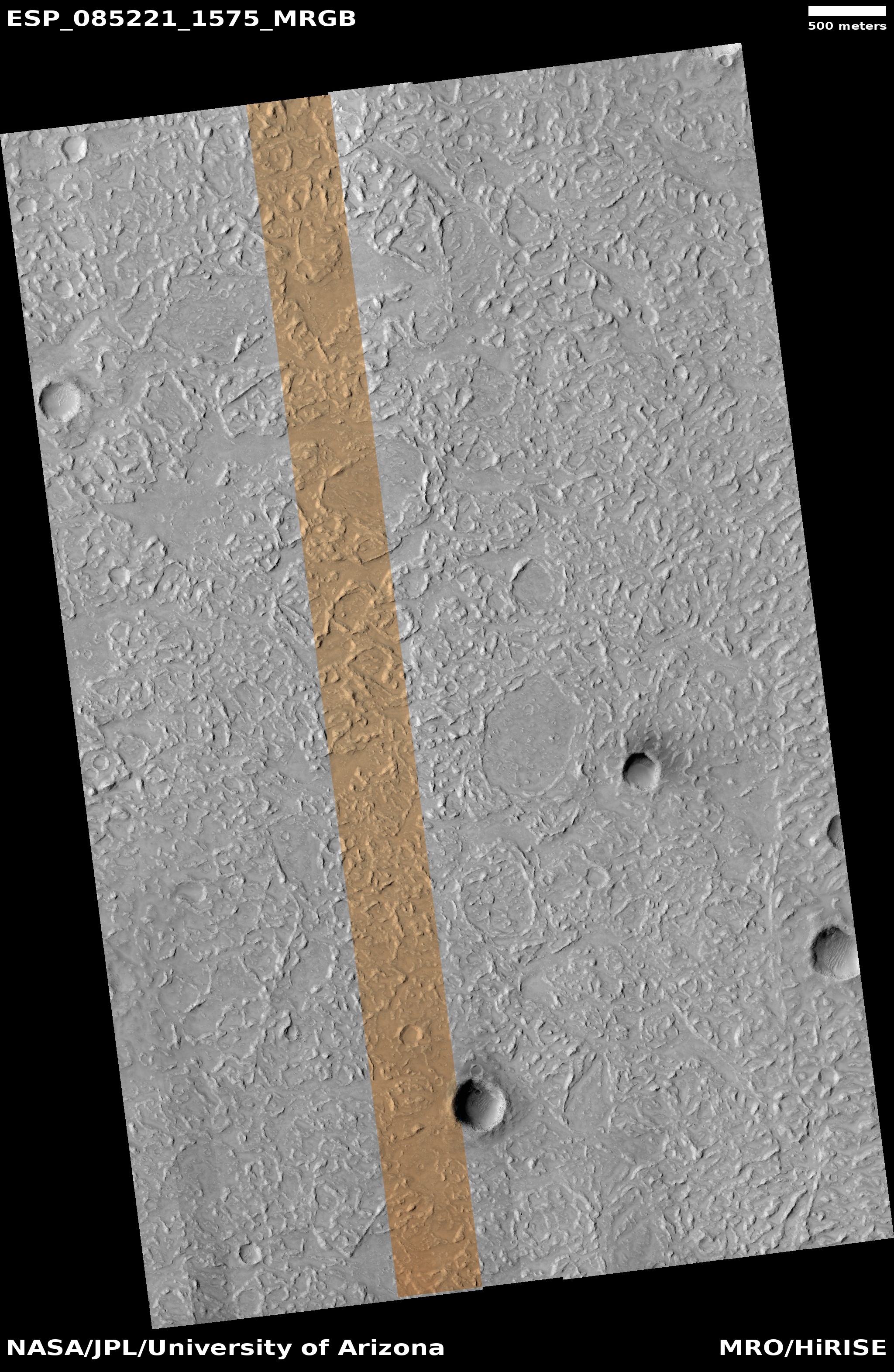
Cool picture time! The photo to the right, cropped, reduced, and sharpened to post here, was taken on September 30, 2024 by the high resolution camera on Mars Reconnaissance Orbiter (MRO). Labeled simply as a “terrain sample,” it was most likely taken not as part of any specific research project but to fill a gap in the schedule in order to maintain the camera’s temperature.

The image is fascinating nonetheless, as the landscape is typically alien for Mars. What caused the many random ridges and knobs? Why are there oblong areas that are smooth and have no ridges? And why is there dark material inside that crater that appears to have been blown out to the northeast? If you click on the image to see the full image, not all the craters look this way. One has a similar dark feature, but others are as bland as the entire terrain.

The overview map below only increases these mysteries, even if it does provide some further data.
» Read more

0 comments

A Martian glacier of dust

A Martian glacier of dust
Click for original image.

Cool image time! The picture above, rotated, reduced, and sharpened to post here, was taken on September 2, 2024 by the high resolution camera on Mars Reconnaissance Orbiter (MRO).

The tiny white dot near the lower center of the overview map below marks the location, on the northern wall of the smaller parallel canyon to the much larger part of Valles Marineris dubbed Coprates Canyon.

The scientists label this a “slope deposit.” What I see is a dust glacier flowing down hill in that long hollow (indicated by the arrows), with the ripple dunes actually acting almost like waves. Nor is this description unreasonable. On Mars the dust will gather in the hollows of these slopes and over time, with no rain and little wind to disturb them, will begin to flow down much like a glacier.

In this case, the descent is gigantic, considering the size of Valles Marineris. From the top to bottom of this image the elevation drop is about 14,000 feet over a distance of 11 miles.

Overview map

1 comment

The broken edge of Mars’ largest volcanic ash field

The broken edge of Mars' largest volcanic ash field
Click for original image.

Overview map

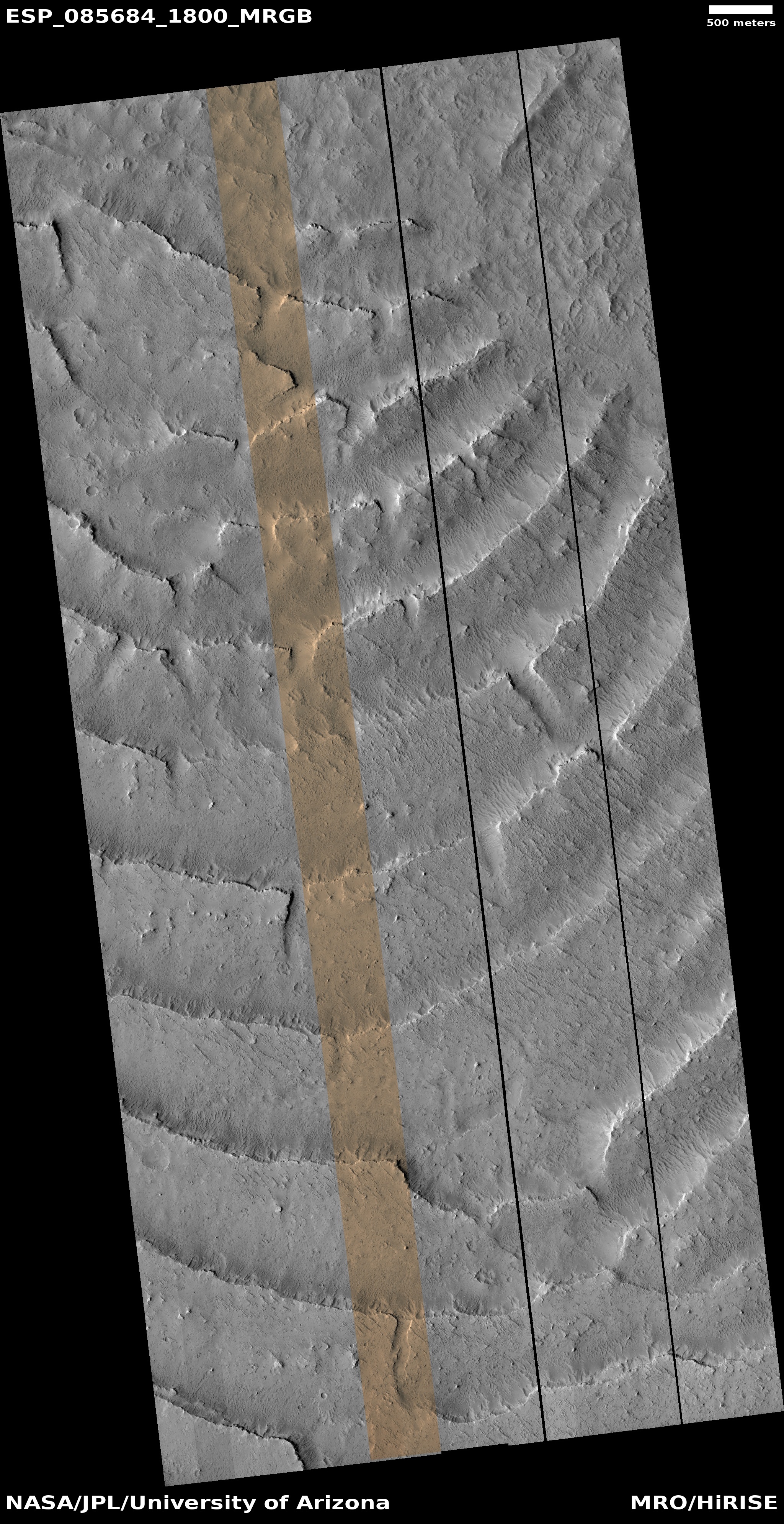
Cool image time! The picture above, reduced and rotated to place north to the left, was taken on November 5, 2024 by the high resolution camera on Mars Reconnaissance Orbiter (MRO).

The science team labeled it “Stepped Features in Tartarus Skopulus”. The white dot on the overview map to the right marks the location, right at the equator on the northern edge of the Medusae Fossae Formation, the largest volcanic ash field on Mars, about the size of the subcontinent of India. As I wrote in a post in 2024:

It is believed that most of the planet’s dust comes from this ash field. It is also evident that the ash is a leftover from the time period more than a billion years ago when the giant volcanoes that surround this field were erupting regularly. The eruptions laid down vast flood lava plains that coat the surface for thousands of miles.

The ash either came from the eruptions themselves, or was created as the thin Martian wind eroded those flood lava plains, slowly stripping ash from the top. The ash then gathered within the black-outlined regions on the map.

In that 2024 post the cool image showed another location on the north edge of Medusae. In that case the prevailing wind had carved long parallel ridges as it pulled ash from the field.

Here, the wind appears to play no part, or if it did, it produced a very different terrain. At first glance it appears the stepped terraces formed as the ash field began to slide downhill to the north, spreading to crack along the curved lines. The inset especially suggests this explanation.

A closer look instead suggests these terraces each represent a different layer of ash placed down by a sequence of eruptions. Over time the prevailing winds, which here appear to generally blow to the south, stripped off the top of each layer, creating this stair-step landscape.

I however have no guess as to why the terraces are curved. Regardless, it is all strange, but quite beautiful in its own way.

0 comments

Blue Ghost lowers its lunar orbit while shooting a movie of the Moon

The company Firefly announced that its lunar lander Blue Ghost successfully completed 3:18 minute engine burn that tightened its orbit around the Moon.

This maneuver moved the lander from a high elliptical orbit to a much lower elliptical orbit around the Moon. Shortly after the burn, Blue Ghost captured incredible footage of the Moon’s far side, about 120 km above the surface.

I have embedded the movie below. Quite spectacular indeed. The spacecraft is still on target for a March 2, 2025 landing attempt.
» Read more

3 comments

Glacial material even in Mars’ Death Valley

Glacial material even in Mars' Death Valley
Click for original image.

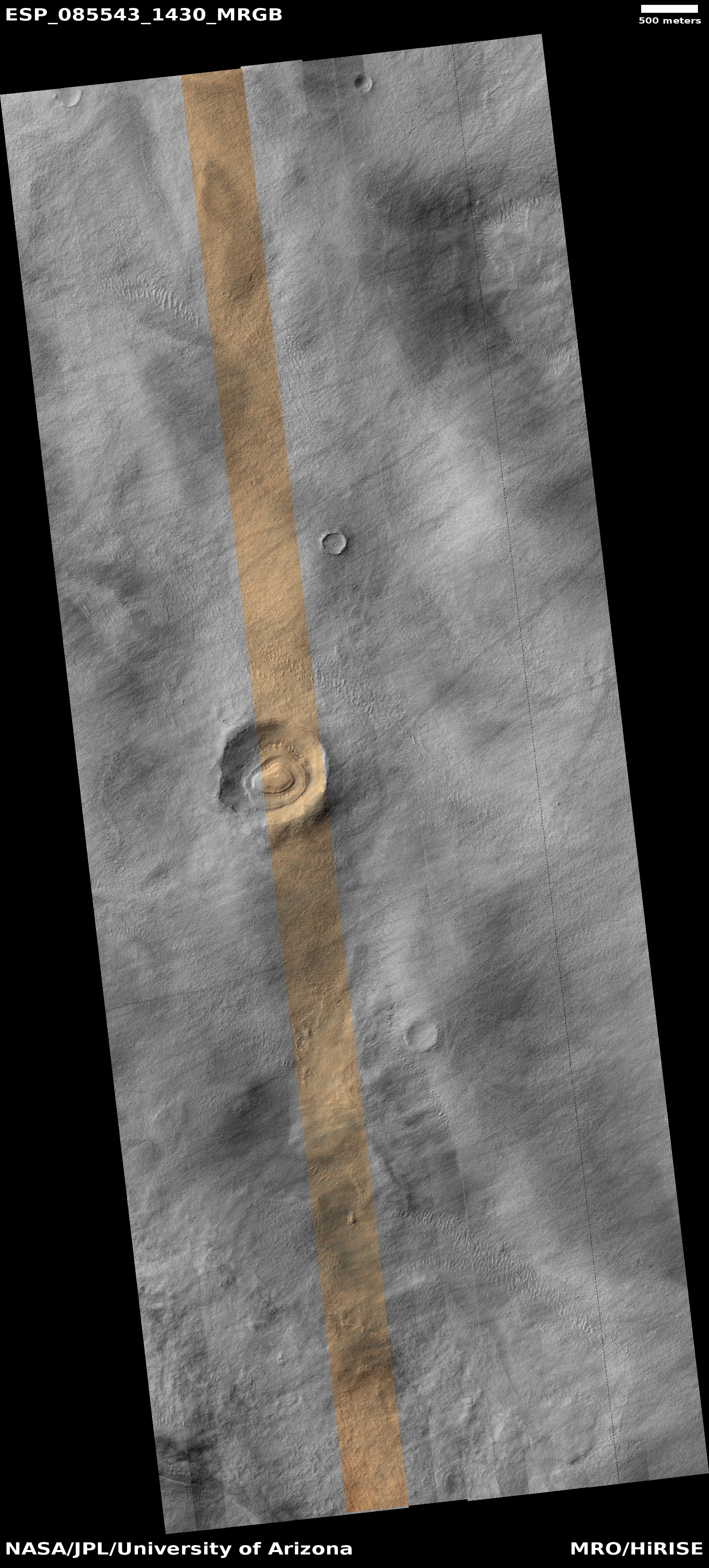
Cool image time! The picture to the right, cropped, reduced, and sharpened to post here, was taken on October 25, 2024 by the high resolution camera on Mars Reconnaissance Orbiter (MRO).

The science team labels this a “layered feature,” which is appropriately vague in order to not prematurely push a conclusion that is not yet proven. Extensive orbital imagery and data however strongly suggests the layers inside this crater are glacial in nature, each layer laid down during Mars’ many thousands of climate cycles as the planet’s rotational tilt swung back and forth from 11 degrees to 60 degrees. According to the most popular theory today, when that tilt was high, the mid-latitudes (where this 3,000-foot-wide unnamed crater is located) were actually colder than the planet’s poles. The water ice at the icecaps would then migrate from the poles to the mid-latitudes, causing the glaciers to grow.

When the tilt was low the process would reverse, with the mid-latitudes now warmer than the poles, causing the glaciers to shrink. The wedding cake nature of these layers is likely because, over time, Mars has steadily lost its total budget of water to space, so with each cycle the glacier could not grow as much.

Though many such glacial-filled craters have been found in the mid-latitudes, reinforcing these theories, the location of this crater is even more interesting.
» Read more

0 comments

Ispace’s Resilience lunar lander completes lunar flyby in preparation for entering lunar orbit

The Resilience lunar lander, built by the Japanese startup Ispace and launched in January on the same Falcon 9 rocket as Firefly’s Blue Ghost lunar lander, has now completed its closest flyby of the Moon as it prepares to enter lunar orbit sometimes in early May.

The spacecraft is actually still in Earth orbit, but with a apogee that is almost 700,000 miles out, or almost three times the distance of the Moon’s orbit. Once Ispace’s engineers have gotten a precise track of this orbit they will then determine the exact parameters of the engine burn in May that will place Resilience in lunar orbit.

This is Ispace’s second attempt to place a lander on the Moon. The first, Hakuto-R1, came close, but crashed in Atlas Crater (see the map in my previous post) when, at an altitude of several kilometers, its software thought it was only a few feet above the surface and shut the engines off.

Most of the instruments on Resilience are either symbolic or engineering experiments to observe the lander’s operations. It is however carrying a small rover, dubbed Tenacious, which will attempt to travel on the surface.

6 comments

Blue Ghost enters lunar orbit, targets March 2, 2025 for landing

Map of lunar landing sites
Landing sites for both Firefly’s Blue Ghost and
Ispace’s Resilience

Blue Ghost on February 13, 2025 successfully completed a long four-minute engine burn to complete its transfer from Earth to lunar orbit, with a target date for the actual landing on March 2, 2025.

Now that the lander is in lunar trajectory, over the next 16 days, additional maneuvers will take the lander from an elliptical orbit to a circular orbit around the Moon. Blue Ghost Mission 1 is targeted to land Sunday, March 2, at 3:45 a.m. EST.

NASA has also announced the live stream coverage during landing:

Live coverage of the landing, jointly hosted by NASA and Firefly, will air on NASA+ starting at 2:30 a.m. EST, approximately 75 minutes before touchdown on the Moon’s surface. Learn how to watch NASA content through a variety of platforms, including social media. The broadcast will also stream on Firefly’s YouTube channel. Coverage will include live streaming and blog updates as the descent milestones occur.

I will embed the Firefly live stream when it becomes available.

2 comments

Pits formed from sublimating underground ice on Mars?

Pits formed from sublimating underground ice
Click for original image.

Cool image time! The picture to the right, cropped, reduced, and sharpened to post here, was taken on October 31, 2024 by the high resolution camera on Mars Reconnaissance Orbiter (MRO).

The science team labels this “Impact Ejecta with Marginal Pits,” though even on the full image I am not sure what the impact ejecta is. The pits themselves appear to have formed when near-surface ice sublimated away during the summer months. The location is at 59 degrees north latitude, deep within the Martian northern lowland plains. Since orbital data suggests much of those plains at this latitude has an ice table of some thickness near the surface, it is very reasonable to assume these pits formed when summer sunlight heated that ice, turning it to gas which eventually pushed out to form the pits.

But what about the impact ejecta? Where is it? And where is the crater from that impact?
» Read more

2 comments

A pimple on Mars

A pimple on Mars
Click for original image.

Cool image time! The picture to the right, cropped, reduced, and sharpened to post here, was taken on November 1, 2024 by the high resolution camera on Mars Reconnaissance Orbiter (MRO). Labeled simply as a “terrain sample,” it was likely not taken as part of any specific research project, but to fill a gap in the camera’s schedule in order to maintain its proper temperature. When the camera team does this they try to pick something interesting, and sometimes succeed.

I think they succeeded in this case. At first glance this appears to be a crater, but on closer inspection it is instead a small mound. The picture was taken in the winter, at the high latitude of 55 degrees north. The featureless white surface surrounding this dark mound is almost certainly the mantle of dry ice that falls as snow and covers the poles during the winter. If not that, it is then likely to be a water ice sheet that orbital data suggests covers much of Mars’ high latitudes.
» Read more

1 comment
1 20 21 22 23 24 56