A rash on Mars

A Martian rash
Click for original image.

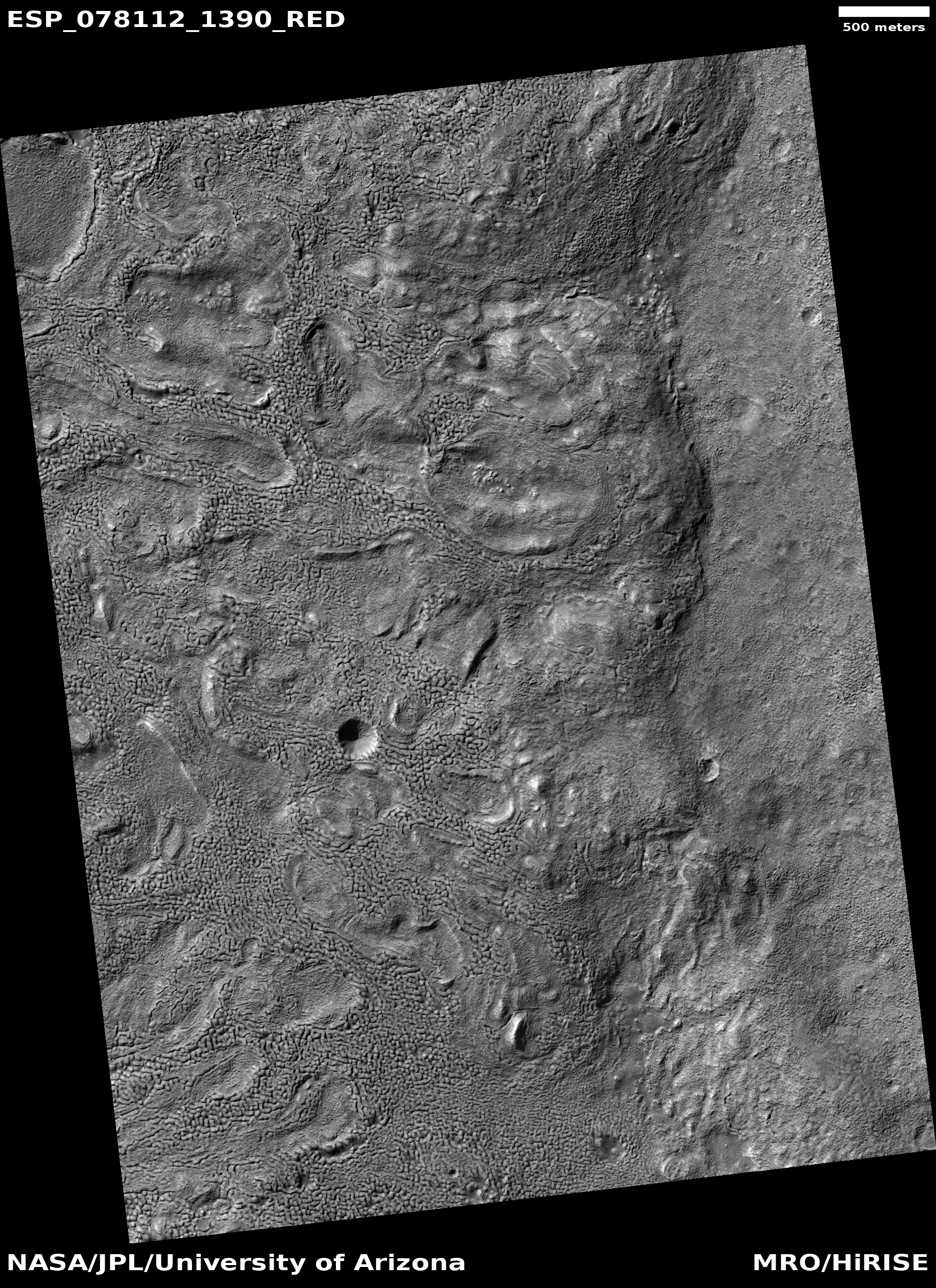
Cool image time! The picture to the right, rotated, cropped, reduced, and sharpened to post here, was taken on January 30, 2023 by the high resolution camera on Mars Reconnaissance Orbiter (MRO). The science team labeled this a “Circular Outcrop of Bright Rock.

What I see is a Martian skin rash. Based on the ripple pattern below the ridge one might think we are looking at sand dunes, except that the rash above the cliff has no such pattern. Instead, the ground in this one particular area looks very roughened in a random sort of way.

The location at 27 degrees south latitude suggests there is little near surface ice at this location to cause this feature. The overview map below provides another but not very helpful possibility.
» Read more

2 comments

Paperwork on Mars

Paperwork on Mars
Click for original image.

Cool image time! The picture to the right, cropped, reduced, and sharpened to post here, was taken on April 15, 2023 by the close-up camera on the Mars rover Curiosity. From the caption:

NASA’s Curiosity Mars rover took this close-up view of a rock nicknamed “Terra Firme” that looks like the open pages of a book, on April 15, 2023, the 3,800th Martian day, or sol, of the mission, using the Mars Hand Lens Imager (MAHLI) on the end of its robotic arm. The rock is about an inch across (2.5 centimeters).

Strange looking rocks like this have not been rare during Curiosity’s travels in Gale Crater, though it seems to me that the variety and strangeness has increased as the rover has climbed higher on Mount Sharp. In this case, the tall flake in the center — as well as the shorter flakes to the left — were among the many thin layers seen in this area. These layers however were clearly made of much harder material than the layers above and below. Those weaker layers eroded away over the eons, leaving behind these thin sheets.

Also, if you own red-blue 3D glasses, take a look at the anaglyph here.

3 comments

Sinuous ridge inside Martian canyon

Sinuous ridge inside a Martian canyon
Click for original image.

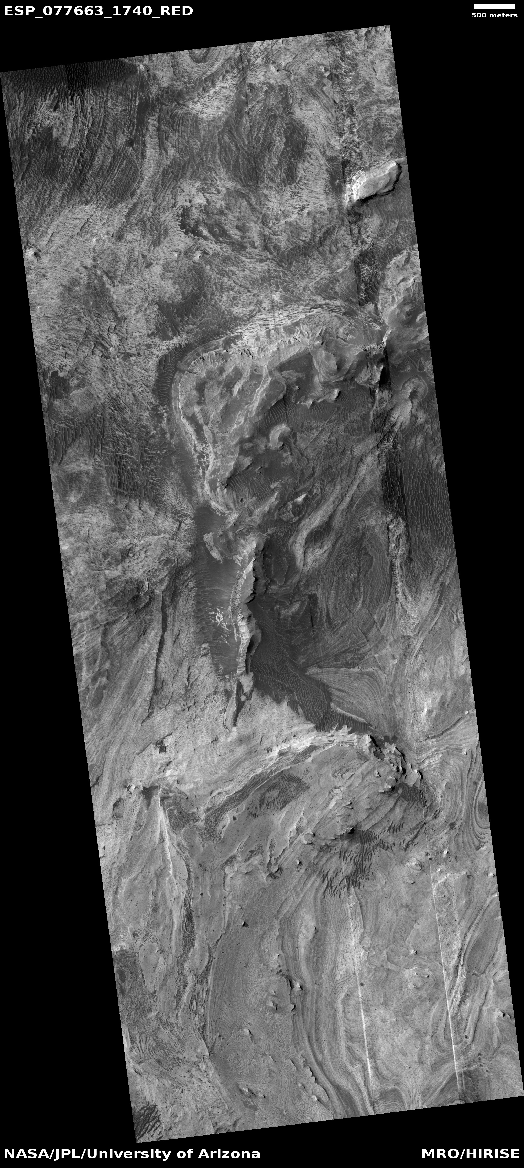
Cool image time! The picture to the right, cropped, reduced, and sharpened to post here, was taken on February 7, 2023 by the high resolution camera on Mars Reconnaissance Orbiter (MRO). It shows what the camera team labels a “sinuous ridge within valley.”

The location is at 30 degrees south latitude, right on the edge of the southern of the two 30-60 degree mid-latitude bands where orbital images show many glacial features. Closer to the equator and there is little or no evidence of near surface ice on Mars. Farther from the equator from this latitude and the evidence of near surface ice increases, becoming very dominant the closer to the poles you get.

At this spot, it appears there is little near surface ice. The channel has ripple sand dunes inside it, and the sinuous ridge appears to be bedrock. Similarly, the plateau above the channel also appears like bedrock, the craters showing no evidence of splatter that is common where there is near surface ice.

What made the channel? And what made that a sinuous ridge inside it?
» Read more

0 comments

Brain terrain on top of Martian mountains

Brain terrain at high elevation on Mars
Click for original image.

Cool image time! The picture to the right, cropped and reduced to post here, was taken on March 26, 2023 by the high resolution camera on Mars Reconnaissance Orbiter (MRO). It is labeled by the scientists “Brain Terrain on Floor of Crater in Warrego Valles.”

Brain terrain is a geological feature entirely unique to Mars that remains unexplained in any way by geologists. The scientists know it is almost certainly related to near-surface ice and its sublimation into gas, but their theories as to its precise formation process remain incomplete and unconvincing, even to them.

In this case the brain terrain’s interweaving nodules seem to show flow patterns, but strangely those patterns go around depressions and hollows. Yet, the overall flow direction also seems to point downhill towards the slope on the image’s right edge.
» Read more

5 comments

Weird dome near Starship candidate landing zone on Mars

Weird dome near Starship candidate landing zone on Mars
Click for original image.

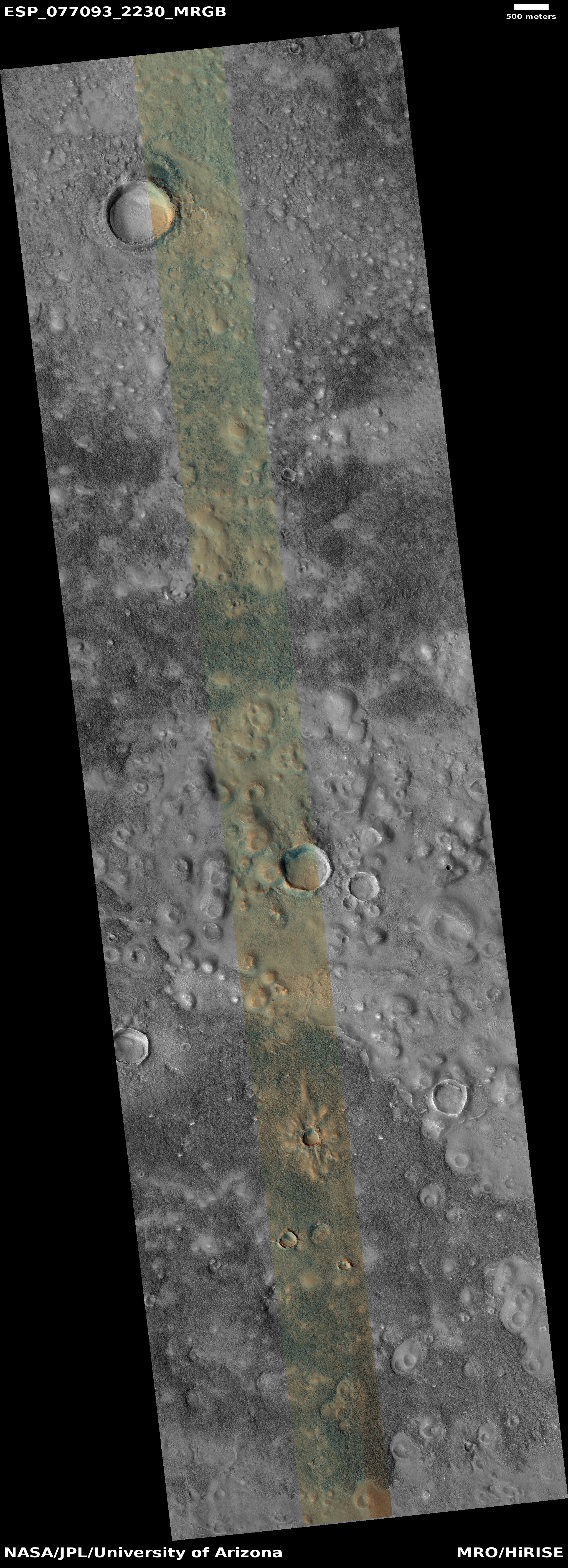
Cool image time! The picture to the right, rotated, cropped, reduced, and sharpened to post here, was taken on February 27, 2023 by the high resolution camera on Mars Reconnaissance Orbiter (MRO). It shows what the scientists label as domes in Arcadia Planitia, one of the many large northern lowland plains of Mars.

This to me is a “What the heck?” image. I won’t dare try to explain the warped concentric ringed pattern at the top of the mesa, nor the bright and dark splotch that surrounds it. The small craters around it appear to have glacier material within them, and the terrain here likely has a lot of near surface ice, being at 37 degrees north latitude in a region where the data suggests such ice exists. The different colors here likely indicate the difference between dust (orange) and coarser material (aqua).

The location, as shown in the overview map below, makes this mesa more tantalizing.
» Read more

5 comments

In a Martian cold cauldron, boil and bake

bubbles and boiling ground
Click for original image.

Cool image time! My headline paraphrases slightly the witches’ chant from Shakespeare’s MacBeth, if only to make it more accurately describe the picture to the right, cropped and reduced to post here. Taken on January 5, 2023 by the high resolution camera on Mars Reconnaissance Orbiter (MRO), it shows a patch of mid-latitude terrain in the icy northern lowland plains of Mars.

While some of the craters here were certainly caused by impact, it is also likely that most were instead cryo-volcanic in nature, whereby ice bubbles up from below as changing temperature conditions — none of which need to be very warm — cause it to either melt temporarily into liquid or sublimate directly into a gas. The dark pimplelike hole on the picture’s right edge is a perfect example, with the hole sitting at the top of a cone.
» Read more

0 comments

SuperBIT balloon circling Antarctica snaps more high resolution astronomical pictures

Sombrero Galaxy
Click for full image.

The Super-Pressure Balloon Imaging Telescope (Super-BIT) that has been circling Antarctica for the last two weeks has now obtained two more more high resolution wide-field astronomical pictures.

The picture to the right, cropped to post here, is of Messier 104 (the Sombrero Galaxy). While the telescope cannot zoom in closer than this to such objects, it is able to get much wider and sharp pictures, covering an entire galaxy or nebula that ground-based telescope using adaptive optics (designed to counter the fuzziness caused by the atmosphere) cannot. Adaptive optics only work on very small fields of view, thus making it unable to observe some of the larger nearby astronomical objects like galaxies and nebulae.

If you look at the live stream of the balloon’s track, it has now almost completed its second circuit of Antarctica.

3 comments

Astronomers record moment star eats planet

Animation of a star eating a planet
Click to watch full animation.

Using data from a variety of space- and ground-based telescopes, astronomers now think they have recorded the moment a star similar to our Sun actually swallowed a planet thought to be comparable to Jupiter or smaller.

Once the science team put all the evidence together, they realized the dust they were seeing with NEOWISE [in orbit] was being generated as the planet spiraled into the starโ€™s puffy atmosphere. Like other older stars, the star had begun to expand in size as it aged, bringing it closer to the orbiting planet. As the planet skimmed the surface of the star, it pulled hot gas off the star that then drifted outward and cooled, forming dust. In addition, material from the disintegrating planet blew outward, also forming dust.

What happened next, according to the astronomers, triggered the flare of optical light seen by ZTF [survey telescope in California]. โ€œThe planet plunged into the core of the star and got swallowed whole. As it was doing this, energy was transferred to the star,โ€ De explains. โ€œThe star blew off its outer layers to get rid of the energy. It expanded and brightened, and the brightening is what ZTF registered.โ€

Some of this expanding stellar material then escaped from the star and traveled outward. Like the boiled-off layers of the star and planet that previously drifted outward, this material also cooled to form dust. NEOWISE is detecting the infrared glow of all the newly minted dust.

The picture above is a screen capture from a short artist’s animation created to illustrate what happened. The most amazing aspect of this event is how long the planet skimmed the surface of that star. It appears it did so for several orbits at least.

2 comments

The cliff wall of ancient Martian lava channel

The cliff wall of an ancient Martian lava channel
Click for original image.

Cool image time! The picture to the right, cropped, reduced, and sharpened to post here, was taken on January 17, 2023 by the high resolution camera on Mars Reconnaissance Orbiter (MRO) by the camera team not as part of any particular research project but in order to fill a gap in the camera’s schedule so as to maintain its proper temperature. In such cases the camera team tries to pick potentially interesting spots.

This cliff, about 1,100 feet high, is the north wall of a major volcano channel flowing across the Tharsis Bulge, the lava plains that surround Mars’ giant volcanoes. Located in the dry equatorial regions, there is no near surface ice here, but a lot of dust, much of it likely volcanic ash. In the full picture are several ancient craters, all of which are almost entirely buried by this dust and ash.

The cliff wall itself is made up of numerous layers, each representing a past volcanic flood lava event that covered this region with a new flow of material. These events occurred over more than a billion years.
» Read more

1 comment

Exploring just one small corner of Valles Marineris, Mars’ Grand Canyon

One corner of Valles Marineris
Click for original image.

Cool image time! The picture to the right, rotated, cropped, reduced, and sharpened to post here, was taken on February 19, 2023 by the high resolution camera on Mars Reconnaissance Orbiter (MRO). It shows the many many many layers that are found in the cliffs of Valles Marineris, the largest known canyon in the solar system and far far larger that Earth’s Grand Canyon.

The elevation difference between the red dots is just under 4,000 feet. Yet that high point is still more than 7,000 feet below the rim of the canyon, more than thirty miles to the south. And the lower dot is still about 18,000 feet above the low point in this side canyon of Valles Marineris, about thirty miles away to the northeast.

In other words, in sixty miles from rim to floor the canyon at this location drops about 25,000 feet, only 4,000 feet less than the height of Mount Everest. Compare that with the Grand Canyon’s slopes, which drops in eleven miles about 5,000 feet, beginning at the main south rim lookout at the start of Bright Angel trail.
» Read more

0 comments

Galaxies without end

Galaxies without end
Click for full image.

Cool image time! The picture to the right has been significantly reduced but also significantly sharpened to post here. It was taken by the Hubble Space Telescope as part of a recent survey of “jellyfish” galaxies, galaxies located in galaxy clusters where there is a large concentration of galaxies whose combined gravity and intergalactic environment acts to pull material or “tendrils” out from the galaxy.

Rather than crop the image to focus on that single large central jellyfish galaxy, I have instead sharpened the much-reduced full photo to bring out clearly the number of surrounding galaxies. There is only one Milky Way star in this picture, the object with the four diffraction spikes in the lower-right. Every other dot is a galaxy, many of which can be seen to be very strangely shaped in the original full resolution image. In fact, I strongly recommend you click on the picture to explore that original image, just to see the variety of galaxy shapes.

The point of this picture today however is not to illustrate the wide variety of galaxies that can exist, but to underline the vast and largely incomprehensible scale of the universe. The large galaxy is thought to be 650 million light years away, which means it took light traveling at 186,000 miles per second that many years to get here. The surrounding galaxies are also all tens to hundreds of millions of light years from each other. Yet, their combined gravity, almost infinitesimal in strength, is enough to warp the shape of each.

We understand these numbers and facts intellectually, but do we understand them in reality? I think it is difficult, even if you work hard to come up with a scaled comparison. For example, it took nine years for the New Horizons spacecraft to get from Earth to Pluto, a distance of about 4.5 light hours. And New Horizons was the fastest traveling probe ever launched, moving at 36,400 miles per hour when it left Earth. Yet, this distance is nothing compared to the distance between these galaxies.

The vastness of existence really is beyond our comprehension. That we try to comprehend it speaks well of the human desire to achieve the impossible.

4 comments

Glacier layers on the border of Hellas Basin

Dipping glacial layers
Click for original image.

Cool image time! The picture to the right, cropped and reduced to post here, was taken on February 21, 2023 by the high resolution camera on Mars Reconnaissance Orbiter (MRO). It shows what the scientists label as “dipping layers”, referring specifically to the mesas with the terraces on their western flanks.

The layers obviously signify past cycles of geological events on Mars. That the terraces are only on one side of the mesas suggests that they are tilted, with the downhill grade to the east.

These layers however pose several mysteries. First, why are they located so specifically in only certain places of this region? It appears that the layered terrain is only found in the lower hollows and valleys. Why?

Second, why are they tilted at all?
» Read more

0 comments
1 70 71 72 73 74 89